Lecture 23- more rivers and glaciers
1/36
There's no tags or description
Looks like no tags are added yet.
Name | Mastery | Learn | Test | Matching | Spaced |
|---|
No study sessions yet.
37 Terms
River Landscapes
As rivers meander, they transform landscape
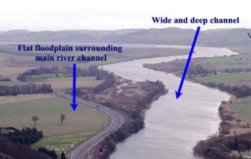
Floodplain: flat, low-lying area adjacent to stream channel
When a river floods, its velocity and capacity slows
Depostion of alluvium occurs as river spreads out to floodplain
Leaves a natural levee alongside river
River Deltas
When rivers meet the sea, velocity slows rapidly
Decreases stream capacity; deposition occurs
Delta: deposited material at mouth of river
Rivers deposit huge amounts of sediment into deltas
Coarser near mouth, finer near end
Some sediment may be underwater
Areas of active land growth
Deltas play important ecological role
Can protect inland areas by absorbing storm impact
Delta landscapes
Low-lying marshes from deposited sediment
The current Mississippi Delta has been forming for 500 years at this location, gradually pushing into the sea
Deltas depend on sediment from the river
If sediment decreases, the land sinks towards the sea
Dams built since 1950s have trapped more than 70% of the Mississipi’s sediment
Much of the delta marshland has receded
Increases vulnerability to hurricanes and storms
Deltas and River Evolution
Deposition at deltas gradually decreases river gradient.
During floods, river will attempt to take a more direct route to the ocean
More direct route usually through a nearby river
The river will begin to divert some of its flow to the new, more direct, river system (delta switching; avulsion.)
Old delta stops receiving sediments, slowly sinks
New delta forms at the river’s new endpoint
Mississippi River
Has had many deltas in the recent past
It has followed its current path for the past 500 years
Delta extends so far into the Gulf that gradient is shallow
If the Mississippi switched paths it would devastate New Orleans and southern Louisiana
Army Corps of Engineers has dams and lock between the Mississippi and Atchafalaya to prevent this
Old River Control Project: cost $2.3 billion in today’s dollars when built in 1963
In 2011, the Army Corps of Engineers opened the Morganza Spillway to allow Mississippi water into the Atchafalaya (and prevent flooding in New Orleans.
Atchafalaya River
has a much more direct route to the Gulf than the Mississippi (140 vs. 330 miles)
Mississippi has tried to divert its flow to the Atchafalaya.
Rivers and Flooding
Flood occur when river volume is too large for channel
Extra water spreads out over the floodplain, depositing river sediment
In New England, often during snowmelt and spring rains
Ice jams can exacerbate the problem
Floods are natural - if rivers are unaltered by humans, floods of varying stregth will occur yearly
Frequent flooding and flat topography makes for good cropland
Floods and Humans
Levees and dikes protect people and property, make floods worse
Floodplains are a ‘release valve’ for excess water.
If water is kept from flooding by levee, volume will continue to grow
Eventual flooding will be worse
Flood risk
Flood risk probablities can be calculated like other natureal hazards
Limit of 100-year flood (1% probability) bigger square in image
Liit of 2-year flood (50% probability)
Glaciers
Large mass of ice on land that shows evidence of being in motio, or oof once having moved, under the force of gravity.
More than 75% of Earth’s freshwater is frozen
Earth’s frozen ice and glaciers make up the cryosphere - the portions of hydrosphere and lithosphere that are permanently frozen
Type of glaciers
Glaciers from where temperatures are low and precipitation falls primarily as snow
Found at high elevations and at high latitudes
Alpine glaciers
Continental glaciers
Alpine glaciers
Forms in mountain ranges where snow accumulates, then moves downslope
Continental glaciers
Thick, slow-moving sheet of ice that covers a large part of a continent or other large landmass
Recipe for glaciers
Freezing temperatures + snow accumulation = glacier
Glacier Accumulation and flow
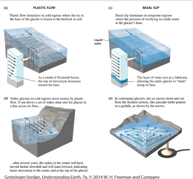
Form when snowfall exceeds summer snowmelt -→ snow compacts into ice
As ice grows thicker, the pressure on the ice increases
Eventually, the ice becomes plastic (loses its rigidity) and flows downhill
Glaciers move slowly due to their own weight and gravity
Glacial movement - Plastic Flow vs Basal Slip
Glacial Shrinkage
Ablation: the total amount of ice that a glacier loses each year
Melting
Iceberg calving
Sublimation
Wind erosion
These days most glaciers are in retreat
Glacial Landscape
Glacial sediment
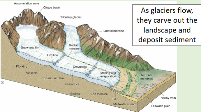
As glaciers flow they erode, transport and deposit material (like a river)
Till: unsorted, unstratified debris deposited on the ground from glacial melt
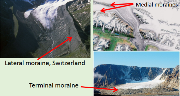
Moraines
A depositional landform
A glacial landform produced by deposition of till
The lower part of the glacier melts, thin
Glacier ends where the rate of glacier movement can no longer keep up with the rate of melt
Alpine (valley) glaciers
Form in mountain ranges, in locations where snowfall exceeds snowmelt
Ice thickens, loses its rigidity, flows downhill
Glaciers erode the landscape where ice meets the ground-along the sides and the bottom of the ice
This creates distinctive landforms at higher elevations
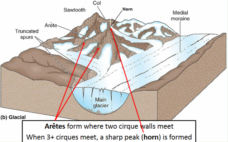
Alpine Glacier Erosional Landforms
Cirque
Aretes
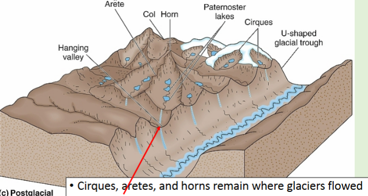
Glacial trough (U-shape)
V-shaped valley
Hanging valley
Cirque form
Amphitheater-like hollow carved at the head of a glacial valley, where snow accumulates.
Example: Tuckerman Ravine, Mt. Washington, former glacial cirque, collects > 50 feet of windblown snow each winter.
Aretes
Form where two cirque walls meet when 3+ cirques meet, a sharp peak (horn) is formed
Examples: Mt. Katahdin, ME (tallest peak in state) “knife edge” route is an arete from past glaciation
Matterhorn, glacial horn on the switzerland / Italy borded
Glaciated valleys
Glaciated valley are U-shaped.
Example: Glacial trough, Austria
V-shaped valley
Formed by fluvial (river) processes, not glacial processes
Hanging valleys:
Where a tributary glacier met the main glaciere, often have waterfalls into the trough
Important facts
Alpine glaciers are relatively small features
Continental glaciers are the largest in the world
Currently restricted to a few areas:
Antartica (90% covered)
Greenland (81% covered)
Smaller ice caps, ice fields found in Iceland, Patgonia region of South America
Continental glaciers have covered much larger areas in the past
Ice shelves
Glaciers usually form on land, but they can flow into the ocean, forming ice shelves. Calving forms icebergs. (For example Iceberg calving off Greenland travel down the east coast.)
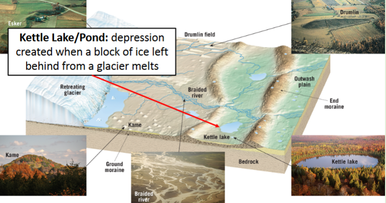
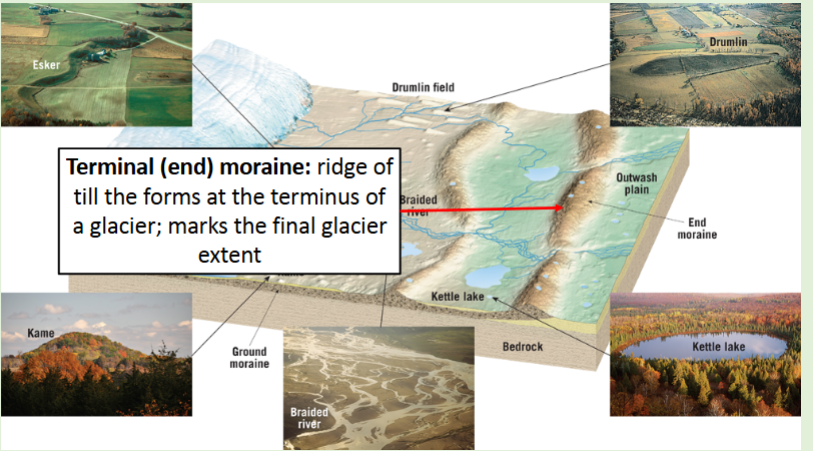
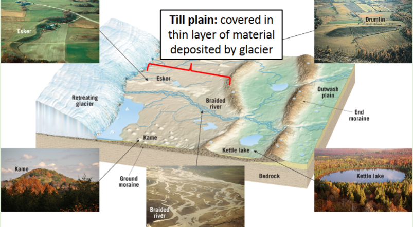
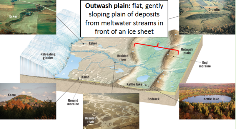
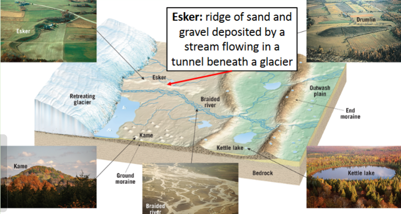
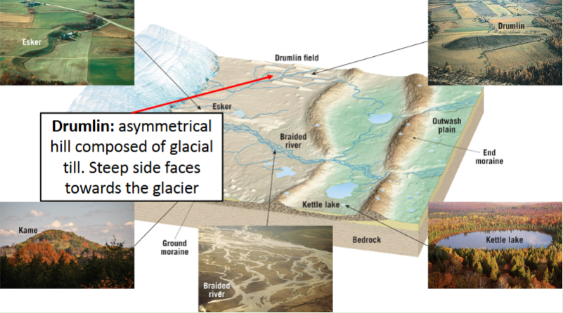
Continental Glacier Depositional Landforms
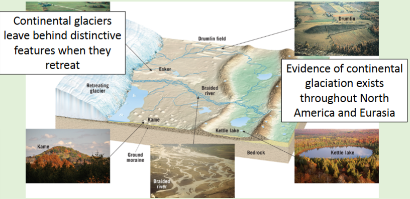
Terminal (end) moraine:
Cape Cod is a giant terminal moraine from the last Ice Age
Till plain
Outwash plain
Esker
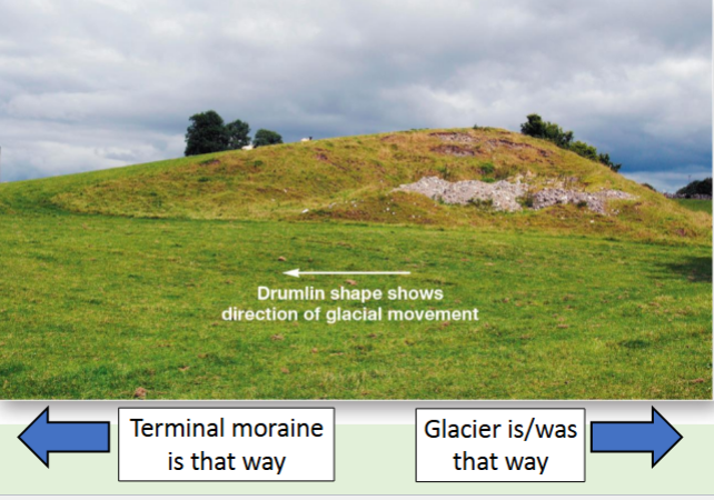
Drumlin
Drumlin shape shows:
Central MA has several drumlin fields
Several near Pine Hill Reservoir
Boston Harbor islands are drumlins
Kettle Lake/Pond