GEOGRAPHY PAPER 1 - Landscapes of the UK
1/53
There's no tags or description
Looks like no tags are added yet.
Name | Mastery | Learn | Test | Matching | Spaced | Call with Kai |
|---|
No study sessions yet.
54 Terms
Sedimentary rock (formation & examples)
Deposition and compaction of sediment under pressure. E.g., skeletons of marine organisms
E.g., Clay, chalk, limestone, sandstone
Igneous rock (formation & examples)
Magma solidifying and having interlocking crystals making it impermeable
Intrusive - cools underground (granite) (large crystals)
Extrusive - cools over ground (basalt) (small crystals)
Metamorphic rock (formation & examples)
Metamorphosis (even more heat and pressure) of sedimentary or igneous rock
E.g., marble, slate
Upland area Definition
> 250m above sea level
Upland area Geology
Resistant, impermeable rocks (less prone to erosion) - igneous rock, e.g., granite. Less resistant rock is weathered away, leaving tors (rocky peak).
Upland area Soil
Short vegetation + thin soil due to little weathering of rocks as they are very resistant. Bracken (type of fern) is only found in upland areas
Upland area Climate
Hot prevailing wind from Caribbean evaporates seawater so the wind picks up moisture towards the upland areas (in the west) where it is pushed up, cooling it, and condensing into a cloud. Cooler air is less able to hold moisture, so precipitation occurs on the windward side of the mountain.
Cold - temperature drops by 1°C for every 100m
Upland area human activity
Harder to settle on but in the past, it was a defensive advantage
- Pastoral farming
- Sustainable forestry - coniferous (can withstand cold)
- Wind turbines
- Hydro
- Reservoirs
- Tourism
- Moors (uncultivated hilly areas) used by military
Lowland area Definition
< 250m above sea level
Lowland area Geology
Less resistant, permeable rock - sedimentary, e.g., chalk, sands & clay
Lowland area Soil
Deep, more productive soil caused by erosion of material and deciduous woodland
Lowland area Climate
Following the rain in upland areas, the air will fall on the leeward side of the mountain, so it warms up but is dry, leaving a rain shadow in the east, so there is less weathering.
Lowland area human activity
- Farming
- Arable possible due to flat land allowing for manoeuvring of machinery
- May require draining of water to improve usability
- Settlement
- Bulk of human activity
Definition of weathering
In situ breakdown of rocks and minerals at the surface (via rainwater, extreme temperature, and biological activity)
Types of Physical weathering & description
- Freeze thaw - During daytime (warm), rain fills a crack in the rock. At night (cold), the water freezes, and the water expands by 9%, applying pressure to the crack and widening it. This repeats until it has fractured into pieces
- Exfoliation - In the desert (wide range of temperatures <0°C-35°C). During daytime (warm), the outside of the rock quickly heats up whilst the inside is still cold, resulting in uneven heating. The same happens during night-time (uneven cooling) and the repeated action of heating and cooling results in layers falling off
Types of Chemical weathering & description
- Carbonation - Carbonic acid occurs naturally in rainwater and reacts with calcitic rocks dissolving them
- Oxidation - iron compounds in the rock react with oxygen to form weaker oxides which can be eroded
Types of Biological weathering & description
- Piddock shells - bore into the rocks by scraping away grains or secreting acid to dissolve the rock
- Burrowing animals - bring rocks up to the surface exposing them to weathering
- Tree roots - prize apart the rock and make holes, increasing the water infiltrating
- Bacteria can produce chemicals to weather the rock so that they can get the nutrients they need
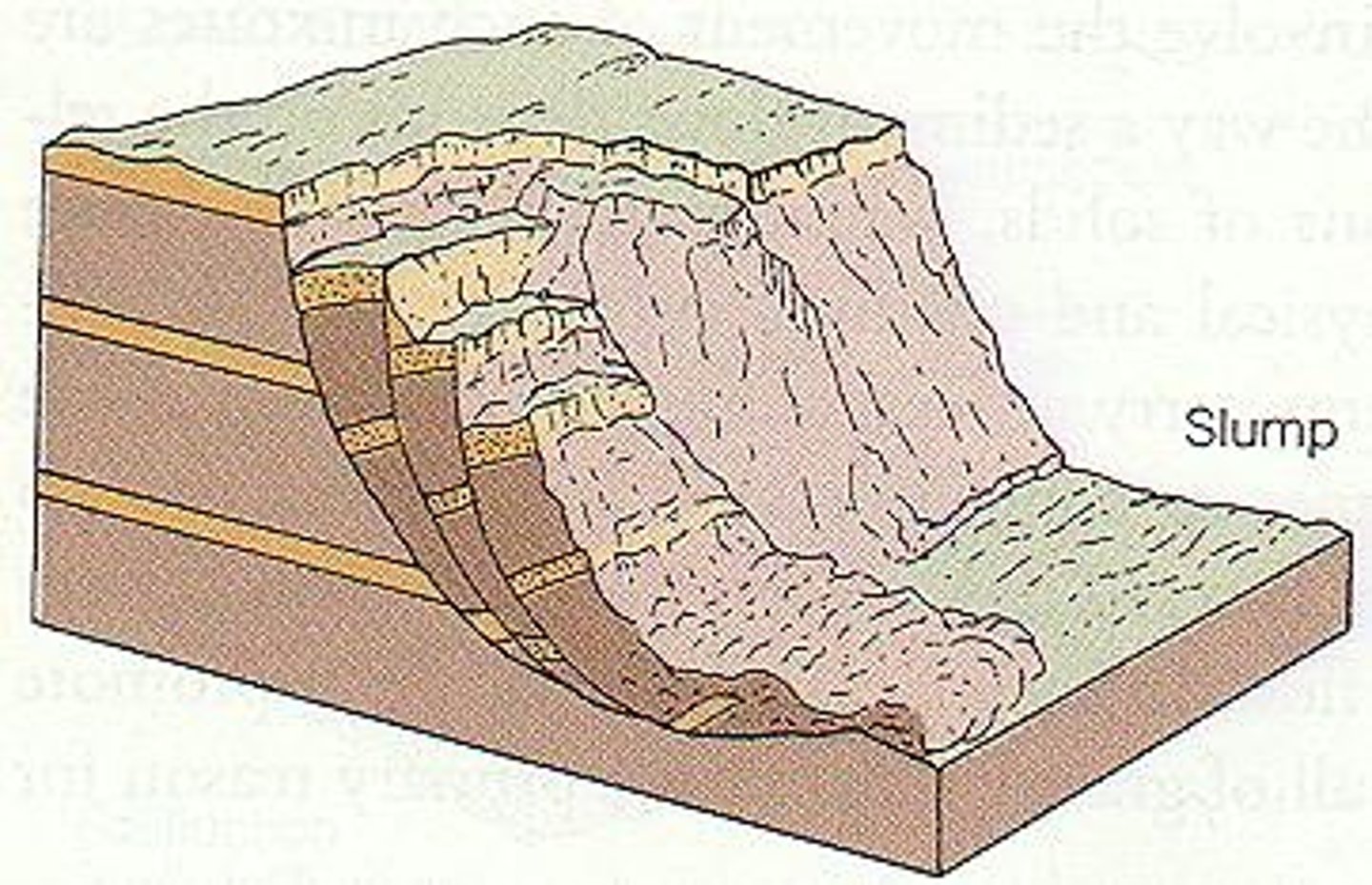
Slumping description
Water infiltrates the soil and builds up on a line of weakness in the cliff = zone of lubrication
This enables the top section to move down the cliff face in a rotational movement due to gravity. The material then accumulates at the bottom of the cliff
Sliding description
Water infiltrates the soil and builds up on a line of weakness in the cliff = zone of lubrication
Waves attack the base creating an undercutting of the cliff. The gap of the wave cut notch means that there is a lack of support for the cliff above, so it moves down the cliff in a straight line
Traction
Rolling of large and heavy rocks along the seabed
Saltation
Smaller (sand-sized) particles bouncing along the seabed
Suspension
Lighter (clay and silt-sized) particles are floating within the sea/river
Solution
Sea water dissolves rock - sedimentary rock like chalk and limestone and carries it
Hydraulic action
Waves force air into cracks to be compressed. Loose rocks are dislodged and removed. When the air retreats the compressed air rushes out of the crack, weakening it.
Abrasion
Sandpaper effect of loose rocks being scraped against the seabed & cliff face
Attrition
Rocks collide with each other causing fragments to fall off ⇒ smaller & rounder
Definition for fetch
distance over which the wind has blown/how far the wave has travelled, ∴ how powerful the wave is
Prevailing wind for the UK
Coming from South-west (from the Caribbean over Atlantic Ocean), and going North East
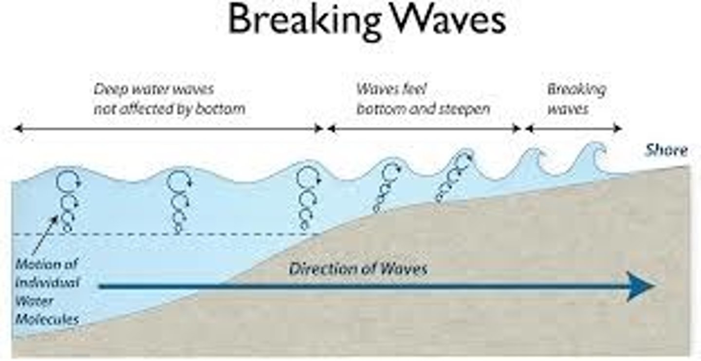
Waves breaking description
1) There is high friction with the wind and surface of the sea causing ripples
2) Waves start out at sea and have a circular orbit (eddy current). As you get shallower, friction with the seabed slows the base of the wave, but the top is moving fast, so the wave arches over and the orbit becomes elliptical
3) The wave then breaks over and plunges onto the beach
4 characteristics of a constructive wave
Create beach ∵ swash > backwash
Short fetch = less energy
Long wavelength & short wave height
Less frequent (6-8/min)

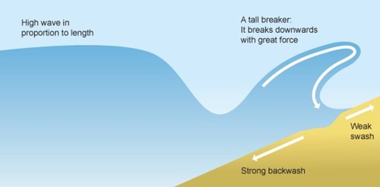
4 characteristics of a destructive wave
Destroy beach ∵ backwash > swash
Long fetch = more energy
Short wavelength & high wave height
More frequent (10-14/min)
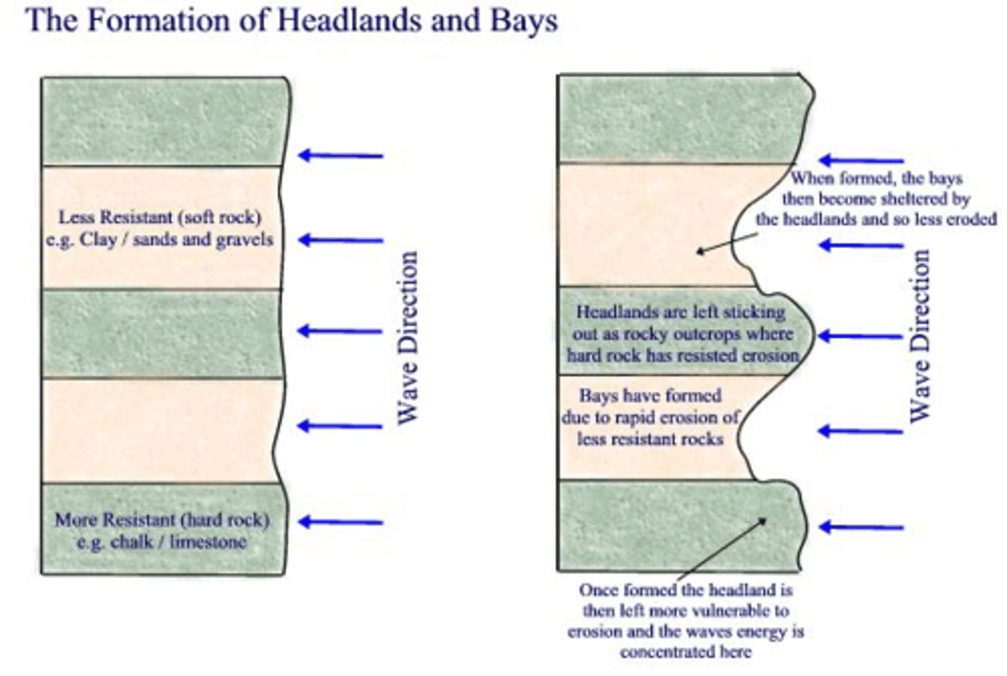
Formation of a headland and bay
- Discordant coastline (bands of rock lie perpendicular to the coastline)
- By hydraulic action & abrasion, less resistant rock is eroded faster, causing the cliff to retreat, and forming a headland and bay
- During calm periods, more resistant rock absorbs wave energy and refracts the now low-energy waves into the bay => deposition of a beach
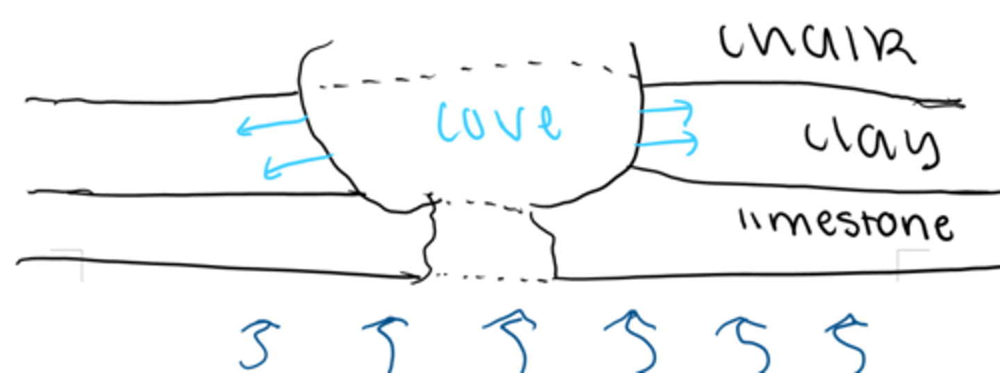
Formation of a cove
- Concordant coastline (bands of rock lie parallel to the coastline)
- Waves exploit a fault line through hydraulic action & abrasion to break through the more resistant rock forming a narrow inlet
- The erosion continues into the less resistant rock which is easily eroded forming a circular/oval shape
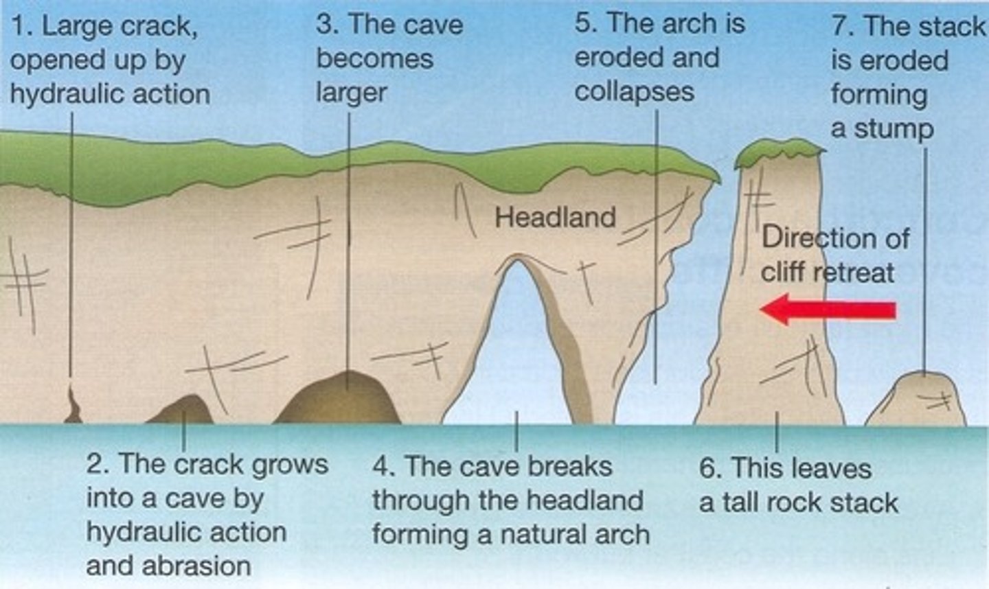
Crack to stump sequence description
1. Waves seek out a weakness in the rock (a fault), opening a crack which allows for hydraulic action enlarging it to form a crevice
2. As the crevice widens from both sides by hydraulic action and abrasion, 2 caves are formed
3. The cave becomes larger by salt crystallisation (salt water evaporates in the cave, leaving salt crystals which apply pressure), hydraulic action and abrasion until an arch is formed (2 caves meet)
4. The top of the arch is weathered by biological processes, making it narrow to the point of collapse forming a stack
5. The base of the stack is eroded by hydraulic action & abrasion to the point of collapse to form a stump
Longshore drift description
Assuming NE prevailing wind:
1) Prevailing wind pushes waves at an angle (45°) towards the shore carrying sediment up - Swash
2) Backwash carries material directly down (90°) due to gravity
3) This forms a zig zag pattern resulting in a net movement of sediment to the east
Formation of a spit
1) Prevailing wind pushes waves at an angle (45°) towards the shore carrying sediment up - Swash
2) Backwash carries material directly down (90°) due to gravity
3) This forms a zig zag pattern resulting in a net movement of sediment to the east
4) Longshore drift continues beyond the coastline, where there is a break.
5) There is deposition in this shallow, calm water.
6) The hooked end forms due to wave refraction and a secondary wind direction. The spit does not extend further as it would be washed away by the fast current in the river estuary
7) Behind it, a salt marsh can form with halophytic (salt tolerant) vegetation as it is flooded frequently
Formation of a tombolo
1) Prevailing wind pushes waves at an angle (45°) towards the shore carrying sediment up - Swash
2) Backwash carries material directly down (90°) due to gravity
3) This forms a zig zag pattern resulting in a net movement of sediment to the east
4) Longshore drift continues beyond the coastline, where there is a break.
5) There is deposition in this shallow, calm water.
6) A tombolo forms as a bridge between the mainland and island due to longshore drift
7) It often becomes submerged at high tide
Formation of a bar
1) Prevailing wind pushes waves at an angle (45°) towards the shore carrying sediment up - Swash
2) Backwash carries material directly down (90°) due to gravity
3) This forms a zig zag pattern resulting in a net movement of sediment to the east
4) Longshore drift continues beyond the coastline, where there is a break.
5) There is deposition in this shallow, calm water.
6) The longshore drift continues across the stream's estuary (weaker current than a river). This is called a bar.
7) Behind the bar, there is a freshwater lagoon
Beach formation
After the mass movement of a cliff falling, it forms a beach, which now protects the cliff as waves have to remove all of the beach to get to the cliff.
Sandy beach's profile and wave forming it
Constructive waves = gentle beach gradient & long beach
Shingle beach's profile and wave forming it
Destructive waves = steep gradient & short beach
Longshore drift vs mass movement's deposited material
- Longshore drift = smooth pebbles
- Mass movement = angular material
Sand dune formation
Onshore wind carries loose sandy material and shingle up the beach. This continues until it reaches an obstruction like driftwood. Once this happens, it forms a sand dune. The sand dune is sheltered from the tide. Vegetation can then start growing. Marram grass copes well here and grows. Eventually bushes grow, whose leaves can make the sand more fertile and can develop into soil.

Characteristics of the Upper Course of River
▫ Material being carried is rough (large bits of rock & soil)
▫ Vertical erosion
▫ Narrow v shaped valley
▫ Rough bed as rock abrades
▫ Slow (friction with bed)
▫ Steep gradient
▫ Waterfalls
▫ Lots of rain
▫ Low discharge
Characteristics of the Middle course of River
▫ Lateral erosion ↑
▫ Vertical erosion ↓
▫ Wider valleys with gentle sides
▫ River starts meandering
▫ Tributaries join river
▫ Confluences ∴ high discharge
Characteristics of the Lower course
▫ Smooth pebbles & small sand particles and shingle carried
▫ Wide & flat valley
▫ Lateral erosion only
▫ Fast (low friction with bed)
▫ Shallow gradient
▫ Oxbow lakes & meanders
▫ ↑ energy to carry more load
What increases as you go along a river?
Discharge
Width
Depth
Velocity
Load
What decreases as you go along a river?
Particle size
Bed roughness
Gradient
V-shaped valley formation
Any spare energy a river has will be used to transport large boulders (traction) along its bed. This results in the river cutting rapidly downwards (vertical erosion) due to the large boulders, carbonation (limestone sides) and solution, freeze thaw weathering (∵ low temperature), and abrasion.
This results in a steep-sided, narrow valley shaped like a 'V' due to loose rock being washed downhill following periods of heavy rainfall ∴ landslides. This material is added to the load of the river which therefore abrades the riverbed even further. The river winds around protruding hillsides - interlocking spurs.
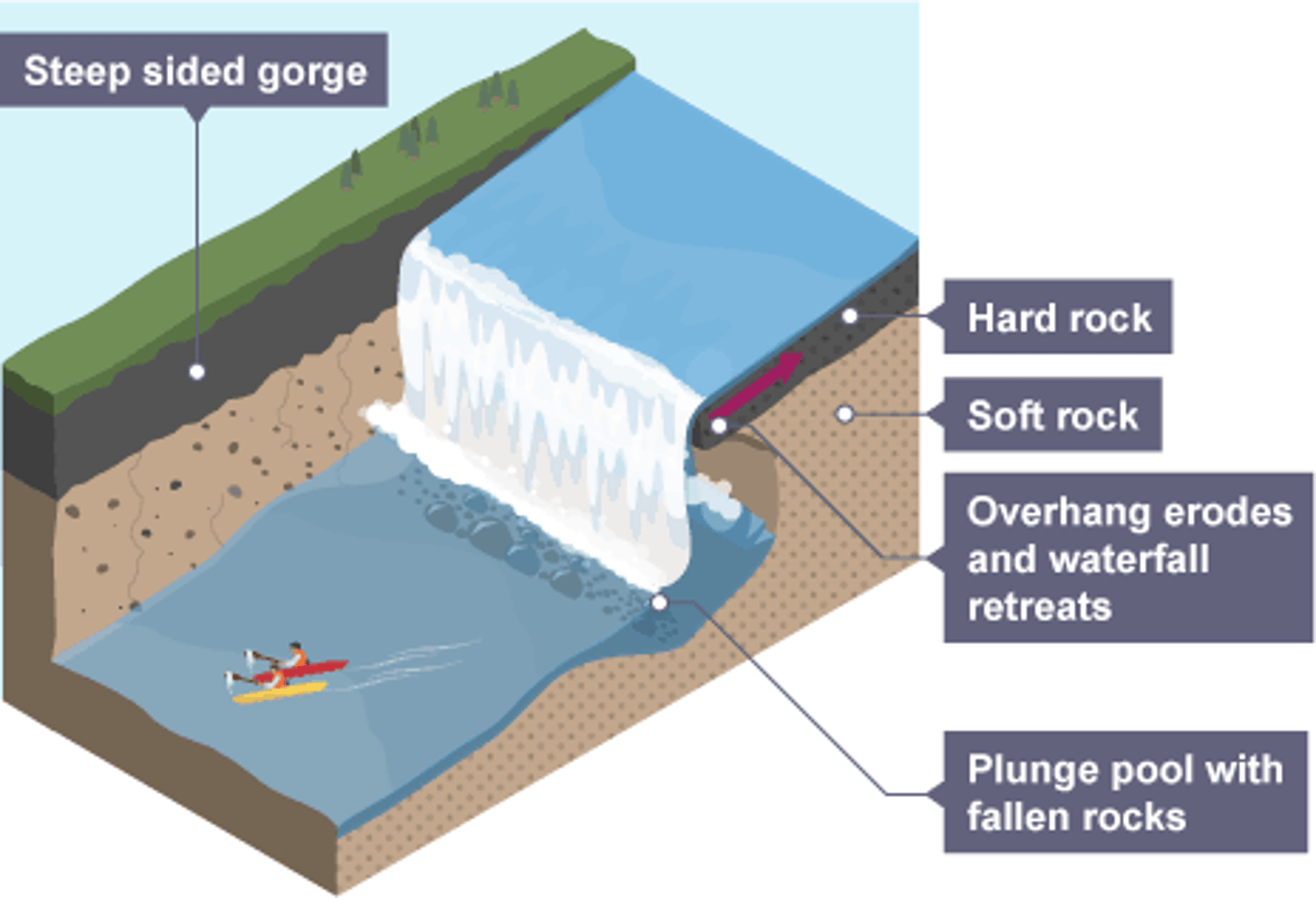
Formation of waterfalls & gorges
1) A band of more resistant rock lies on top of less resistant rock. The river finds weakness in rocks, especially at the knick points (sudden interruptions in the river course) along a river's profile. Falling water erodes the less resistant rock below by abrasion, hydraulic action, and solution (calcitic rocks are dissolved).
2) The resistant rock overhand grows as less resistant rock supporting it is undercut due to the force of water (hydraulic action) and eroded material (abrasion) creating a plunge pool.
3) The eroded material swirls around abrading the bottom and continues undercutting the resistant rock, especially during times of high discharge ∴ the more resistant rock's weight is not supported and so collapses. The waterfall ∴ retreats upstream
4) This retreating of the waterfall leaves steep sided gorges
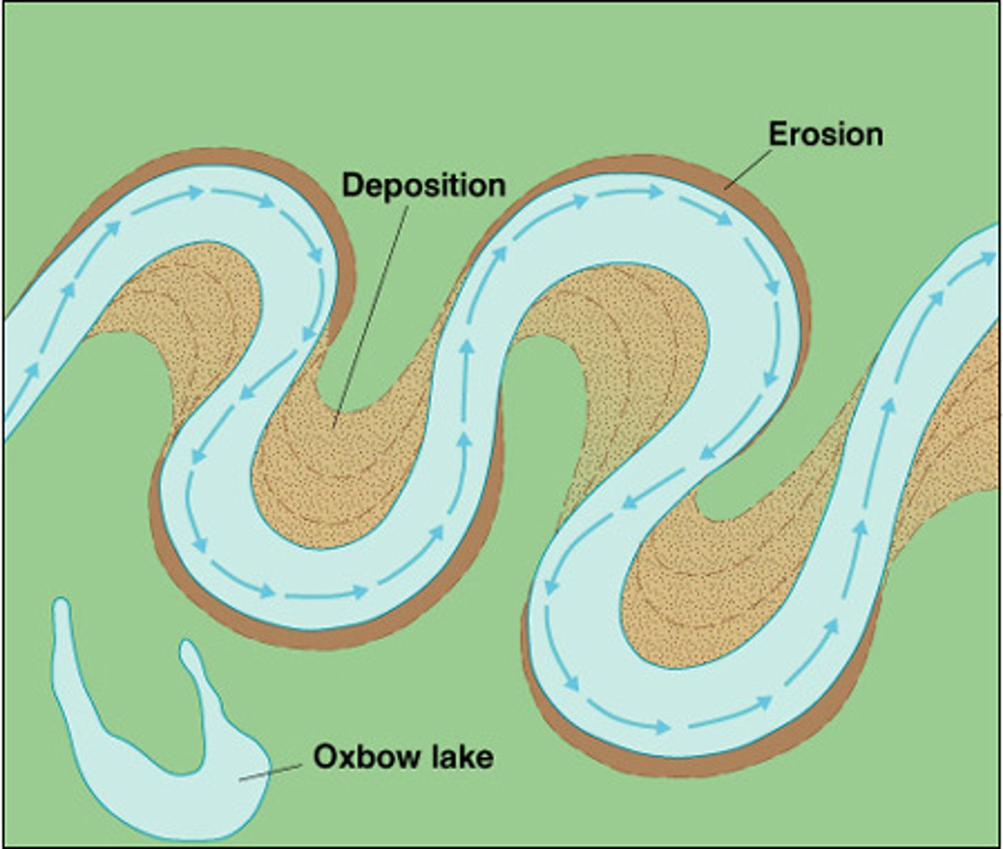
Formation of meanders
1) The river is forced around a hill forming a bend. The river, as it is in the middle - lower course, is fast flowing. There is one line of fastest flow - the thalweg - which is near the outside of bends.
2) This results in erosion of the outside of the riverbed, deepening it to form a river cliff. The inside of the bend has a slower current so there is deposition making a shallow slip off slope. There is a corkscrew-like flow of water - helicoidal flow - moving material from the river cliff and depositing it to the slip off slope.
3) The bending of the meander increases until 2 necks are so close together that there is only a thin stretch of land remaining.
4) The river floods so the water has higher energy and erodes through the thin meander neck. The river then takes the easier straight course, depositing material at the edges blocking the old river course forming an oxbow lake
Floodplain
Area of wide flat land alongside a river in the lower course that is liable to flooding
Levee definition
Large natural embankments close to the channel
Formation of a levee
1) There is lateral erosion while the river meanders helping to make the floodplain. The river stays in its channel.
2) When the river floods, larger sediment is deposited close to the river channel ∵ the river starts to lose energy. Smaller sediment is carried further away and then deposited
3) Layers of sediment cover the floodplain - levees: large natural embankments close to the channel
4) These layers of sediment build up each flood and make the land around fertile - provide minerals for plants & grasses
