Physical Landscapes In The UK
1/8
There's no tags or description
Looks like no tags are added yet.
Name | Mastery | Learn | Test | Matching | Spaced | Call with Kai |
|---|
No analytics yet
Send a link to your students to track their progress
9 Terms
Relief
A term used to describe the highest and lowestpoints in an elevation area
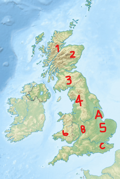
Name regions 1 - 6 and rivers A-C
Northwest Highlands
Grampian Mountains
Southern Uplands
Penines
The Fens
Cambrian Mountains
A. River Trent
B. River Severn
C. River Thames
Where are highland and lowlands areas found in the UK (bullet points)
Highland - Northwest and Central Scotland, Central England, Central Wales
Lowland - South and Southeast England
What is the highest mountain in the UK, how tall is it and what mountain range is it in
Ben Nevis
1344m
Grampian Mountains
What is the highest mountain in Wales, how tall is it and what mountain range is it in
Mount Snowdon
1085m
Snowdonia
The Fens are the lowest area of the UK, how far beneath sea level can the reach
50m
Describe the location of the River Severn
The River Severns source is in mid Wales and flows towards the border with England, then goes south and the mouth is at the Bristol channel
What does the distribution of highland areas tell us about precipation patterns
Highland areas such as Scotland and Wales will experience more precipitation
Describe the precipitation distribution in the UK
Highest - West Scotland, the Lake District, Wales
Lowest - East and South England