Unit 1 AP Human Geography Required Vocabulary (and a few extra)
 Call Kai
 Learn
Learn Practice Test
 Spaced Repetition
 Match
Match Flashcards
 Knowt Play
1/56

There's no tags or description
Looks like no tags are added yet.
Name | Mastery | Learn | Test | Matching | Spaced | Call with Kai | Chat |
|---|
No analytics yet
Send a link to your students to track their progress
57 Terms
absolute location
dictates where a place exists on a reference system; exact and/or specific

cartogram map
a map that displays countries according to some specific characteristic; good for comparing data.

choropleth map
A type of map showing quantity or type of phenomena by area. It uses shades or colors to show class intervals and is often used for maps displaying density.

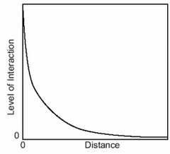
distance decay
The idea that, all else being equal, as the distance between two places increases, the volume of interaction between these places decreases.
Dot map
The specific location and distribution of something across the territory of the map; each dot represents a specified quantity.

Environmental Determinism
The controversial idea, popular in the early twentieth century and largely discredited today, that climate or other physical qualities of an area dictate the culture of the people who live there.
Field observations/field work
Physically visiting a location, place, or region and recording information seen there
Formal Region
Places composed of one or more characteristics in common
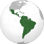
Functional Region
A region formed by places that interact; such as places linked by a commuting pattern or an activity space
Geographic Information System (GIS)
Computer systems that can capture, store, analyze, and output geographic data

Geospatial data
all information that can be tied to a specific place; often gathered by geographers in the field
Geospatial technologies
Satellite imagery, remotely sensed data, GIS, and GPS

Global Position System (GPS)
Receivers on the earth's surface use the location of multiple satellites to determine and record a receiver's exact location

Globalization
The elimination of national boundaries through ever greater integration of people, companies, and governments across the world.

Isoline map
A map that is used to display distributions. It consists of lines that connect points of equal value. Useful for handling continuous data.

Mercator projection
Map projection developed for navigation; it distorts landmasses further away from the equator. Although often criticized, it is still used for navigational purposes.

Perceptual Region (Vernacular)
A region that people construct in their mind, making them difficult to dissect.
Peters projection
Map projection that tries to reflect the the relative surface areas of landmasses, an approach which gives greater prominence (than do standard representations) to equatorial countries

physical map
A map that shows and labels natural features, such as mountains, rivers, and deserts

Place
A basic unit and key concept in geography that indicates where something exists.
Possibilism
The viewpoint that arose as a criticism of environmental determinism, holding that human populations develop their own cultures within constraints set by the environment.

Polar projection (Conic)
a map projection of the sphere in which the point of sight is at the center and the plane of projection passes through one of the polar circles

Political map
a map that shows and labels human-created boundaries and designations, such as countries, states, cities and capitals

Qualitative data
Data that is usually not represented by the numbers; this kind of data comes from interviews, document archives, descriptions, and visual observations

Quantitative data
Data that can be measured and recorded using numbers; examples would be distribution of people by income or age group

Regionalization
the process used by geographers to divide and categorize space into smaller areal units

Reference maps
these maps are designed for people to refer to for general information about places; they include political maps, physical maps, road maps, etc.

Relative location
The location of a place compared to other places.

Remote sensing
The use of cameras or other sensors mounted on aircraft or satellites to collect digital images of the earth's surface
Robinson projection
a compromise map projection showing the poles as lines rather than points and more accurately portraying high latitude lands and water to land ratio

Scale
the ratio between the size of things in the real world and the size of those same things on the map
Site
the characteristics at the immediate location, such as soil type, climate, labor force, and human structures.
Situation
essentially how does where this place is relate to its surroundings; why does a location's situation make it unique, or good for a particular activity?
Space time compression
since the Industrial Revolution, improvements in transportation and communication have shortened the time required for movement, trade or other forms of interaction between two places

Thematic Maps
Maps that show spatial aspects of information or of a phenomenon, including choropleth, dot, graduated symbol, etc.

placelessness
Defined by geographer Edward Relph as the loss of uniqueness of place in the cultural landscape so that one place looks like the next. No connection
Toponym
place name
Human Geography
One of the two major divisions of Geography; the spatial analysis of human population, its cultures, activities, and landscapes.
Spatial Distribution
refers to how resources, activities, human demographics or features of the landscape are arranged across the surface of the Earth
Spatial Relationships /Interaction
the movement of people, goods and ideas within and across geographic space
Spatial Thinking/Analysis
finds meaning in the shape, size, orientation, location, direction or trajectory, of objects, processes or phenomena, or the relative positions in space of multiple objects, processes or phenomena.
Cartography
The science of making maps
Landscape Analysis
process of describing and interpreting the landscape ecology of an area/ generally with the goal of assessing the impact of humans on that space.
Human Environment Interaction
The geographic theme that explores how people use, adapt to, and modify the environment
physical site characteristic
Features including climate, topography, soil, water sources, vegetation, and elevation.
built environment / Cultural landscape
the intentionally designed features of human settlement, including buildings, transportation and public service infrastructure, and public spaces
Patterns and processes
recurring characteristics or events and a series of actions or steps taken in order to achieve a particular end.
graduated symbol map
A map with symbols that change in size according to the value of the attribute they represent.
Mental Map
A representation of a portion of Earth's surface based on what an individual knows about a place, containing personal impressions of what is in a place and where places are located.
topographic map
A map that shows surface features of an area such as mountains, valleys, plains, and plateaus by using contour (isoline) lines to show changes in elevation
Goode Homolosine Projection (Interrupted Projection)
a 20th century map of Earth with equal area of landmasses but interruptions of the oceans to more accurately represent a "flattened" sphere.
geographic model
A model that represents earths features.
region
An area distinguished by a unique combination of trends or features.
Sub-regions
Shares some characteristics with the rest of the larger region but is distinctive in some ways
Online mapping and visualization
the compilation and publication of Web sites that provide exhaustive graphical and text information in the form of maps and databases.
Satellite imagery
images from satellites that orbit Earth
census data
Geospatial data collected through the quantification of a population