unit 4 (earth systems and resources)
1/78
Earn XP
Name | Mastery | Learn | Test | Matching | Spaced | Call with Kai | Chat |
|---|
No analytics yet
Send a link to your students to track their progress
79 Terms
the layers of earth
core, mantle, asthenosphere, lithosphere, and crust
core
a dense mass of solid nickel, iron, and radioactive elements that release massive amounts of heat
mantle
a liquid layer of magma surrounding the core, and it is kept liquified by the intense heat from core
asthenosphere
a solid, flexible outer layer of the mantle, just beneath the lithosphere
lithosphere
a thin, brittle layer of rock floating on top of the mantle, and it is broken up into tectonic plates
crust
the very outer layer of the lithosphere, and commonly referred to as Earth’s surface
divergent plate boundary
a situation where plates move away from each other as a result of rising magma plums
forms mid-oceanic ridges, volcanoes, seafloor spreading, and rift valleys
convergent plate boundary
a situation where plates move toward each other other, leading to subduction
forms mountains, island arcs, earthquakes, and volcanoes
subduction
a situation where one tectonic plate is forced beneath another tectonic plate
transform-fault plate boundary
a situation where plates slide past each other
forms earthquakes, when the tectonic plates are stuck and then quickly slide past each other
convection cycles
a cycle of heating magma that rises up to the surface of the lithosphere, where it cools and expands, spreading out across the lithosphere, before sinking back down into the mantle
oceanic-oceanic convergence
one plate is forced underneath the other, forcing magma up to the lithosphere’s surface, where mid-ocean volcanoes are formed (and later forms island arcs as a result of consistent eruptions)
oceanic-continental convergence
dense oceanic plate is forced beneath a continental plate, and melts back into the magma, forcing the magma up to the lithosphere surface, creating coastal mountains, volcanoes on land, trenches, and tsunamis
continental-continental convergence
once continental place being forced underneath another, forcing surface crust upward, forming mountains
ring of fire
the pattern of volcanoes all around the pacific plate
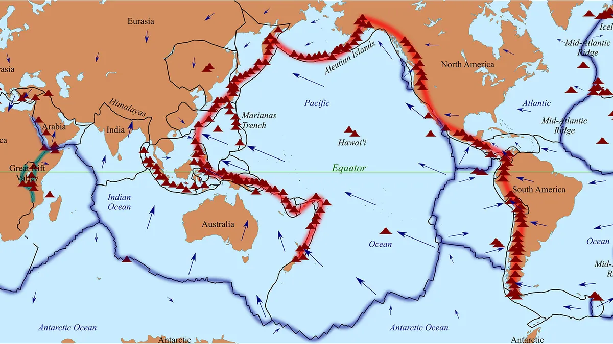
hotspots
areas of especially hot magma rising up to the lithosphere
soil
a mix of geologic and organic components, including: sand, silt, clay, humus, nutrients, organisms, water, and air
humus
the main organic part of soil, and it is broken down biomass like leaves, dead animals, waste, etc.
soil’s role with plants
anchors roots of plants and provides water and nutrients (nitrogen, phosphorus, potassium, and magnesium) needed for growth
soil’s role with water
filters rainwater and runoff by trapping pollutants in pore spaces and plant roots, allowing for clean water to enter groundwater and aquifiers
soil’s role with nutrient recycling
serves as a habitat for decomposers who break down dead organic matter and return the nutrients to the soil
soil’s role with habitat
provides a habitat for organisms like earthworms, fungi, bacteria, etc.
weathering
the break down of rocks physically, biologically, or chemically
erosion
the transportation of weathered rock fragments by the wind and rain
deposition
the final stage of soil formation, after eroding forces carrying weathered rocks to a different location
soil formation from below
the weathering of parent material, which produces smaller fragments that make up the geological portion of soil
soil formation from above
the breakdown of plants and organic matter adding humus to the soil
parent material
also called bedrock, and determines the soil pH and nutrient content
topography
describes the steepness of soil, where a steep slope can lead to too much erosion but a level ground could increase the rate of deposition
climate
can determine the rate of deposition and breakdown of organic matter
warmer climates lead to faster breakdown of organic matter and more precipitation leads to more weathering, erosion, and deposition
organisms
increase the rate of the breakdown of organic matter
o-horizon
a layer of organic matter (plant roots, dead leaves, animal waste, etc.) on top of the soil
a-horizon
also called the topsoil; largely composed of humus and minerals from parent material
has the most biological activity, breaking down organic matter to release nutrients
b-horizon
also called the subsoil; the lighter layer below topsoil, mostly made of minerals with little to no organic matter and minimal nutrients
c-horizon
the least-weathered soil that is closest to the parent material
soil degredation
the loss of the ability of soil to support plant growth
loss of topsoil
commonly caused by tilling, or turning soil for agricultural, and makes it more easily eroded by wind and rain because it is dried out
compaction
the compression of soil by machines, grazing livestock, and humans; reduces its ability to hold moisture, making it erode more easily and supports less plant growth
nutrient depletion
repeatedly growing crops of the same soil, leading to the removal of nutrients over time and reduces the soil’s ability to grow future crops
soil texture
the percent of sand, silt, and clay
pores
the empty spaces between particles in soil
sand has the biggest pores and clay has the smallest pores
porosity
the amount of pore space a soil has
soil with more sand has a higher porosity and soil with more clay has less porosity
permeability
how easily water drains through a soil; water drains easier through high porosity soil
water-holding capacity
how well water is retained, or held, by a soil; more porous soil has a lower water-holding capacity
ideal soil type
sandy loam; balances the porosity and water-holding capacity
soil acidity
determines the nutrient availability
more acidic soil will indicate less nutrient availability
relative abundance of gasses in the atmosphere
nitrogen (78%), oxygen (21%), argon (0.93%), water vapor (0-4%), carbon dioxide (0.04%)
exosphere
the atmosphere’s outermost layer, where it merges with space
thermosphere
the layer of the Earth’s atmosphere that absorbs harmful X-rays and UV radiation
mesosphere
the middle layer of the atmosphere
stratosphere
second layer of the atmosphere, and it is where the ozone layer is found, which is responsible for absorbing UV-B and UV-C rays
troposphere
the layer of the atmosphere closest to Earth, and it is where the molecules are most dense
although there can be ozone in this layer, if ozone is found in this layer it is harmful to humans as it is a respiratory irritant
temperature gradient
the idea that the layers of the Earth’s atmosphere are based on where temperature ranges change with distance from Earth’s surface
troposphere (cold), stratosphere (warm), mesosphere (cold), thermosphere (hot)
hadley cell
the cycle of air circulation between the latitudes 0 degrees and 30 degrees N and S
steps of the hadley cell
more direct sunlight at the equator, warming the air at the equator
warm air rises, cools, and expands, allowing water vapor to condense into rain
air continues to rise, cool, and expand
the cool air expands and spreads out
cool, dry air sinks back to Earth at 30 degrees N and S, often forming deserts because of a lack of moisture in the air
air moves from 30 degrees N and S to 0 degrees as a result of the former latitude having high pressure, meaning that it will flow back to the low pressure (0 degrees latitude)
coriolis effect
the deflection of objects travelling through the atmosphere due to the spin of the Earth
from 0 to 30 degrees latitude, the wind flows from East to West because of the fact that the Earth spins from West to East
from 30 to 60 degrees latitude, the wind flows from West to East because the high speed of Earth at this latitude keeps it in the same direction as the Earth’s rotation
westerlies
the name for the wind pattern from 30 to 60 degrees latitude, North and South
trade winds
the name for the wind pattern from 0 to 30 degrees latitude, North and South, as a result of the Earth’s rotation
watershed
an area of land that drains all water into a specific a body of water; determined by the slope of the land, as ridges can divide these areas of land
effect of vegetation on watershed drainage
can result in more infiltration and groundwater recharge, if it is greater in scale
effect of slope on watershed drainage
can lead to a faster velocity of runoff and more soil erosion, if greater in scale
effect of soil permeability on watershed drainage
determines the runoff and infiltration rates of watersheds
insolation
the amount of solar radiation reaching an area
solar intensity
dependent on the sunrays’ angle, or how directly the rays strike Earth’s surface, and the amount of atmosphere that the rays must pass through
june solstice
the day during which the northern hemisphere receives the most insolation, as a result of it being maximally tilted towards the Sun
december solstice
the day during which the southern hemisphere receives the most insolation, as a result of it being maximally tilted towards the Sun
march and september equinoxes
the days during which the north and south hemispheres are equally facing the Sun
albedo
the proportion of light that is reflected by a surface, and directly affects surface temperature
higher albedo
the reflection of more light, and the absorption of less light
lower albedo
the reflection of less light, and the absorption of more light
urban heat island
urban areas that are hotter than surrounding rural areas, as a result of low albedos on black roadways and tops
rain-shadow effect
warm, moist air from the ocean, after hitting the “windward” side of the mountain, which then rises and cools above the mountain, and finally the dry air descends down the “leeward” side of the mountain, warming as it sinks
windward side of mountains
typically has lush, green vegetation as a result of facing the warm, moist air that comes from oceans
leeward side of mountains
typically experiences arid desert conditions as air descends past the mountain, typically dry after rising and cooling
gyers
large ocean circulation patterns due to global wind patterns; clockwise in the northern hemisphere and counterclockwise in the southern hemisphere
upwelling zones
areas of ocean where winds blow warm surface water away from a land mass, drawing up colder, deeper water to replace it
benefits of upwelling zones
brings dissolved oxygen and nutrients to the surface, often creating very productive fishing environments
thermohaline circulation
a movement of all ocean currents in order to mix salt, nutrients, and temperature throughout all of them
el niño-southern oscillation (ENSO)
the pattern of shifting atmosphere pressure and ocean currents in the pacific ocean between South American and Australia, or Southeast Asia
leads to the regular shifting from el niño (warmer, rainier) to la niña (cooler, drier), along the South American coast