AP Human unit 6 - cities, urban use land use patterns, and processes
1/77
Earn XP
Name | Mastery | Learn | Test | Matching | Spaced | Call with Kai |
|---|
No analytics yet
Send a link to your students to track their progress
78 Terms
What are situation factors in human geography?
Situation factors refer to the location of a place relative to other places and human activities, influencing accessibility, connectivity, and environmental context
What are site factors?
Factors of a specific location (soil fertility, location, lans available, etc.)
How did advancements in transportation effect urban sprawl?
It increased urban sprawl and suburbanization due to increased amounts of goods and services being moved between places
How did urban sprawl effect the environment?
Newly connected cities and settlements lead to increased commute time, which increased individuals reliance on their automobiles and caused more pollution
What is an informal settlement?
An informal settlement is a residential area where housing is not constructed legally, often developing on land that is not owned by the residents, characterized by inadequate infrastructure and services. These occur to the government not being able to keep up with growing urban populations and being able to provide affordable housing
What is the cause of urban growth usually?
Migration, not by natural increase
What is a price ceiling?
Government imposed limit on the price of a product or services (goal is to reduce the price of the product or services)
What is specialization in the context of cities?
Specialization in cities refers to the focus of specific areas or sectors on particular industries or services (manufacturing, tourism, education, etc,) allowing for increased efficiency and productivity within urban environments. It can lead to the development of economic clusters where businesses in related fields benefit from proximity to one another. Factors create a unique sense of place.
What are some effects of developments in transportation?
Allow for people to enter and leave the CBD easily, and also allows them to have access to surrounding settlements and resources. Also allows for people to live further away from the central business district, but have access to the same goods and services
What is the house and growth like in urban areas?
Vertical growth (skyscrapers, high rise apartment buildings) housing has less space (clustered together) and little to no access to greenery.
What are the home and growth like in suburban areas?
Growth is horizontal (long and wide houses, take up larger acres of land) housing is more dispersed, less population density, and has access to greenery. Suburban housing takes up the same space as urban housing, but with less people.
What is a primate city?
A primate city is a city that is substantially larger than any other city in the country, serving as a cultural, political, or economic hub. It typically dominates the urban hierarchy and has a major influence over the surrounding areas. Examples include Seoul and Mexico City
What is an effect of having a primate city in a country?
Is usually the main hub of economic activity in its country, which leads to uneven development and distribution of goods and services across the country.
What is a boomburb?
A boomburb is a rapidly growing suburban area that has developed into a major population center, typically characterized by a significant increase in both housing and commercial developments. Boomburbs often feature extensive services, shopping centers, and amenities, reflecting the characteristics of urban areas while maintaining their suburban identity.
What is an exburb?
An exburb is a residential area located beyond the suburbs, often characterized by lower population density and a more rural or semi-rural environment. Exburbs are typically inhabited by people who commute to urban areas and want connection to the CBD for work while seeking a quieter, more spacious lifestyle, combining aspects of suburban and urban life.
What is an edge city?
An edge city is a significant urban development on the outskirts of a major city (usually by a major beltway or highway) characterized by a concentration of business, retail, and entertainment spaces that provide alternative employment and living options to the central urban area. Edge cities usually emerge in response to suburban growth, featuring office parks, shopping centers, and a high level of accessibility for commuters.
What is urban sprawl?
Urban sprawl refers to the uncontrolled expansion of urban areas into surrounding rural land, characterized by low-density residential development, increased reliance on automobiles, and the extension of infrastructure and services beyond the urban core
What is urban decentralization?
Movement I’d a population away from the traditional core area to peripheral areas — resulting in power and money shifting to the peripheral areas
What causes an increase of boomburbs and exburbs around a city?
development of transportation systems and interstate highways
What is a world city?
A world city, also known as a global city, is a significant urban center that holds a primary position in the global economic system, influencing global and regional affairs. These cities are characterized by their advanced services, cultural diversity, and influence on international finance, trade, politics, and communications. Examples include London, NYC, and Tokyo,
What is the rank size rule?
The rank size rule is a principle in urban geography that describes the relationship between the sizes of cities within a particular urban system. According to this rule, the population of a city is inversely proportional to its rank in the hierarchy; the second largest city will have approximately half the population of the largest city, the third largest will have one third, and so on. This rule helps to predict urban settlement patterns and the distribution of population within an area
What are examples of countries that follow the rank-size rule?
Brazil, Canada, US
What is the gravity model in human geography?
The gravity model in human geography is a theory that predicts the interaction between two places based on their size and distance. It suggests that larger places attract more people and activities, while the closer two places are, the more likely they are to interact
What is Christaller's central place theory?
Christaller's central place theory is a geographical theory that explains the distribution of cities and towns. It suggests that central places (like cities) serve as 'central' hubs for providing goods and services to the surrounding areas. The theory indicates that these places are arranged in a pattern based on their size and the services they offer, with larger cities providing more specialized services to a wider area
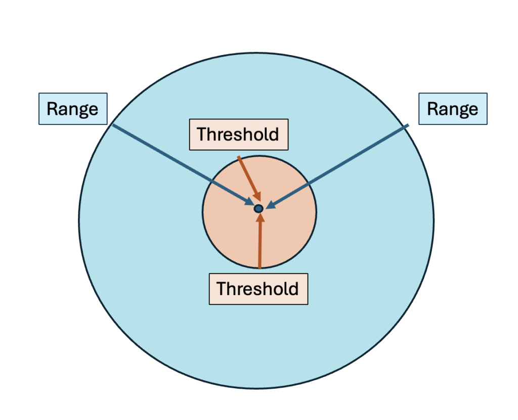
What is threshold?
The minimum number of people that are required to support a good or service

What is range?
The maximum distance a consumer is willing to travel for a certain good or service
What is an example of a business with a small range and a big range?
Small range — Chipotle, Subway (supports small # of people). Large range — football stadiums (can serve population of an entire state)
What is a market or hinterland area in human geography?
A market or hinterland area refers to the geographic region surrounding a central place, from which it draws customers for goods and services. This area is integral for the economic activities of cities, as it represents the trade zone where the demand from consumers supports local businesses, contributing to the overall viability and growth of urban areas.
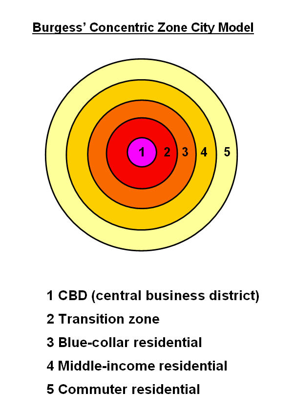
What is the Burgess concentric zone model?
The Burgess concentric zone model is a theoretical urban land use model that describes how cities expand outward from a central point in a series of concentric rings. It proposes that urban areas consist of several zones, each with distinct functions and characteristics, typically including areas for high-density residential, low-density residential, and commercial use, as well as industrial zones. Based off of 1920s Chicago neighborhoods.

What is the Hoyt Sector Model?
The Hoyt Sector Model is an urban land use model developed by economist Homer Hoyt in 1939, which suggests that cities develop in a series of sectors rather than concentric circles, influenced by transportation routes and socioeconomic status. Large focus on economic sectors/activities and transportation.
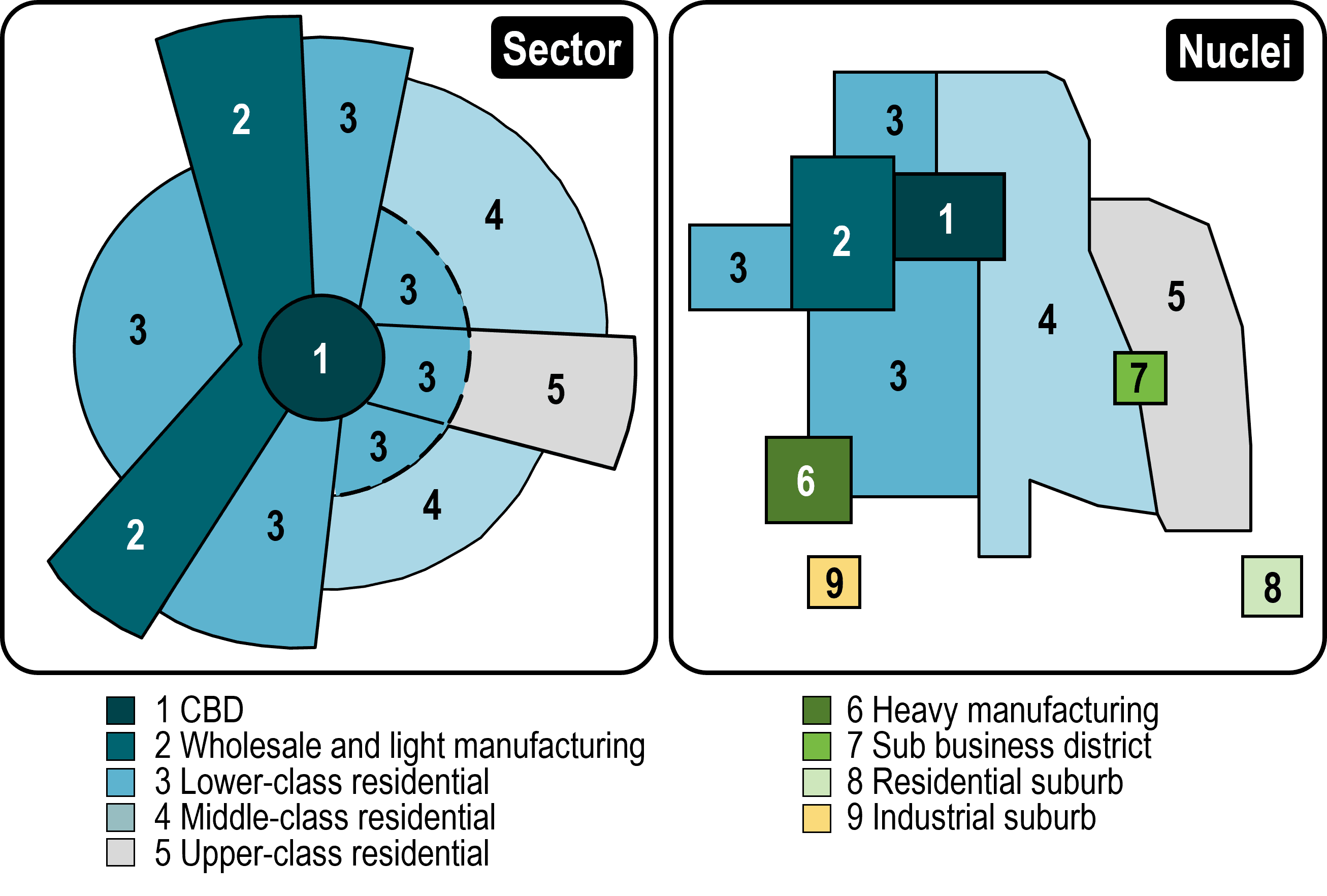
What is the multiple nuclei model?
The multiple nuclei model is an urban land use model developed by Chauncy Harris and Edward Ullman in 1945, which suggests that cities do not grow from a single center but rather from multiple nodes or nuclei. Each nucleus serves a specific function, leading to a more complex urban layout, as different areas develop around various economic activities and institutions. Each node attracted different people and economic activities.
What is the galactic city model?
A model based off 1960’s post industrial cities, where economy is no longer focused on manufacturing. Recognizes edge cities and mixes of different types of homes outside CBD (multi family, single family, and other residential areas). The beltway surrounds the entire city.
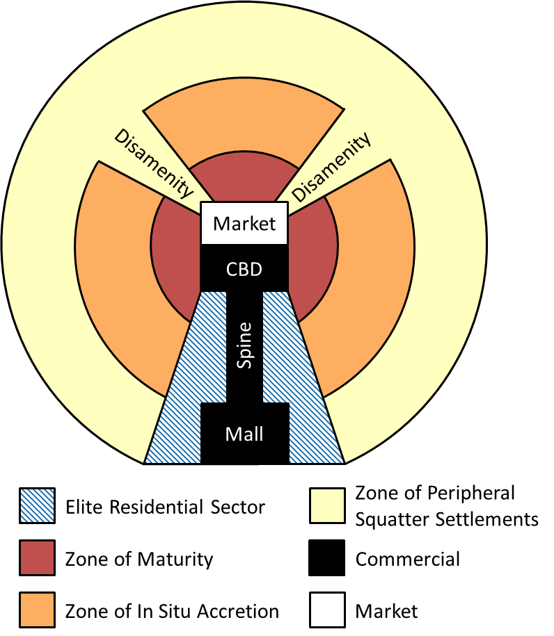
What is the Latin American city model?
The Latin American city model describes the arrangement of urban areas in Latin America, featuring a central business district (CBD) surrounded by a commercial spine, which leads to affluent suburbs. The model highlights the contrast between wealthier neighborhoods closer to the city center and poorer neighborhoods in the outer areas. Showcases impact of European colonization. Zone of maturity is older homes, and situ accretion zones (squatter settlements)
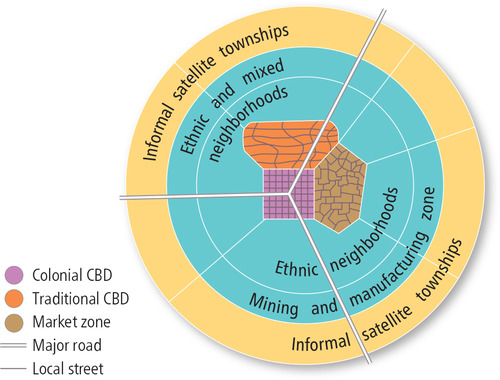
What is the Sub-Saharan African city model?
The Sub-Saharan African city model depicts urban areas characterized by a mix of traditional and modern elements, often with a distinct colonial influence (has a colonial CBD or historic core). It typically features a central business district (CBD) surrounded by residential zones that may include informal settlements. The model is also segregated by mixed and ethnic neighborhoods, which show us the bio story many cities have with colonization and segregation.
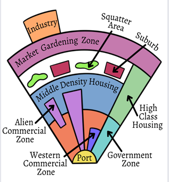
What is the Southeast Asian city model?
The Southeast Asian city model describes urban structures in Southeast Asian cities, characterized by no CBD and being based around port cities in Southeast Asia located on peninsulas or islands. This model often includes a mixture of modern and traditional elements, with residential zones reflecting a diversity of socioeconomic status (not separated by it) and often featuring squatter settlements on the urban periphery. These cities often had zones to stimulate and promote investment from western countries.
What is a density gradient?
Gradual change in the density of an urban area from the center to the periphery
Why do urban areas have more mixed use buildings?
To utilize small amounts of space available with high population density to and to make cities more walkable (residents don’t have to drive to places, since markets and stores are built in the same building as their residential spaces.)
What kinds of housing are available in medium density areas?
Have more of a variety of different types of homes available (townhomes, single family homes, apartments, etc.)
What areas are businesses moving into?
Lower density areas (following there customers and workers to areas with larger range, and smaller threshold)
What is infrastructure?
Refers to the physical and organizational structures and facilities that are needed for a society, system, or organization to function.
What types of infrastructure are necessary to a city?
Power plants, electrical grids, highways, and schools.
How do interstate systems impact urban sprawl?
Increases urban sprawl bevause it allows for people to move out of high density areas into low and medium density areas.
Why do cities need to have good internet connection?
Diffusion of internet changes where people live — allows for cities to support their citizens financially (online banking, telehealth, and online shopping) and increases economic growth bevause people have a access to a multitude of different financial services online.
Why do large cities have more pollution?
Larger cities will have more pollution bevause of their reliance on cars to commute within the city, and long commute distances from people living outside the city in suburbs or exburbs.
What is urban sustainability?
Urban sustainability refers to the development of urban areas in a way that meets the needs of the present without compromising the ability of future generations to meet their own needs. It focuses on creating livable cities that promote environmental health, economic vitality, and social equity
What is social sustainability?
Making sure a city has safe and inclusive communities for all residents by providing affordable housing, education, and healthcare.
What is economic sustainability?
Economic growth that is available to all residents and reduces impact on the environment. Supports small businesses, entrepreneurs, and local development that strives to create socially and environmentally responsible businesses.
What is transit oriented development?
Urban planning that strategically locates public transportation around a city to reduce dependence on automobiles and provide convenient and accessible public transportation options
What are smart growth policies?
Focuses on keeping an urban area compact and walkable
What is a greenbelt?
Undeveloped areas of land set aside for conservation or recreational areas. Traditionally found outside an urban area. Intentionally left underdeveloped to perverse the environment, reduce urban sprawl, and provide a buffer between urban and rural areas. Also increases access to green areas for citizens living inside the city.
What is new urbanism?
Seeks to create compact and walkable cities that are sustainable and socially connected (community oriented cities). Promotes mixed use development, public transportation and green areas. Reflects European urban life, which puts an emphasis on local communities.
What are smart growth policies?
Policies that seek to reduce urban sprawl and protect farmland around the city.
What is de facto segregation?
De facto segregation refers to the separation of groups that occurs in practice, but not as a result of legal requirements or laws. It often arises from social, economic, and residential patterns such as housing discrimination or voluntary choices of individuals and communities.
What is gentrification?
The process of renovating, rebuilding, or revitalizing an urban area, resulting in lower income residents to become displaced as more affluent residents move in.
What are slow growth cities?
Urban areas that promote sustainable growth by limiting development in city periphery (reduces urban sprawl and restores green spaces and areas.)
What are smart cities?
Cities that utilize technology and data to reduce inefficiencies, optimize recourse usage, and improve quality of life for residents. Promotes renewable energy sources
What is redlining?
Redlining is a discriminatory practice in which services (such as mortgages, insurance, or other financial services) are denied to residents of certain areas based on their race or ethnicity. The term originates from the practice of using red ink to outline neighborhoods on maps to indicate areas that were considered risky for investment, often leading to systemic disinvestment and socioeconomic disadvantages for the affected communities.
What was a byproduct of redlining?
It denied communities of color the ability to build generational wealth through home ownerships and other investments,
What is blockbusting?
practice where real estate agents spread misinformation about minority communities moving into neighborhoods to motivate white homeowners to sell their home at a loss so that they can resell at a higher price to minorities.
What is white flight?
A phenomenon in which white residents migrate our of urban areas into suburban areas in large numbers
What is urban blight?
Homes that have close to no value due to being abandoned, vandalized, or stripped
What are environmental injustices?
The disproportionate distribution of environmental hazards among different social groups (margin allied groups are effected more)
What is a disamenity zone?
A disamenity zone refers to areas within a city that are characterized by a lack of basic services, high levels of poverty, and often associated with social or environmental problems. They are typically marked by issues such as crime, pollution, and limited access to infrastructure and resources
What are revitalization programs?
Seek to attract more people back into an area by promoting economic growth and cresting new opportunities for residents
What is an inclusionary zone?
Areas where’s there are local policies in place or incentives for development to create affordable housing for lower income families (create mixed income neighborhoods or housing areas)
What is urban renewal?
Improving or revitalizing deteriorating urban areas or regions.
What is a government bureaucracy?
A government bureaucracy is a system of administration characterized by a hierarchy of authority, a set of established rules and procedures, and a division of labor among specialized departments. It is designed to implement government policies and deliver public services efficiently and effectively. Examples include the Department of Motor Vehicles (DMV), social security administration, and the Internal Revenue Service (IRS) in the United States.
What is eminent domain?
The right of the government to take private property and use it for public use
What is a growth boundary?
Boundary put in place to control urban sprawl
What is a municipality?
Local government units created by a state or national government. (Example- town, village, local gov, unit)
What is an ecological footprint?
An ecological footprint measures the environmental impact of an individual, community, or organization, expressed as the amount of land and water area required to produce the resources consumed and absorb the waste produced, typically measured in global hectares.
What is infill development?
Infill development refers to the process of building new residential or commercial structures on vacant or underutilized land within already developed urban areas. This approach aims to maximize the use of available space, reduce urban sprawl, and enhance community density and accessibility
What are brownfield sites?
Brownfield sites are previously developed lands that are not currently in use and may be contaminated by hazardous substances or pollutants. These sites can result from industrial or commercial activity and require assessment and remediation before they can be reused or redeveloped
What are farmland protection policies?
Farmland protection policies are regulations and strategies implemented by governments to conserve and protect agricultural land from urban development and suburban sprawl. These policies aim to maintain the viability of farming, preserve open space, and promote sustainable agricultural practices.
What is the tertiary sector?
Jobs that offer services to individuals, like teachers or lawyers
What is the secondary sector?
Jobs that involve turning raw resources into a finished product of higher value, like construction workers
What is the primary sector?
Jobs that involve extracting resources from the earth, such as farmers.