L1 Earth history and tectonics
1/22
Earn XP
Description and Tags
AE1106 course
Name | Mastery | Learn | Test | Matching | Spaced |
|---|
No study sessions yet.
23 Terms
Give examples of major infrastructure projects in Sweden where geological and geotechnical knowledge is important. In what way is this knowledge used?
Stockholm blå linje tunnelbana. västlänken, north botnia line, relocation of Kiruna, stockholm E4 bypass, markbygden windfarm.
it’s used in order to understand ground conditions, predit and mitigate risks, and design safe, durable and cost-effective structures in both rock and soil.
ex. västlänken: crucial for tunneling through both rock and very soft clay, knowledge is used to design deep excavations, control settlement, protect old buildings, manage groundwater and build stable underground stations
How has land use been impacted by geology? Give some examples
Geology has a direct impct on how land is used, because soil type, bedrock, groundwater and geological hazards either enable or limit what can be built or cultivated.
ex. fertile soils (clay plains in Skåne) are used for intensive farming while thin soils over granite/gneiss (småland) → poor farming conditions → histroically forests and grazing land instead.
Stable bedrock → allows hydropower dams (eg nothern sweden rivers)
Large, windy plateaus with good bedrock → wind farms
limestone and gravel deposits → shape where cement plants, quarries and road-building industries are located
Soft clay areas → limit high-rise construction
flat coastal plains → urban development and transport corridors
List the 3 main ground surface conditions found across Sweden (e.g. what basic category of rock or soil). What is most common for the Stockholm area? How does this compare to an area such as Skåne?
bedrock: mostly precambrian crystalline rocks (granite, gneiss etc.), exposed or thinly covered in large parts of central and northern sweden.
Glacial deposits (till): unsorted mix of clay, sand, gravel and boulders left by the ice sheet. Covers much of Sweden outside the bare mountain areas.
Postglacial sediments (e.g clay, sand, peat): clay in old seadbeds (mälaren, göta älv, skåne), sand & gravel in eskers and deltas (important for groundwater), peat &gyttja in wetlands
Stockholm: Precambrian bedrock (gneiss and granite), often exposed at the surface.
Skåne: thick cover of sedimentory rokcs, widespread fetile glaical and postglacial clays → excellent farmland, much more continous soil cover → better for agriculture but can be problematic for heavy constructions.
Give some applied examples where a good understanding and prediction of climate change is important in terms of the Swedish society, e.g. strategies for disaster risk reduction
Flood risk & water management
Stockholm slussen partly driven by the need to regulate water levels between Mälaren and Baltic Sea. Important to understand/predict climate change → heavier rainfall and rising sea levels → increased risk of flooding in lower areas around Mälaren (eg central sthlm). This project aims to handle future extreme weather and secure drinking water supplies.
Coastal protection & sea level rise
Southern and western SWE vulnerable to storm surges and sea-level rise. Climate change →increased storm intensity + higher sea levels = greater risk of coastal flooding and erosion → plans to build sea walls, raised quays and buffer zones; land-use planning restricts building in flood-prone areas
Landslides in clay areas
göta älv valley north of gbg: sensitive clays are widespread. Heavier rainfall and higher groundwater levels (climate change) destabilize slopes → increased landslide risk. Ongoing stabilisation projects (eg reinforcements, drainage systems), hazard mapping,)
Forestry & Wildlfires
ex. the 2018 wildfires in Sweden = among the worst in modern history. Warmer drier summers increase wildfire risk, especially in central and northern Sweden where forestry is a major industry → need for better fire monitoring systems, investments in aerial firefighting and forest management (controlled burning, mixed-species planting)
Melting permafrost and ground stability in the North
Kiruna, Gällivare and mining regions in Norrbotten experience thawing permafrost →undermines building foundations, transport routes and mining infrastructure → need for redesigning of infrastructure so that it’s more suitable for unstable ground, monitoring permafrost and shift in construction practises.
Agriculture and Food security
climate change alters what crops can grow, lenght of growing seasons and risks of pests/diseases → good to know so that we can develop climate-resilient crops, irrigation planning and sustainable water use.
What types of extreme weather phenomenon are we seeing more commonly in Sweden within the last decade?
forest fires, hotter and drier summers →increase in frequency and intensity
heatwaves
flooding & heavy rainfall, urban flooding and river floods
reduced snow and ice cover, milder and shorter winters
storm and extreme wind events
Where in Sweden is the highest risk from sea level rise?
The highest risk areas are in southern and southwestern Sweden (Skåne, Halland, Blekinge, Göteborg, and Kalmar coast) where post-glacial rebound no longer offsets global sea level rise.
To manage many of our natural resources in Sweden we need good geological knowledge. Give an example of this
Need to manage pollution of lakes + ground water e.g. both hydrology and hydrogeology knowledge needed
Environmental impact assessment
Old sites need to be dealt with e.g. nature-based solution (nature lakes or wetland in areas of former mines/quarries)
Name and define the two concepts of Earth history
Catastrophism:
Assumption: great effects require great causes.
Earth history dominated by violent events
Uniformitarianism:
Assumption: we can use cause and effect to determine causes of past event. eg. geologic processes are the same today as they were in the past.
Finding: earth history dominated by small-scale events typical of the present
Catastrophes do happen but are uncommon
The present is the key to the past (eg fossils)
What is the difference between “absolute” and “relative” dating?
Absolute = know dates
glaciers left Sthlm about 11 000 years ago, KTH was established 1827
Relative = know order of events but not dates
napoleonic wars happened before WWII
bedrock in Sweden formed before glaciers came
Can you name 3 principles of relative dating?
Law of superposition
In undeformed sedimentary rock layers, the oldest rocks are at the bottom, and each layer above is progressively younger.
Principle of original horizontality
Sediments are originally deposited in horizontal or nearly horizontal layers.
If layers are tilted or folded, it happened after deposition.
Principle of cross-cutting relationships
A geologic feature (fault, intrusion, dike) that cuts across another rock body is younger than the rock it cuts.
Principle of Inclusions
If a rock contains fragments (inclusions) of another rock, the inclusions must be older than the host rock.
Example: A granite containing sandstone fragments → the sandstone is older.
Principle of Lateral continuity
Sedimentary layers extend laterally in all directions until they thin out or meet a barrier.
Even if a valley cuts through a rock layer, we assume the layer originally extended across the gap.
In geology what is an “unconformity”?
An unconformity is a surface in the rock record that represents missing geological time.
It forms when older rocks are eroded or when sediment is not deposited for a long period, and then new sediments are deposited on top.
In other words, it’s a gap in Earth’s history preserved in the rocks.
They reveal past geological events: uplift, erosion, tectonics, sea-level changes.
They show us that Earth’s history is not continuous — parts are missing.
They help geologists correlate rock layers and reconstruct environments through time.
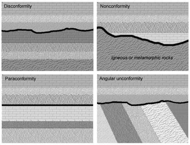
Main types of Unconformities?
Angular Unconformity
Older rocks are tilted/folded and eroded.
New, flat sedimentary layers are deposited on top.
Shows that tectonic activity (uplift & folding) happened before the younger rocks were laid down.
Disconformity
Both the rocks above and below are parallel sedimentary layers.
But the surface between them represents a long period of erosion or non-deposition.
Harder to see because the layers look conformable.
Nonconformity
Sedimentary rocks deposited directly on top of eroded igneous or metamorphic rocks.
Shows a big contrast in rock type, meaning a long gap in geological history.
Paraconformity
Similar to a disconformity, but with no visible erosion surface.
Recognized only by dating or fossil evidence (time gap is hidden).
What is an “index fossil”?
An index fossil is a fossil species that helps geologists determine the age of rocks because it was short-lived, widespread, abundant, and easily recognizable.
Geologists use index fossils to:
Identify and correlate rock layers (strata) across different locations.
Determine relative ages of rocks.
How old is Earth?
Earth is about 4.54 billion years old (± 0.05 billion years).
Determined mainly by radiometric dating of the oldest meteorites, the Moon, and Earth’s oldest rocks.
The oldest minerals on Earth (zircon crystals from Australia) are about 4.4 billion years old.
The oldest rocks in Sweden (in Norrbotten) are around 2.7 billion years old.
What is the age limit for radiocarbon dating? (or what is the oldest ages we can get from radiocarbon dating)
Radiocarbon dating (C-14) can be used to date materials up to about 50,000 years old.
Why this limit?
Carbon-14 has a half-life of 5,730 years.
After ~8–10 half-lives (≈ 50,000–60,000 years), the amount of C-14 left is so tiny that it’s very hard to measure accurately.
What is radioactive decay?
Radioactive decay is the spontaneous breakdown of unstable atomic nuclei into more stable forms, releasing energy (radiation) in the process.
Some elements exist in unstable isotopes (called parent isotopes).
These transform into more stable isotopes (called daughter products).
The process occurs at a predictable rate known as the half-life..
Why is this important in geology?
It is the basis of radiometric dating, which allows geologists to determine the absolute ages of rocks, fossils, and Earth itself.
Different isotopes are used for different timescales (e.g., C-14 for recent, U-Pb for very old rocks).
What is the principle of radioactive dating?
Radiometric (radioactive) dating is based on the fact that:
Radioactive isotopes (parents) decay into stable daughter isotopes at a constant and measurable rate.
This rate is described by the half-life (the time it takes for half of the parent atoms to decay).
By measuring the ratio of parent to daughter isotopes in a mineral or rock, geologists can calculate the absolute age of the sample.
Example
If a rock originally had 100% parent isotope:
After 1 half-life → 50% parent, 50% daughter.
After 2 half-lives → 25% parent, 75% daughter.
After 3 half-lives → 12.5% parent, 87.5% daughter.
By comparing today’s ratio, we can work out how much time has passed since the rock/mineral crystallized.
What is “plate tectonics”?
Plate tectonics is the theory that Earth’s lithosphere is divided into rigid plates that move over the asthenosphere, and whose interactions at plate boundaries cause earthquakes, volcanoes, mountain building, and other geological processes. Driven by internal heat and convection
What type of evidence was used to show the movement of tectonic (lithospheric) plates?
Fit of the Continents
Coastlines of South America and Africa match like puzzle pieces.
Suggested they were once joined (Pangaea).
Fossil Evidence
Identical fossil species (plants & animals) found on continents now separated by oceans.
Example: Glossopteris (seed fern) in South America, Africa, India, and Antarctica.
Rock and Mountain Correlations
Similar rock types and mountain ranges found on different continents.
Example: Precambrian rocks in West Africa and Eastern South America.
Paleoclimate Evidence
Traces of past glaciations in places that are now tropical (e.g. India, Africa, South America).
Coal and reef deposits in areas that are now cold, showing continents were once at different latitudes.
Paleomagnetism (Magnetic Evidence in Rocks)
Iron-rich minerals in cooling lava record Earth’s magnetic field.
Stripes of alternating magnetic polarity on the ocean floor proved seafloor spreading.
Age of the Ocean Floor
Oceanic crust is very young (<200 million years), while continental crust is much older.
Symmetrical age patterns around mid-ocean ridges confirm new crust is created there.
Distribution of Earthquakes and Volcanoes
Most occur along plate boundaries, marking active movement.
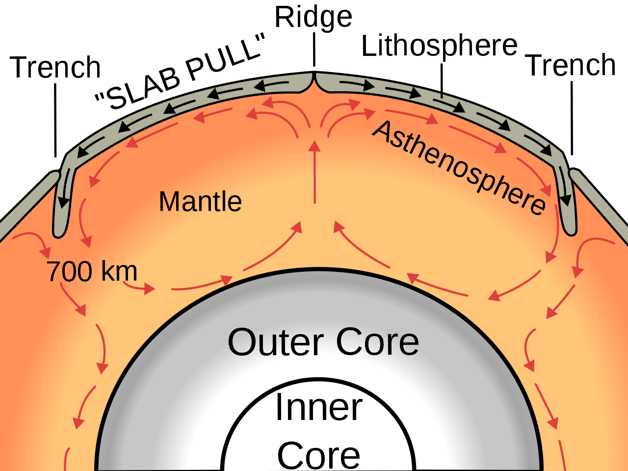
What is the broad mechanism that causes tectonic (lithospheric) plates to move?
The movement of tectonic (lithospheric) plates is driven by heat from Earth’s interior.
Heat causes mantle convection: hot, less dense rock rises; cooler, denser rock sinks.
This slow circulation in the mantle acts like a conveyor belt, moving the rigid plates on top.
Main Forces at Work
Mantle Convection Currents
Flow of solid but plastic mantle material drags plates along.
Slab Pull
At subduction zones, cold, dense oceanic plates sink into the mantle and pull the rest of the plate with them.
Ridge Push
At mid-ocean ridges, new hot crust forms, pushing plates apart due to gravity sliding down the elevated ridge.
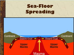
What is “seafloor spreading”?
Seafloor spreading is the process by which new oceanic crust is created at mid-ocean ridges and gradually moves away from the ridge, causing the ocean floor to widen.
How it works:
Magma rises from the mantle at mid-ocean ridges (divergent plate boundaries).
When magma cools, it forms new basaltic ocean crust.
As more magma rises, the older crust is pushed outward, away from the ridge.
This process continuously recycles oceanic crust (the oldest ocean floor is <200 million years old).
Key evidence:
Magnetic stripes: Symmetrical patterns of reversed and normal magnetic polarity on either side of ridges show that new crust formed as Earth’s magnetic field flipped.
Age of ocean floor: Rocks are youngest at the ridge and get progressively older away from it.
Heat flow: Highest at mid-ocean ridges.
Where are the oldest rocks found? In the ocean basins or on land?
The oldest rocks are found on land (continental crust). canada and greenland
Oceanic crust is always younger (<200 million years), while continental crust preserves rocks that are billions of years old.
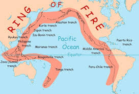
In geology, what does the “Ring of Fire” refer to?
The Ring of Fire is the tectonically active belt surrounding the Pacific Ocean, characterized by frequent earthquakes, volcanic eruptions, and mountain building.
Why so active?
The Pacific Plate and surrounding smaller plates are mostly convergent and transform boundaries.
Processes include:
Subduction zones → oceanic crust sinking beneath continental crust (e.g., Andes, Japan).
Volcanic arcs → chains of volcanoes formed above subduction zones.
Earthquakes & tsunamis → caused by massive plate movements.