Ling Zhang Human Geography Final
1/122
Earn XP
Description and Tags
Concepts from Chapters 10-13 for Ling Zhang's Human Geography Final at University of Central Arkansas
Name | Mastery | Learn | Test | Matching | Spaced | Call with Kai |
|---|
No analytics yet
Send a link to your students to track their progress
123 Terms
Megacity
A metropolis that has a population of 10 million or more people.
Conurbations
When separate major urban complexes expand along the transportation facilities, they may eventually meet and bind together at their outer margins and create extensive urban regions.
Megalopolis
A nearly continuous urban string that stretches from north of Boston to south of Washington, D.C.
Sedentary Agriculture
Dating from at least 8,000 years ago, cities originated in and diffused from the culture hearths that first developed.
Agricultural Surpluses
The earliest cities developed on the creation of ___.
Nonagricultural Work
The main distinction between the city and countryside stemmed from the ___ of most urban dwellers.
Nature of Cities:
All cities must have an economic base to generate the income necessary to support themselves.
Each city is a unit in a system of cities and a focus for a surrouding rural area.
Each urban unit has an orderly internal arrangement of land uses, social groups, and economic functions.
All cities have experienced problems of land use, social conflict, and environmental quality.
Basic Sector
Part of the employed population of a city engaged in the production of goods or the performance of services for areas and people outside of the city. These are “export” activities that bring money into the city.
Nonbasic Sector
Other workers engaged in producing goods or services for the city itself. They don’t generate new money for the city, but they circulate money within the community and are responsible for the internal functioning.
Equation for the Total Economic Structure of an Urban Area
The sum of its basic and nonbasic activities.
Relationship Between Basic and Nonbasic Workers:
As a settlement increases in size, the number of nonbasic personnel grows faster than the number of basic workers.
Multiplier Effect
A city’s employment and population grow with the addition of nonbasic workers and dependents as a supplement to new basic workers.
Functional Categories of Cities:
Transportation Centers
Special-function Cities
Central Places
Transportation Centers
Cities along sea coasts, major and minor rivers, canals, or railways.
Special-function Cities
Cities that serve a specific function (e.g. mining or manufacturing).
Central Places
Cities that function as nodes for the distribution of economic goods and services to surrounding nonurban populations; they have rural service and trade function as their dominant role.
Central Place Theory (pattern)
Walter Christaller developed this theory to explain the observed settlement size and spacing regularities.
This pattern shows a “nesting” of complementary regions which part or all multiple lower service areas are contained within the market area of a higher-order center.
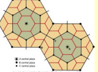
Central Place Theory (definition)
A pattern of interdependent small, medium, and large towns that together could provide the goods and services needed by a dispersed rural population.
Small towns serve as marketplaces for frequently required “low-order” commodities and services, while expensive “high-order” luxury goods would be available only in large communities that were central to surrounding small towns.
Urban Hierarchy
The ranking of cities based on their size and functional complexity.
World Cities
Large urban centers that are command and control points for the global economy.
Rank-Size Rule
The nth largest city in a national system of cities will be 1/n the size of the largest city.
Hint: the variable n is the same number in both places.
Primate City
A city that is more than twice the size of the second ranked city.
Examples: Luanda, Angola; Nairobi, Kenya; London, United Kingdom; Paris, France; Seoul, South Korea; and Bangkok, Thailand.
What Defines a City versus a Town
City and town denote nucleated settlements with multiple functions, including an established central business district and both residential and nonresdential land uses.
Towns are smaller in size and have less functional complexity than cities, but they still have a nuclear business concentration.
What Defines a Suburb
Suburb implies a subsidary area, a functionally specialized segment of a larger urban complex.
What Defines a Central City
A central city is the principal core of a larger urban area, separately incorporated and ringed by its dependent suburbs.
What Defines an Urbanized Area
An urbanized area is a continuously built-up landscape defined by building and population densities with no reference to political boundaries.
What Defines a Metropolitan Area
A metropolitan area is a large functional entity containing several urbanized areas, discontinuously built but operating as an integrated economic whole.
Regional Differences in Urban Land Use
Oldest parts of eastern cities (e.g. Old Quebec and Boston’s Beacon Hill) display remnants of a walking city.
Cities in the East and Midwest (e.g. Philadelphia and Chicago) have large areas developed when mass transit was the dominant mode of transportation.
New cities in the West and Southwest and suburban growth areas of older cities are influenced primarily by automobile travel.
Features of the Central Business District
Highest rental and purchase prices
The intersection where the major mass transit lines converged was called the peak land value intersection.
Department stores and other retail outlets.
Tall office buildings and principal hotels.
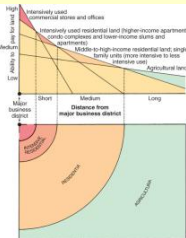
Features Outside of the Central Business District
Land use gradually changes into industrial, lower-order, commercial, residential, and eventually agriculture.
Lower-order commercial centers developed at the outlying intersections of the mass transit network.
The least accessible locations left for the low-density residents.
Automobile-Based Patterns
Wealthy and middle-class families moved away from the city center beginning in the 1940s.
The compact older mass transit city changed and succeeded by low-density, unfocused urban and suburban sprawl of the automobile city.
Models of Urban Form
Concentric Zone Model
Sector Model
Multiple-Nuclei Model
Peripheral Model
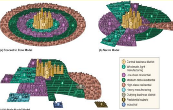
Concentric Zone Model
Describes the urban community as a set of nested rings at increasing distances in all directions from the central business district.
Sector Model
Focuses on transportation access. High-rent residential areas are dominant in city expansion and grow outward along major transportation routes.
Multiple-Nuclei Model
Used for large cities developed from the peripheral spread of several nodes of growth, not just one.
Peripheral Model
Takes into account the urban changes after WWII and focuses on the peripheral beltway that lies within a metropolitan area but outside of the central city itself.
Functions of the belt comminities aren’t defined by their relationship with the central business district, but to other parts of the periphery.
Much of a resident’s life takes place outside of the central city.
Social Status
Defined by income, education, occupation, and home value.
Patterns of social status agree with the sector model.
Persons per room is a good indicator of social status.
Social status divisions are often perpetrated by political boundaries.
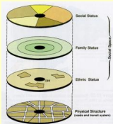
Family Status
As distance from the city center increases, average adult age declines and family sizes increase.
Empty-nesters and young singles tend to live closer to the city center.
Younger families with children tend to live farther from the city center.
Ethnic Status
Areas of a single ethnic group appear as separate clusters or nuclei
For some ethnic groups, cultural segregation is both sought after and vigorously defended
Certain ethnic groups have had segregation forced upon them
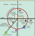
Edge Cities
Defined by large nodes of office and commercial buildings and characterized by having more jobs than residents.
Central City Decline
Eroded accessibility of central cities
Population moved out
Jobs and functions dispersed into fringes
Abandoned by industry and service.
Gentrification
The rehabitation of housing in the older, deteriorating inner-city areas by middle and high-income groups.
Welcomed as a positive, privately financed force in the renewal of depressed urban neighborhoods.
Criticized for serious negative social and housing impacts on the low-income minority families that are displaced.
Characteristics of Western European Cities
High-density and apartment dwelling
Developed for pedestrians and retained compactness appropriate to walking
Importance of public transportation
Worl
Compact with high buldings and population densities.
Nearly universal apartment dwelling
Heavily depends on public transportation
Self-contained residential areas.
Squatter Settlements
Influences from the past (legacy of colonialism)
Underdevelopment of urban facilities
Neighborhoods hastily built by migrants, away from city services and occupying land illegaly.
Government responds with drastic remedies (i.e. moving the national capital from the primate city to a new location)
Development vs. Underdevelopment
Development: high levels of industrialization, advanced technology, diverse economies, high GNI per capita. High levels of access to education, healthcare, clean water, sanitation, and gender equality. Low infant mortality rate and high life expectancy. Stable and usually democratic governance with active participation by citizens.
Underdevelopment: Heavy reliance on primary sector, low levels of industrialization, limited and outdated technology, low GNI per capita, high poverty, and vulnerable to fluctuations in the global economy. Limited access to good education and healthcare, poor sanitation and clean water access, gender inequality. High infant mortality rates and low life expectancy. Sometimes unstable government with high corruption and limited citizen participation.
Newly Industrializing Country
A nation whose economy has transitioned from primarily agricultural to one increasingly based on manufacturing and industrial activities. Experiencing rapid economic growth, often driven by exports, and significant social changes like urbanization and a larger middle class.
Emerging Economy
A developing country that is industrializing and integrating into the global market. The preferred term over third-world.
Transition Economy
A country in the process of shifting from a planned economy to a market-based economy.
Brandt Line (“North-South” line)
Visual and conception depiction of the global socio-economic divide between the “rich North” and the “poor South”
Proposed by former West German Chancellor Willy Brandt in the 1980s.
“Rich North”: Industrialized ecnomy, high wealth, advanced technology, well-developed social infrastructure.
“Poor South”": Agricultural economy, low industrialization, high poverty, challenges in social development.
Gross National Income (GNI)
The total income earned by a country’s residents and businesses, regardless of where it was earned. Includes the country’s GDP plus income received from overseas sources minus income paid to foreign entities.
Gross Domestic Product (GDP)
The total value of goods and services produced within a country’s borders during a specific period.
Purchasing Power Parity (PPP)
A method used to compare the real value of goods and services between different countries by accounting for differences in price levels and the cost of living. “Basket of goods and services.”
Explanations for Development and Underdevelopment
Modernization Theory
Dependency Theory
World-Systems Theory
Physical Geography Explanation
Shapes human settlements and distribution
Influences economic activities
Contributes to cultural diversity
Impacts development and inequality
Shapes political boundaries and conflicts
Modernization Theory
Suggests that socieites progress through a series of linear stages, moving from traditional to modern. (Rostow’s Six Stages)
Rostow’s Six Stages of Economic Growth and Advancement
Traditional Society
Predominantly agricultural economy, limited technology, social hierarchy, low productivity.
Preconditions for Take-off
The development of infrastructure
Increased investment in education and technology
A more centralized political system
A shift toward commercial agriculture and the extraction of raw material.
Social values beginning to favor economic progress.
Take-off
Development of at least one significant manufacturing sector.
High rate of investment (exceeding 10% of national income).
Emergence of a political and social framework that supports modern expansion
Urbanization and industrialization become more pronounced.
Drive to Maturity
Economy diversifies, technological innovation spreads to a wide range of industries, less reliant on imports, more complex industrial and commercial base, high investment continues, living standards rise.
Age of High Mass Consumption
Shift toward consumer goods and services
Large middle class with high purchasing power
Economy prioritizes mass production and consumption.
The Search for Quality
Society moves beyong consumption
Families become larger
Consumer products become more durable
Vacation time is more important than increased income
Economic security is normal.
Core-Periphery Model
Describes the spatial relationship between dominant and dependent regions. The core consists of wealthy, industrialized nations or urban centers that exert economic, political, and cultural control over the periphery, which consists of less developed nations or rural areas reliant on the core.
Core-Periphery Model: Pessimistic Perspective
The core-periphery model suggests a self-perpetuating system of inequality. Emphasizes how the core actively maintains its dominance and hinders the development of the periphery.
The core extracts resources, labor, and wealth from the periphery with unequal trade.
The periphery’s ability to develop an independent and diversified economy is limited by the core.
Economic growth in the core leads to a drain of resources and talent in the periphery.
Core-Periphery Theory: Optimistic Perspective
The core-periphery model suggests the possibility of upward mobility and eventual convergence between the core and periphery.
Over time, the advancements of the core can diffuse to the periphery.
Economic growth in the core can trickle down to the periphery through increased trade, investment, and demand for the periphery’s goods and services.
Dependency Theory
A critical perspective on global development and underdevelopment. It argues that the poverty and lack of development in some countries is a direct consequence of their historic and ongoing dependence on wealthier and more powerful countries.
Peripheral countries receive less value for their exports than they pay for their imports from core countries.
The global economy is structured in a way that makes it difficult for the periphery to break free from its dependency. The core actively works to maintain this structure.
The development in peripheral countries is a form of “dependent development” that primarily serves the core and local peripheral elites.
World-Systems Theory
Developed by Immanuel Wallerstein
Suggests a macro-scale approach to understanding global inequalities and the interconnectedness of nations within a single capitalist world economy.
The theory suggests that there is a single global capitalist system, characterized by a global divison of labor and the pursuit of profit.
The world system is inherently unequal, wealth and power are concentrated to certain regions while others are systematically exploited.
There are three main tiers: Core, Periphery, and Semi-Periphery.
Core: Dominant capitalist countries that control global finance, have strong state institutions, and benefit from the exploitation of the periphery and semi-periphery.
Periphery: Less developed countries that primarly export raw materials, agriculture, and cheap labor to the core. They have weak state institutions and are dependent on foreign investment.
Semi-Periphery: Countries in an intermediate position with characteristics of both the core and periphery. They may be industrializing and can exert some power within their region, but they are still under the influence of the core.
Informal Economy
Composed of activities that are unlicensed, lack formal contracts, and generate earnings that go unreported.
Characteristics of Eastern European Cities
Compact with high buildings and population densities.
Nearly universal apartment dwelling
Heavily dependent on public transport
Self-contained residential areas.
Political Geography
The study of the organization and distribution of political phenomena, including their impact on other spatial componenets of society and culture.
Geopolitics
How space relations among regions influence their current and past political activities and political relations.
Two Definitions of State
Any of the political units forming a federal government.
An independent political entity holding sovereingty over a territory.
Two Definitions of Nation
An independent political unit holding sovereingty over a territory.
A community of people with a common culture and territory.
Nation-State
A state whose territorial extent coincides with that occupied by a distinct nation or people.
Multinational State
A state containing more than one nation. No single ethnic group dominates the population.
Part-Nation State
A single nation is dispersed across and predominant in two or more states.
Stateless Nation
A people without a state.
Spatial Characteristics of States:
Size, Shape, and Location
State Size
The larger a state’s area the greater the chance it will include natural resources.
Great size may become a disadvantage.
State Shape
Affects the well-being of a state by either fostering or hindering effective organization.
The least efficient shape administratively is the elongated state.
Fragmentation makes it harder for the state to impose centralized control over its territory.
State Location
Absolute location: affects a state’s ability to cultivate land and extract natural resources.
Relative location -
Landlocked states: commercial and strategic disadvantage
Favorable relative location
Shapes of States
Compact: roughly circular shape
Prorupt: nearly compact, but has one or two narrow extensions
Elongated: long and narrow
Fragmented: composed of noncontiguous sections of territory
Perforated: completely surrounds a territory that it does not rule
Exclave
A territorial outlier inside one state.
Enclave
A surrounded territory.
Cores and Capitals
The core is the original nucleus of a state and is usually the most developed economic base with the densest population and largest cities.
Unitary States
Common to associate the capital with the core. These countries have highly concentrated governments, relatively few internal cultural contrasts, and a strong sense of national identity.
Federal States
Associations of more or less equal provinces with strong regional governmental responsibilities. The capital city may not be the core.
Boundaries
The geographic limits of the territory and legal jurisdiction of a political entity.
Natural boundaries are based on recognizable physical features.
Geometric boundaries are frequently delimited as segments or parallels of latitude or meridians of longitude.
Antecedent Boundaries
Drawn across an area before it was well populated.
Subsequent Boundaries
Drawn after the development of the cultural landscape.
Superimposed Boundaries
Forced on existing cultural landscapes; sometimes the product of conquest.
Relict Boundaries
Former borders that no longer function.
Boundary Disputes
Positional: States disagree about the interpretation of documents defining a boundary.
Territorial: States disagree over the ownership of a region.
Resource: Neighboring states covet the resource lying in border areas and disagree over their use.
Functional: Neighboring states disagree over policies to be applied along a boundary.
Centripetal Forces
Nationalism
Unifying Institutions
Organization and Administration
Transportation and Communication Networks
Centrifugal Forces
Subnationalism
Separatism
Devolution
Regionalism
Nationalism
An identification with the state and the acceptance of national goals.
Unifying Institutions
Help develop the sense of commitment and cohesiveness essential to the state. (e.g. schools, armed forces, state religion)
Organization and Administration
Public confidence in the effective organization of the state is a further bonding force.
Transportation and Communication Networks
Foster political integration by promoting interaction in between areas economically and socially.
Subnationalism
Many people give their primary allegiance to traditional groups or nations that are smaller than the population of the entire state.
Separatism
A dissident minority has total or partial secession from the state as their primary goal.
Devolution
The transfer of some central powers to regional and local governments.
Regionalism
Minority group self-awareness and identification with a region rather than with the state.
Supranationalism
Associations of three or more states created for mutual benefit and to achieve shared objectives.
The United Nations and its Agencies
The most ambitious attempt to convene the world’s countries in an international assembly.
Human rights
International boundaries
Programs and Agencies
WHO (World Health Organization)
FAO (Food and Agriculture Organization)
UNESCO (United Nations Educational, Scientific, and Cultural Organization)