Airspace, Weather, and Aeromedical
1/105
There's no tags or description
Looks like no tags are added yet.
Name | Mastery | Learn | Test | Matching | Spaced |
|---|
No study sessions yet.
106 Terms
From what altitudes does Class A range?
18,000 MSL to FL600 within the CONUS and within 12 NM of the shoreline
What are the requirements to enter Class A?
IFR flight plan and ATC clearance
From what altitudes does Class B range?
Surface to 10,000 MSL
What are the requirements to enter Class B?
Two-way radio communications, ATC clearance, and a Mode-C transponder and ADS-B Out within Mode C veil
Traffic seperation
From what altitudes does Class C range?
Surface to 4,000
What are the requirements to enter Class C?
Two-way radio communication, Mode C transponder, and ADS-B Out
From what altitudes does Class D range?
Surface to 2,500’, radius of 4NM
What are the requirements to enter Class D?
Two-way radio communications
From what altitudes does Class E range?
SETVODA
S Surface
E Extension of airspace
T Transition (700’ AGL or 1,200’ AGL)
V VFR Flyway
O Offshore
D Domestic (1,200’ AGL or 14,500 MSL)
A Airway
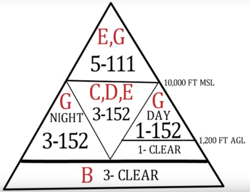
Draw the Weather Minimum triangle:
List all the special use airspace:
WARMPCN
W Warning (Extends 3 NM out to shore)
A Alert
R Restricted*
M MOA
P Prohibited*
C CFA (Not depicted, NOTAM)
N NSA
*Regulatory, illegal unless permission is given.
What is required to cross an ADIZ?
Working transponder with altitude encoding, two way radio, file an IFR or Defense VFR, depart within 5 minutes of flight plans departure time.
What are the max aircraft speeds in the US?
Mach 1.0 above 10,000’ MSL
250 kts below 10,000’ MSL
200 kts under Class B or within a VFR corridor through Class B
200 kts at or below 2,500’ within 4 NM of the primary airport of a Class C or D airspace
*If the minimum safe airspeed is wont allow these restrictions than operate at minimum speed
What are the types of weather briefings?
Standard: A full briefing on all weather for the flight plan
Abbreviated: Updates previously received information as a summary
Outlook: For departures 6 or more hours away
Inflight: FSS inflight briefing
What is an AIRMET?
An advisory of significant weather which can be hazardous for smaller aircraft.
What are the types of AIRMET?
Airmet Tango:
Moderate Turbulence
Sustained surface winds 30 kts or greater
Non convective LLWS
Airmet Zulu:
Moderate icing
FZ levels
Airmet Sierra:
Mountain Obscurations
IFR Conditions
How often are AIRMETs issued and valid for?
Issued: As needed
Valid for: 6 hours
What is a SIGMET? What are they issued for?
An advisory of significant non-convective weather.
Severe icing
Severe to Extreme Turbulence or CAT
Dust storms, sandstorms lowering surface visibility below 3 SM
How often are SIGMETs issued and valid for?
Issued: As needed
Valid for: 4 hours (6 hours for hurricanes)
What is a Convective SIGMET? What are they issued for?
An advisory of convective weather significant to all aircraft.
Severe TS due to:
Surface winds greater or equal to 50 kts
Hail at the surface greater than ¾ inch in diameter
Tornadoes
Embedded TS
A line of TS at least 60 mi longs with TS affecting 40% of its length
TS producing heavy or greater precip affecting 40% of a 3000 sq mi area
*Any convective SIGMET implies severe or greater turbulence, severe icing, and LLWS
How often are Convective SIGMETs issued and valid for?
Issued: Every hour 55 past the hour
Valid for: 2 hours
What is an Interntional SIGMET? What are they issued for?
Issued outside of the CONUS and follow ICAO coding standards.
TS occurring in lines, embedded in clouds, or in large areas producing tornados or large hail
Tropical Cyclones
Severe Icing
Severe to Extreme Turbulence
Dust Storms and sandstorms lowering surface visibility to less than 3 SM
Volcanic Ash
What is a SPECI?
When conditions change since the last METAR a SPECI is issued.
What is the radius of a TAF and how often are they issued a day?
5 SM radius from the center of the runway environment. Issued 4x a day.
What is the forecast period in hours for a TAF?
Usually 24 hours, 30 hours for larger airports
What is a Surface Analysis Chart and what does it depict? How often are they issued?
A report on pressure systems, isobars, fronts, station information (like winds, temps, and precip)
Issued every 3 hours
What is a Unified Surface Analysis Chart?
A Surface Analysis Chart from the 4 centers produced every 6 hours.
Stations: OPC, WPC, NHC, and HFO
What is a Radar Summary Chart? How often is it issued?
An hourly summary of radar info like:
Precipitation type
Type, coverage, movement, echoes, and maximum tops
How often are Winds Aloft forecast issued?
Every 6 hours, or 4x daily
Why are winds and sometimes temperature omitted in Winds Aloft reports?
Winds: Station is within 1,500’ of the airport field elevation
Temp: Station is within 2,500’ of the airport field elevation
What unit are winds aloft reported in?
Winds: True Knots
Temp: Celsius
What altitude do Winds Aloft reports top reporting temperature as negative?
FL240
What is a Low Level Significant Weather Prognostic Chart? From what altitudes does it range and how often is it published?
Forecasts significant weather conditions for a 12 and 24 hour period.
Surface to 24,000’
Issued 4x daily
What is a Mid-level significant weather chart? From what altitudes does it range and how often is it published?
Forecasts of significant weather at various altitudes and flight levels.
10,000’ MSL to FL450
Issued 4x daily
What is a High-level Significant Weather chart? From what altitudes does it range and how often is it published?
Depicts forecasts of significant weather phenomena.
FL250 to FL630
Issued 4x daily
What is a Convective Outlook?
A 3-day forecast of convective activity
How often for each of the 3 days is the forecast published for a Convective Outlook?
Day 1: 5x a day
Day 2: 2x a day
Day 3: 1x a day
What does a Visible Weather Satellite image show?
Cloud coverage based on visible light reflection, not useful for identifying cloud height. (At night nothing is seen)
What does a Infrared Weather Satellite image show?
Measure cloud top temperature and shows clouds coverage
Highest clouds appear bright white
Middle clouds shades of gray
Low clouds and fog are dark gray
On an Infrared Weather Satellite Image, what color is each type of cloud depicted as? Why?
High Clouds: Bright White
Middle Clouds: Shades of gray
Low Clouds & Fog: Dark Gray
As the clouds decrease in altitude the light received by the sun is less making it appear darker.
What does a Water Vapor Weather Satellite image show? What color are the moist and dry areas?
Shows areas of moist and dry air in shades of gray from white to black
Moist areas are bright white
Dry air is black
What is NEXRAD?
Next Generation Weather Radar, which provides very accurate weather info like precipitation and storm tracking
What is a Ceiling & Visibility chart?
Shows ceiling based on surface observations, now replaced with HEMS tool at AWC
What conditions are required for the formation of a thunderstorm?
1. Moisture
2. Unstable atmosphere
3. Lifting action
What are the three stages of a thunderstorm?
1. Cumulus: Lifting action of air begins
2. Mature: When rain begins to fall, all hazards at its strongest
3. Dissipating: Downdrafts
What are the types of thunderstorms?
Supercell: Single, long lived cell that has a rotating updraft (mesocyclone)
Single Cell: Singular TS cell, formed in warm, humid days.
Multi Cell: Multiple TS cells, that cover a wide area
Squall: A long line of TS, usually ahead of a Cold Front
Embedded: A TS embedded in a layer of clouds
What type of weather does a Low Pressure System bring? In which way does wind flow around this system?
Bad weather, but good visibility. Wind flows counterclockwise and upward.
What type of weather does a High Pressure System bring? In which way does wind flow around this system?
Good weather, and good visibility. Wind flows clockwise, and downward.
What is a Warm Front? How fast is it?
A warm body of air replacing and covering a cold body of air/ Usually 10-25 mph
What weather can we expect in a Warm Front as it arrived, while in the front, and after it leaves?
Arriving: Stratiform and Cirriform clouds and fog
During: Light to Moderate precipitation, and low visibility
After: Improving visibility with some wind, but hazy
What is a Cold Front? How fast is it?
A cold body of air replacing and sliding underneath a warm body of air. Usually 25-30 mph.
What weather can we expect in a Warm Front as it arrived, while in the front, and after it leaves?
Arriving: Towering Cumulus/Cirriform, sometimes Cumulonimbus, and Squall Lines are common
Types of clouds depend on warm airs stability beforehand
During: Bad weather depending on clouds, and strong winds
After: Clouds will clear, precipitation decreases, but gusty winds, and cold temps
What is a Stationary Front?
Two air masses of equal force collide causing the front not to move.
What type of weather is associated with a Stationary Front?
Both Warm and Cold Front weather, depending on which air mass is stronger
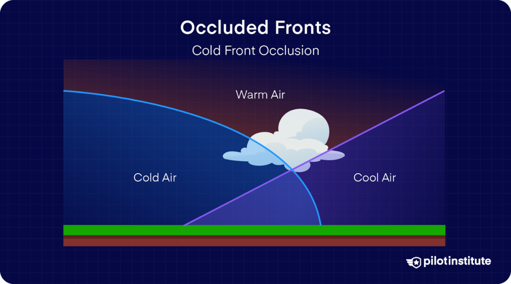
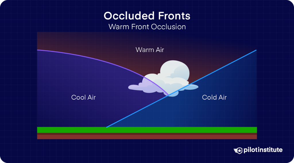
What is an Occluded Front and it’s two variants? What weather is associated with an Occluded Front?
When a faster moving cold front catches up to a slower moving warm front. Weather is warm front then immediately cold front weather.
Cold Front Occlusion:
Warm Front Occlusion
What is a Cold Front Occlusion? What type of weather?
When the Cold Front’s air is colder than the air mass in front of the warm front. Both frontal weather.
What is a Warm Occlusion? What type of weather?
When the air ahead of the warm front is colder than the air behind the warm front. This results in the cooler air sliding up and lifting the warm air further.
Severe weather, embedded TS, rain, and fog
What is the name attributed to a formation of a front?
Frontogenesis
What is the name attributed to a dissipation of a front?
Frontolysis
What is fog, when does it occur?
A cloud that begins within 50’ of the surface.
Air temperature near the ground reaches it dew point or;
Dew point is raised to the existing temperature by added moisture to the air
What are the types of fogs? How are they formed?
ISUPRA
I Ice: Water vapor turns directly into ice crystals
S Steam: Cold, dry air moves over warm water, moisture is added to the airmass and fog forms
U Upslope: Moist, stable air is forced up a terrain slope a cooled down
P Precipitation: Warm rain falls through a cold air mass and condenses
R Radiation: Calm, clear nights when ground cools rapidly due to the release of ground radiation
A Advection: Warm, moist air moves over a cool surface (required some wind)
What are the types of Structural Icing?
Instrument Ice, Induction Ice, Intake Ice, Carburetor Ice, and Frost
What is Instrument Icing?
Ice over the instruments, pitot and static
What is Induction Icing?
Ice reducing the amount of air for the engine intake
What is Carburetor Icing?
Ice in the venturi, temps from -7 to 21 C and high relative humidity (80%)
What is Intake Icing?
Blocks the engine intake
What is Frost?
Ice crystals caused by deposition when temp and dew point are below freezing
Deposition: Gas turns to Ice
What conditions are required for structural ice?
Visible Moisture and Aircraft surface temperature below freezing.
What is Mixed Ice? What temperatures is Mixed Ice prominent?
Formation of a combination of Clear and Rime Ice
What clouds does Mixed Icing form in?
A combination of Cumulus and Stratus clouds.
What is Rime Ice? What temperatures is Rime Ice prominent?
Droplets freeze on impact resulting in air pockets under the ice, which gives it a milky white color. From -10°C to -20°C
What clouds is Rime Ice found in?
Stratus Clouds
What is Clear Ice? What temperatures is Clear Ice prominent?
Moisture hits the leading edge and trails to the trailing edge while freezing. From -10°C to 0°C
What clouds is Clear Ice found in?
Cumulus Clouds
Which type of icing is most dangerous Rime, Clear, or Mixed? Why?
Clear Ice, because it’s heavy, hard to remove, and because it is hard to see.
Is the Piper Archer certified to fly through known icing conditions?
No, it is illegal since the Archer does not have any deicing or anti-icing equipment.
What is the difference between Deicing and Anti-Icing equipment?
Deicing: Removes ice that has already formed (Like an icing boot)
Anti-icing: Prevents ice from forming (Like a weeping wing)
If we encounter icing, what should we do?
Descend (If terrain permits), and turn around if flying through clouds.
What is hypoxia? What are the types?
Hypoxia is the lack of oxygen being delivered to the brain
Hypoxic: Not enough oxygen being received to the body by atmosphere
Histotoxic: Drugs or alcohol limiting oxygen received by blood
Hypemic: Blood can’t carry O2 due to CO poisoning, blood loss, or anemia
Stagnant: Blood not moving due to excessive G’s being pulled, heart problems, or constricted blood vessels
What are some symptoms of hypoxia?
Headache, confusion, euphoria, and cyanosis (blue fingertips)
What is hyperventilation? What symptoms can you expect? How can you remedy it?
A condition which occurs when excessive CO2 is removed from the body which constricts the blood vessels in the brain.
Breath into a paper bag, or speak aloud
What are some symptoms of hyperventilation?
Dizziness, shortness of breath, confusion, numbness, passing out
What is Decompression Sickness?
Gasses from scuba diving (mainly nitrogen) are released by the body, as you climb in altitude these gasses expand on the joints, nerves, and muscles which pain the body.
Uncontrolled ascent: Wait 12 hours for flights up to 8,000’, 24 hours for flights above
Controlled ascent: 24 hours for any altitude
What are the Supplemental Oxygen Requirements?
12,500 to 14,000 MSL: Req. minimum flight crew must be provided with and use O2 for flights 30 minutes at these altitudes
Greater than 14,000’ MSL: Req. minimum flight crew must use O2 at these altitudes
Greater than 15,000’ MSL: Each occupant must be provided with O2
What is the Vestibular System?
An system consisting of organs that can sense pitch, roll, and yaw.
3 semicircular canals filled with fluid move against tiny sensory hair as the head is moved
2 otolith organs, the utricle and saccule sense acceleration.
What is the Somatosensory System?
Nerves in the skin, muscles, and joints.
What is the Visual System?
Visual cues from our eyes.
List all of the Vestibular Illusions?
Leans, Coriolis, Graveyard Spiral, Somatogravic, Inversions, and Elevator
What is the Leans Illusion?
After leveling the wings after a prolonged turn a pilot may feel the aircraft banked in the opposite direction
What is the Coriolis Illusion?
After a prolonged turn the fluid in the ear stabilizes, a sudden head movement can give a false indication
What is the Graveyard Spiral Illusion?
A pilot in a prolonged, coordinated constant-rate turn may experience the illusion of not turning, after leveling the wings the pilot may suffer from the leans turning back to the original turn, to remain level back pressure is applied to maintain altitude making the turn tighter increasing the loss of altitude
What is the Somatogravic Illusion?
Rapid acceleration caused a nose high feeling, the pilot lowers the nose in response. Rapid deceleration does the opposite, a nose low feeling
What is the Inversion Illusion?
An abrupt change from climb to straight and level may create the illusion of tumbling backwards
What is the Elevator Illusion?
An abrupt upward acceleration may create the illusion of climbing
What are the Visual Illusions?
False Horizon, and Autokinesis
What is the False Horizon Illusion?
The pilot mistakes a layer of clouds, city lights, or and obscured horizon as the actual horizon.
What is the Autokinesis Illusion?
Staring at a stationary point may cause the light to be moving
How can you calculate distance off course from a VOR?
Distance off course = 200’ per dot deflection per NM from VOR
How can you calculate angle of bank to maintain a standard rate?
(KTAS / 10) x 1.5 = angle of bank
What aircraft category is the Piper Archer and what is our circling maneuver radius? How do we calculate our approach category?
Category A, 1.3 NM. 1.3 Vso