SCIENCE BABYYYY (im cooked)
1/47
There's no tags or description
Looks like no tags are added yet.
Name | Mastery | Learn | Test | Matching | Spaced | Call with Kai |
|---|
No analytics yet
Send a link to your students to track their progress
48 Terms
Main layers of the earth
The main layers of the Earth are the crust, mantle, outer core, and inner core, each varying in composition and physical state.
Crust
The crust features include continental and oceanic crust, with varying thickness and composition. It is the Earth's outermost layer, where we find landforms, soil, and water.
Mantle
The mantle is the layer between the crust and the outer core, composed mainly of silicate rocks that can flow slowly over time. It is much thicker than the crust and is involved in tectonic plate movements and geothermal processes.
Outer core
The outer core is the layer beneath the mantle and above the inner core, composed primarily of liquid iron and nickel. It is responsible for Earth's magnetic field through its flow and movement.
Inner core
The inner core is the Earth's innermost layer, composed mainly of solid iron and nickel, with extremely high temperatures and pressure. It is situated at the center of the planet, below the outer core. It contributes to Earth's magnetic field and is under immense heat and pressure.
Layers of the atmosphere
The layers of the atmosphere include the troposphere, stratosphere, mesosphere, thermosphere, and exosphere. Each layer has distinct characteristics and plays a vital role in weather patterns and climate.
Troposphere
The troposphere is the lowest layer of Earth's atmosphere, where weather occurs and temperature decreases with altitude. It contains most of the atmospheric mass and is closest to the Earth's surface.
Stratosphere
The stratosphere is the second layer of Earth's atmosphere, located above the troposphere. It contains the ozone layer, which absorbs and scatters ultraviolet solar radiation, and is characterized by a temperature increase with altitude.
Mesosphere
The mesosphere is the third layer of Earth's atmosphere, situated above the stratosphere. It is where temperatures decrease with altitude, and is known for being the coldest atmospheric layer.
Thermosphere
The thermosphere is the fourth layer of Earth's atmosphere, located above the mesosphere. It is characterized by a significant increase in temperature with altitude and contains the ionosphere, which is important for radio communication.
Exosphere
The exosphere is the outermost layer of Earth's atmosphere, situated above the thermosphere. It gradually fades into outer space and is characterized by extremely low densities of hydrogen and helium gases. It is where atmospheric particles are so sparse that they can travel hundreds of kilometers without colliding with one another.
How do Auroras form?
Auroras form when charged particles from the solar wind collide with atoms in Earth's atmosphere, creating stunning displays of light typically seen near the polar regions.
Plate tectonics
A scientific theory explaining the movement and interactions of the Earth's lithosphere, which is divided into tectonic plates. These movements are responsible for geological phenomena such as earthquakes, volcanic activity, and the formation of mountain ranges.
Continental drift
The theory that the continents have moved over geological time and were once joined together in a single landmass, known as Pangaea. It explains the distribution of fossils and geological formations across continents.
Evidence for continental drift
includes similarities in fossil records, matching geological formations, and the fit of continental coastlines, supporting the idea that continents were once connected.
Convection currents
are the circular movements of fluid caused by the heating and cooling of material within the Earth's mantle. These currents are key drivers of plate tectonics, facilitating the movement of tectonic plates.
Convection currents’ importance within the earth
lie in their role as a driving force for plate tectonics, influencing the movement of tectonic plates and contributing to geological activity like earthquakes and volcanic eruptions.
Seafloor spreading
is the process by which new oceanic crust is created at mid-ocean ridges as tectonic plates pull apart, causing the seafloor to expand.
Seafloor spreading (as evidence for the theory of plate tectonics)
is the process indicating that as tectonic plates move apart, new oceanic crust forms, providing proof of the continuous renewal of the ocean floor and the movement of plates.
Magnetic striping
is the pattern of magnetic reversals in oceanic crust that occurs as seafloor spreading takes place, creating symmetrical patterns on either side of mid-ocean ridges, which supports the theory of plate tectonics.
Magnetic striping (to tell the age of rocks)
is used to determine the age of oceanic rocks by analyzing the magnetic orientation recorded during their formation, indicating periods of magnetic reversals and helping to date the crust.
Major tectonic plates of the earth
The major tectonic plates are the African plate, the Antarctic plate, the North American plate, the South American plate, the Eurasian plate, the Indo-Australian plate, and the Pacific plate.
How can Australia still have earthquakes if it is not on a plate boundary?
Australia experiences earthquakes due to intraplate stresses within the Indo-Australian plate, which can generate faults and small seismic events despite being located away from major plate boundaries.
Types of plate boundaries
are classified as divergent, convergent, and transform boundaries, each characterized by different interactions between tectonic plates, leading to various geological features and seismic activity.
Divergent plate boundary
A type of plate boundary where two tectonic plates move away from each other, typically resulting in the formation of new oceanic crust and mid-ocean ridges.
Convergent plate boundary
A type of plate boundary where two tectonic plates move toward each other, often resulting in subduction zones, mountain ranges, and volcanic activity.
Transform plate boundary
A type of plate boundary where two tectonic plates slide past each other horizontally, typically leading to earthquakes.
Anatomy of a volcano
Magma Chamber: A large reservoir beneath the volcano that contains molten rock (magma).
Main Vent: The primary opening through which magma erupts onto the surface.
Secondary Vent: Smaller openings on the sides of the volcano where eruptions can also occur.
Crater: A bowl-shaped depression at the top of the volcano, formed by explosive eruptions.
Caldera: A large, basin-like depression formed by the collapse of a volcano after a major eruption.
Lava Flows: Streams of molten rock that flow down the volcano's slopes during an eruption.
Pyroclastic Flows: Fast-moving currents of hot gas and volcanic debris (ash, rock fragments) that can be extremely dangerous.
Types of volcanoes
Cinder Cones, Composite Volcanoes (Stratovolcanoes), and Shield Volcanoes.
Cinder Cones
Small, cone-shaped volcanoes with steep slopes, formed from explosive eruptions. They primarily erupt cinders, ash, and rock fragments, creating a bowl-shaped crater.
Shield volcano
characterized by their broad, gently sloping profiles, resembling a warrior's shield laid on the ground. They are formed by the accumulation of fluid basaltic lava flows, which spread out over large areas. Eruptions from shield volcanoes are typically non-explosive, with lava
Composite volcanoes (stratovolcanoes)
Composite volcanoes, or stratovolcanoes, are large, cone-shaped volcanoes made of alternating lava and ash layers. Known for steep slopes and explosive eruptions, they pose hazards like pyroclastic flows and lahars.
P waves
P-waves, known as primary waves, are the fastest seismic waves that can travel through solids, liquids, and gases. They are longitudinal, causing compression and expansion in the direction of wave travel.
S waves
a type of seismic wave. They are transverse waves, meaning they move perpendicular to the direction of wave propagation. Unlike P waves (primary waves), which can travel through solids, liquids, and gases, S waves can only travel through solids. This is because they rely on shear stress, which liquids and gases cannot support.
Tsunami
a series of powerful ocean waves caused by sudden disturbances, such as earthquakes, underwater landslides, volcanic eruptions, or even asteroid impacts. Unlike regular waves, which are driven by wind, tsunamis involve the movement of water from the seafloor to the surface, allowing them to travel at speeds of up to 800 km/h (500 mph) in deep water.
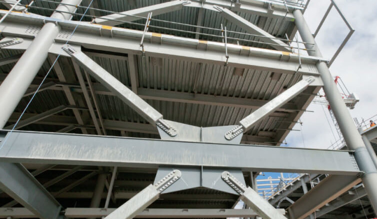
Moment frame
a structural system designed to resist lateral forces, such as those caused by earthquakes or strong winds. It consists of beams and columns rigidly connected, allowing the frame to absorb bending moments and shear forces without relying on additional bracing.
Braced frame
a structural system designed to resist lateral forces, such as wind and earthquakes, by using diagonal bracing to reinforce the frame. These braces prevent excessive sway and improve the stability of buildings.
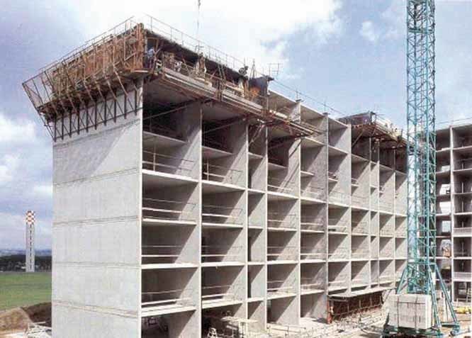
Shear wall
a key structural element that resists lateral forces, such as earthquakes and strong winds, preventing excessive sway. Made of reinforced concrete, steel, or masonry, it ensures stability by distributing forces evenly. Common in high-rise buildings, shear walls enhance safety by reducing structural damage and preventing twisting during seismic events.
How does base isolation help during earthquakes
a technique that protects buildings from earthquake damage by separating them from ground motion. Using specialized isolators like elastomeric bearings, it absorbs seismic energy and allows controlled movement, reducing vibrations. This minimizes acceleration forces, prevents structural damage, and helps maintain building functionality after an earthquake, making it ideal for medium-rise concrete structures.
Epicentre
is the point on the Earth's surface directly above the hypocentre (or focus), where the earthquake originates underground. While the epicentre is often associated with the strongest shaking, the most severe damage can occur elsewhere, depending on the earthquake's depth and the local geology
How can earthquakes be predicted
Scientists use techniques like monitoring seismic activity, analyzing historical earthquake patterns, studying ground deformation, and applying machine learning models to detect warning signs. While these methods help assess earthquake risk, precise prediction remains impossible. Instead, early warning systems detect initial seismic waves and alert people seconds to minutes before shaking begins.
How can tsunamis be predicted
Predicting them involves monitoring seismic activity, ocean pressure changes, and tide levels. Scientists use Deep-Ocean Assessment and Reporting of Tsunamis (DART) systems, which detect shifts in water pressure and provide real-time warnings. AI-based models are also being developed to analyze underwater sound signals and improve prediction accuracy.
How can volcanic eruptions be predicted
These include seismic activity tracking, ground deformation studies, and gas emission analysis. Volcanoes often show warning signs, such as increased tremors, swelling of the ground, and changes in gas composition, which indicate rising magma. While forecasting methods have improved, precise eruption predictions remain difficult due to the complex nature of volcanic systems.
How do geothermal power plants work
generate electricity by harnessing heat from the Earth's interior. They work by extracting hot water or steam from underground reservoirs and using it to spin turbines, which drive generators to produce electricity. The cooled water is then re-injected into the ground to sustain the cycle.
GPS
(Global Positioning System) is a satellite-based navigation system that provides location and time information anywhere on Earth. It works by using a network of satellites that continuously transmit signals.
how GPS can be used to measure the movement of tectonic plates
measuring tectonic plate movement with millimeter-level precision. Scientists place GPS receivers on stable bedrock, allowing them to track how plates shift over time. By analyzing data from multiple stations, researchers can determine the speed and direction of plate motion.
Advantages of geothermal energy
a reliable, renewable power source that generates electricity with minimal emissions. It offers consistent energy production, a small land footprint, and supports sustainability by reducing reliance on fossil fuels.
Disadvantages of geothermal energy
including high initial costs, limited suitable locations, and potential depletion of underground heat sources. Some plants release trace gases, and fluid injection can occasionally trigger small earthquakes. Deep drilling also requires advanced technology, adding to operational challenges.