GL102 FINAL
1/222
There's no tags or description
Looks like no tags are added yet.
Name | Mastery | Learn | Test | Matching | Spaced | Call with Kai |
|---|
No analytics yet
Send a link to your students to track their progress
223 Terms
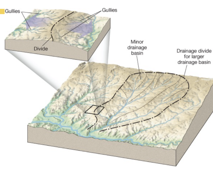
What is a drainage basin?
A land area where all water drains into a specific stream or river.
What is a divide?
a geographical barrier, often a mountain range or ridge, that separates drainage basins and directs the flow of water to different river systems.
What are two sources of water in a drainage basin?
runoff (surface water) and base flow (groundwater)
Drainage Pattern
shape or layout of stream networks in drainage basin
What's the most common drainage pattern?
Dendritic Tree
irregular branching of tributaries, similar to those of a tree
What is the largest watershed in the world?
The Great Lakes–St. Lawrence River Basin.
How much of the world’s surface freshwater does the Great Lakes–St. Lawrence River Basin hold?
over 20%
How much of North America’s surface freshwater does it hold?
about 84%
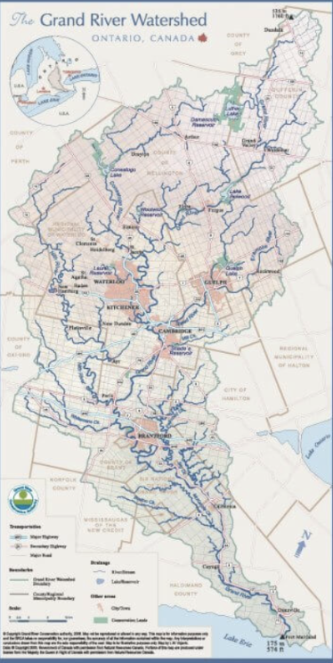
Grand River Watershed
a major watershed in Ontario, Canada
has a dendritic pattern, which connects many tributaries and flows out into lake eerie

What tributaries does the Grand River watershed connect to?
larger ones
conestogo, speed, eramosa, nith rivers
smaller ones
laurel creek and schneider creek
Flood
when the discharge of a stream exceeds the capacity of its channel (river, lake), it overflows its banks.
Reoccurance interval
an estimate of how often a flood of a given size can be expected to occur
100-year flood event is likely to happen after a long period, but has a higher magnitude
a 25-year flood event is likely to reoccur every 25 years, but has a lower magnitude
the larger the flood, the less often its expected to occur
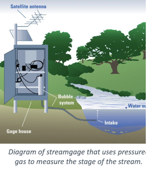
Stream-Gauging Stations
are monitoring sites that measure the flow rate and water level of rivers and streams.
Regional Floods
prolonged or seasonal weather conditions that cause a large volume of water to accumulate overtime
Factors that cause regional flooding
snowmelt, prolonged rainfall, frozen or saturated ground (no infiltration = ground can’t absorb more water which leads to runoff), more commonly caused by slow moving storm systems, such as decaying hurricanes
Flash Floods
are sudden and intense floods caused by heavy rainfall or rapid snowmelt, often occurring with little warning and can lead to immediate and severe flooding.
mountains are susceptible due to their steep slopes and rapid runoff.
Factors that affect flash floods
rainfall intensity
rainfall duration
surface conditions
topography
steep slopes = fast runoff
narrow valleys = funnel effect (increases speed and force)
low lying areas = water pooling
Why are urban areas susceptible to flash floods?
high percentage of their surface area is composed of impermeable surfaces like roofs and pavement, which prevent infiltration because there’s no soil to absorb the water. this causes runoff to accumulate rapidly, leading to increased flood risk.
Ice-Jam floods
Ice tends to block stream flow, which causes water to back up and flood: when the ice breaks or melts, flash flood occurs
Dam-Failure floods
if larger flood occurs, of more magnitude (more than levee or dam is designed to handle), dam/levee can fail, releasing water, causing a flash flood
What are artificial levees?
mounds built on the banks of a river to contain floodwaters and prevent overflow from inundating surrounding areas.
What are the downsides to artificial levees?
levee has to be raised periodically to protect floodplain, as each time there’s high waters, rivers deposit sedimentsand reduce the capacity of the levee.
What are flood-control dams?
built to store floodwater, and let it out slowly.
lowers the flood crest (highest level of water during flood) by spreading it out over a longer time
what are some non-flood-related functions dams have?
irrigation (artificial supply of water to agriculture)
hydroelectric power generation
recreational facilities
Fanshawe and Wildwood in southern Ontario
Consequences of dams
can include ecosystem disruption, displacement of communities, sedimentation issues, and changes in water quality. sedimentation behind a dam also means that less sediment reaches downstream ecosystems, which can harm habitats and affect species that depend on sediment.
Channelization
altering a stream channel to control water flow, often to prevent flooding and reach flood height
How is channelization done?
learning a channel of obstructions or dredging a channel to make it wider and deeper
How much of groundwater is drinking water?
more tha 50 percent of the world's drinking water supply comes from groundwater sources.
Where is the rest of groundwater used?
40 percent for irrigation, more than 25% for industrial needs
what are some results due to the overuse of groundwater?
water shortage
stream flow depletion
land subsidence (sinking of ground)
increased pumping cost
groundwater pollution
What is groundwater?
Water stored in the pores and fractures of soil and rock below Earth’s surface.
What represents the largest reservoir of freshwater for humans?
Groundwater
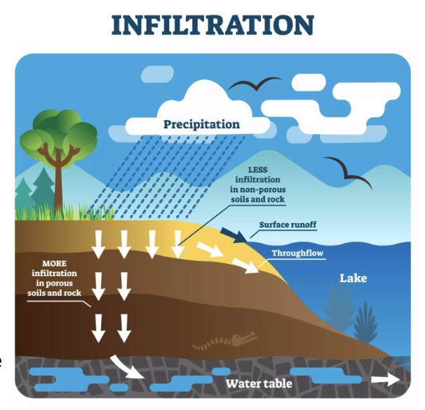
How does topography and amount of precipitation affect infiltration?
heavy rain on steep slopes = more runoff
gentle rain on gradual slopes or flatter grounds = more infiltration

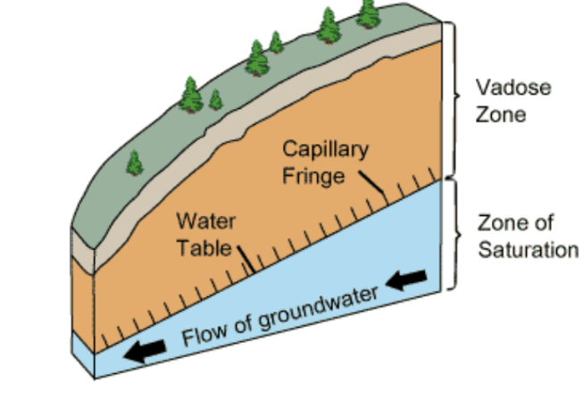
Zone of saturation
The underground layer where all the pores and fractures in soil and rock are filled with water, below the water table.
this water is ground water, that can be pumped out and used.
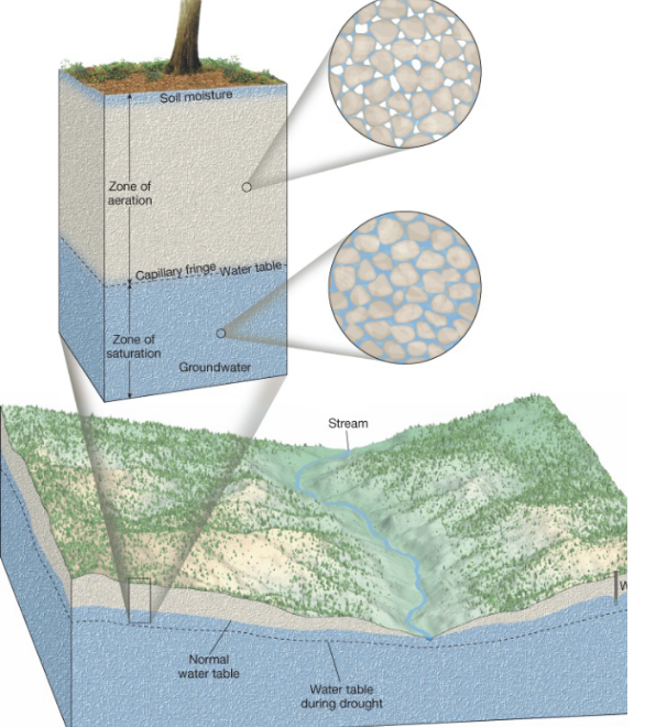
Zone of aeration
area above the water table that includes capillary fringe (zone above water table where groundwater slightly rises)
Why can’t water be pumped from zone of aeration?
although there’s sufficient water to be pumped out from this zone, it cannot be pumped out due to the fact that it clings tightly to rock and soil particles, making it unavailable for extraction.
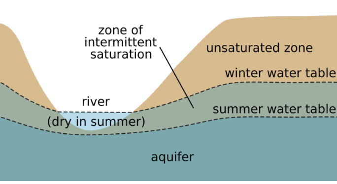
What is the water table and why is it important?
upper limit of the zone of saturation
important for
indicating groundwater level (how deep you have to go to reach water underground)
saturation point (marks line below which ground is fully saturated with water)
environmental indicator (rising water table may indicate heavy rainfall or flooding risk)
How deep can a water table be?
It can range from 0 (at the surface) to hundreds of meters deep, depending on the location.
What causes seasonal variations in water table?
variations in precipitation - its amount, timing and distribution - affect the addition of water to the groundwater system, causing water table to fluctuate
How can seasonal water table fluctuations affect rivers?
Rivers may dry up during dry seasons when the water table drops below the stream bed
Why do lakes and streams often lie above the water table?
They occupy low-lying areas where the water table intersects or rises above the land surface.
Why is the water table surface uneven?
Because groundwater moves slowly and accumulates beneath high areas between stream valleys, causing a "piling up" effect.
What does the nature of subsurface materials affect?
rate of groundwater movement
amount of groundwater that can be stored
What two main factors influence groundwater storage and movement?
porosity
permeability
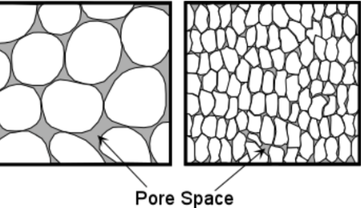
Porosity
percentage of total volume in rock or sediment that consists of pore spaces
What determines a material’s porosity?
Grain size/shape, packing, sorting, and amount of cementing material in sedimentary rocks
clay may have porosity as high as 50 percent but gravel has much lower porosity, 20%, due to larger grain sizes and less pore space.
Why might mixed grain sediments have lower porosity?
Finer particles fill the voids between larger grains, reducing pore space.
Do igneous and metamorphic rocks have high porosity?
No, they usually have tightly interlocking crystals with next to no pore space.
any groundwater movement or storage can only occur if there’s fractures or cracks
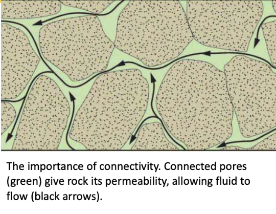
what is permeability
A material's ability to transmit fluids — it depends on connected pore spaces that are large enough to allow flow.
Can a rock be porous but not permeable?
Yes — if the pores aren’t connected or are too small for water to pass through.
What are aquifers?
Permeable rock or sediment layers that transmit groundwater freely, like sands and gravels.
What materials make poor aquifers and why?
Clays, because they hinder or prevent water movement due to their low permeability.
How does groundwater typically move?
moves slowly from pore to pore—only a few centimetres per day—pulled by gravity.
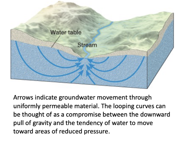
In which direction does groundwater move?
It moves from high areas of the water table to lower areas where water table is low, often toward streams, lakes, or springs.
What affects the direction of groundwater flow?
A combination of gravity pulling downward and water moving toward zones of reduced pressure.
What determines the velocity of groundwater flow?
The slope of the water table; steeper slopes = faster flow due to greater pressure differences.
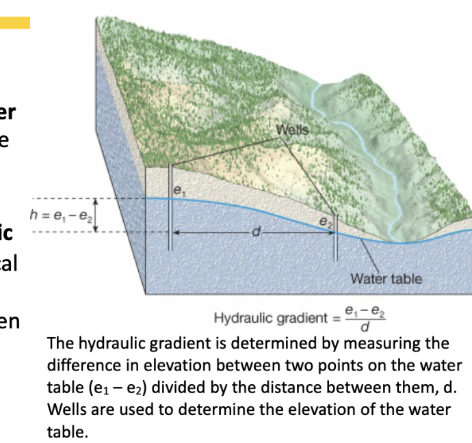
What is the hydraulic gradient?
It’s the slope of the water table, calculated by dividing the vertical height difference by the horizontal distance between two points.
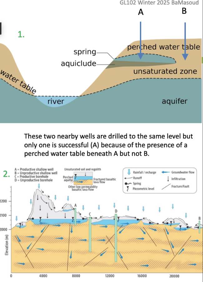
What is a spring?
natural outflow of groundwater that occurs where the water table intersects the earth
How do springs form?
springs form when an aquitard blocks the downward movement of groundwater and forces it to move laterally
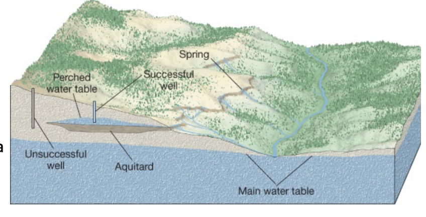
What are aquitards?
impermeable layers that hinder or prevent water movement

What is a perched water table?
A localized zone of saturation above the main water table, formed by an underlying aquitard that restricts downward flow.
Why might one well in a valley be successful and another not?
A well tapping into a perched water table may succeed, while one above it (not deep enough) may not reach water.

What is a hot spring?
A spring where water is 6°C to 9°C warmer than the local average air temperature due to geothermal heating.
How is groundwater heated to form hot springs?
By circulating deep underground, where temperature increases with depth (about 2°C per 100m).
Where are most North American hot springs and geysers found?
In the western regions, where igneous rocks and geothermal gradients are common.
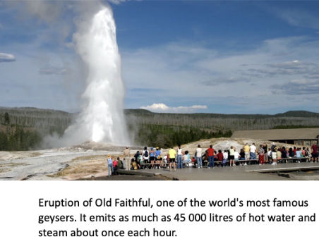
What is a geyser?
An intermittent hot spring that erupts forcefully with water and steam at regular intervals.
rising 30 to 60 minutes, caused by pressure buildup.
old faithful in Yellowstone national park, erupts once each hour

What causes geysers to erupt?
Heated water under pressure in underground chambers suddenly flashes to steam when pressure drops, forcing an eruption.
What happens after a geyser erupts?
The chamber refills with cool groundwater, and the cycle repeats.
Where do geysers typically occur?
Where extensive underground chambers exist within hot igneous rocks.
What heats the groundwater in geysers?
The surrounding hot rock.

Why doesn’t the water at the bottom of a geyser chamber boil at 100°C?
Because of the pressure from overlying water, requiring higher temperatures (e.g., ~230°C at 300 m depth).
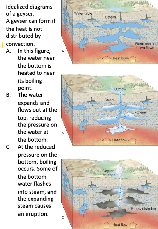
What causes a geyser eruption?
Pressure drops as some water escapes, lowering the boiling point, causing sudden steam formation and eruption.

What happens after a geyser erupts?
Cool groundwater seeps back into the chamber and the cycle begins again.
What is a well?
a hole bored into the zone of saturation (below water table) to extract groundwater
What is the most common use of groundwater in North America?
Irrigation for agriculture.
Why might two nearby wells produce different results?
Heterogeneous subsurface materials or presence of a perched water table.
example 1: well A may be successive due to presence of perched water table compared to well B
example 2: igneous and metamorphic rocks are not permeable except for their fractures and joints. if the well drilled into these rocks doesn’t intersect the fractures, well is successive
where must the well penetrate to ensure a continuous supply of water
below the water table, zone of saturation.
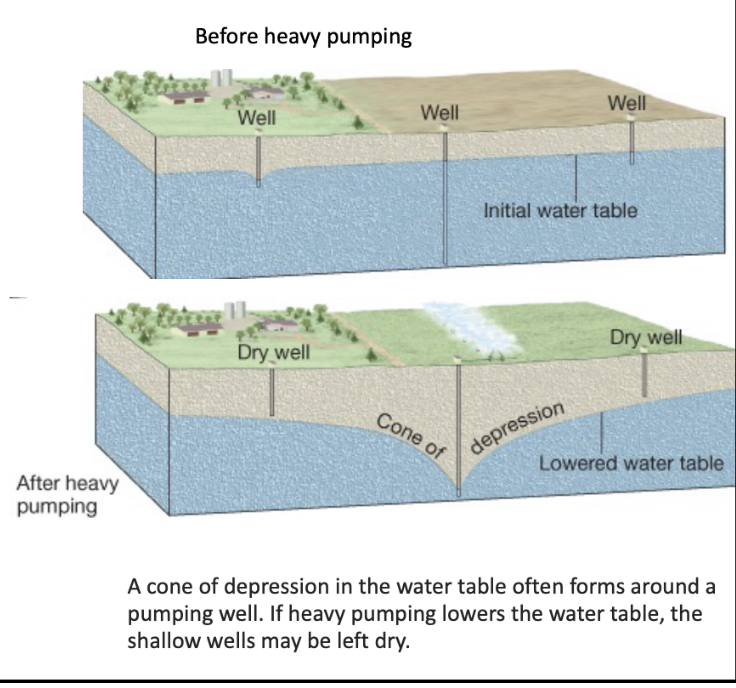
What is drawdown?
lowering of water table near a well due to water withdrawal
Cone of depression
a conical lowering of water table around a pumping well
if heavy pumping lowers water table, shallow wells may be left dry
What defines an artesian well?
A well where groundwater under pressure rises above the aquifer level.
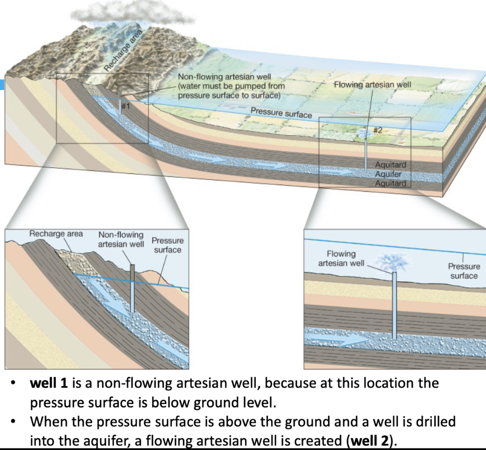
What conditions are required for an artesian system?
occurs when a confined aquifer is sandwiched between impermeable layers (aquitards), allowing water under pressure to rise naturally.
What is the difference between flowing and non-flowing artesian wells?
Flowing artesian wells have pressure surfaces above ground; non-flowing ones do not.
How has tapping artesian aquifers affected areas like South Dakota?
Overuse led to decreased pressure and stopped natural flow in many wells.
What causes the water table to lower?
An imbalance between recharge and discharge/withdrawal.
Why is groundwater sometimes considered non-renewable?
Because it can take thousands of years to replenish and is being withdrawn faster than it can be replenished.
What is land subsidence and how does it occur?
Sinking of land due to groundwater overpumping which compacts the sediment.
What are common sources of groundwater pollution?
Septic tanks, broken sewer systems, and farm waste.

How can groundwater be naturally purified?
Through sediment filtration, oxidation, or microbial activity.
Why is purification not always effective?
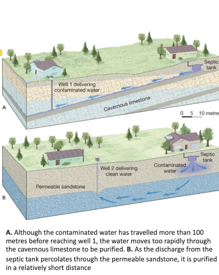
Water may move too quickly through highly permeable materials like cavernous limestone.
What’s a risk of drilling wells in contaminated areas?
It can draw pollutants into the aquifer if not properly managed.
What can happen if a well pumps large amounts of groundwater?
It creates a cone of depression, increasing the water table's slope, which can lead to contamination of previously clean wells.
rate of groundwater movement increases as slop of water table gets steeper
Why is a steeper water table slope a concern for groundwater purity?
It causes water to move faster, reducing the time available for natural purification in the aquifer.
How can septic tanks contribute to well contamination?
Heavy pumping can alter groundwater flow direction, pulling contaminated water from septic systems toward nearby wells.
What are some common sources of groundwater contamination?
Highway salt, fertilizers, pesticides, industrial chemicals, leaking tanks, landfills, and holding ponds.
What is leachate, and why is it dangerous?
It's rainwater that has percolated through waste, dissolving contaminants, which can reach the water table and pollute groundwater.
Why can groundwater contamination go unnoticed for a long time?
Because groundwater moves slowly, pollution may only be detected after it affects drinking water and people get sick.
What is usually done after groundwater becomes contaminated?
The source is removed, the water supply is abandoned, and time is allowed for pollutants to flush out naturally.
What is the best method to deal with groundwater contamination?
prevention, abandon the water well
How does groundwater erode rock?
Slightly acidic groundwater (carbonic acid) dissolves soluble rocks like limestone, creating caverns and caves.
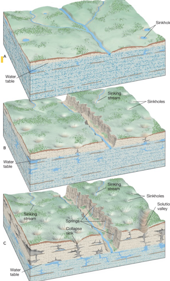
What is karst topography?
A landscape formed by the dissolution of soluble rock, featuring caves, sinkholes, and underground drainage.