APHG Unit 1 - MCQ
1/19
There's no tags or description
Looks like no tags are added yet.
Name | Mastery | Learn | Test | Matching | Spaced | Call with Kai |
|---|
No analytics yet
Send a link to your students to track their progress
20 Terms
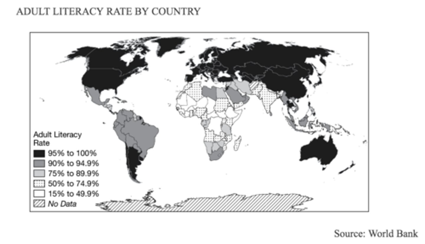
A nongovernmental organization is planning a new international elementary education program. Based on the map shown, which of the following groups of countries would be the best candidates to receive funding?
A. Brazil, Bolivia, Peru
B. Indonesia, Malaysia, Thailand
C. Mexico, Colombia, Ecuador
D. Egypt, Libya, Saudi Arabia
E. Ethiopia, Somalia, South Sudan
E

Which of the following best describes the spatial pattern of adult literacy rates presented in the map?
A. It provides an economic perspective on the productivity of each country's workforce.
B. It provides an economic perspective on earnings for each country's population.
C. It provides a political perspective on each country's level of civic participation.
D. It provides a political perspective on each country's system of government.
E. It provides a perspective on each country's level of social development.
E
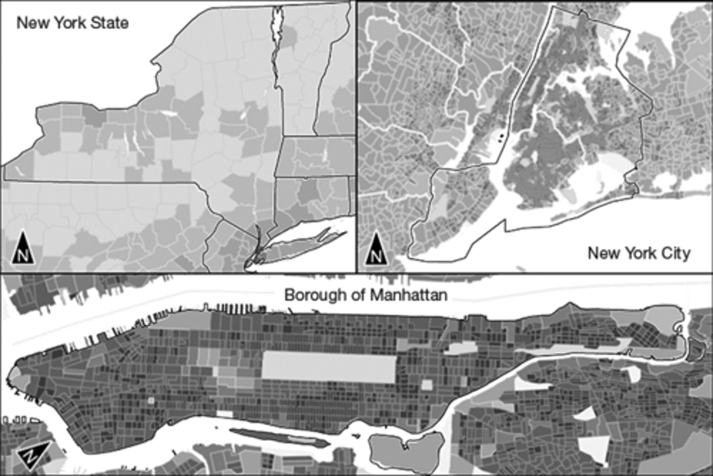
The darkest shading on the map indicates the areas with the highest population densities. Which of the following statements best describes the pattern of population density shown?
https://assets.learnosity.com/organisations/537/VR021322.g01.png
A. Manhattan appears to have the lowest population density at all three scales.
B. New York City's hinterlands have the highest population density.
C. Population densities appear to be uniform at all three scales.
D. New York City and New York State have similar population densities.
E. Manhattan appears to have the highest population density at all three scales.
E
Which spatial patterns on the maps shown would be most helpful to someone selecting the location for a new coffee shop?
A. The map of New York State, because it shows the least and most densely populated counties in the state.
B. The map of New York City, because it shows which boroughs have the greatest number of people.
C. The map of the Borough of Manhattan, because it shows both population density and the pattern of streets.
D. The map of the state of New York, because it shows where the largest cities are located.
E. The map of the Borough of Manhattan, because it shows the shoreline of the island of Manhattan.
C
Which of the following geospatial technologies is typically used to analyze the data layers such as those shown in the maps?
https://assets.learnosity.com/organisations/537/VR021393.g01.png
A. Aerial photography interpretation
B. Satellite navigation systems
C. Remote sensing satellites
D. Geographic information systems (GIS)
E. Global positioning systems (GPS)
D
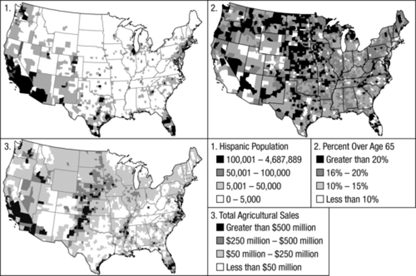
The maps show data most likely collected through
https://assets.learnosity.com/organisations/537/VR021393.g01.png
A. election results
B. census surveys
C. satellite imagery
D. informal observation
E. interviews
B

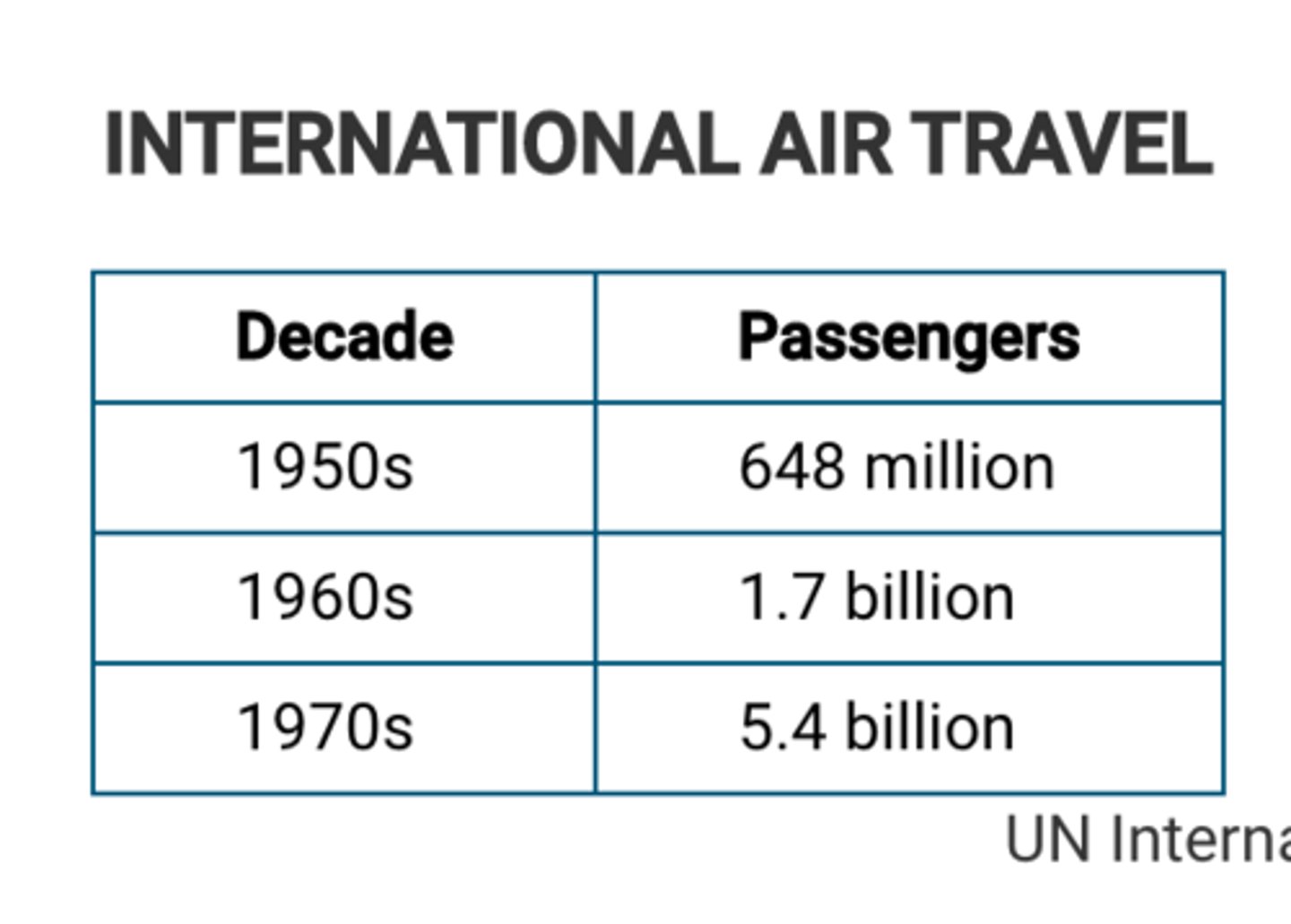
Which of the following types of information is shown in the table?
https://assets.learnosity.com/organisations/537/VH901705.g01.png
A. tax records
B. military enlistments
C. census data
D. diplomatic records
E. school enrollments
C
Which of the following statements best explains the concept of sustainability?
A. Natural resources are the domain of humans because of the ability of humans to take appropriate action for their use without fear of resource depletion.
B. Natural resources should be used until they become too scarce or too expensive because of the immediate need for human survival.
C. Natural resource use should be balanced with the needs of the environment and future generations because many resources are nonrenewable.
D. Natural resources will be replaced by technological goods because of concerns that all natural resources will become obsolete within the next generation.
E. Natural resource use should generate economic profits because of the new technologies that make procuring the resources cost effective.
C
In 1854, London physician Dr. John Snow mapped the spatial relationship between deaths from the waterborne disease cholera and the locations of water pumps which brought in water directly from tunnels connected to the River Thames. From Snow's research it was determined that a public water pump had been contaminated by sewage.
What geographic principle explains the significance of Snow's research?
A. As cities remove natural resources from the landscape, those resources become insignificant.
B. Even in areas of urban land use, there is a significant relationship between nature and society.
C. Once water enters an area of urban land use, that water is no longer considered a natural resource.
D. The prosperity of a society is determined by environmental factors, such as the availability of natural resources.
E. Societies leave a cultural imprint on the land, such as the pattern of streets and water systems.
B
Which of the following questions must be answered in order to identify a functional region?
A. What specific characteristic defines a region?
B. What general characteristics define the area's identity?
C. What do people call the region?
D. What languages are spoken in the area?
E. What area is influenced by a node?
E
For centuries, sugar crystals were made from the evaporated juice of sugarcane, a plant grown only in tropical and subtropical climates. In the 1800s, industrial methods were developed to manufacture crystalline sugar from sugar beets. This allowed for large amounts of sugar to be produced in colder, temperate climate zones.
Which of the following geographic concepts best explains the ability of humans to use technology to overcome the limitations of climate and modify the landscape?
A. Environmental determinism
B. Possibilism
C. Cultural relativism
D. Contagious diffusion
E. Political ecology
B
Which of the following concepts best explains the differences among the values shown in the table?
A. Spatial analysis
B. Scale of analysis
C. Map scale
D. Relative location
E. Relative direction
B

With the dawn of the Jet Age, international airline travel increased rapidly after 1950, and much of this early growth in jet travel was between Europe and North America. Which of the following best describes the spatial pattern suggested by the table?
A. The volume of trade between Europe and North America increased.
B. The size of aircraft traveling between Europe and North America decreased.
C. The linear distance between Europe and North America decreased.
D. The absolute distance between Europe and North America increased.
E. The relative distance between Europe and North America decreased.
E
Based on the geospatial data in the example shown, which combination of technologies provides real-time data to emergency call centers to route police, fire, and ambulance vehicles directly to incidents in the shortest possible travel time?
https://assets.learnosity.com/organisations/537/VH918379.g04.png
A. Remote sensing satellites and cellular telephone towers
B. Census databases and property tax records
C. Social media sites and paper map atlases
D. Geographic information systems and global positioning satellites
E. Digital radio signals and vehicle call signs
D
Which of the following terms best describes the suburban area of Illinois where many residents commute to Chicago?
A. Perceptual region
B. Functional region
C. Formal region
D. Conformal region
E. Equal area region
B
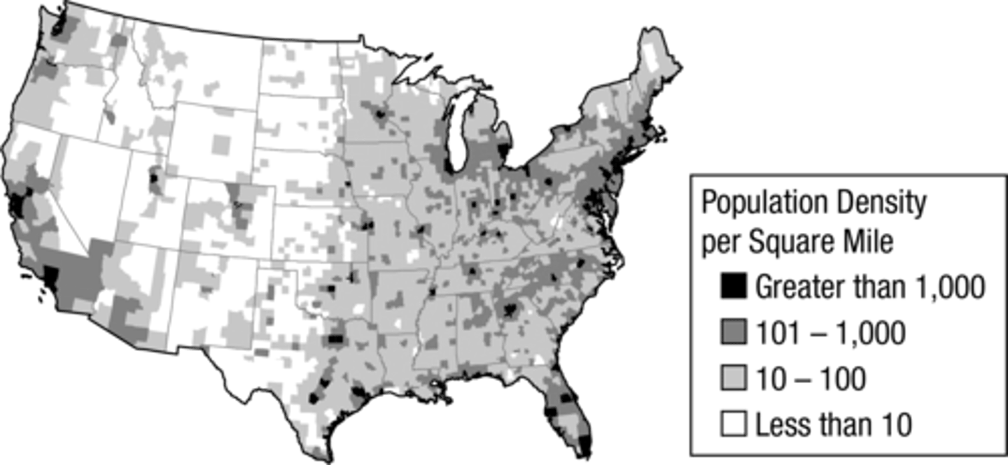
Which of the following patterns is evident on the map of population density?
https://assets.learnosity.com/organisations/537/VH919220.g02.png
A. The Appalachian Mountains are less densely populated than the Rocky Mountains.
B. The Midwest is much more densely populated than the Southeast.
C. The Great Plains are less densely populated than the Midwest.
D. The Pacific Coast is far less populated than the Atlantic Coast of the United States.
E. The Rocky Mountains are more densely populated than the Southwest.
C
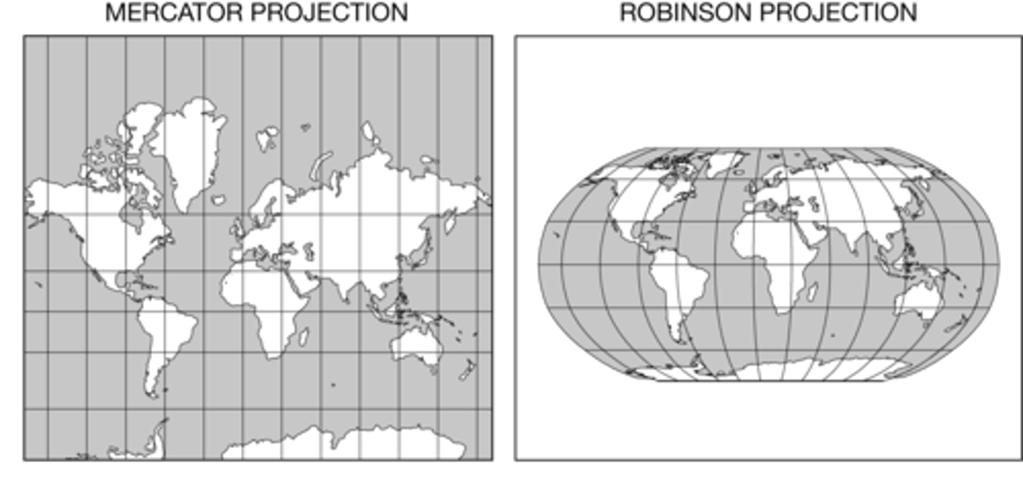
Which of the following statements is an accurate comparison of the two map projections shown?
A. The Mercator projection accurately shows direction but distorts the size of some areas compared to the Robinson projection.
B. The Robinson projection accurately shows direction but distorts the size of some areas compared to the Mercator projection.
C. The Mercator projection accurately shows distances but distorts direction compared to the Robinson projection.
D. The Robinson projection accurately shows shapes but distorts direction compared to the Mercator projection.
E. The Mercator projection accurately shows area but distorts shapes compared to the Robinson projection.
A
Which of the following map types is shown?
A. Isopleth
B. Choropleth
C. Dot density
D. Reference
E. Topographic
B
The data presented in the map shown depict
A. latitude in a Robinson projection
B. longitude in a Mercator projection
C. population in a cartogram
D. elevation topographic map
E. taxation in a flow-line map
C
In his book My Tears Spoiled My Aim, John Shelton Reed explains the difficulty of defining the American South.
"Where is the South? . . . The South is, to begin with, a concept—and a shared one. It's an idea that people can talk about, think about, use to orient themselves and each other. People know whether they're in it or not."
Based on Reed's explanation, the South is best described as which kind of region?
A. Functional
B. Formal
C. Vernacular
D. Peripheral
E. Linguistic
C