Quick Quiz Questions
1/20
Earn XP
Description and Tags
Available Questions for 3/19
Name | Mastery | Learn | Test | Matching | Spaced | Call with Kai |
|---|
No analytics yet
Send a link to your students to track their progress
21 Terms
Where should you move to if you wanted to live in a region with the greatest annual range of temperature? What if you wanted to live in the region with the lowest annual temperature range? What are the qualities that create each of these situations?
greatest range: poles, high in altitude, continental
lowest range: equator, low in altitude, near the sea
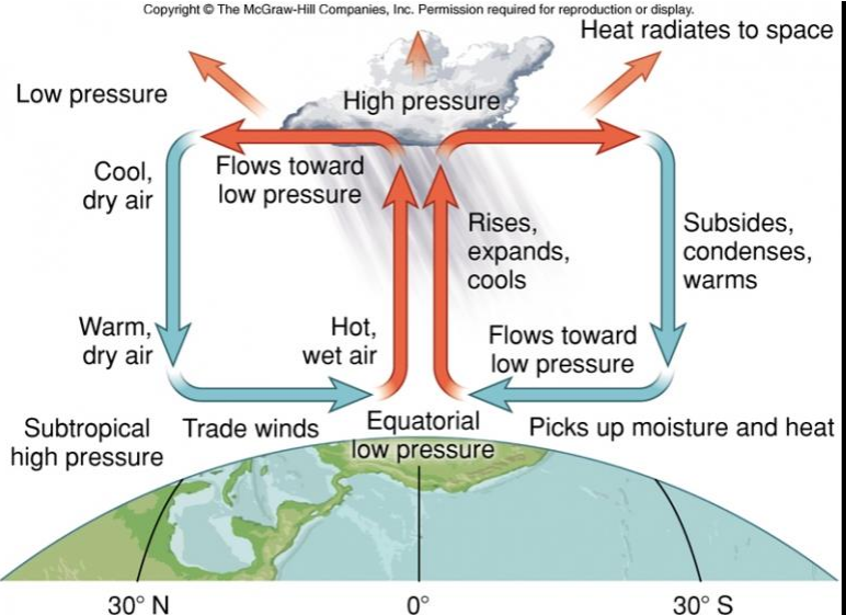
Why are the majority of the earth’s deserts located near 25-30 N/S?
This is a result of global atmospheric circulation. Hot, wet air at the equator rises and then flows towards the 30 N/S where it then condenses and turns into warm, hot air when it hits the subtropics.
Describe the formation and characteristics of both surface ocean currents and deep ocean currents. Consider what the primary drivers are.
Surface Ocean Currents: Driven by global winds. Moves warm water towards the poles and cold water to the equator.
Deep Ocean Currents: Wants to produce very dense water. Differences in density caused by differences in temperature and salinity produce these.
List and briefly describe the four types of atmospheric lifting and given typical geographic characteristics associated with each.
Convergent Lifting: air flows towards an area of low pressure. Southeast and northeast trade winds along the equatorial region making ITCZ
Convectional Lifting: Local surface heating causes warm air to rise. Onshore winds from Atlantic Ocean and Gulf of Mexico
Orographic Lifting: air is lifted upward by a barrier. Often happens in mountains ranges like Hawai’i and India.
Frontal Lifting: warmer air is lifted upwards by cooler air. Continental and maritime air masses
At what point does groundwater utilization become groundwater mining? Give at least one example of a mined aquifer and identity human actions and natural events that might reverse this trend.
It becomes ground water mining when we pump water from a well to the surface (when the pumping rate exceeds the recharge rate). One mined aquifer is the high plains aquifer in North America. If we stopped groundwater mining, eventually (1000+ years), it would recover. If we groundwater mined at a better rate (a rate closer to the recharge rate, it’s likely we can’t match this rate because it would take so long). Natural events like a lot of rain fall would potentially reverse this trend.
The Gulf of Mexico is often home to dead-zones during the summer. Explain what a dead zone is, the process by which it occurs, why it occurs in the Gulf of Mexico, and potential ways humans can mitigate this issue (if at all). For full credit, some biogeochemical nutrients will need to be included in the discussion.
A dead zone is an area in deeper water where the ecosystem dies. Fish avoid the area or die in massive numbers. Tiny organisms that form the vital base of the Gulf Food chain also die. It occurs in the Gulf of Mexico because of the warm freshwater runoff from the Mississippi River. During the spring, sun-heated freshwater runoff from the Mississippi River creates a barrier layer in the Gulf, cutting off saltier water below the contact with oxygen in the air. Nitrogen and phosphorus from fertilizer and sewage in the freshwater layer ignite huge algae blooms. When the algae die, they sink into the saltier water blow and decompose, using up oxygen in the deeper water. Starved of oxygen and cut off from resupply, the deeper water becomes a dead zone. We can mitigate this issue through decreasing what we put in our runoffs, especially if we decrease the agricultural aspect of our runoff.
Tropical Rain Forest Climate
Tropical Monsoon Climate

Tropical Savana Climate
Humid Subtropical Climate
Marine West Coast Climate
Mediterranean Dry Summer Climate
Humid Continental Hot Summer Climate
Humid Continental Mid Summer Climate
Subarctic Climate
Tundra Climate
Tropical/Subtropical Hot Desert Climate
Midlatitude Cold Desert Climate
List the three basic rock types, describe how each rock type is formed, and list any rock-type subcategories.
Igneous: Melts under high temperature and pressure. There's intrusive and extrusive
Sedimentary: forms from fragments of eroded rocks that are deposited at low-lying areas and then compacted to form new rocks. Subcategories include chemical, organic and classic.
Metamorphic: forms under tremendous pressure and heat of any rock. Involves chemical and physical properties changes. No subcategories
Describe the three types of convergent plate boundaries and their typical orogenesis (what landforms they create)
Convergent: two plates pushing into each other Ocean-continental creates volcanic mountains, ocean-ocean creates volcanos and ocean trenches, continent- continent creates mountains
Discuss why short-term predictions of earthquakes are not yet entirely reliable, while volcanoes are more easily predicted.
Volcanos give more warning signs than earthquakes. With volcanos, there are normally elevated emissions of volcanic gases, earthquakes, and ground deformations. Earthquakes don't give signs beforehand. With earthquakes, we just calculate how long it's been since the last one (probability)