Distinctive landscapes
1/63
There's no tags or description
Looks like no tags are added yet.
Name | Mastery | Learn | Test | Matching | Spaced | Call with Kai |
|---|
No analytics yet
Send a link to your students to track their progress
64 Terms
Define landscape
Landscape is the visible features that make up the surface of the land
What are the different elements that make up a landscape. Give examples
Human such as buildings and other man-made structures
Physical/natural which include mountains, coastlines, rivers, climate, geology
Variable such as weather, cloudscapes, smells and sounds. They can also be temporary such as frost in the morning
Biological which is living things like vegetation and wildlife but also habitats such as salt marshes and hedges
What is a built landscape
Landscape with more human than physical features overall
What is a natural landscape
A landscape with more physical than human features overall
What is a distinctive landscape
Having specific landscape qualities that set it apart from others
What are igneous rocks
Igneous rocks are volcanic rock made from molten material brought up to the Earth's surface and cooled into solid rock. There is intrusive igneous rock which is where the magma is cooled within the Earth's crust and is below the surface and extrusive igneous rock is above the surfacw when the magma is cooled on top of Earths surface.
They are harder than sedimentary rock but not as hard as metamorphic rock.
Examples: granite basalt, pumice,obsidian
What is Sedimentary rock
Made up from broken fragments of rock that have been worn down by weathering on earth’s surface. It is deposited in layers called strata and they are often found underwater.
They can contain fossils within their layers
They are the only rock that are porous so they allow water to pass through them.
Examples: sandstone,coal, lime stone
What is metamorphic rock
Metamorphic rock is folded and distorted by heat and pressure as Earth’s tectonic plates move
They are denser and more compact and are hard.
Examples are slate, marble and serpentine
What is hydraulic action
The force of water acting against the bed and banks causing material to be dislodged and carried away
Define erosion
Erosion is the wearing away of the land
What is abrasion
This is the process by which the bed and banks are worn down by the river/sea load. The river throws its particles against the bed and banks sometimes at high velocity
What is attrition
Material carried by waves/river/sea bump into each other and so are smoothed and broken down into smaller particles
What is corrosion
This is the chemical action of the river water. The acids in the water slowly dissolve the bed and the cliffs banks.
What is traction
Large boulder-like particles are pushed along the bottom of the river/sea bed by the force of the water
What is Saltation
Saltation is pebble sized particles (bigger than suspension particles) are bounced along the river/sea bed by the force of the water
What is suspension
Small particles are carried along by the water. They are “suspended” in the water and don’t touch the river/sea bed
Whar is solution (transportation process wise)
Soluble materials dissolve in water and are carried along
What is glaciation
The process or state of land being covered by ice sheets
What are U-shaped valleys
Land that has been shaped by glaciation, where the ice has carved huge amounts of upland areas. They have steep, straight sides and a flat bottom and are formed when a glacier travels across and down a slope, carving the valley by the action of scouring
What is the Quaternary period
The time period in Earth’s history that began about 2.6 million years ago and continues todaay; includes the Pleistocene epoch and the Holocene epoch
What is river deposistion
When a river loses energy, it will drop/deposit some of the material it is carrying.
Deposition may take place when a river enters an area of shallow water or when the volume of water decreases - for example after a flood or during times of drought.
Deposition is most common towards the end of a rivers journey at the mouth. Deposition at the mouth of a river can form deltas
What is coastal deposition
When the sea loses energy, it drops the sand, rock particles and pebbles it has been carrying. Coastal deposition happens when the wash in stronger than the backwash and is associated with constructive waves.
Coastal deposition is likely to occur when waves enter an area of shallow water or a sheltered area (e.g cave, hook, bay), when there is little wind or when there is a good supply of material
how is igneous, sedimentary and metamorphic rock spread across the UK
Igneous - Scotland, Northern Ireland, Wales and Lake district
Sedimentary - England, Wales and lowland Scotland
Metamorphic - Scotland and North Wales
What is freeze thaw weathering
A type of mechanical weathering
1) Rainwater falls in between cracks of rocks and settling within the crack unable to seep through it
2) Temperature change occurs and water freezes into ice. As water freezes it expands pushing the rocks out futher from eachother
3) The ice continues to expand until the rock splits into multiple pieces and breaks down.
What is chemical weathering
Process of which rocks are broken down by chemical reactions
Rain dissolves CO2 in the air, forming weak carbonic acid, acid rain.
Limestone and chalk both composed of calcium carbonate, slowly dissolve in acid
This can create limestone pavements like the one seen in Malham Yorkshire
What is biological weathering
Weathering caused by plants or animals. For example
Tree roots can force their way into rocks splitting them apart.
Smaller plants, like mosses, grow on the surface of the rock, slowly making it crumble.
Animals burrow into softer rocks and people also have an effect with their trampling feet
What is mass movement and the two types of it
Mass movement refers to the sudden movement of materials down a slope due to the pull of gravity.
Heavy rain soaking into permeable rocks can add weight to them and the water can also lubricate the boundaries where material meet so that flow is more likely as the cliff ‘fails’.
1) Rotational slumping occurs om soft cliffs where the base moves and other materials slumps down the face as the bottom moves outwards
2) Rockslides happens where the failure occurs along a geological boundary within the cliff. A section falls down due to gravity and may dislodge other materials on its way. Caused by prolonged wet weather or alternately dry weather where clay shrinks.
Whats the difference between erosion and weathering
Weathering happens in situ (in one place) whereas erosion removes the material from an area
What are the two main type of waves and explain their characteristics
Destructive waves
Large wave height and short wavelength
Weak wash because they break down with great force
High frequency (13 to 15 waves per minute)
Strong backwash due to strong downward energy
Anything one metre or above
Constructive waves
Flat and low in height
Strong wash carries material up the beach
Low frequency (6 to 8 waves per minute)
Wave energy dissipated over it’s wide area which results in weak backwash
Anything under a metre
What is longshore drift
The overall movement of material along a beach, consisting of swash (movement of material onto the beach) in the prevailing wind direction and backwash (movement of material off the beach) at a 90° due to gravity
What is a beach profile
A cross section of the beach from the top of the beach (part closest to land) to the seashore (part closest to sea). It shows how steep the beach is depending on how steep the profile gradient is. Sandy beaches usually have flat gentle profiles while pebble beaches tend to have much steeper profiles.
Explain the formation of a beach
Deposition is the main process that creates a beach
Deposition occurs where waves have limited energy so beaches often form in sheltered areas such as bays where the waves are likely to be constructive so material is deposited and overtime this material will accumulate. Beaches are under constant change via processes such as longshore drift
Explain the formation of Criccieth bay
Criccieth has a discordant coastline made up of alternating bands of hard rock ( volcanic rock at castle headland and igneous intrusion of Basalt at black rocks headland) and soft rock (soft glacial till at the bay). Erosion happens at the coast by processes such as hydraulic action and abrasion but the soft glacial till is unconsolidated and less resistant so erodes at faster rate of 1 metre every 10 years. This creates an area of retreated land, Criccieth bay.The hard rocks beside the bay is more resistant and erodes at a slow rate of 1mm every 100 years which leaves the black rocks headland and the castle headland jutting out to sea
Where is Criccieth
North wales
What is the fetch of Criccieth bay
It’s exposed to a 7,000km fetch across the Atlantic meaning the waves carry a large amount of enegry
How are wave-cut platforms formed. Give a place where this is seen
1) Weathering such as freeze thaw weathering weakens the top of the cliff
2)The sea attacks the base of the cliff by hydraulic action and abrasion which forms a wave cut notch
3) The notch increases in size causing the cliff to collapse
4) The backwash carries the rubble back to the sea forming a wave cut platform
5) The process repeats itself and the cliff continues to retreat
Seen in Seven Sisters in Sussex and Black Rocks headland in Criccieth has wave cut notches but no visible wave cut platform
Explain formation of caves, arches, stacks and stumps. Give a psd of where this can be found
1) The sea attacks small cracks at the base of the headland/cliff via hydraulic action.
2) The crack gets larger due to weathering and more erosion developing into a wave-cut notch and then into a cave.
3) Erosion on both side of the headland depends the cave and if two caves are aligned, the caves break through via abrasion and forms an arch
4) The roof of the arch is worn away over time by weathering processes such as freeze thaw weathering, biological and chemical. This makes it unstable and eventually it collapses under it’s own weight to form a stack.
5) The base of the stack is attacked by erosional processes such as abrasion, solution and hydraulic action causing it to topple over.
There is a stack to the east of black rocks headland and a stump to its eastern end. There is also caves on black rocks headland. There is also a stack at Old Harry along the Dorset coastr
Explain the formation of a spit. Name a place where a spit can be found
1) Longshore drift moves material along the coastline in the direction of the prevailing wind
2) If the coast changes direction, the material will still be moved via longshore drift but in shallow sea. This means material will be deposited
3) This buildup of material is called a spit.
4) Over time the spit grows and if there is a short term change in wind direction further out, it develops a spit.
5) Wave can not get past a spit so a sheltered area is created where silt is deposited and mud flats or salt marshes can be formed
It can be found in Spurn Head along the Holderness coast in Humberside
What is a tombolo and bar
Tombolo is where a mainland joins an island via a spit
A bar is where a spit connects two parts of mainland.
What are some coastal managment strategies at Criccieth and explain them.
Timber Crib wall and Rock Amour Revtment - Located at the west end of Criccieth shore. the timber Crib wall is composed of grid wooden planks with stones behind it that that are around 5cm in diameter. it hold the cliff in place but allows saturated clay to drain to prevent slumping and mass movement. the crib wall alone doesn’t offer total protection so a rock amour is built at base of the timber Crib wall. It consists of large boulders imported from Norway, around 1m in diameter and it breaks up and disssipates wave energy before they reach the base of the crib wall. For both it cos £271,000 for an 80m stretch of coastline but it protected £1.6 million worth of properties.
Groynes - Found on the western side of the castle headland. Traps sediment being moved by longshore drift which enarges beach and promotes tourism. The larger beach then absorb wave energy and prevents land behid. However due to the interruption in longshore drift, there is more erosion somewhere futher along the coast.
Breakwater - Reflects wave energy away form shore and turns destructive waves into constructive waves through wave refraction. Was built in 1900s but would cost over £500,000 to build today. It promotes fishing
Other:
Victorian sea wall
Recurved sea wall
Do nothing (soft engineering) - at more resistant parts of Criccieth coast
What is a drainage basin
It is the area which is drained by a river and it’s tributaries. It is an open sytsem
What is a catchment
The area of land from which the water drains into a particular basin.
What is a watershed?
The boundary dividing one drainage basin from another
What is a river source
The upland area where the river begins
What is a tributaryu
A river which joins a larger river
What is a confluence
The point at which two rivers join
what is a river mouth
Where the river flows into the sea or sometimes a lake
How does the load of the river vary at different points
Upper course - hasn’t been broken down by erosion yet so larger and more angular rocks. Transportation via traction.
Middle course - starting to broken down, a mix of coarse and fine materials. Rocks carried by saltation and suspension.
Lower course - finer sediment like sand,silt and clay. lower river energy so less ability to transport large pieces of material. More solution and saltation
What are some features of an upland area in a drainage basin you have studied
Interlocking spurs
V- shaped valleys - migneint moors
Meanders and ox-bow lakes (unusual) - nant-y-brwyn
How are interlocking spurs formed
1) When a river encounters areas of hard resistant rock, it is unable to erode through them as easily as softer rock.
2) Instead of eroding directly through the hard rock, the river is forced to bend and flow around these obstacles.
3) As the river erodes around the hard rock, the land on either side of the river channel is left as projecting spurs.
4) These spurs appear to interlock in a zig-zag patteren when veiwed from down stream
How are V-shaped valleys formed
Vertical erosion via hydraulic action and abrasion depeens the river channel and pushes it downwards leaving steep banks.
This leaves the bank very open to weathering and causes it to be unstabe.
Eventually mass movement moves lose material down towards the river
Sediments fall into the river and a V-shaped valley is left
The process repeats as more load is added to the river giving it more power to erode and eventually the V-shaped valleys start to erode laterally as well
How are meanders and ox-bow lakes formed. Include detail about slip off slopes and steep sided river cliff
Usually formed in lower course but found in flatter lands of upper course in Afon Conwy due to past glaciation.
1) A relativley straight river begins to curve due to a slight difference in the river bed or a small obstacle.
2) On flatter land, there is more lateral erosion and water is pushed to the outer bend
3)The current of the water is stronger on the outer bend and it has a greater velocity, leading to more lateral and vertical erosion via hydraulic action and abrasion. This means there is less friction (if the river is deeper, less of the river load is touching banks) so river is fatser
4)The high erosion undercutts the outer river bank and creates a steep sided river cliff.
5) Water flows slower on the inner bend as it is a low energy zone and has a shallower channel. The shallow channel means more friction (more of the river load can be in contact with the riverbed) and therefore slows down the speed of the river.
6) There is less energy on the inner bend so sediments is deposited creating a gentler gradient called a slip off slope
7) As the outer bend becomes more eroded the gap between the two outer bends move closer and the neck of the meander narrows.
8 ) In a time of high water flow or a flood the river breaks through the narrow gap and forms a straigher path where the two outer bends meet with a small circular flow of river next to it but still attached.
9) Eventually current along straighter path becomes more dominant and the abanoded meander is called an ox-bow lake
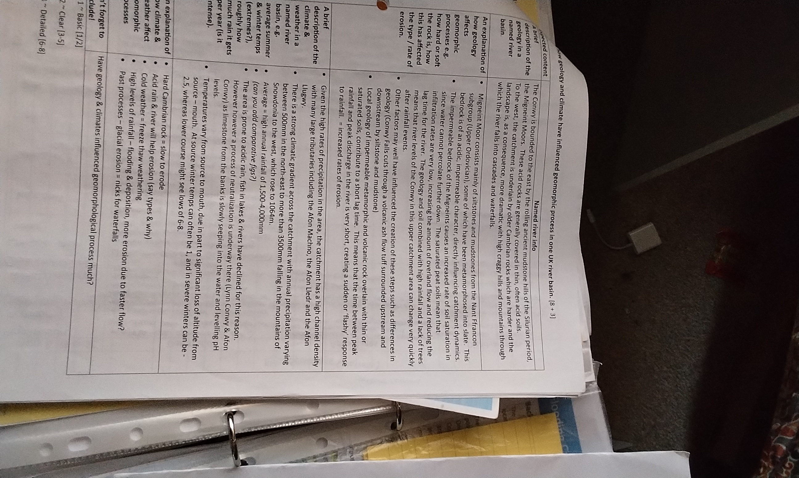
How has erosion influenced distinctive landforms in the middle course of Afon Conwy.
The Conwy falls in located in the middle course due to past glaciation.
1) Hard volcanic felsic tuff is layered on top of exposed soft mudstone and sandstone.
2) As the river flows, the more resistant hard volcanic felsic tuff rock doesn’t erode but once the river river reaches the exposed softer rocks (mudstone and sandstone), it begins to erode via hydraulic action and abrason is creating a very steep sudden gradient
3)The river falls and continues to erode the mudstone and sandstone undercutting the volcanic felsic tuff creating a ledge and plunge pool underneath
4) The ledge of volcanic felsic tuff eventually collapses under it’s own weight into the plunge pool creating more erosion via abrasion
5) The waterfall continues to move back as the process repeats and creates a steep sided gorge overtime which extends all the way to Betws-y- coed
What are some features in the lower course of Afon Conwy. Explain them
Floodplain - an area of land formed by lateral erosion and deposition. Lateral erosion creates a wide, flat area of either side of the river. During a flood material carried by the river is deposited. Larger sedimiments are deposited close the channel,on the river banks. Smaller sediments are carried futher out, increasing the height of the floodplain. The process continues and the large sediments deposited on the river banks build up to create levees
How is a delta formed
At the mouth of a river the river is carrying too much load for its velocity so deposition occurs. Firstly the courses river load is drop and then the final particles occurred into the deeper water and dropped. overtime the deposited sediment builds up and creates a delta.
Found in the lower course
What is an estuary
An area of freshwater that meets the salt water in the ocean forming are transition zone between the river and the sea
What are the negative and positive impacts of the human activity in Afon Conwy
In the upper catchment of athlon Conway there is lots of farming of shhep and more mixed livestock farming in lower sections. Farming creates pollution which enters the rivers and can alter watercolor or create algae but Farming also prevents urbanization and prevent preserves the landscape.
The conwy catchment is an important salmon and sea trout fishery which encourages tourism for fishing. The catchment is used for other recreatiional activities such as canoeing and hiking and climbing which can encourage tourism. Tourism can lead to biological weathering, weakening landforms.
historical clearance of trees for agricultural purposes impacts on the amount of rainfall stored temporal really unsurfaces such as leaves before reaching the ground (interception) and on the amount of water moving down into the soil (infiltration) . Reduction in these processes decreased lag time and increases flood risk to landscape
a tunnel was built under the estuary to relieve traffic congestion this means the river was rerouted which visibly changes the landscape and water now enters Afon Conwy faster increasing flood risk
staff from the National Trust are tarting to restore the mignient blanket bog. Peatland restoration can help enhance wildlife habitats and restore species diversity. peat soils also lock in about 3 billion tons of CO2 .
What are geomorphic processes
Erosion, weathering, mass movement, deposition and transportation
What influence does climate has on Afon Conwy
The high rates of precipitation increases the channel density. The area is also prone to acidic rain which reduces the fish in lakes and Rivers. It also increases chemical weathering. The cold weather increases freeze thaw weathering. The high levels of rainfall increases flooding and deposition. Past glacial erosion creates nicks for waterfalls. Lost of tributaries due to high precipitation
What are some psd of Afon Conwy
In north wales. Begins in migneint moors and ends in Conwy estuary.
Source is at Llyn Conwy and is a reseviour 450m above sea level and has a length of approx 2m.
Has a large catchment area of approx 590km²
Large tributaries such as Afon Machno and Afon Llder
High Channel densisty
What are the geology and soils like on migneint moor
Consists on mainly silstones and mudstones from Nant Franco subgroup, some of which has been metamoprhised into slate.
The bedrock is acidic and impermeable.
Creates peat soils because of cold climate due to high altitude and saturated soils and water can’t reach impermeable rock.
This reduces lag time and increases flood risk
What are the river defences put in place in Afon Conwy
Llanwrst is a historical market town in the middle course of Afon Conwy. Implemented a £7million defence scheme which has saved 96 homes and businesses. It’s 3 main defences are:
Floodplain zoning and levees - A type of soft engineering that utilises the recreational and agricultural land to the west of Afon Conwy as a storage area for floodwater. Reduces the risk of flooding to the town centre and residential areas on the East banks. Artificial levees are also placed in series to direct flow of water in desired direction which provides refuge for life stock in times of flood. It is also a cheap cos. However it can look unpleasant and speed up water and increase risk downstream.
Artificial flood culvert-the Afon Bach goes through the central business area so a 720m long underground tunnel was built to link it with Afon Conwy. In high flows, excess water enters the culvert and bypass the town centre. It protects twon centre but it was very expensive and costs £2M and puts even more pressure on Afon Conwy in times of flood
Dutch Dams - Temporary flood barriers . Expensive and costs £750,000 and can’t withstand severe floodig
Name some river Managment strategies
Floodplain zonation
Leveees
Artificial Flood culveret
Dutchdams
Improved flood prediction/ flood warnings
River straightening - speeds up the water so more volume of water can pass through area quickly but on creases flood risk downstream
Dams and Reservious - traps water and builds up behind dam forming a reserviour. can be used to produce electricity by putting turbine in dam and reserviours can attract tourists but is expensive and causes displacemnet. Can also flood habitats and rot vegetation causing methane release
Planting trees - interception reduces flood risk
How has geoglogy and climate influenced geomorphic process in Afon Conwy