Geography Topic 4 - The storm(flood) hydrograph
 Call Kai
 Learn
Learn Practice Test
 Spaced Repetition
 Match
Match Flashcards
 Knowt Play
1/12

There's no tags or description
Looks like no tags are added yet.
Name | Mastery | Learn | Test | Matching | Spaced | Call with Kai | Chat |
|---|
No analytics yet
Send a link to your students to track their progress
13 Terms
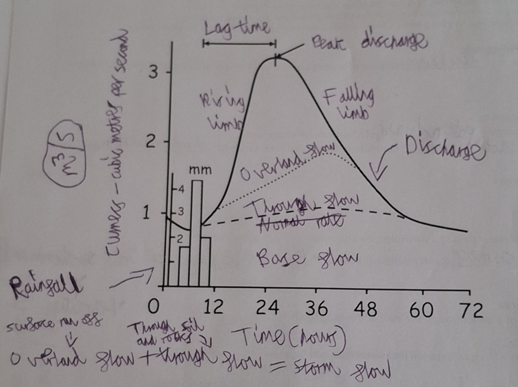
What is a storm flood hydrograph
A graph showing the change in discharge caused by a period of rainfall
Discharge is measured in cumecs - m3/s
Here is an example of a storm flood hydrograph
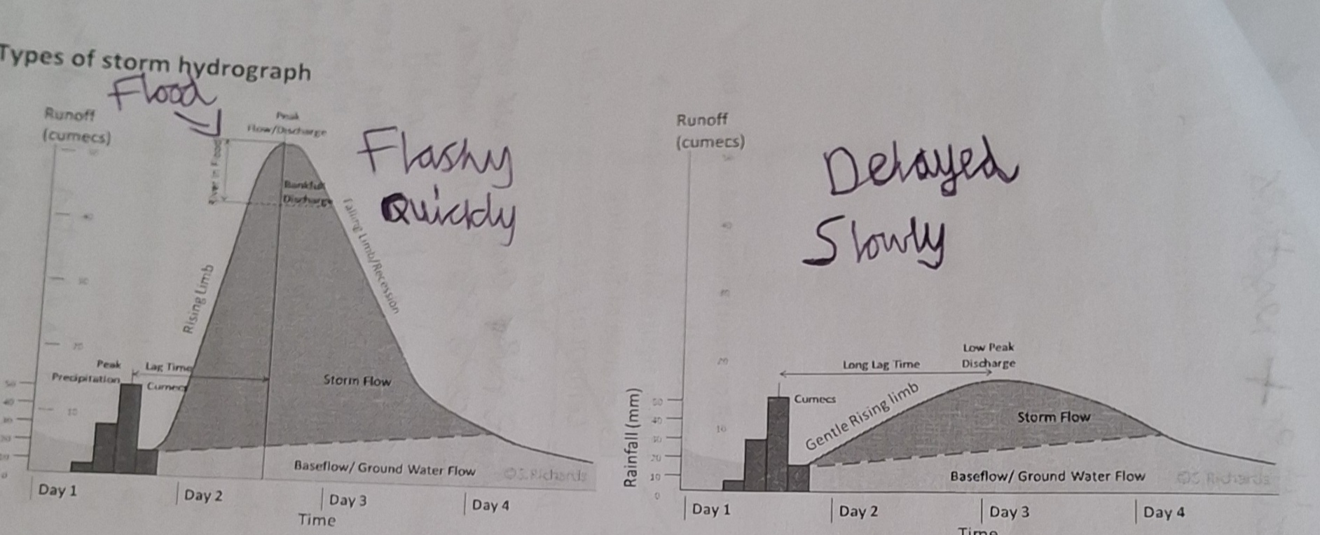
Here is what a flashy and delayed storm hydrograph look like
Factors that affect storm hydrographs
Rock type and geology-impermeable rock means more overland flow
Soil-Well drained sandy soils mean less overland flow
Land use-Urban surfaces and agriculture limit infiltration resulting in high peak discharge, short lag time and a flashy hydrograph
Drainage density-higher density means it is better drained so less chance of flooding
Precipitation/temperature-heavy and prolonged rainfall means soil becomes saturated
Tidal conditions-High tide means water struggles to leave the river system into the sea so more water in DB
Drainage basin area-Large drainage basin means more lag time
Drainage basin shape-Rounded means shorter lag time. Elongated means longer lag time
Slope/gradient-Steeper valley sides means faster overland flow and short lag time
Agriculture affects on water cycle
Irrigation-more evotranspiration in desert area, river levels drop, soil moisture increases
Abstraction-River levels drop, water shortages downstream
Pesticides-Washed into and pollute rivers, poison wildlife
Overstocking with lifestock-Overgraze means less vegetation, compacted ground because of trampling, less infiltration and more runoff
Natural vegetation removed-less interception, more saturated soils so more runoff
Land use affects on water cycle
Urban heat island effect-dark urban surfaces absorb suns energy and radiate heat causing convectional uplift, Causes thunderstorms and heavy rainfall
Sewage into rivers-pollutes river and increases discharge
Drainage systems-Catch rainfall and decrease lag time
Concrete and tarmac-impermeable, no infiltration, no throughflow, increased runoff - flashy storm hydrographs
Reasons for deforestation
Economic benefit - cattle feed, beef, sugar cane and ethanol
How and why do farmers use drainage systems
They use tiles, tubes underground - to remove excess water from the soil profile to help their crops grow
How do the tiles (tubes underground for drainage systems) work
When the water in the soil is higher then the tile, water flows into the tubing which lowers the water table to the depth of the tile over several days. No water is removed if water levels are below the tiles
Advantages and disadvantages of soil drainage
Advantages: Increased productivity and economic outputs
Disadvantages-Increased throughflow, decreased lag time, increased discharge and increased chance of flooding downstream
What happens when nitrogen and phosphor from agriculture enter rivers and ponds
It enriches them so algae and plants grow too fast. This causes them to block sunlight so all organisms in the pond die
What is water abstraction
People pump water from the groundwater store to use. It is most common in areas of low rainfall, high population density, intense agriculture and intense industrial activity
Effects of people taking water out of the ground faster then rainwater replenishes it
Water tables sink, empty wells, intrusion of salt water and ground water contamination