Coastal Environments Test 2
1/88
There's no tags or description
Looks like no tags are added yet.
Name | Mastery | Learn | Test | Matching | Spaced |
|---|
No study sessions yet.
89 Terms
coastal sediment sources
sediment is weathered in different ways:
- weathering of rock
- activity of living organisms
- volcanic eruption
- chemical reactions
sediment is carried to coast in different ways:
- rivers
- wind
beach sediment color (red, green, black beaches)
Red Becahses are caused by Iron (oxides into a red color)
Black Beaches are caused by Basalt (Volcanic Sads)
Green beaches caused by Olivine (Volcanic Sands)
sediment grain size analysis method
used to determine average sediment size
sieve analysis
a stack of sieves with large holes at the top, small at the bottom
sediment filters through and at the end you can tell what percentage stopped at each level (what percent of sample is each size)
you can use numerical treatment of grain size, using stats and graphs based on the sieve analysis to determine average grain size
oscillatory flow
as opposed to unidirectional flow
fluid motion reverses direction, flow is turbulent instead of smooth
this is what causes seafloor ripples
happens in ocean and lake waves
when water depth is 1/2 the wavelength or less, the oscillatory flow can contact theh seafloor and move sediment
in deeper areas, oscillatory flow doesn't move sediment
unidirectional flow
as opposed to oscillatory flow
like a river, water that starts in one place and ends in another place
is laminar as opposed to turbulent
sediment transport
difficult to predict how particles will move with flowing fluid
moving water transports sediment, but so does moving air (fluid is any material that is deformable under its own mass, including the atmosphere/air)
things that affect how sediment is moved
these things can be measured to know if coastal sediment will be moved by flowing water
slope
wind direction
wind speed
flow
water speed
water depth
sediment size
water movement affected sediment transfer
tidal currents
- tidal inlets can create sediment transport, like in ebb and flood tides
undertow and rip currents can be important for sediment transport. undertow is the flow of water offshore that pulls sediment out. rip current can carry sand from beach to significant distances offshore
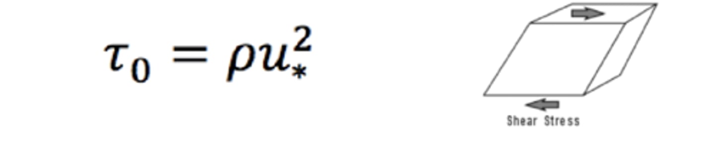
bed shear stress
frictional force exerted by flow per unit area of bed
this controls entrainment and transport of sediment
shear stress parallel to any surface in a material
shear stress is created if principal stresses are unequally distributed
equation for bed shear stress
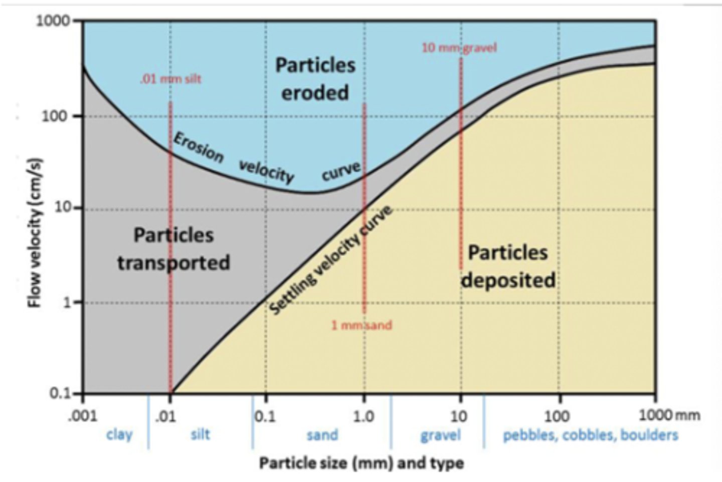
hjulstrom diagram
diagram that shows the function of the force of water and sediment transport
looks at particles transported, eroded, and deposited based on water speed and grain size
grain reynolds number
Increase means increase in grain size, shear velocity & turbulence, or a decrease in kinematic viscosity.
Measures Turbulence of a grain-fluid boundary
helps determine if waves have sufficient energy to carry out erosion in the specified location
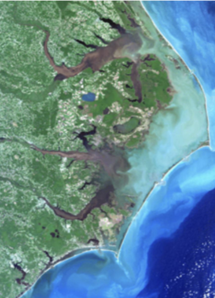
delta
where fluvial river systems meat the ocean
marginal marine or lacustrine systems
the deposition rate far exceeds erosion rate (defined by progradation)
delta size
reflects the type of coastline
depositional coasts on passive margins make larger deltas
- larger drainage basins
- wider continental shelves
- finer sediment
erosional coasts on active margins create smaller deltas
- closer mountain ranges
- narrower continental shelves
- coarser sediment
delta classification
river dominated
wave dominated
tide dominated
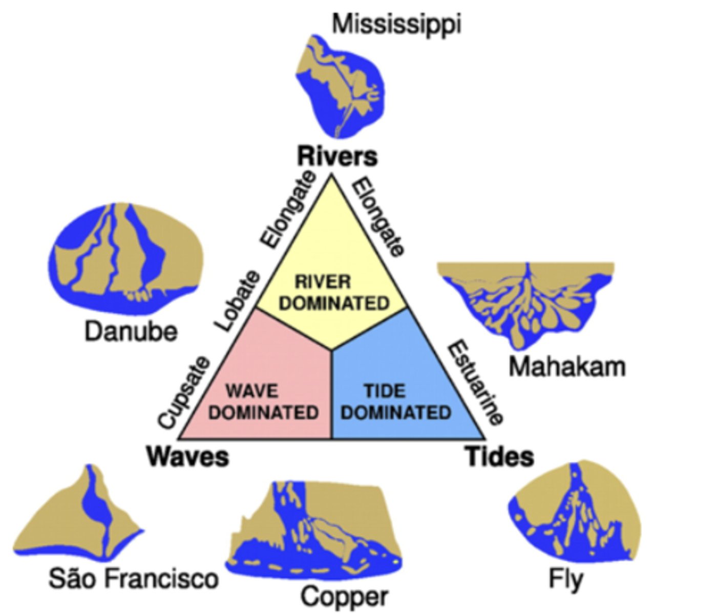
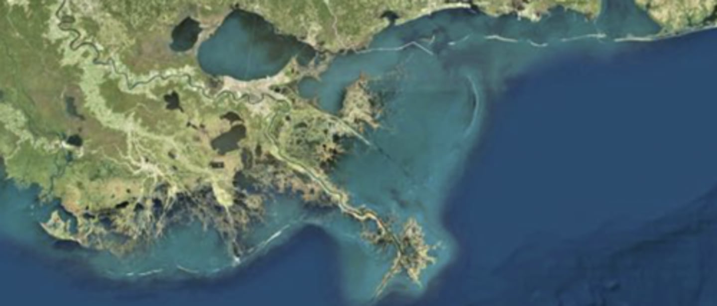
river dominated delta
ex: mississippi river delta
aka "bird's foot delta"
weak tide and current flow
fine grained sediment
distributary channel, deposition dominant
abundant vegetation (marsh/mangrove)
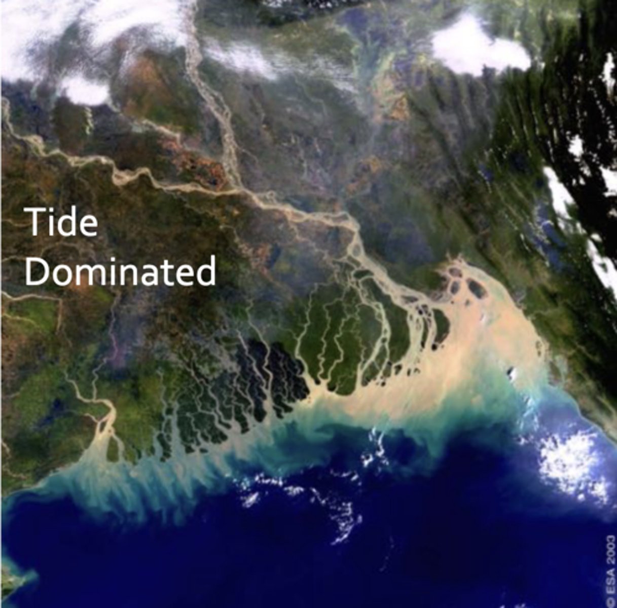
tide dominated delta
ex: ganges brahmanputra river delta
lots of channels perpendicular to shoreline
reason is that there is a high tide range
tide is the most critical mechanism for sediment movement
tidal current velocity is greater than river current
redistribute sediment
linear ridges parallel to flow
grain size gradation
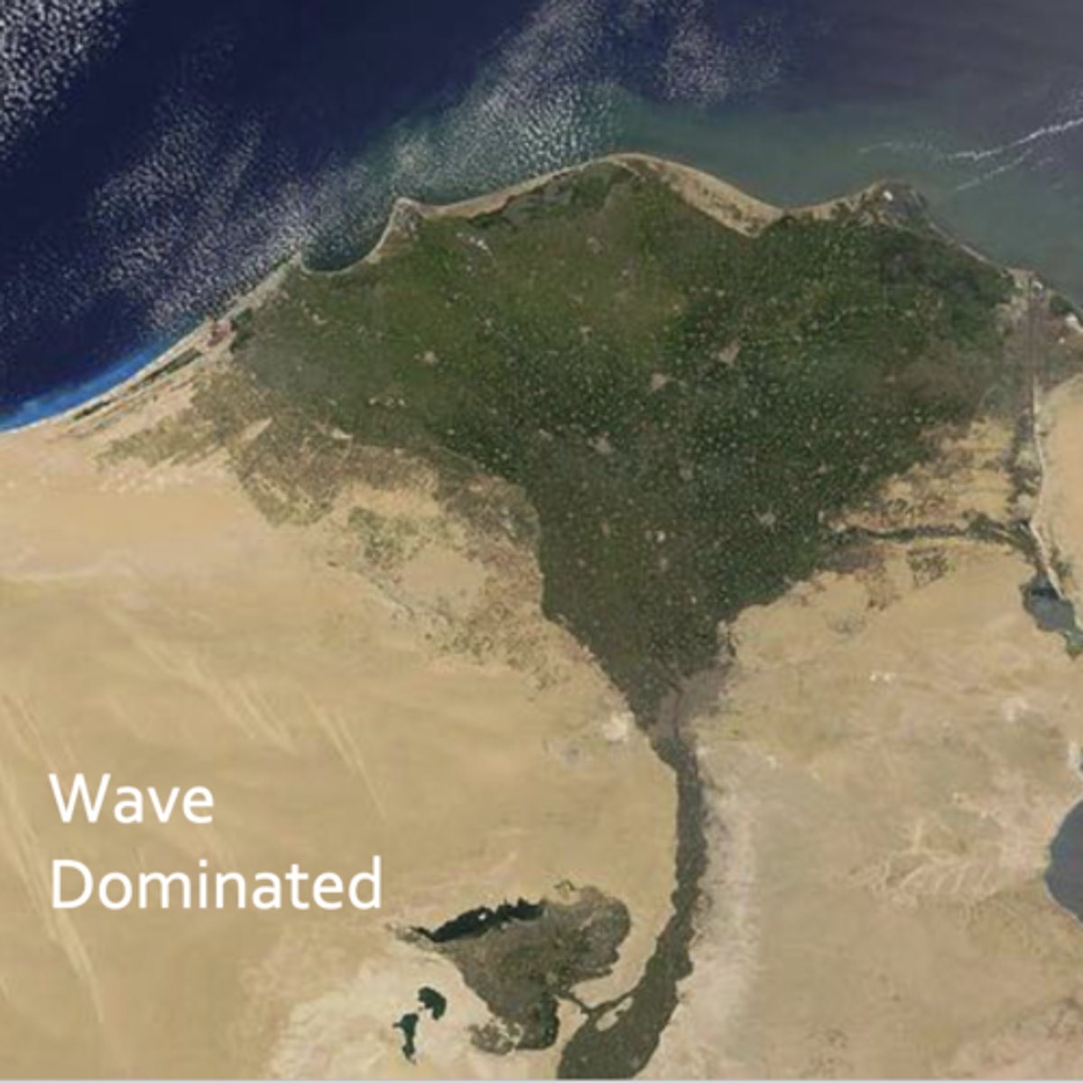
wave dominated delta
ex: nile river delta
waves coming in create longshore transport and smooth the coastline
waves are more powerful than the river channels are in terms of moving sediment
deflect river mouth
beaches, barrier ridges, spits
smooth front
cupsate form
eolian dunes
not very much vegetation
importance of deltas
hydrocarbon deposits/reservoirs
ecologically diverse and productive
major population centers
protection in cases of storms
what influences delta form
climate
slope
river velocity/discharge
sediment load
waves
tides
currents
winds
delta migration
estuary characteristics
partially enclosed body of water
where river systems meet marine systems
defined by transgression (water coming into land barrier)
often flooded river or glacial valley
transition from fully river to fully ocean (continental shelf) processes and conditions
salinity transition from fresh to salt water
bidirectional exchange of sediment, water, nutrients
highest biological productivity on earth
estuarian physiochemical conditions
key concentrations:
- dissolved ions (salinity), dissolved oxygen
- in poorly mixed estuaries there may be less oxygen available
dissolved organic carbon
- food for organisms to eat
- one of the reasons estuaries are so productive, there is ample food available
particulate organic matter
- also food
suspended sediment concentration
- organisms also have different tolerances to sediment concentration
- sediment blocks out light
- sediments bring nutrients
what happens when river systems meet marine systems
salinity distribution can change at any given point in the estuary based on external conditions; during a drought, during areas of more seawater intrusion
mobile animals can move around and find the area in the estuary that suits their needs (sessile organisms are out of luck if the salinity in their area changes)
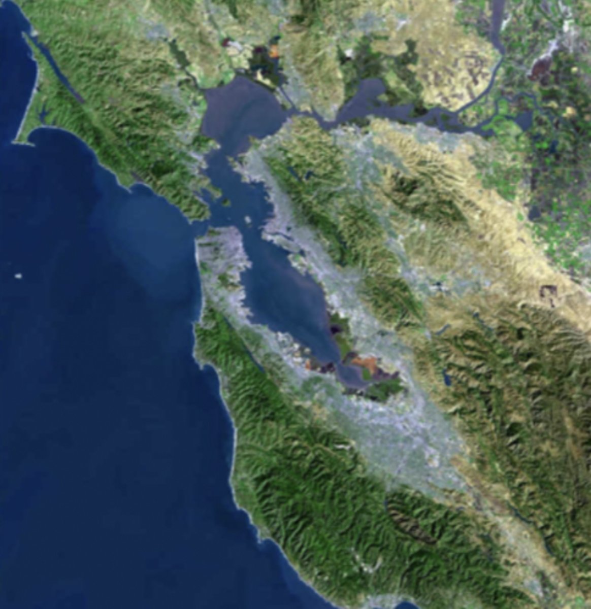
estuary classification by formation/physiography
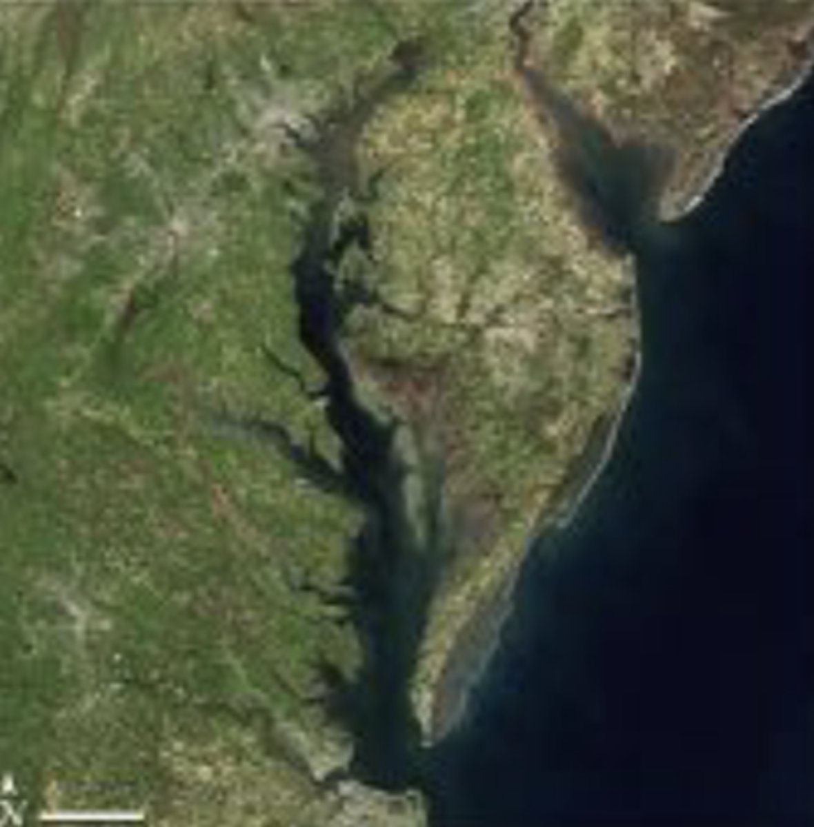
flooded river valley
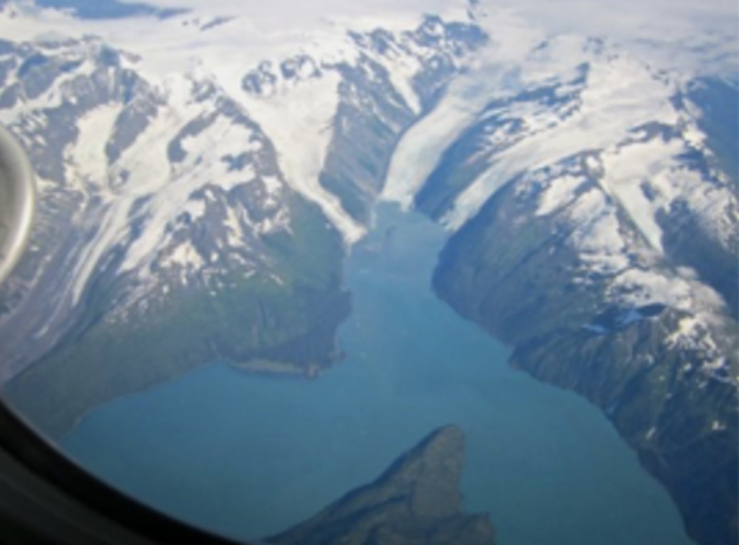
fjord
bar built
tectonic
drowned river estuary
coastal plain
passive margins
tectonic estuary
movement created a low spot that is now filled with water
fjord estuary picture
these have a glacial origin
bar-built estuary
blind estuaries (barrier islands separate the enclosed estuary from the open ocean)
lagoon
estuary classification by mixing/chemical oceanography
this is based on circulation patterns of salt and fresh water (not on shape)
salt wedge
partially mixed
vertically (well) mixed
stratified
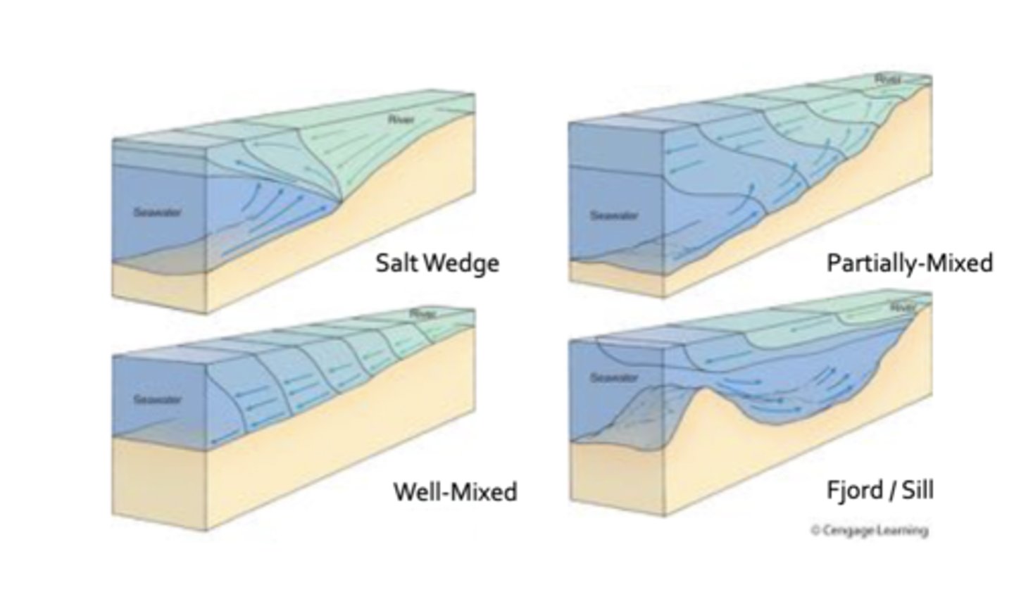
salt wedge estuary
sediment transported seaward
freshwater river output exceeds saltwater input
tides have minimal influence (water is not mixing)
buoyancy puts freshwater on top fo saltwater
partially mixed estuary
minor net transport
well mixed estuary
strong tidal influence (macro to mega tidal)
tidal currents exceed river output
salinity uniformly grades from the river to ocean
fjord estuary
aka stratified estuary
sediment is trapped
estuary is partially blocked by a sediment still preventing water circulation
freshwater is directly on top of salt water
list the four types of estuaries based on mixing and describe them.
List the four types of estuaries based on geography and describe them.
wave dominated estuary
microtidal and poorly mixed
transverse barrier bards common (barrier islands)
blind estuary common
primarily river deposition
not a lot of coastal wetlands
tide dominated estuary
macrotidal and well mixed
sand bars and channels parallel to axis from marine sources
lots of tidal flats exposed during low tide
importance of estuaries
provide natural habitat
economic resource
environmental services
coastal protection
estuaries as natural habitat
biological productivity
thousands of species depend on them to live, feed, reproduce
many marine organisms depend on estuaries at some point in their development
high levels of organic matter, enclosed nature provides protection, microhabitats with lots fo options (created by rising and falling tides, changes in water depths and chemistry)
estuaries as economic resources
commercial value, resources provide economic benefits for tourism, fisheries, and recreational activities
protected coastal waters of estuaries support public infrastructure, serving as harbors and ports
estuaries as environmental services
water draining from uplands carries sediments, nutrients, and other pollutants into estuaries. as the water flows through wetlands such as swamps and salt marshes, much of the sediments and pollutants are filtered out. this filtrations creates cleaner water
salt marsh grasses and other estuarine plants also help prevent erosion and stabilize shorelines
how estuaries provide coastal protection
wetland plants and oils act as natural buffers between the land and ocean, absorbing flood waters and dissipating storm surges
this protects upland habitat as well as valuable real estate from storms and flood damage
beach sediment properties
parent material
weathered continental rock most often delivered by rivers (size depends on competence, volume depends on capacity)
sometimes rock from localized cliff erosion or onshore transport
grain size varies but grains are generally well sorted
mature, rounded, polished, or frosted grains
terrigenous coastal sediment composition
determined by source material
- granite
- volcanic rock
determined by distance from coast
- long distance - more rounded - well sorted
determined by wave energy
- high energy - coarser grains - more rounded - well sorted
dunes
Wind can blow up larger dunes than water can create sedimentary features under the surface
Can reach over 1000 meters tall in some locations

beach morphology
erosional coasts: cliffs, rocks, pocket beaches
depositional coasts: sediment
in areas with large boulders: likely some eroding rocky headlands that are breaking down into boulders, rolled around and smoothed off by waves
in gravel beaches: smaller but still course, well sorted sediment; could be from a river or could be from gravel deposits behind beach
beaches like GoM
- carbonate and siliceous beaches
- carbonate beaches are made of the shells of living organisms
beaches with reddish-orange sediment: clay, iron presence
constructive waves
Long wave length and low frequency
Ex: swell during fair-weather, calm conditions
Wave slowly breaking onto beach without very much curve
Water has a "strong swash" - moves up high on the beach with a weak backwash
Usually more in the summer
During periods of constructive waves, sediment from greater depth than ½ wavelength is not being moved
destructive waves
Shorter wave length
Taller waves
As they approach the shoreline, they get taller, break, the wave plunges onto a steeper beach
Wave does not travel as far up the beach
During winter weather conditions, there are usually more storms, higher winds, and more destructive waves
longshore sediment transport
Longshore current
Waves meet shore at angle
Creates longshore transport
Moves sand on the beach in the direction of the longshore current
sediment ripples
They are a common feature of beaches
From oscillatory wave motions over the seafloor
spit formation/migration
Large deposit of unconsolidated material transported by longshore drift
Generally in the form of a peninsula
Build off headlands in the direction of longshore drive
Something carves a channel until the spit is completely cut off
Island continues to migrate
Example: cape henlopen spit in the delaware bay
aeolian sediment transport
sand dunes
Eolian (wind)
dunes formed through fluid migration of wind
three methods of barrier island formation
Longshore transport (sand is carried out along the coast to form a peninsula called a spit, which then breaks off and forms the island)
Sandbars are created, sea level falls, and sandbars are now long, thin islands off of the short
Sand dunes might become islands if the water level rises enough to fill in behind the sand dunes but leave the sand dunes above water
barrier island formation
Make up 13-15% of the world's coastlines
Narrow and long (longest ones in the world are in Texas)
Loose sand, not connected to any underlying substrate
Sometimes will have pockets of marsh/wetlands between the island and mainland (in the "lagoon")
barrier island over-wash processes / migration
Islands move towards the land during large storm events
Will not become part of the shore, the lagoon will still be there
Coastline will retreat as well
often, when a hurricane hits a barrier island, it will carry sediment as an overland flow from the island to the area behind the island
tidal inlets sediment dynamics
Opening in the shoreline that connects ocean to bays, lagoons, at tidal creek systems
Maintained by tidal exchange in and out of semi-enclosed body of water
Most geomorphically dynamic portions of barrier island systems
- Relevant for placement of structures
Migrate along-shore
Interrupt longshore transport of sediment
value of tidal inlets
ecosystem support: pathway for marine species between open ocean and protected estuary/lagoon
commercial and recreational fisheries
marine navigation: access to protected harbors/port infrastructure
inlet formation
Storm wash-over
Waves breach dunes
Inlet cut from back
- Escaping water
ebb/flood tidal shoals
An inlet where sand is carried from outside the lagoon inside, and as soon as it passes into the lagoon the energy of the water lessens and the sediment is deposited
Forms wetlands behind an island (on the side of the mainland)
Over time, inlets move along the island in the direction of longshore transport
lagoons
Highly enclosed coastal embayments
Typically, elongate and parallel to the coast
Often found shoreward of barrier islands or reefs
Typically, little or no freshwater input and minimal tidal exchange
- Means that from a wildlife standpoint, they are "stressed" ecosystems
Restricted flow leads to unique processes and habitats
- Elevated salinity
- Often considered a stressed ecosystem
inlet sediment bypassing
tidal prism
volume of water entering and leaving the inlet every tidal cycle
Approximately surface area of enclosed body multiplied by the tidal range
Fastest flood and ebb tide currents occur in between high and low tides (flood is between the low and high; ebb is between high and low)
inlet migration
Migrate along-shore
Interrupt longshore transport of sediment
tidal flats
Primarily mesotidal and microtidal coasts with minimal wave action (or wave protection)
Low relief coastal environments
Intermittently exposed with tidal cycles
Estuaries, barrier backshores, shorefaces, deltas
Flat sediment (mud) plains cut by a network of drainage channels
Commonly marsh covered in temperate climates
May have mudcracks and evaporites in arid environments
coastal wetlands
low wave energy
- protected by coastal water bodies
variable salinity
- marine and freshwater influence
arial extent
- defined by sediment infilling, wave energy, and tidal range
marsh setting
Play a very important role in climate
Carbon from plants gets locked up with sediment, buried, and then compressed in the earth to become rock
Carbon is sequestered for millions of years
Marshes have LOTS of CO2-consuming plants
The microbes living in the marsh eat organic matter, and the byproduct of that process is methane (marshes release large amounts of methane into the atmosphere)
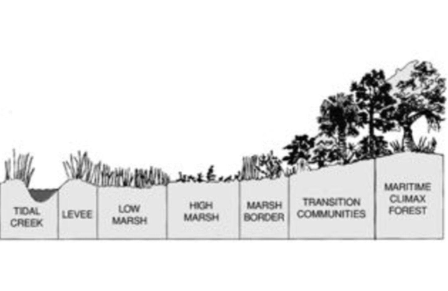
salt marsh vegetation
in temperate areas: salt marsh (salt tolerant grasses)
high marsh
Spartina patens (saltmeadow cordgrass)
- Smaller plants - flatter ground/platform
Juncus gerardii (needle rush)
- Above spring high tide line because it is not salt-tolerant
low marsh
Spartina alterniflora (smooth cordgrass)
- Dense communities - closest to ope water
Phragmites australis (roseau cane)
- Dense communities - closest to open water
salt marsh sediment processes
Sedimentological Conditions:
- Fine grained sediment (mud - silt/clay)
- Organic rich sediment (Peat)
- Supports biological productivity
mangrove coasts
Rhizophora magal (red mangrove)
- Most seaward species - extends below tide line
Avicennia germinans (black mangrove)
- Low intertidal zone
Lagunacluaria racemose (white mangrove)
- High intertidal zone
Primary distribution control - temperature
- Very low freeze tolerance
Mangroves serve in many ways as a seawall due to dense structure of roots
ecosystem services of mangrove coasts
Highly productive habitat
Carbon sequestration
Storm buffering
Sediment trapping - elevation gain
reef environments
Coastal environment built entirely from organisms
Piles of intergrown organismal skeletons and sediment that form a rigid wave-resistant interlocking framework
- Oyster
- Stromatolite (algal)
- Anilid (worm)
- Coral
coral reefs
Most densely populated and diverse communities on earth (over 1 million species)
Driven by photosynthesis
- Tropical
- High energy
Organisms
- Coral (½ of reef biomass)
- Algae
- Fish
- Echinoderms
- Arthropods
coral
Phylum cnidaria (stinging cells)
Small animals (polyp)
Radial symmetry
Colonial
Bio-precipitation of calcium carbonate skeletal structure - coral structure
coral reef types
fringing
barrier
atolls
table reef
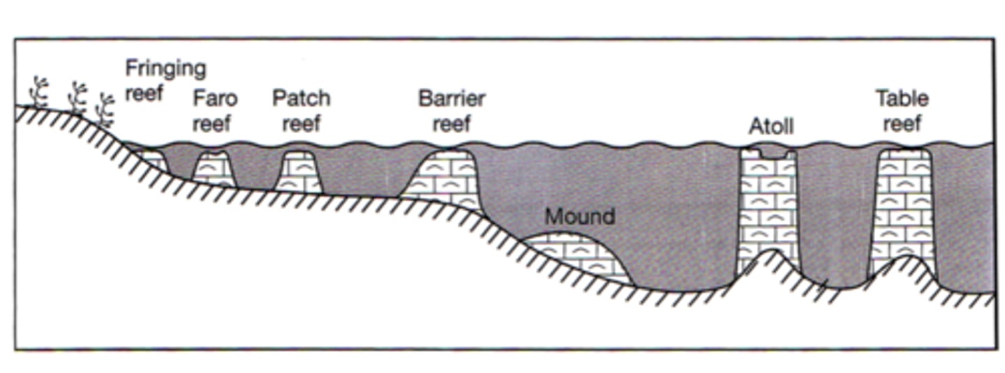
fringing coral reef
most common type of reef, grows directly from land and creates a border along the shoreline
Flat portion of reef extends out and then crests to drop off into the water
barrier coral reef
form parallel to land kind of like a barrier island; grow further out to sea and are separated from the shore by a lagoon
coral symbiosis relationship
Symbiotic relationship with zooxanthellae
- Dinoflagellate,
- Autotrophic - source of coral nutrients
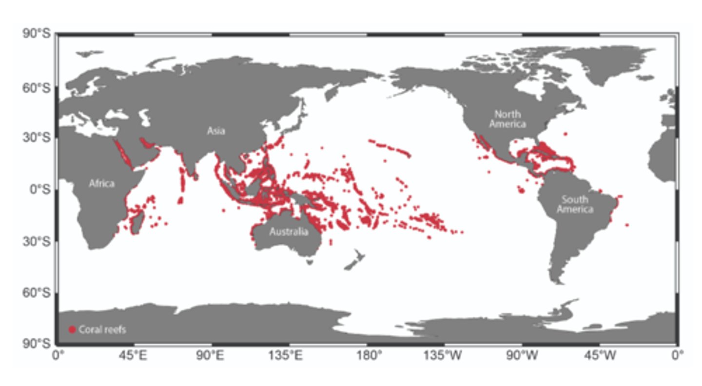
coral reef distribution
threat to coral reefs
Coral bleaching• - Corals expelling their symbiotic zooxanthellae
Rising ocean acidity
Rising oceantemperature
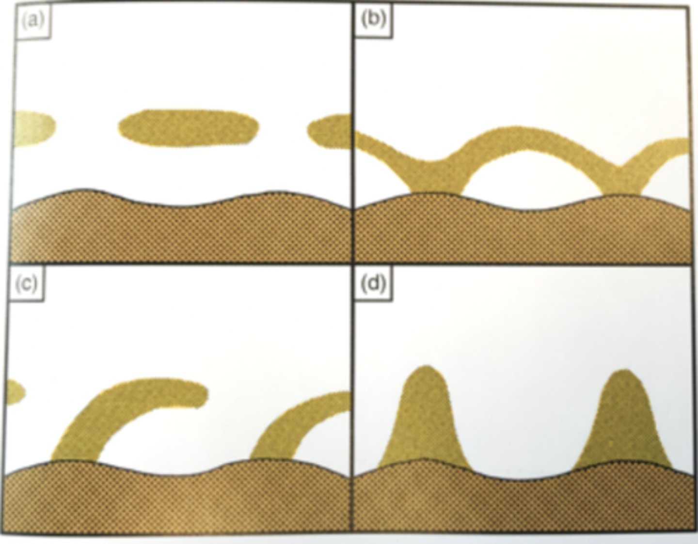
atoll formation process
over time, a volcano or seamount surrounded by a reef erodes or rising sea levels cause it to flood; leaves the form of an atoll with a lagoon in the center
carbonate factories
warm water carbonate factory:
- Shallow-marine tropical waters supporting rapidly calcifying communities of organisms that rely on photosynthesis for energy
- Waters supersaturated with calcium carbonate which maybe precipitated as ooid sand or lime mud.
- Coral Reefs with symbiotic algae
physical factors controlling carbonate formation
the ones that control CO2 concentration
Temp (higher temp means less CO2 means more carbonates in warm water)
Pressure (lower pressure means less CO2 means more carbonates in shallow water)
Degree of agitation (higher agitation means less CO2 means more carbonates in well-aerated water
Salinity (lower salinity means reduced concentration of foreign ions means more carbonates in less saline waters)
biological factors controlling carbonate formation
Direct extraction (bio-mediated precip as hard parts/skeletal material)
Photosynthesis (consumes CO2, more carbonates in high primary production areas)
Organic decay (produces CO2, less carbonates in areas of decay)
Feeding (reshapes and aggregates carbonates - pellets)
Bacterial activity (promotes precipitation)
ecosystem services from reefs
habitat
coastal protection from waves/storms
fisheries
water quality (particularly oyster and coral reefs)
sand bars
Sometimes there are multiple sand bars attached to a shoreline
Types
- Out from beach and cured to one side in direction of longshore transport
- Directly out from beach perpendicular
- Parallel to beach in small spurts
- Arch shapes against beach
classification of beaches
Along a continuum - reflective to dissipative
Reflective: steep beach, almost like a wall (most wave energy is reflected back off shore)
Dissipative: very gentle slope that extends a long distant (wave orbital hits gentle slope and breaks, wave energy is dissipated by ramp shape)