NR 220: Assessment Review
1/90
There's no tags or description
Looks like no tags are added yet.
Name | Mastery | Learn | Test | Matching | Spaced | Call with Kai | Chat |
|---|
No analytics yet
Send a link to your students to track their progress
91 Terms
Do you add or subtract for declination when going from true geographic direction to magnetic geographic direction?
Subtract
Do you add or subtract for declination when going from magnetic geographic direction to true geographic direction?
Add
What is the declination at the Mountain Campus?
8°
How did the U.S. Public Land Survey divide townships?
Baselines and meridians
How far apart are each baseline and each meridian from one another?
24 miles
Are errors in land survey common due to instrumentation?
Yes
What are some characteristics used to develop GPS datum?
All of the above
What does a brown X on a topographic map represent?
A peak
What act did the Public Land Survey System (PLSS) come from?
The Land Ordinance Act of 1787
What is an application of the GPS?
All of the above
One section in a township is how many square miles?
1
Which of the sources of error for a GPS could result from a dense forest canopy?
Blocked view error
What does UTM stand for?
Universal Transverse Mercator
Which azimuth is the principal point of southwest on a compass?
225°

Label 19 points at which part of the compass?
Magnetic needle

Label 20 points at which part of the compass?
Direction of travel arrow

Label 18 points at which part of the compass?
Orienting lines
One tenet of the North American Wildlife Management Model is that wildlife is owned by all citizens.
True
Which level of government has primary responsibility for enforcing the Endangered Species Act?
Federal
What type of law is the Migratory Bird Treaty Act?
Federal
Which species are you most likely to see in the alpine?
Ochotona princeps
Which of the following species is not part of the important symbiosis that takes place in lodgepole pine forests?
Thomomys talpoides
What are some interesting adaptations of woodpeckers?
All of the above
What species does pneumonia most affect?
Ovis canadensis canadensis
What is the state fish of Colorado?
Oncorhynchus clarkii stomias
Which animal leaves a sign of round holes bored in wood?
Cerambycidae
Which animal leaves a sign of a large midden of pinecone pieces at the base of a pine tree?
Tamiasciurus hudsonicus
What forest habitat is Abert’s squirrel an obligate of?
Ponderosa pine
What species does chytrid fungus most affect?
Anaxyrus boreas
What venomous snake are we most likely to find in Colorado?
Crotalus viridis
Which species is known for its underground lifestyle?
Thomomys talpoides
Which of these species are important berry-like producers that wildlife use for food?
All of the above
Which of these birds are aerial insectivores?
All of the above
Have grasses and forbs co-evolved with grazing?
Yes
What category of grazing management covers how often a plant is grazed?
Frequency
What is the difference between a pasture and a rangeland?
Rangelands are comprised of naturally growing species
Are all rangelands grazed?
Yes
What is the term for a hair-like projection attached to the back of the florets in some grasses?
Awn
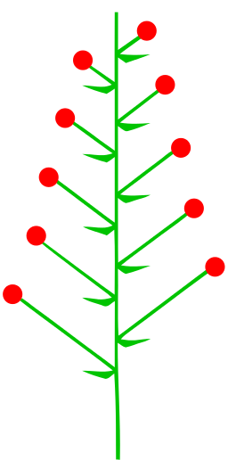
What type of inflorescence is shown here?
Raceme
What is the term for the flower of a grass plant?
Floret
What is the most basic unit of plant growth that makes up the plant?
Phytomer
What is an above-ground modified stem called?
Stolon
What is a below-ground modified stem called?
Rhizome
What is the state grass of Colorado?
Bouteloua gracilis
What is the perennial grass with a long ligule that grows in the understory of ponderosa pine forests?
Leucopoa kingii
Which grass has awns and a bulb at the base of the tiller?
Phleum pratense
What forest understory is Pyrola spp. most commonly found in?
Lodgepole pine
What factor plays the most important role in determining climate globally?
The tilt of the Earth
What does relative humidity equal when air temperature and dew point temperature are the same?
100%
What is the term for warm air rising over a mountain and causing cloud formation?
Orographic lifting
What are the most important environmental factors?
All of the above
What types of processes are erosion and deposition?
Physical
Which variable is often measured concurrently at an evaporation pan?
Wind speed
What does an anemometer measure?
Wind speed and direction
What measurements are needed to determine the site index?
Both
Will a higher basal area factor yield fewer ‘in’ trees?
Yes
Does a 14-inch tree have a greater chance of being counted as ‘in’ than a 17-inch tree?
No
If the distance from a sample point to a tree is less than the limiting distance, is that tree in or out?
In
What does the BIDE population model measure?
All of the above
Which method of collecting data is most likely to lead to a biased estimate?
Surveying along roads
Which is not an assumption of the 2-pass removal estimator?
The population is open
What percent of consumer spending in Colorado does outdoor recreation account for?
13%
Which of the following did the CCC complete?
Red Rocks Amphitheatre
According to the REP model, what are recreation experiences influenced by?
All of the above
Which group was responsible for creating many of the trails and campgrounds in our country?
The Civilian Conservation Corps
What term refers to the overall durability of vegetation or soil regarding recreation impact?
Tolerance
What is not a good campsite mitigation?
Creating a grade reversal at the tent pad
What term refers to a learned behavior due to human feeding?
Attraction
What term refers to the result of repeated human interaction with wildlife?
Habituation
What term refers to an escape response of wildlife due to interactions with humans?
Avoidance
What impact can sunscreen have on a high alpine lake?
Increased turbidity
What trail drainage design is suitable for a trail with a 4 percent grade?
Knick
What trail drainage design is suitable for a trail with a 10 percent grade?
Rolling grade dip
What is the most important factor for producing a sustainable trail?
Proper drainage
What is the best type of soil for trail building and mitigation?
Loam
What is not one of the three goals of trail design and planning?
Provide varying degrees of difficulty
Is the development of volcanic islands an example of secondary succession?
No
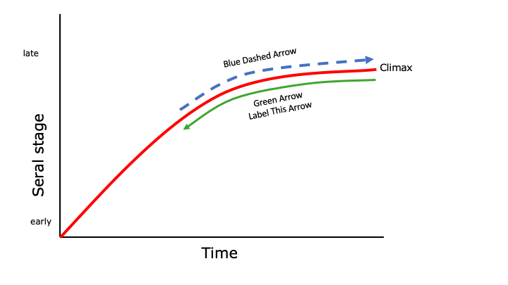
What is the best label for the green arrow?
Retrogression
How would a rangeland community with 51-75 percent of the species present in the climax community be classified?
Late seral
How would a rangeland community with 26-50 percent of the species present in the climax community be classified?
Mid seral
What is the highest apparent trend score that can be given on a rangeland?
20
What is the term for where a tributary joins a main river channel?
Confluence
What is the term for the beginning of a river?
Headwaters
What is the term for the imaginary line connecting the deepest parts of the river channel?
Thalweg
What term measures the maximum particle size a stream can carry?
Competence

What does C on the diagram represent?
Infiltration
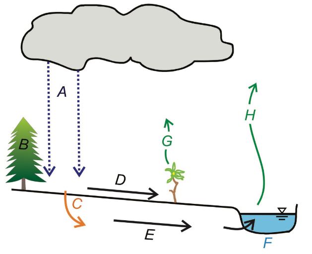
What does E on the diagram represent?
Groundwater

What does B on the diagram represent?
Interception

What does A on the diagram represent?
Precipitation
Why is a correction coefficient necessary when calculating streamflow using the float method?
Stream surface velocity is faster than the average velocity
What is the term for the difference in elevation between lines on a topographic map?
Contour interval