Geography GCSE revision
1/68
Earn XP
Description and Tags
Name | Mastery | Learn | Test | Matching | Spaced |
|---|
No study sessions yet.
69 Terms
Chemical weathering
caused by rainfall which creates a chemical reaction when hitting rocks
Freeze-thaw weathering
when water enters cracks in the rock and freezes, prizing open the rock over time, as water expands by 8% when frozen
Erosion
the process by which soil and rock are removed from the earth’s surface by wind, water, ice or biological activity
Weathering
the breaking down of rocks in situ (without moving)
Biological weathering
the breakdown of rocks by living organisms
Mechanical weathering
the physical breakdown of rocks into smaller pieces through extreme temperatures
Vertical erosion
when erosional energy is focused downwards (vertically) due to gravity
Lateral erosion
when erosion acts in a sideways motion
Transportation
when a river carries material downstream
Traction
large, heavy pebbles are rolled along the river bed, mainly near the source as the load is larger
Saltation
pebbles are bounced along the surface, mainly near the source
Suspension
lighter sediment is suspended within the water, mainly near the mouth
Solution
the transport of dissolved chemicals along the river
Deposition
when a river loses energy and drops its load
Formation of waterfalls
The river meets a band of more resistant rock, typically in the middle course
Erosion of the soft rock leads to an undercutting of the hard rock and creating a plunge pool
As the soft rock is eroded quicker, an overhang is created which causes the hanging hard rock to collapse and fall into the plunge pool
The waterfall is forced to retreat upstream over time as this process continues, leaving a steep valley or gorge
Formation of levees
During floods, water is slowed at the banks so silt is deposited on the side
In-between floods, the slow moving river deposits silt on the riverbed
The levees continue to build up as more floods take place and create a new river level
Material continues to build up on the riverbed, causing the river to go back to its original volume or possibly even less
Land use by humans
Agriculture - around 85% of South Downs National Park is farmed, due to chalk grassland being ideal for grazing sheep, clay for grazing cows, and lower slopes for arable farming
Forestry
Many forests have been felled or replaced with faster-growing, non-native trees to improve the demanding timber industry
Some regions have become more vegetated de to afforestation by humans
UK charities such as Woodland Trust protect and increase forests
Settlements
Building materials recently haven’t reflected traditional design
Downs suitable for spring line settlements built on south slopes, leading to 12,000 residents (most populated UK NP)
Mostly rural area but some major towns and cities surrounding SDNP, like Brighton and Southampton
Metamorphic rocks
Pre-existing rock whose shape or form has been changed by heat and/or pressure
They contain regularly aligned crystals and can b shiny and hard, and sometimes flake into layers
Contact metamorphism is when nearby igneous intrusions change characteristics in the rock
Regional metamorphism occurs during an orogenic event (mountain building).When large continental plates collide, they create hue compressional forces that change the rock’s characteristics
examples include slate and marble
Igneous rocks
Rock that began as magma in the interior of the Earth.
Formed when magma/lava cools and solidifies
2 types of igneous rock - extrusive and intrusive
Extrusive formed when magma erupts and lava cools quickly on the ground. They typically have small crystals.
Intrusive formed when magma is deep underground and intrudes into other rocks without reaching the surface, after which it cools slowly. They typically have larger crystals.
Igneous rocks are impermeable.
examples include granite and basalt
Sedimentary rocks
Rocks that began as sediment, usually on the seabed.
When eroded fragments of rocks and organisms settled to form a sediment. Over millions of years, layers built up and are buried on top of one another and compressed by their own weight which squeezes out the water.
They have a layered appearance called strata. May contain fossil remains of animals and plants that were trapped as the rock was formed and they can can be used to date the rock. They are usually permeable.
examples include chalk, sandstone and limestone
Batholiths and Tors
A batholith is an enormous mass of intrusive igneous rock made of once molten material that has solidified below the Earth’s surface. They are only exposed after lots of erosion of overlying mountain. Dartmoor batholith is made of granite.
A tor is a rock outcrop formed by weathering, and a result of magma at very high temperatures and deep underground being cooled very slowly a long time ago, causing crystal formation. It then solidified and got exposed when the soft rock above was eroded away.
An example of a famous tor is Haytor in Dartmoor - it is ~300 million years old.
Joints are create by shrinkage in the cooling granite and weakened by weathering widening them
Types of ice
Glacier: A finger of ice usually extending downhill from an ice cap and occupying a valley. Can also form in lower latitude areas when there is high altitude. When accumulation>ablation, glacier grows and extends. When ablation>accumulation, glacier shrinks and retreats
Ice sheet: A large body of ice >50,000km in extent
Ice cap: A smaller dome-shaped body of ice, <50,000km in extent, and usually found in mountainous areas.
Corrie formation
Snow collects in a depression on the mountainside.
Over time, more snow builds up and the extra weight compresses the snow, turning it into névé and then ice.
The hollow gets deepened and widened through abrasion and plucking. the glacier moves in a rotation due to the pressure and therefore deepens the hollow and creates a distinct armchair shape. The corrie lip also forms here as there is less erosion on this part as it is focused on the back wall
Erosion is the greatest at the back wall, near the bottom, and at the base of the hollow as the ice is thickest there.
The ice moves due to rotational slip causing loose rock fragments from erosion to embed in the ice and cause abrasion on the surface of the hollow.
Water seeps down the bergschrund crevasse, leading to freezing and freeze-thaw weathering on the back wall. The freeze-thaw of rocky outcrops create rocky fragments called scree.
At the front of the corrie, the ice is thinner so a raised lip is formed as there is less erosion here.
After glaciation when all the ice is melted, a tarn(also known as corrie lake) forms in the hollow due to meltwater.
Arete
An arete forms when two glaciers erode towards each other on opposite sides of the mountain, which carves out corries with steep back walls. As the glaciers continue eroding the corrie, the rock in between becomes narrower, steeper and sharper, forming a sharp ridge exaggerated by freeze-thaw.
Pyramidal peak
Forms when 3+ corries form on different sides of the same mountain, which have steep walls. As the glaciers erode towards the centre, the peak becomes pointed and further sharpened by freeze-thaw.
Erratic
stones and rocks of a foreign type to the area they have been deposited in and they were deposited during an ice age. Typically found in the U-shaped valley (glacial trough) in the ablation zone
U-shaped valley/glacial trough
Up to 500m wide and can be kms long
Was a v-shaped valley in pre-glacial times
During glaciation, glaciers form in the valley and use abrasion and plucking to deepen and widen the valley
The front end bulldozes soil and plucks rock from interlocking spurs to truncate them and create truncated spurs
Misfit stream
A small stream of water that occupies the glacial floor, a landscape created by the glacier, not the river
Hanging valley
When a smaller tributary glacier meet, the tributary erodes less deep than the main glacier as it had less mass and moraine, so the tributary glacier is left hanging high above the main valley and when rivers return, they often form waterfalls
Roche moutonnée
An outcrop of resistant bedrock with a gentle abraded slope on what would’ve been the upstream side of the ice (stoss slope) and a steep rougher slope on the downstream slope (lee slope)
Generally between 10-15m long but can be much larger
Striations found on the stoss side- parallel grooves indicating direction of ice flow
Smooth upstream slope caused by abrasion as the ice advances over the rock
Rough lee side due to plucking where ice has attached to the rock and pulled fragments away
Plucking occurred because as the ice has moved up the stoss slope, reduction in pressure which allowed liquid water to re-freeze and attach to underlying rocks
Drumlin
A piece of more resistant rock is found on the valley floor in the ablation zone
As the the glacier meet the moraine, it doesnt have enough energy to erode resistant moraine which leads to deposition of till
As glacier moves over the resistant moraine, it begins to smooth the material as it moves down the lee slope
Drumlins are blunt at one end, where resistant moraine is found, and tapered at the other
Tapered end points in direction of ice flow
Up to 50m tall, 800m long
Crag and Tail
A rock hill (crag) with a tapering ridge on its lee side (tail)
Range in size from several metres to kms in length
Tail points in direction of ice flow
Edinburgh castle is an example
Formed by erosion and deposition
When glacier meets more resistant bedrock, ice is forced to flow over and around
Plucking and abrasion on upstream side steepen the slope and make it jagged, forming crag
At the crag, velocity and pressure of ice decreases
If there’s a hollow in the softer rock behind the crag, deposition occurs and decreases with distance from the crag creating the tail
Types of moraine
Lateral: found at sides of glacier, formed from frost-shattered rock that falls onto glacier
Ground: material carried in the base of the glacier, as it moves, it melts and leaves a trail of till, forming an uneven hummocky floor
Terminal: found at the furthest extent of glacial advance
Recessional: found at the glacier snout
Medial: found in the centre and is from the meeting of 2 lateral moraines where 2 glaciers join
Factors affecting temperature worldwide: Latitude and angle of incidence
Angle of incidence is the angle at which suns rays strike earths surface
At equator, angle is ~90° so heat is concentrated and covers smaller area, so temperatures are high
At higher latitudes, angle is larger so heat covers larger area and is less concentrated, leading to colder temperatures
Further from equator=higher angle of incidence=colder
Winter darkness
Earth revolves on a tilt
During winter poles are tilted away so these areas don’t get sunlight
Poles have nearly 5 months of summer light and 5 of winter darkness which makes them very cold
Altitude
For every 1km upwards, air temp decreases by 6.4°C due to factors such as air pressure and water vapour
When warm air rises it expands which requires energy drawn from heat from air air around it
As it expands with increasing altitude, rising air becomes cooler
Higher areas are much colder than lower areas
Albedo effect
Defined as ability of a surface to reflect sunlight
Light coloured surfaces (high albedo) reflect more sunlight than dark coloured surfaces (low albedo)
ice or snow-covered areas have high albedo like the Arctic
At the poles up to 90% of sunlight is reflected which keeps the area very cold
Continental effect
Oceans take longer to heat up and cool down than land masses, leading to milder temperatures in coastal areas
Inland areas have warmer summers and colder winters
Prevailing winds, aspect and ocean currents
Temperature of prevailing winds depend on where they originate from, winds blowing over seas tend to be warmer in winter and cooler in summer
Hillsides alter angle of incidence for the ground - south facing slopes are warmer than north facing
Ocean currents regulate heat around the world, warm currents go towards the poles and cold currents go towards the equator
Relief rainfall
Wet air rises over an ocean over a mountain
The higher air cools and condenses causing cloud formation and precipitation
Air goes back down the mountain and warms
Evaporation means no or little clouds, meaning this area is dry
Frontal rainfall
Mostly occurs in mid-latitude regions where warm tropical air meets cold polar air
Jet stream from W=>E, when warm air meets cold air, the arm, less dense air is lifted over the dense cold air
As a result, rain is produced from warm air condensing
Convectional rainfall
Produced by buoyant air rising in clouds as a result of warm air rising due to evaporation from sunlight, called low pressure air
As air gets higher, water vapour condenses as it is colder, forming cumulonimbus storm clouds
3 cell model
Equator - low pressure, Hadley cell
wet and cloudy, windy as wind gets sucked from high to low pressure areas, warm due to latitude
Wet sue to low pressure air rising and cooling, so water vapour condenses and forms clouds and causes rain
30°N/S - Ferrell+Hadley cells
Dry, extreme temperatures, very hot or cold
High pressure air sinks causing water vapour to evaporate which means clouds cannot form, causing dry weather
60°N/S - Ferrell+Polar cells
Wet and cloudy, windy as wind gets sucked from high to low pressure areas, milder weather due to latitude
90°N/S - Polar cell
Dry, cold due to latitude
High pressure air sinks causing water vapour to evaporate as temperature increases causing dry weather
Factors affecting UK climate: Latitude and relation to cells
Between 50-60°N of equator
Near boundary of Ferrell and Polar cells
Warm air from S and cool air from N meet leading o depressions and unsettled weather
Distance from equator affects climate as it receives less solar radiation than areas near equator, temperate climate with very rare extreme weather events
Frontal rainfall is common
Ocean currents for UK
Warm ocean current called North Atlantic drift brings warm water from Gulf of Mexico to N driven by prevailing winds
Warm water makes UK climate milder than expected for latitude
Prevailing wind for UK
Prevailing wind is SW
Travelled over large expanses of warm ocean so air is warm and wet
PW reaches western areas of UK first and releases moisture as rain there
Therefore east is relatively dry
Regional variations in UK climate
NW - Cool summers eg. 10°C, mild winters eg. 5-6°C, heaviest rainfall eg. 2800-4700mm average/year
NE - Cool summers eg. 12-13°C, cold winters eg. -1-0°C, dry eg. 800-1300mm average/year
SW - Warm summers eg. 14-16°C, mild winters eg. 5-6°C, heavy rainfall eg. 1700-2800mm/year
SE - Warmer summer eg. 16°C+, colder winters eg. 3-5°C, driest eg. 400-800mm rainfall/year
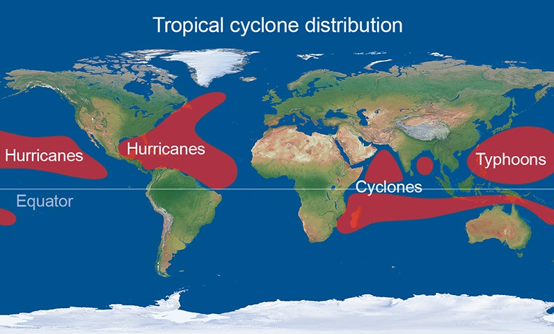
Tropical storms
Formed 5-30°N/S of equator due to Coriolis effect being negligible on equator or too weak near it
Warm ocean, 27+°C as this is where the storm gets energy from
Depth of water must be ~60-70m
Occurs when warm air rises to create an are of intense low pressure
As warm, moist air rises, powerful winds spiral around calm eye and warm air condenses into heavy rainfall and thunderstorms
When it goes over land a large amount of water is thrown onto the land called storm surge
Due to lack of energy source through deep warm water
Storm collapses and dissipates
Wind speeds must be >74mph to be hurricane/cyclone/typhoon
Chemical weathering
caused by rainfall which creates a chemical reaction when hitting rocks
Freeze-thaw weathering
when water enters cracks in the rock and freezes, prizing open the rock over time, as water expands by 8% when frozen
Erosion
the process by which soil and rock are removed from the earth’s surface by wind, water, ice or biological activity
Weathering
the breaking down of rocks in situ (without moving)
Biological weathering
the breakdown of rocks by living organisms
Mechanical weathering
the physical breakdown of rocks into smaller pieces through extreme temperatures
Vertical erosion
when erosional energy is focused downwards (vertically) due to gravity
Lateral erosion
when erosion acts in a sideways motion
Transportation
when a river carries material downstream
Traction
large, heavy pebbles are rolled along the river bed, mainly near the source as the load is larger
Saltation
pebbles are bounced along the surface, mainly near the source
Suspension
lighter sediment is suspended within the water, mainly near the mouth
Solution
the transport of dissolved chemicals along the river
Deposition
when a river loses energy and drops its load
Formation of waterfalls
The river meets a band of more resistant rock, typically in the middle course
Erosion of the soft rock leads to an undercutting of the hard rock an creating a plunge pool
As the soft rock is eroded quicker, an overhang is created which causes the hanging hard rock to collapse and fall into the plunge pool
The waterfall is forced to retreat upstream over time as this process continues, leaving a steep valley or gorge
Formation of levees
During floods, water is slowed at the banks so silt is deposited on the side
In-between floods, the slow moving river deposits silt on the riverbed
The levees continue to build up as more floods take place and create a new river level
Material continues to build up on the riverbed, causing the river to go back to its original volume or possible even less
Factors affecting biome distribution - Climate
Affects plant growth
Plants need temperatures >5°C to grow
Water is essential, they grow best when there is annual supply
Sunshine hours and intensity affect RoP
Factors affecting biome distribution - Latitude
Higher latitude = more obtuse angle sunlight hits Earth’s surface, more energy is dispersed
Rays are less concentrated and have to cover a larger area
Lower latitude = less energy is dispersed
Rays are more concentrated and intense and have to cover a smaller area
This means lower latitude areas are usually hotter
Factors affecting biome distribution - Altitude
Trees and plants cant grow at very high altitudes as temperature decreases with increase in elevation
More relief rainfall could cause clouds which block sunlight and stunt plant growth
Factors affecting biome distribution - Rock/soil type
Weathering can add nutrients to the soil which can lead to heavily