Ap classrooms
1/28
There's no tags or description
Looks like no tags are added yet.
Name | Mastery | Learn | Test | Matching | Spaced | Call with Kai |
|---|
No analytics yet
Send a link to your students to track their progress
29 Terms
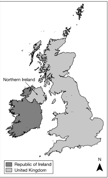
Analyze map of Northern Ireland
A. It is united with the rest of the island to form a sovereign nation-state.
B. It forms its own sovereign nation-state predominately made up of the Irish ethnic group.
C. It is a frontier that is not formally part of a state, but the United Kingdom claims the area.
D. It is physically separate from the rest of the United Kingdom, a multinational state.
E. It is a stateless nation, as the entire island of Ireland is under the control of the United Kingdom.
D. It is physically separate from the rest of the United Kingdom, a multinational state.
Northern Ireland is physically separated from the island of Great Britain containing England, Scotland, and Wales, but it is connected by land to the Republic of Ireland. All form distinct nations that have been given some degree of autonomy and self-rule but are still united under the United Kingdom.
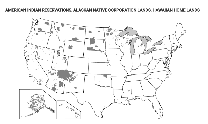
Which of the following terms identifies the type of regions shown in the dark gray-shaded areas on the map?
A. Functional regions
B. Urban regions
C. Physical regions
D. Vernacular regions
E. Semiautonomous regions
E. Semiautonomous regions
The map shows American Indian reservations, Alaskan native corporation lands, and Hawaiian home lands, which are semiautonomous regions under the sovereignty of the United States federal government.
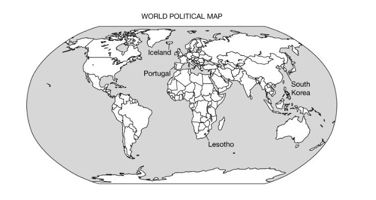
Owing to their localized geography or their locations on islands or peninsulas, many small political entities such as those labeled on the political map of the world can be identified as…
A. Federal states
B. Autonomous republics
C. Multistate nations
D. Nation-states
E. Colonial territories
D. Nation States
Nation-states are countries with a single government and a singular ethnic culture. Nation-states tend to be small in size or are located in remote locations such as peninsulas or islands.
Some territories within the Russian Federation are characterized by concentrated populations of ethnic groups and these areas function as autonomous republics. Which of the following best explains the political relationship between the autonomous republics and the central government of Russia?
A. The central government of Russia exerts complete control over the autonomous republics to counteract devolutionary pressures.
B. The autonomous republics are able to function independently from the central government because of an abundance of natural resources.
C. Russia is a multistate nation characterized by contested regional boundaries.
D. The autonomous republics provide ethnic groups with some political control over their homelands while preserving Russia’s territorial integrity.
E. Russia is a unitary state characterized by many ethnic groups united within a single country.
D. The autonomous republics provide ethnic groups with some political control over their homelands while preserving Russia’s territorial integrity.
Each autonomous republic maintains a significant amount of independence but shares some power with Russia’s central government. This political system preserves ethnic groups’ connection to and control over historic ethnic homelands while maintaining the central government’s territory.
Which of the following best explains the effect of French language and culture on the federal state of Canada’s political power?
A. French language and culture act as a centripetal force throughout Canada as the majority of Canadians have English as a first language and the government uses both languages in official communications.
B. As an expression of political power, the Canadian federal government restricts French language and culture from media and government proceedings.
C. French language and culture act as centripetal forces and unify all of Canada’s people and government into a single nation.
D. French language and culture act as a centrifugal force in Canada because independence movements in Quebec have attempted to secede the province from Canada.
E. Because French Canadians are spread across the country’s provinces, the Canadian government implemented federal laws to create a common culture and language for all Canadians.
D. French language and culture act as a centrifugal force in Canada because independence movements in Quebec have attempted to secede the province from Canada.
The distinctiveness of the Quebecois people (the ethnic French in Quebec) has acted as a centrifugal force because of political movements that advocate for Quebec’s independence from Canada.
Which of the following explains why Korea and Vietnam were viewed as shatterbelts during the Cold War?
A. Korea and Vietnam were politically controlled by regional powers.
B. Korea and Vietnam kept two political adversaries geographically separated.
C. Korea and Vietnam fragmented into new states due to internal tensions.
D. Korea and Vietnam tried to control land and sea areas around their states.
E. Korea and Vietnam experienced conflict due to a dispute between global powers.
E. Korea and Vietnam experienced conflict due to a dispute between global powers.
Korea and Vietnam were shatterbelts, as they were areas thrown into conflict due to internal tensions and were caught in the middle of a dispute between the United States and the Soviet Union during the Cold War.
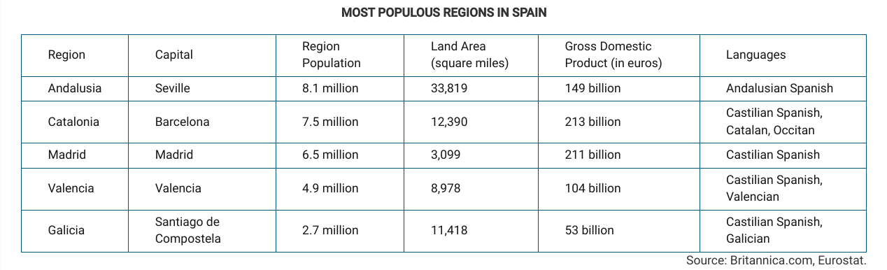
Which of the following best explains why the region of Catalonia in Spain could be a viable country?
A. Catalonia is linguistically distinct compared to other regions in Spain.
B. Catalonia is well developed economically compared to other regions in Spain.
C. Catalonia's population is ethnically distinct compared to other regions in Spain.
D. Catalonia has a large population compared to other regions in Spain.
E. Catalonia has a major city, Barcelona, which has a notoriety comparable to that of the Spanish capital, Madrid.
B. Catalonia is well developed economically compared to other regions in Spain.
The Catalan region accounts for approximately one-fifth of Spain’s economy and is an important industrial and banking center. These economic resources give viability to the idea of an independent Catalonia.
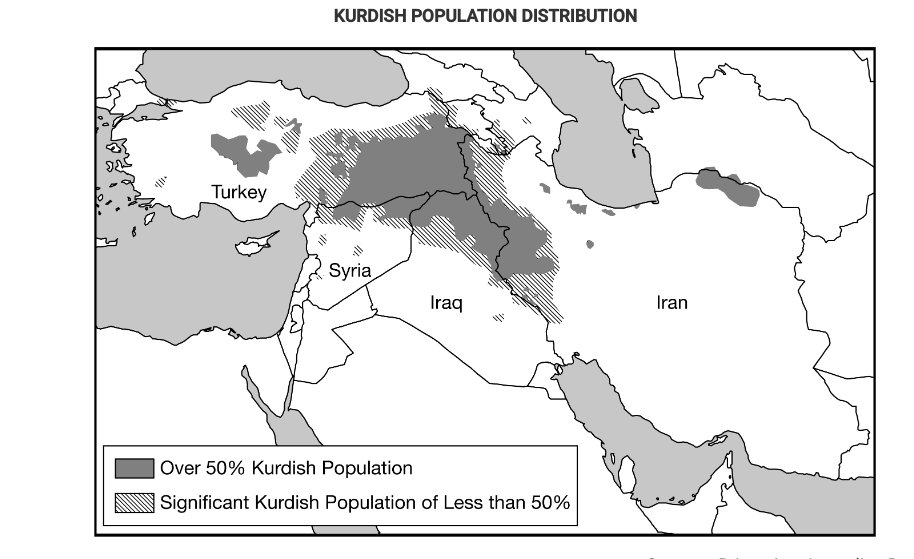
Based on the information in the map, what is the most likely outcome of the possible establishment of an independent Kurdistan for the Kurdish people?
A.The state of Turkey, seeking to connect areas with a substantial Kurdish population into an independent state, might take action against neighboring states.
B. The Kurdish people, seeking a state of their own with a majority Kurdish population, might secede from or rebel against the states labeled on the map.
C. The Kurdish people would have to migrate into a single country to gain a population majority and would struggle for control of the government.
D. In areas with a Kurdish majority population, Kurdish people are politically active among Turks, Iranians, Iraqis, and Syrians and would be able to win an election on a national vote to secede.
E. The countries shown on the map will cooperate and work together to address the political situation and needs of people in areas with a substantial Kurdish population.
B. The Kurdish people, seeking a state of their own with a majority Kurdish population, might secede from or rebel against the states labeled on the map.
The Kurds are a stateless nation and want to create a country out of the land shown on the map. The establishment of Kurdistan would require other states to relinquish some of their territory.
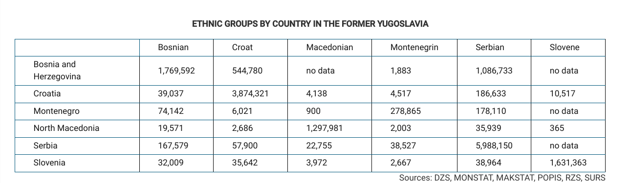
Which of the following best explains the political pattern shown in the table?
A. The devolution of Yugoslavia occurred primarily along national lines, resulting in countries with a defined ethnic majority.
B. The breakup of Yugoslavia was the result of a civil war in which ethnic groups fought for control of the capital of Belgrade in Serbia.
C. The Balkanization of Yugoslavia resulted in the formation of new ethnic nationalities divided by differences in religion and language.
D. The dissolution of Yugoslavia resulted in some ethnic groups being aligned with capitalist Western Europe and others being aligned with communist Eastern Europe.
E. The downfall of Yugoslavia was a case of ethnic differences becoming a centripetal force in the formation of a multistate nation.
A. The devolution of Yugoslavia occurred primarily along national lines, resulting in countries with a defined ethnic majority.
The data show that the countries were divided mainly by ethnicity, such that one ethnic group was in the majority of the resulting populations.
The Berlin Conference established the borders of North African countries including Egypt, Libya, and Sudan. The landscape of these countries influenced the types of boundaries imposed by the European colonial powers. Which of the following boundary types best explains the influence of landscape on the political borders of the North African region?
A. Antecedent, based on tribal cultural boundaries that existed before European colonization
B. Subsequent, with smaller buffer states placed between larger states to prevent political conflicts
C. Consequent, accounting for local differences in language and religion during European colonization
D. Natural, with irregular lines, accounting for regional physical features such as mountains or water bodies
E. Geometric, with straight lines, disregarding physical features or tribal cultural differences of the areas
E. Geometric, with straight lines, disregarding physical features or tribal cultural differences of the areas
Geometric or straight-line boundaries were created for Egypt, Libya, and Sudan without regard to natural landmarks and cultural features for ease of boundary demarcation and mapping in arid or desert regions with shifting sands.
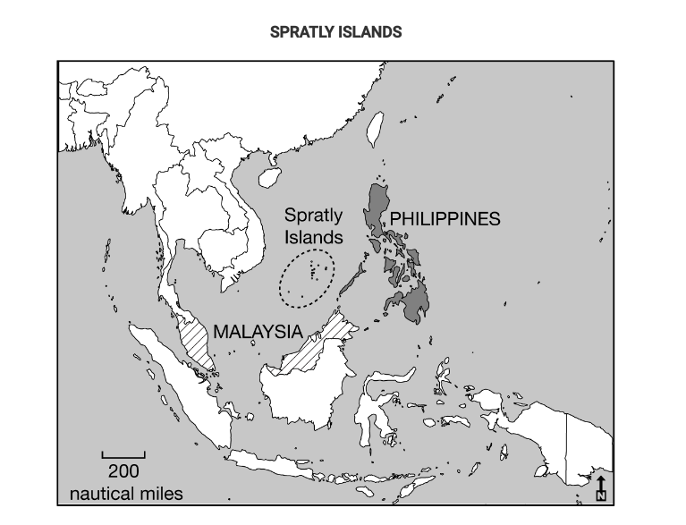
The Philippines and Malaysia lay claim to resources under and around the Spratly Islands. Which of the following best explains how the United Nations Convention on the Law of the Sea (UNCLOS) influences claims to the islands by both countries?
A. The claims to the Spratly Islands by both the Philippines and Malaysia overlap due to exclusive economic zones up to 200 nautical miles from their coasts.
B. The Philippines and Malaysia both claim the islands lie within their territorial seas up to 12 nautical miles from their coasts.
C. The claims to the islands by the Philippines and Malaysia overlap due to the median line principle.
D. The Philippines and Malaysia both claim ownership to the resources based on a historic possession of the islands.
E. The Philippines and Malaysia both claim the islands lie within their contiguous zones between 12 and 24 nautical miles from their coasts.
A. The claims to the Spratly Islands by both the Philippines and Malaysia overlap due to exclusive economic zones up to 200 nautical miles from their coasts.
Under UNCLOS, states gain resources 200 nautical miles from the coast and so controlling these islands would expand each state’s resources.
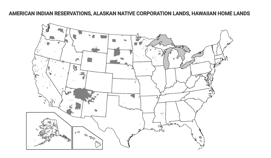
Which of the following best explains the governance of the shaded areas shown on the map?
A. These areas are established as nation-states for indigenous peoples at the local scale.
B. These areas show territory occupied by indigenous peoples as stateless nations at a local scale.
C. These areas show territory controlled by indigenous peoples as a single multistate nation.
D. These areas show where indigenous peoples have a limited amount of self-government at a national scale.
E. These areas are lands of indigenous peoples that are sovereign independent states at an international scale.
D. These areas show where indigenous peoples have a limited amount of self-government at a national scale
The lands shown on the map are areas where indigenous groups have limited self-government as semiautonomous regions. Tribal organizations exist as political entities at the national scale within the United States.
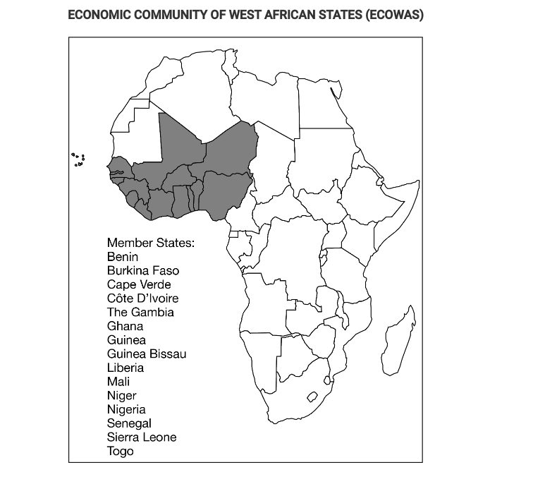
Which of the following is the correct organizational scale for the Economic Community of West African States (ECOWAS)?
A. Global
B. Supranational
C. National
D. State
E. Local
B. Supranational
The Economic Community of West African States (ECOWAS) acts as a supranational trade organization. ECOWAS countries share a free-trade zone where no tariffs are charged on goods crossing borders between member states.
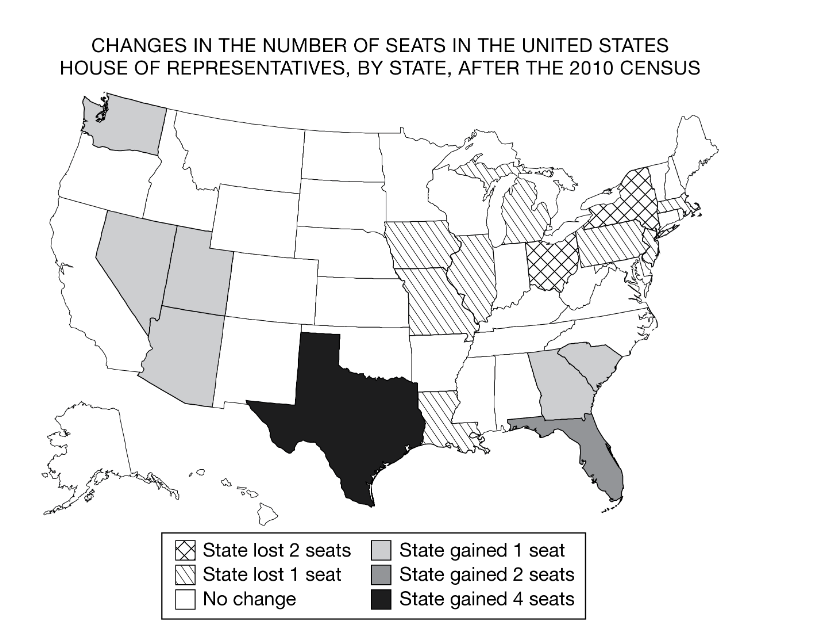
In the United States House of Representatives there are a fixed number of 435 seats divided among the states based upon each state’s relative population size. Changes in the number of representatives, as shown on the map, affect politics at which of the following scales?
A. City
B. County
C. State
D. Regional
E. National
E. National
Changes in the number of representatives per state impact politics at the national scale. States with more representatives have more influence in the federal government.
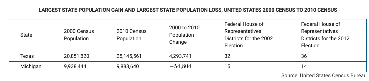
The examples in the table show states that gained or lost United States House of Representatives districts based on 2010 census data. The states were required to revise district boundaries based on census data.
Using the data in the table and the description, which of the following identifies the scales of analysis that are reflected in this redistricting?
A. Member state representation in a supranational legislature
B. Local representation in the state legislature
C. State representation in the regional legislature
D, Local representation in the national legislature
E. Local representation in the regional legislature
D. Local representation in the national legislature
The redistricting that occurs after each decennial census in the United States determines the number of House of Representatives districts per state in the national Congress.
Which of the following is an accurate comparison of devolutionary movements in Spain and Canada?
A. There is an economic aspect to the Quebecois independence movement, while the Catalans focus mainly on culture.
B. Both independence movements utilize cultural distinctiveness as their only reason for seeking independence.
C. Both independence movements focus on religious differences with the nations they currently belong to.
D. There is an economic aspect to the Catalan independence movement, while the Quebecois focus mainly on cultural differences.
E. Both independence movements utilize economic power as their main reason for seeking independence.
D. There is an economic aspect to the Catalan independence movement, while the Quebecois focus mainly on cultural differences
Both groups see themselves as being culturally distinct compared to the rest of Spain and Canada, but the movement for autonomy in the Catalan region also focuses on their economic strength, whereas the Quebecois mainly focus on ethnic and linguistic distinction.
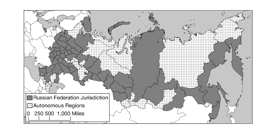
Compare the centralized power of the Soviet Union with the contemporary Russian Federation, in terms of the control of territory. Which of the following statements does the information in the map best support?
A. Russia is a global power with concentrated power in East Asia.
B. Russia is a multistate nation made up of numerous sovereign independent entities.
C. Russia’s autonomous regions illustrate a strategy to counter the difficulty in governing such a large area from a single centralized location.
D. Russia is an ethnically diverse region with many subnational units.
E. Russia used to control fifteen additional republics that regained their independence in 1990.
D. Russia is an ethnically diverse region with many subnational units.
The map suggests that Russia is made up of many subnational units. The granting of autonomous republics after the breakup of the Soviet Union acknowledged the cultural diversity of the region.
Which of the following events could be a threat to a state’s sovereignty at the national scale, while holding a region together at the global scale?
A. A natural disaster such as an earthquake or tsunami occurring within the country
B. A member of the state’s minority political party being elected to lead the country
C. Admittance into a supranational organization such as the European Union
D. Decommitment to environmental resolutions established by the United Nations
E. A shift from a federal system to a unitary system of governance within the state
C. Admittance into a supranational organization such as the European Union
Entrance into any supranational organization is a threat to sovereignty because political and economic decisions are made at the committee level instead of the state level, but it would bind together the countries within the supranational organization at a global scale.
The former international border between East Germany and West Germany is best described as
A. an open border
B. a demilitarized zone
C. a relic boundary
D. an antecedent boundary
E. geometric boundary
C. a relic boundary
A relict boundary is a political boundary that no longer exists. Germany was divided between Europe and Soviet Russia at the close of the Second World War, and in 1961 a physical barrier was constructed by the Soviets. The barrier was officially removed in 1989 and Germany was reunified in 1990.
Which of the following correctly compares the impact of centripetal forces at the local scale with the impact of centripetal forces at the national scale?
A. Centripetal forces may cause uneven development at the local scale but not at the national scale
B. Centripetal forces at both the local scale and the national scale may lead to increased cultural cohesion.
C. Centripetal forces may lead to stateless nations at the national scale but not the local scale.
D. Centripetal forces may result in nationalism at the local scale but not at the national scale.
E. Centripetal forces at both the local scale and the national scale may lead to failed states.
B. Centripetal forces at both the local scale and the national scale may lead to increased cultural cohesion.
Centripetal forces, such as a common ethnicity, religion, or a charismatic leader, help to unify populations and may lead to increased cultural cohesion at both local and national scales.
Which of the following describes typical characteristics of federal states?
A. A centralized government and strong centripetal forces
B. A fragmented land area and a single ethnic group
C. A small land area and high population density
D. A compact shape and a primate city
E. A large land area and multiple ethnic groups
E. A large land area and multiple ethnic groups
In a federal state, governance is organized into units such as regions, states, or provinces. Federal states are generally characterized by a large land area and multiple ethnicities.
Which of the following describes a federal form of governance?
A. A centralized government creates a barrier to local participation in the political process.
B. Autonomous regions act outside the authority of a central government.
C. Federal states encourage devolutionary movements and break apart quickly.
D. Laws are enacted in a single language to promote cultural unity.
E.. Multiple substates have local control and are unified to pursue common goals at the national level.
E. Multiple substates have local control and are unified to pursue common goals at the national level.
Federal states have dispersed power centers that give more power to the local level, keeping more of the population engaged in the political process.
Which of the following describes a unitary form of governance?
A. Stronger states and transnational corporations indirectly control weaker states.
B. A state has a strong central government with no power given to regions.
C. A collection of independent communities shares government services.
D. A state’s more powerful central government shares power with its regions.
E. A sense of unity, often derived from ethnic or cultural traits, binds a country together.
B. A state has a strong central government with no power given to regions.
Unitary governments are a form of governance in which there is a strong center of power exercising control over an entire state.
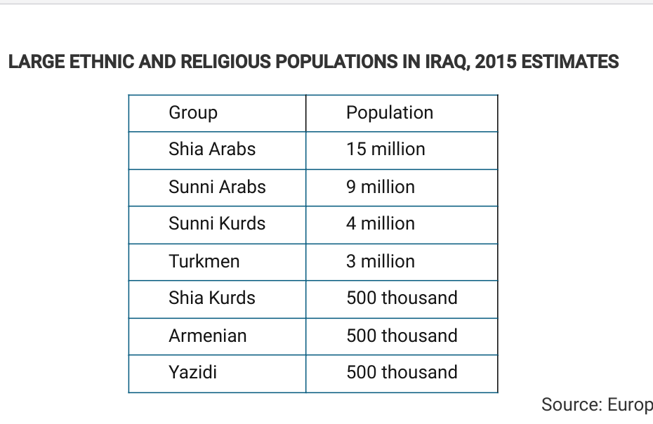
Based on the data in the table, which of the following is a possible impact of ethnic and religious diversity in Iraq?
A. Ethnicity and religion act as centripetal forces in the country by creating a common Iraqi identity among the population.
B. Ethnicity and religion facilitate democratization in the country by motivating participation in elections.
C. Ethnicity and religion promote economic development in the country by generating national pride in the country’s accomplishments.
D. Ethnicity and religion lead to devolutionary pressures in the country by politically dividing regions.
E. Ethnicity and religion increase cultural cohesion in the country by promoting shared political ideology.
D. Ethnicity and religion lead to devolutionary pressures in the country by politically dividing regions.
The ethnic and religious diversity increases devolutionary pressures on the Iraqi state, as the groups shown are at odds politically, and each contends for control over land and resources.
Which of the following describes an example of a consequent boundary?
A. The Berlin Wall between East and West Germany no longer exists, but the location is still evident.
B. European powers divided Africa at the Berlin Conference and drew boundaries across the continent.
C. The United States–Canadian boundary was set at the 49th parallel by a treaty before the area was settled.
D. Canada created the province of Nunavut to provide greater autonomy for the First Nations.
E. The Andes Mountains are used as a political boundary to divide Chile and Argentina.
D. Canada created the province of Nunavut to provide greater autonomy for the First Nations.
The province of Nunavut is a consequent boundary because it was drawn to accommodate the existing cultural landscape.
Which of the following compares the impact of increased global communications technology to the impact of state-controlled media?
A. Both global communication technology and state-controlled media act as centripetal forces that present a common message, which is utilized by the government to bind citizens together.
B. Neither global communications technology nor state-controlled media have any impact on the viability of a state when it comes to centripetal or centrifugal forces.
C. Global communications technology is utilized as a centripetal force to present a common message, whereas state-controlled media may bring in new ideas that act as centrifugal forces.
D. Both global communications technology and state-controlled media act as centrifugal forces because they give citizens access to concepts or ideas that may inspire dissent.
E. Global communications technology may bring in new ideas that act as centrifugal forces, whereas state-controlled media is utilized as a centripetal force to present a common message.
E. Global communications technology may bring in new ideas that act as centrifugal forces, whereas state-controlled media is utilized as a centripetal force to present a common message.
Global communications technology may give citizens access to new ideas, such as democracy or gender equality, that could inspire dissent, whereas state-controlled media is utilized to control the message and points of view to which citizens have access so that the country remains unified.
Nunavut in Canada is a semiautonomous region that allows an indigenous group within Canada to maintain their own culture and local government, reducing the threat of fragmentation. Which of the following best compares the impact of the creation of Nunavut at both local and national scales?
A. It created centrifugal forces at both local and national scales.
B. It created centrifugal forces at the local scale but not the national scale.
C. It created centrifugal forces locally and centripetal forces nationally.
D. It created centripetal forces at the national scale but not the local scale.
E. It created centripetal forces at both local and national scales.
E. It created centripetal forces at both local and national scales.
Canada allowing the Inuit population in Nunavut to maintain their culture and form their own local government continues to bind them together while also creating stronger bonds between the national and local levels, which helps prevent fragmentation.
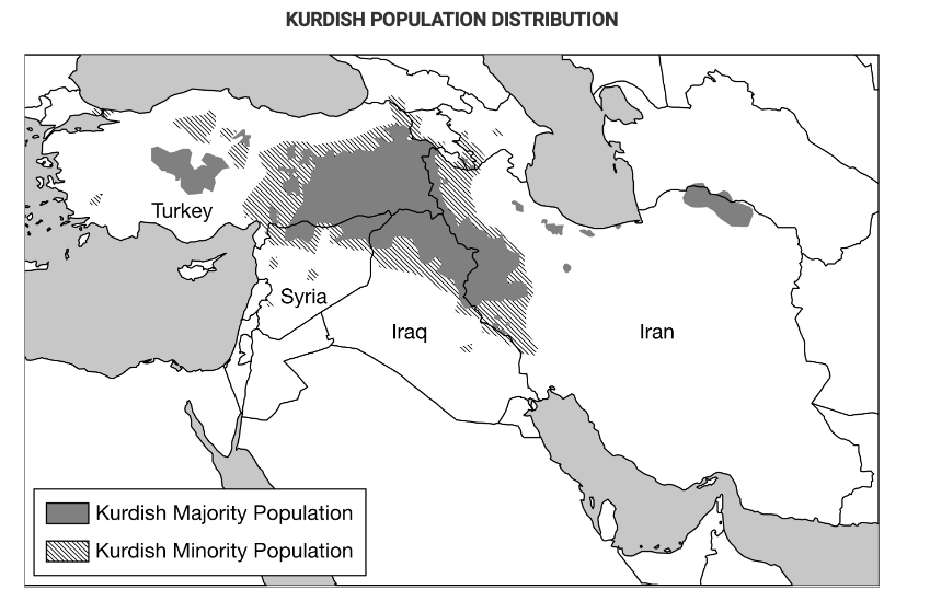
Based on the map, which of the following best explains the implications of physical geography as the Kurds continue to struggle for an independent state in their ethnic homeland?
A. Israel, Turkey, and Russia have voiced their support for an independent Kurdistan in areas with a majority Kurdish population, showing potential validation for Kurdistan.
B. In September 2017 a public referendum was carried out that demonstrated that a majority of Kurds overwhelmingly support independence.
C. Most areas with a Kurdish majority population are landlocked and therefore dependent on good relationships with their neighbors in order to access trade and prosper economically.
D. Even in areas with a Kurdish minority population, Kurdish people have their own unique culture and identity separately from the states in which their nation is located.
E. Unstable oil prices have created economic problems both in parts of the region with a Kurdish majority population and in parts with a Kurdish minority, leaving the Kurdistan Regional Government weakened and struggling to pay off debt.
C. Most areas with a Kurdish majority population are landlocked and therefore dependent on good relationships with their neighbors in order to access trade and prosper economically.
The physical geography of a potentially independent Kurdistan is problematic as the lack of ports and proximity to transportation hubs is a relative disadvantage for an independent state.
Which of the following is an example of a superimposed boundary?
A. The geometric boundary between the United States and Canada
B. The border of the European Union
C. The Pyrenees Mountains between France and Spain
D. The geometric boundary between Iraq and Saudi Arabia
E.The Great Wall of China
D. The geometric boundary between Iraq and Saudi Arabia
The boundary between Iraq and Saudi Arabia is an example of a straight-line boundary superimposed between the two states by an outside power.