6) landscapes and landforms
1/17
There's no tags or description
Looks like no tags are added yet.
Name | Mastery | Learn | Test | Matching | Spaced | Call with Kai |
|---|
No analytics yet
Send a link to your students to track their progress
18 Terms
landscape
= the picture, the visible features of an area
1. Natural elements of landforms
...mountains, valleys, coastlines and water bodies (rivers, seas, lakes)
2. living elements of land cover
... vegetation, wildlife
3. human elements
... different forms of land use (buildings, structures)
4. changeable elements
... weather conditions
landform
= the specific natural features
(morphology) of the land surface that results from the interaction of physical processes
e.g., the action of water (fluvial action). wind action, glacial action and weathering, tectonic movement
cliff coastline
= resistant rock, abrupt transition from land to sea where erosional processes and landforms dominate
sandy coastline
= less resistant rock, usually with a bay that has low lying land behind it
... depositional and transportation processes dominate
- sand dune ecosystems often formed
estuarine coast
= very gradual transition from the land to the sea, usually with high areas of flooding during high tide
... salt marsh habitats in temperate climates
... mangrove swamps in tropical zones
depositional processes dominate
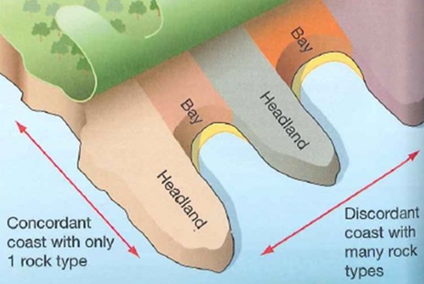
discordant coastlines
Made up of alternating bands of hard and soft rock at right angles to the coast

concordant coastlines
where the rock is parallel to the coastline
formation processes
Any processes natural or cultural that affects the archaeological record after its deposition
primary coasts = dominated by land based processes like deposition at the coast by rivers and coastal land
secondary coasts = dominated by marine erosion or depositional processes
relative sea level change
The change of sea level as it relates to a more local continental landscape
emergent coasts = where coasts are rising relative to sea level e.g., due to tectonic uplift
submerging coasts = are being flooded by the sea, either due to rising sea levels and/or subsiding land
tidal range
The difference in levels of ocean water at high tide and low tide
= varies hugely on coastlines, meaning coasts can be:
- micro tidal coasts (smallest tidal range
- mesotidal coasts (tidal range = 2-4m)
- macro tidal coasts (largest tidal range of over 4m)
wave energy
The transport of energy by ocean surface waves, and the capture of that energy to do useful work
low energy sheltered coast sixth limited fetch and low wind speeds result in small waves
high energy exposed coasts, facing prevailing winds with long wave fetches resulting in powerful waves
landforms of coastal erosion
headland and bays
caves, arches, stacks and stumps
wave cut platforms
coastal landing and swift sway
geos
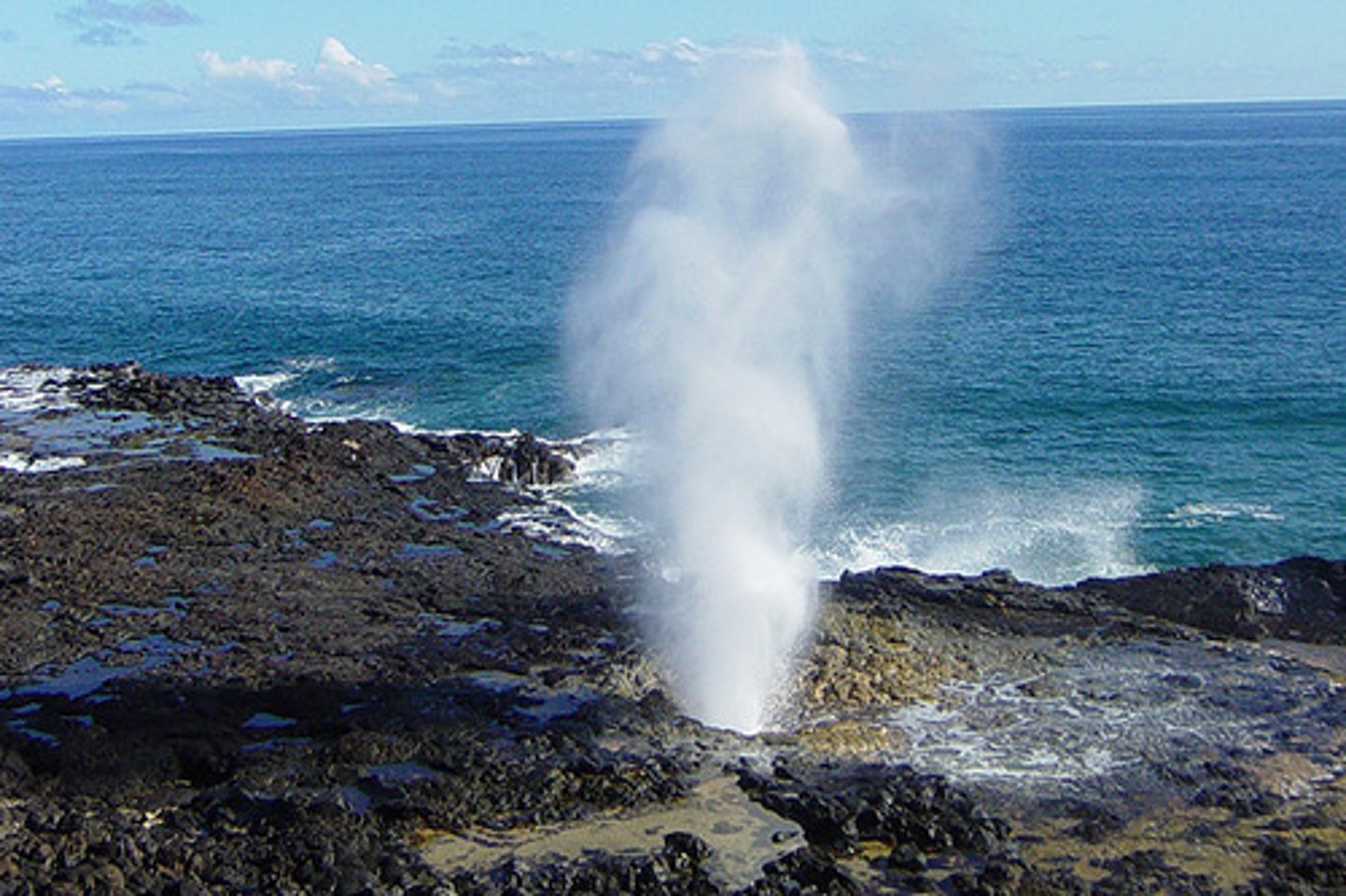
blowholes
caves, arches, stacks and stumps
= on headlands
... the concentrated wave energy attacks the headlands via hydraulic action and abrasion, eroding it away
1. hydraulic action infiltrates a crack/fault in the cliff, widening it
2. the fault grows into a cave via hydraulic action and abrasion
3. this continues to widen over time until the cave has been eroded all the way through the headland and forms an arch
4. this arch is further eroded by weathering and hydraulic action until the weight of the top becomes too heavy and is unsupported, so that the arch collapses and breaks off from the headland
5. this leaves a stack and the cliff retreats backwards
6. this stack is eroded at the bottom until the top is unsupported, casing it to collapse and leave behind a stump
e.g., Green Bridge of Wales, Pembrokeshire, South Wales
cliff erosion and wave cut platforms
= when waves break against the foot of a cliff, erosion via hydraulic action and corrosion tend to be concentrated close to the high tide line
... creates a wave cut notch
1. as the notch gets bigger the cliff is undercut and the rock above it becomes unstable, eventually collapsing
2. as erosional processes are repeated, the notch migrates inland and the cliff retreats, leaving behind a gently sloping wave cut platform which is only completely exposed at low tide
3. wave cut platforms rarely extend for more than a few hundred meters because a wave will break earlier and its energy will be dissipated before it reaches the cliff, thus reducing the rate of erosion and limiting further growth of the platform
(example of negative feedback)
coastal landing and cliff sway
wave energy is causing the cliffs at coastlines to flex and sway with the waves energy as measured by sensitive seismometers
1. as the swash comes in, the weight of water depresses the earths crust, causing the cliff to tilt forward as the wave cut platform drops slightly
2. as backwash pulls water away, cliff tilts back again
3. whole cliff face pivots back and forth
4. cliffs are always moving
5. huge amounts of seismic energy transmitted with the energy of the waves
6. when coupled with erosion, mass movement and weathering has an overall weakening effect on the cliffs
wave cut platform in Southerndown, Wales
cliff sway due to...
1. high frequency shaking caused by the waves impacting the cliff (wave quarrying)
2. gravitational loading induced "swaying" at the frequency of the waves
--> study in California reported that at high tides the following cliff top ground motions were generated locally by ocean waves at the cliff base
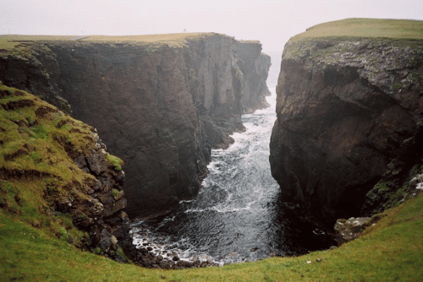
geos
= a specific inlet where there is no difference in geology which has caused the formation of a narrow inlet, only formed from some sort of mass movement or crack in the rocks where one are has slipped away
blowholes
= when a weakness/crack in the cliff is enlarged by wave erosion, forming a cave and part of the roof has fallen in to form a blowhole
... waves rushing into the cave may then splash up the blowhole inland