AP HuG Exam Review - Unit 6
1/108
Earn XP
Description and Tags
Name | Mastery | Learn | Test | Matching | Spaced |
|---|
No study sessions yet.
109 Terms
city
a relatively large, densely populated settlement with a much larger population than rural towns and villages; these serve as important commercial, governmental, and cultural hubs for their surrounding regions
agricultural surplus
crop yields that are sufficient to feed more people than the people than the farmer and his/her family
socioeconomic stratification
the structuring of society into distinct socioeconomic classes, including leadership (for instance, a government or ruling class) that exercise control over goods and people
first urban revolution
agricultural and socioeconomic innovations that led to the rise of early cities
Agri surplus, social stratification, job specialization
urban hearth areas
regions in which the world's first cities evolved; associated with defensible sites and river valleys around agri hearths
Tigris/Euphrates Rivers (Fertile Cerscent)
Indus River
site
Characteristics at the immediate absolute location. Ex:
Harbors, rivers, climate, labor force, human structures
situation
the relative location of a place in reference to its surrounding features, or its regional position with reference to other places
capitalism
an economic and political system in which a country's trade and industry are controlled by private owners for profit, rather than owned and run by the state.
communism
an economic and political system in which all property is publicly owned and managed (usually by the state/government)
Anti-urbanization bc creates class privilege
streetcar suburb
A settlement outside a city with streetcar lines; the streetcars take residents into and out of the city easily
second urban revolution
The industrial innovations in mining and manufacturing that led to increased urban growth
Industrial rev → ppl moving to cities for job opportunities
redevelopment
a set of activities intended to revitalize an area that has fallen on hard times
metropolis
a very large and densely populated city, particularly the capital or major city of a country or region
urban area
any self-governing place in the United States that contains at least 2500 people
urbanized area
In the United States, an urban area with at least 50,000 inhabitants.
urban cluster
In the United States, an urban area with between 2,500 and 50,000 inhabitants.
suburb
a populated area on the outskirts of a city
urbanization rate
The percentage of a nation's population living in towns and cities
Megalopolis
is a group of metropolitan areas which are perceived as a continuous urban area through common systems of transport, economy, resources, ecology, and so on; continuously developed string of cities
Ex: Bos-Wash Corridor - String of cities from Boston through New York, Philadelphia, Baltimore to Washington DC
suburbanization
the movement of people from urban core areas to the surrounding outskirts of a city
Causes of suburbanization after WWII:
Economic expansion: Grater purchasing power for families, car-centered lifestyle, highways built for commutes
Racial Tension - “White Flight” - AA migrated to cities for jobs/edu so whites left, go lacked investment in cities, industries and jobs left cities (decentralized) and so did residents
Continued govt investment in suburban growth and lack of investment in inner cities = urban decline and suburban growth. Industries and jobs left the cities, and residents followed
sprawl + reasons
The tendency of cities to grow outward in an unchecked manner. Reasons:
Growth of suburbs, cheaper land (Bid-Rent theory), lower density single-family housing, growth of car culture
As suburbs grew, businesses began to decentralize their operations
automobile cities
cities whose size and shape are dictated by and almost require individual automobile ownership
decentralize
In an urban context, to move business operations from core city areas into outlying areas such as suburbs
edge city + characteristics
a concentration of business, shopping, and entertainment that developed in the suburbs, outside of a city's traditional downtown or CBD; grew at major highway interchanges
Close to transportation routes
Nodes of economic activity in periphery of city
Mini downtowns with malls, restaurants, office complexes
Fewer residents than city
Populated during day (workers), leave at night to go home
boomburb (also called boomburg) + characteristics
rapidly growing community with more than 100,000 residents that is NOT a core city in a metropolitan areas; a large suburb with its own government
Rapidly growing
No dense urban center
Have their own downtown area
Found in metropolitan areas
Traffic congestion + Pollution
Ex → Plano, Texas
infill development
the building of new retail, business, or residential spaces on vacant or underused parcels in already-developed areas
Types of infilling:
Developing one or more new residences on an undeveloped site within a neighborhood
Redeveloping an existing neighborhood
Demolishing an existing home for a larger home
exurb + characteristics
a semi-rural district located beyond the suburbs that is often inhabited by well-to-do families
Rise of exurbs bc its become more common to work home after COVID
Remote working via tech
Cultural preferences
Expansive lots of land, single family homes
Ppl move here bc they want privacy
Limited service
Caused by counter-urbanization/deurbanization
Rise of automobiles and highway systems - ppl moving further but want the best of both worlds - country life and city amenities
world city
a city that is a control center of the global economy, in which major decisions are made about the world's commercial networks and financial markets (also called a global city)
NYC, London, Tokyo
Media hubs and financial centers, high-order services
Where key decisions about products, manufacturing, banking, cultural trends, marketing, and information originate
Decisions made by leaders of world cities impact EVERYONE
Largest cities are not always world cities; not about pop size but economic influence
Powerful transportation, communication, and businesses services
gated community
privately governed and highly secure residential area within the bounds of a city; often has a fence or a gate surrounding it
urban system
a set of interdependent cities or urban places connected by networks
urban hierarchy
a ranking of cities, with the largest and most powerful cities at the top of the hierarchy
rank-size rule + characteristics
the population of a settlement is inversely proportional to its rank in the urban hierarchy; the nth largest city will be 1/n the size of the largest city (rounding/estimates used)
More common in MDC’s
MDC’s = better infra. allowing for small, medium, and large cities (urban hierarchy) to develop & share resources (N.America/W.Euro)
Common in area with federal gov - sharing of powers
Sharing of power to local levels of gov allowing them to collect taxes and build up their infrastructure to develop medium cities
Size of city determines type of services:
Large city = high-order services: expensive, supports large # of people, occasionally used- luxury car dealerships, major sports teams, research hospitals
Small city = low-order services: less expensive, for lower pop, frequently used- gas station, local grocery store
Has midsized cities in between
More of a tendency than a rule
primate city + characteristics
a city that is much larger than any other city in the country and that dominates the country's economic, political, and cultural life
Both LDC’s & MDC’s- usually former center of colonial power
London, Moscow, Paris-centralized power for easy control over colonies
Unitary form of gov-strong central gov
Offer a wider range of services than smaller cities
Lack medium sized cities (unlike rank-size rule)
MDC’s like London-don’t need medium sized bc easy transp. to get there for services; Ex: Scotland= only a 2 hr flight
LDC’s like Mexico City-do NOT have mid-size cities and struggle to get services to those not in primate cities (lack transp.) → migrate to city for eco. opp. & greater services
central place theory
a model, developed by Walter Christaller, that attempts to understand why cities are located where they are
Central place - Location where people go to receive goods/services
Market area: zone that contains people who will purchase goods or services; surrounds each central place; hexagonal hinterlands
4 factors considered:
Type of people most likely to use the services
Maximum distance consumers were wiling to travel
Minimum # of people needed to support the services
Accessibility of service
Travel distances dictate the placement of settlements in the urban hierarchy and their surfaces
Low-order services (gas station, grocery store, regularly purchased household items) → Lower threshold and range
Medium-order services (restaurants, movie theaters, shopping malls)
High-order services (stock market exchanges, major sports teams [super bowl], research hospital, etc) → Higher threshold and range
Large cities can not be too close to each other because they would infringe on each others hinterlands
![<p>a model, developed by Walter Christaller, that attempts to understand why cities are located where they are</p><ul><li><p>Central place - Location where people go to receive goods/services</p><ul><li><p>Market area: zone that contains people who will purchase goods or services; surrounds each central place; hexagonal hinterlands</p></li></ul></li><li><p>4 factors considered:</p><ul><li><p>Type of people most likely to use the services</p></li><li><p>Maximum distance consumers were wiling to travel</p></li><li><p>Minimum # of people needed to support the services</p></li><li><p>Accessibility of service</p></li></ul></li><li><p>Travel distances dictate the placement of settlements in the urban hierarchy and their surfaces</p><ul><li><p>Low-order services (gas station, grocery store, regularly purchased household items) → Lower threshold and range</p></li><li><p>Medium-order services (restaurants, movie theaters, shopping malls)</p></li><li><p>High-order services (stock market exchanges, major sports teams [super bowl], research hospital, etc) → Higher threshold and range</p></li></ul></li><li><p>Large cities can not be too close to each other because they would infringe on each others hinterlands</p></li></ul>](https://knowt-user-attachments.s3.amazonaws.com/4877d39e-59f3-4425-bcc3-e5a79fc7451f.jpg)
central place
a settlement that makes certain types of products and services available to consumers
threshold
in central place theory, the number of people required to support businesses
range
in central place theory, the distance people will travel to acquire a good
Multiple-Nuclei Model
a model of a city's internal organization, developed by Chauncy Harris and Edward Ullman, showing residential districts organized around several nodes rather than one central business district
Chancy Harris and Edward Ullman, 1940s (around car invention)
Multiple nuclei instead of one CBD, decentralization and sprawl occurring due to cars/suburbanization, CBD less of a focal point
Each node attracted + repelled certain types of activities
Numerous zones of industry in various locations, including CBD, port, or outlying locations near an airport or other transp → attracted related industries and higher density housing
Ex: A university or business park - attracts nearby restaurants, theaters, might create a district of student housing or high-quality homes nearby
Galactic City (Peripheral) Model
a model of a city's internal organization in which the central business district remains central, but multiple shopping areas, office parks, and the industrial districts are scattered throughout the surrounding suburbs and linked metropolitan expressway systems (such as a beltway or highway)
Chuancy Harris, 1950s (suburban growth skyrocketed as govt built highways easing transport to/from cities)
Based on decentralized Detroit, Michigan
CBD central, but multiple shopping areas, office parks, and industrial districts are scattered through the surrounding suburbs and linking by ring road or beltway-white rim
Functional zones with nodes, once large enough they became edge cities - ALL around ring beltway transp system
CBD do high rise buildings surrounded by sprawl and includes edge cities near highways
Left behind declining inner city
Most employment opp found in edge cities
CBD no longer heart
Poor near industrial district, middle-class around office parks and closer to suburbs
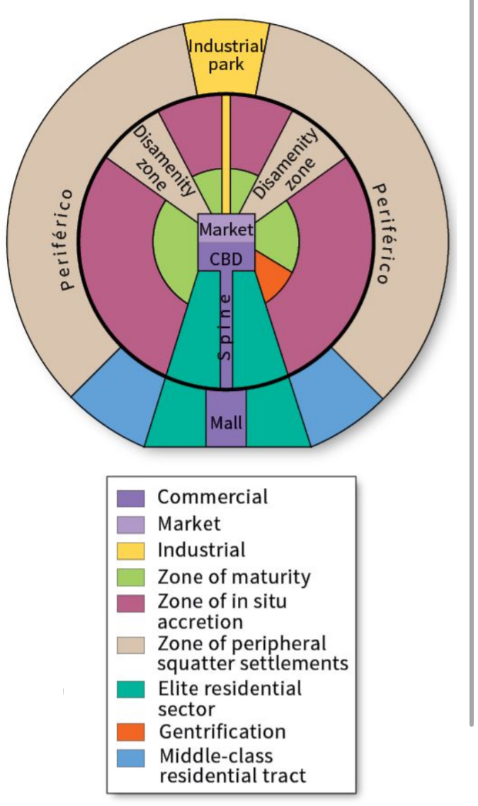
Griffin-Ford (Latin American City) Model
A model of the internal structure of cities in less developed countries; developed by Ernst Griffin and Larry Ford; cities were planned and designed using the Law of Indies, are built around a central plaza/market place, include a spine where the wealthy live in the interior of the city, and includes squatter settlements along the periphery of the city
Larry Ford and Ernest Griffin
1980, most applicable to metropolitan areas that were once colonial-era Spanish cities
Traditional elements of Latin American culture mixed with globalization
Extreme difference between areas for privileged and poverty
Zones:
CBD → 2 parts; high quality housing
Traditional market center - sells every day goods
Modern high-rise center - focuses on primary business, entertainment, employment
Commercial Spine - Connects CBD to mall; high quality housing, theaters, restaurants, parks along it and ends in theaters secondary center (mall)
Market on opposite side - has spine connecting to industrial park
Zone of maturity - Rings CBD/market w/middle-class and good housing
Has small gentrification sector: low-income displaced by high-income as area improves
Zone of Situation Accretion - Transition between older area of central city and poorest part of city; lower middle-class
Periferico - Poverty, lack of infra, shantytowns/squatter settlements: areas of poorly built housing
Disamenity zone - favelas and barrios: Neighborhoods marked by extreme poverty, homelessness, and lawlessness
Not connected to city services (electricity, water supply), physically unsafe
Structures poorly con structures, densely packed
As distance from the center of Latin American cities increases, the quality of housing decreases
Public transportation, the urban water supply, and access to electricity all decrease farther away from the center, sometimes disappearing altogether
Sub-Saharan African City Model
a model of the internal structure of cities in less developed countries; developed by Harm De Blij; unique characteristics include three central business districts - colonial business district, original business district, and informal marketplace business district; there are no distinct residential zones for the wealthy/poor due to poor economics for the entire city, people are separated more by ethnicities/tribal connections, large squatter settlements on the periphery of the city
Traditional CBD - Before euro colonization, small shops clustered along narrow winding streets, formal economy
Colonial CBD - Straight avenues, large homes, parks, admin centers, informal economy - temp workers don’t follow regulations, periodic markets
Zone of Mining and Manufacturing
Residential Zone - Based on ethnicity, show multiethnic makeup of Africa
Periphery of Cities - Densely populated squatter settlements lacking public services for electricity, water, and sewage, like LA favelas - crimes and drugs
NO exclusive residential zone for the wealthy, unlike all the other models
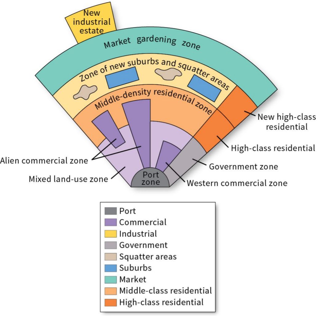
McGee (Southeast Asian City) Model
a model of the internal structure of cities in less developed countries; developed by Terrance McGee; unique characteristics include no central business district, but a port zone instead; separate residential and commercial zones for foreigners, new industrial estates on the outskirts of the city due to increased industrialization and manufacturing in more recent times
T.G. McGee
Describes the land use of many large cities where the focus is often a former colonial port zone; export oriented zone
Zones:
Focal point NOT a CBD, but the Old Colonial Port Zone
Alien Commercial Zone - Chinese immigrants, residence attached to place of business
Mixed Land Use - Many different economic businesses
Market Gardening Zone - Light agriculture supplies city
Squatter Areas + Suburbs - Middle-class
Differences w LA model and NA models
NA → Squatters/poorer in the outer city whereas SEA model shows middle-class in outer city limits
LA → SEA model has market gardening zone
gentrification
the displacement of lower-income residents by higher-income residents as an area or neighborhood improves
zoning regulation/ordinance
laws that dictate how land can be used
Residential - Where people live
Commercial - Where people/businesses sell goods and services
Industrial - Where businesses make things
fiscal squeeze (problems+solutions)
occurs when city revenues cannot keep up with increasing demands for city services and expenditures on decaying urban infrastructure
Problems:
Cities lost residential pop and commercial establishments to suburban areas → Abandoned housing, lack of jobs, vacant warehouses, neglected neighborhoods, and crumbling infrastructure
Migration of middle/upper-class to suburbs → decrease in city’s tax base = less tax revenue
Plus, city occupied by elderly or poor → need welfare services and no income to be taxed
Solutions (ish)
Cities tracking/developing businesses - sports franchises, business/conference centers, tourist attractions, and large businesses
However, requires expensive infra that leads to more FS (parking, sewage)
City offers fiscal adv → reduction in taxes to business; again = less revenue and more fs
built environment
the human-made space in which people live, work, and engage in leisure activities on a daily basis
smart growth
policies that combat regional sprawl by addressing issues of population density and transportation
compact design
Development that grows up (in the form of taller buildings) rather than out (in the form of urban sprawl)
diverse housing options
policy that encourages building quality housing for people and families of all life stages and income levels in a range of prices within a neighborhood
New Urbanism
an approach to city planning that focuses on fostering European-style cities of dense settlements, attractive architecture, and housing of different types and prices within walking distance to shopping, restaurants, jobs, and public transportation
Walkability
Connectivity
Mixed use and diversity
Diverse housing operations
Quality architecture and urban design
Traditional neighborhood structure
Increased density
Smart transportation
Sustainability
Quality of life
greenbelt + characteristics
a zone of grassy, forested, or agricultural land separating urban areas
Promote healthy lifestyle/enjoy recreation
Promote ecological health
Limit urban sprawl
If used for agri, farmers benefit from being closer to city
City ppl also get access to fresh food
Economic benefits → Agri jobs, tourism
Started in London
zoning
the classification of land according to restrictions on its use and development
slow-growth city
A city that changes its zoning laws to decrease the rate at which the city spreads horizontally, with the goal of avoiding the negative effects of sprawl
anti-displacement tenant activists
Advocates for poor and working-class residents who are at risk of losing their affordable housing to new development
de facto segregation
racial segregation that is not supported by law but is still apparent
redlining
the practice of identifying high-risk neighborhoods on a city map and refusing to lend money to people who want to buy property in those neighborhoods
blockbusting
a practice in which realtors persuade white homeowners in a neighborhood to sell their homes by convincing them that the neighborhood is declining due to black families moving in
affordability
the maximum price that a buyer can afford to pay for a house or apartment
housing choice voucher program
a federal government program to assist very-low-income families, the elderly, and the disabled with affordable, decent, safe, and sanitary housing
violent crime
a category of crime that includes murder, rape, robbery, and aggravated assault
social controls
formal and informal institutions that help to maintain law and order in place
environmental injustice
occurs when certain groups carry a larger share of environmental risks and hazards than groups who have the power to influence decisions about the environment
Leads to increased health problems, birth defects, cancer, shorter avg life expectany
environmental racism
occurs when areas inhabited by low-income people of color are targeted for environmental contamination
environmental justice
the movement to fix environmental discrimination
squatter settlement
An area of degraded, seemingly temporary, inadequate, and often illegal housing
land tenure
the right to own or hold property; it defines the ways in which rights to that property are managed
inclusionary zoning (IZ)
municipal and county planning ordinances that require a given share of new construction to be affordable for people with low to moderate incomes
exclusionary zoning
Zoning that attempts to keep low- to moderate-income people out of a neighborhood
NIMBYs
Abbreviation for "not in my backyard"; term for people who try to prevent the construction of affordable housing and other types of development in their neighborhood
urban renewal
large-scale, government-funded redevelopment of the built environment in downtown and older inner-city neighborhoods
Started after WWII when ppl moved to suburbs and cities decayed
Pros:
Newer infra, builds up inner city, more amenities for public
Cons
Residents have NO say, displaces minorities and low income
fiscal zoning
the practice of using local land-use regulation to preserve and possibly enhance the local property tax base
ecological footprint
the total amount of natural resources used and their impact on the natural environment
urban canyons, flooding, heat island, vegetation, and footprint
Urban Canyon:
Streets lined with tall buildings - channel and intensify wind, block sunlight from ground
Urban Flooding:
Soils compacted and replaced with buildings/streets/parking lots - more runoff instead of absorption
Urban heat Island:
a mass of warm air in cities, generated by urban building materials and human activities, that sits over a city
Urban Vegetation:
Influences quality of groundwater, reduces wind speeds and temps, absorbs air pollution, etc
Urban footprint:
Spatial extend of an urban areas impacts on the natural environment
urban footprint
The spatial extent of the impacts of urban areas on the natural environment.
urban risk divide
the idea that disasters and disaster risk become urban phenomena as the world's population becomes increasingly concentrated in large cities
brownfields
properties whose use or development may be complicated by the potential presence of hazardous substances or pollutants
brownfield remediation
The process of removing or sealing off contaminants so that a site may be used again without any health concerns
Farmland Protection Policy (FPPA)
U.S. law that grants municipalities oversight over federally funded development projects on farmland
scattered developments
Subdivisions or developments that do not border on existing settlements and that remove agricultural land from production
perceived density
the general impression of the estimated number of people present in a given area
Characteristics needed for urban settlements/cities
The presence of an agricultural surplus (support larger pop. and had extra to spare)
The rise of social stratification (classes) and a leadership class or urban elite (ruling class/gov. org a way to store/distribute food & controlled people living in the community)
The beginning of job specialization (not everyone needed in agri. →specialized→making tools, weapons, art, as well as religious leaders)
Urbanization
Ongoing process of developing towns and cities
Does not end once a city is formed
City-State
Consisted of an urban center (the city) and its surrounding territory and agricultural villages
Own political system and functioned indep. from other C-S
Village/Territory received services and protection from the urban center
Often raided for wealth ╸ Defense= primary consideration -military leaders evolved into political rulers, or kings
Ex: Classical Greece (Athens, Sparta), Venice and Italian city-states during the Renaissance; Monaco, Vatican City, Singapore
Metropolitan Area
Collection of adjacent (neighboring) cities economically connected with high and continuous population density; metro areas
Metropolitan Statistical Area
Consists of a city of at least 50,000 people; the country and adjacent counties have a high degree of social and economic connection with the urban core
Brochert’s Model of Urban Growth
Describes how urban growth is based on transportation technology. He divided urban history into four periods, called epochs
Epoch: Sail-Wagon
1790-1830
Water ports became very important
Poor road conditions made long-distance travel between cities difficult
Epoch: Iron Horse
1830-1870
Stefan engines powered boats, promoted growth of river cities
Regional rail networks connected cities
Rail lines connected resources and industrial sites
Epoch: Steel Rail
1870-1920
Transcontinental railways emerged, cities emerged along rail lines in the interior of continents
Epoch: Auto-Air-Amenity
1920-1970
Cars allowed cities to spread out
Airport hubs emerged, cities became far more interconnected
Megacities
Regional population of over 10 million
Cairo, Egypt
Mumbai, India
Beijing, China
Dhaka, Bangladesh
Osaka-Kobe-Kyoto, Japan
Metacities
Regional population over 20 million
Tokyo, Japan
Delhi, India
Shanghai, China
Sao Paulo, Brazil
Mexico City
Wave of development
First, homes move to suburbs → Second, moving retail to where we live (decentralization) → Third, edge cities - move jobs to where people live
Nodal cities
Command centers on a regional and occasionally national level; not as powerful as world cities but lots of power writhing a region of a country
Denver, Phoenix, Minneapolis
Some corporate headquarters
Regional offices for transnational companies
Major entertainment, cultural, & economic centers in region
To maintain global connectivity → have dev. road systems/airports & advanced comm. networks that connect smaller cities to world cities
Cities specializing in certain functions= another level of UH-Austin, TX (government), Las Vegas, NV (entertainment), Elkhart, IN (manufacturing), Norfolk, VA (military)
Limitations of Rank-Size Rule
Does not explain distribution of cities or interaction btwn cities
Can’t compare two cities in diff. countries bc define cities differently; works better for using metropolitan areas
Assumptions behind Central Place Theory
Flat surface, no barriers such as mountains
Same soil quality
Evenly distributed population and purchasing power
inform transportation linking settlements to each other
From any place, any good/service sold in all directions
Gravity Model + Uses/Limitations
Idea that larger and closer places will have mor interaction than places that are smaller and farther; distance decay - also takes into account distances between two cities and their size
Uses:
To predict flow of workers, shoppers, migrants, information, economic activity, etc
More flows to big cities and between nearer cities
NYC and NJ are a metro region w incr public transport BUT NYC and LA also have a lot of interaction, even though they’re on opposite sides of US
Limitations:
Assumes locations with no barriers
Not accounting for how political, physical, or cultural barriers influence interaction between cities
Tourist attractions, religious sites, govt centers distort model
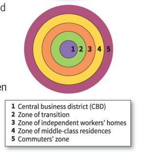
Concentric Zone Model
a model of a city's internal organization developed by E.W. Burgess organized in five concentric rings that model the arrangement of different residential zones radiating outward from a central business district
Created by E.W Burgess, 1920s
Based on Chicago, Illinois
Five zones (center to outward):
CBD → Downtown, high density, commercial heart of city, focus of transport and services
Transition zone → Mixed industrial uses w low-cost deteriorating housing; high density, city-center workers
Low-Cost Residential → Working-class housing, some stability/better neighborhoods
Moderate-Cost Residential → Middle-class family housing; suburbs more expensive
Commuters Zone → Expensive, larger homes in the exurbs; low density, ppl who work here can afford to commute into the city every day to work
Poor in second and third ring (interior of city) while rich are in fifth ring (outskirts of city)
Criticism: Doesn’t apply to many cities
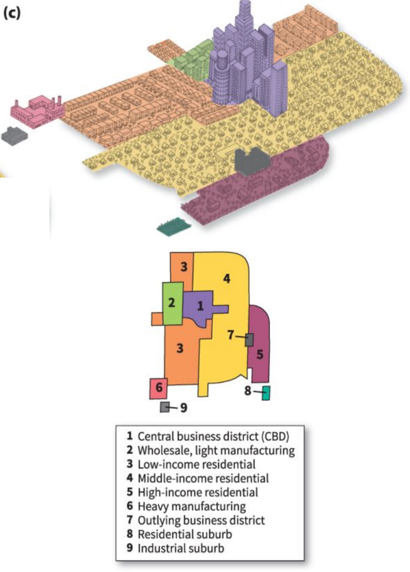
Hoyt Sector Model
a model of a city's internal organization, developed by Homer Hoyt, that focuses on transportation and communication as the drivers of the city's layout and organizes residential areas as wedges radiating outward from a central business district
Homers Hoyt, 1930s
Based on Chicago, IL
City’s organization focused on transportation and communication as determining factor for city’s layout; wedges
5 Zones (center - outward):
CBD → Downtown, high density
Manufacturing and industry → SOME lower-class housing, followed a major route of transportation (railway, road, canal, harbor) area for FAST and CHEAP transport of products
Low-Income Residential → Working-class housing, along manufacturing area so people get to their jobs, ethnic neighborhoods from immigration
Moderate-Income Residential → Middle-class housing, suburbs
High-Income Residential → Upperclass housing, along transport line, extends outward from CBD
Poor are in third zone, following industrial sector where they worked. Rich are in fifth sector
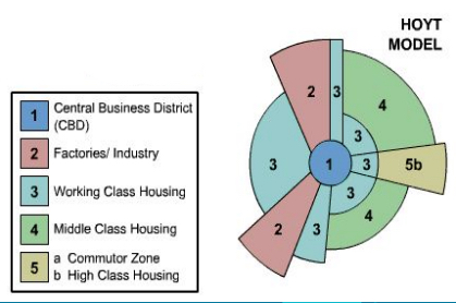
Similarities and Differences between Burgess and Hoyt
Similarities:
Growth outward from CBD = higher income people and lower income near CBD/industrial zone
Homes/property size larger the farther out from CBD bc Bid Rent Theory (cheaper land further out)
CBD is in the center
Differences:
Brgess based on sociology and Hoyt on economics
Burgess → concentric rings
Hoyt → wedges
Urban Bid Rent Theory
The further away from the CBD, the cheaper the land; inverse relationship
Residential Zones
Ordinances set limits on the density and size of houses in specific zones - only large homes, only small homes, only apartment buildings
Pros/Cons of Zoning Regulations
Pros:
Various areas created to meet peoples’ specific life styles/wants
Separate loud industrial areas (noise/air pollution) from residential areas
Can promote growth of communes through redevelopment or infill development
Cons:
Can prevent socioeconomic or cultural diversity
Decentralization occurs in wealthier areas decrease job opportunities and consumer choices and services in less valued areas
Prevents mixed-use (residential and commercial) creating walkability and diverse communities
Municipal + Municipality
Municipal → Refers to the local govt of a city or town and the services it provides
Municipality → Refers to a local entity that is all under the same jurisdiction