AP Human Geography Unit 6
1/63
Earn XP
Name | Mastery | Learn | Test | Matching | Spaced |
|---|
No study sessions yet.
64 Terms
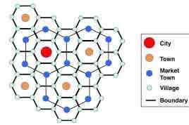
Central place theory
States that settlements are located una hierarchical pattern, with larger settlements serving as central places that provide goods and services to smaller settlements in the surrounding area
created by Walter Christaller in 1933
Seeks to explain the number, size, and location of human settlements in an urban system
Megacities
Urban areas with a population of over 10 million people
eg Paris
Metacities
Urban areas with a population exceeding 20 million people
Eg. Tokyo
Challenges of urbanization
traffic
Pollution
Crime
Waste
Rising property prices
Rank size rule
An observation about the relationship between population size and city ranking within a country
second largest city will be ½ the size of the largest city, third largest city will be 1/3 the size the largest city, etc.
Eg. The US
Primate city
The largest city in its country or region, significantly larger than any others in the urban hierarchy
typically the economic, political, and cultural hub of the country
Disproportionate influence over the rest of the country
Alpha cities
Plays a significant role in the global economic network
primary hub for finance, commerce, trade, arts, culture, etc.
direct impact on economic and political global affairs
Beta cities
A city that links moderate economic regions into the world system
important but not vital to global economic functions
Eg. Chicago, Barcelona, Amsterdam
Gamma cities
A city that links smaller regions or countries into the world system
less influence than alpha or beta cities
Metropolis
A very large city often regarded as the central or main city of a country or region
large population, offers many services
Megapolis
A chain of roughly adjacent metropolitan areas, which are interconnected with each other
this term can be used to describe a region that consists of several large cities and their surrounding areas in close proximity
Urban structure models (city models)
Theoretical frameworks that represent the structure and organization of cities, explaining how different areas within a city serve different purposes
Concentric Zone Model
An urban model designed by Ernest Burgess suggesting that cities grow outward from a central area in concentric rings (like the layers of an onion)
center is the most densely populated and developed area
Social and economic characteristics tend to be homogeneous within each zone
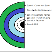
First layer of concentric zone model
CBD
Second layer of concentric zone model
Transition zone
Third layer of concentric zone model
Low income housing zone
Fourth layer of concentric zone model
Middling income housing zone
Fifth (outer) layer of the concentric zone model
Commuting zone
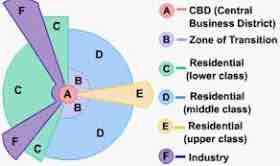
Sector model
An urban land use model proposed by Homer Hoyt in 1939 suggesting cities develop in sectors, rather than rings, and these sectors extend out from the CBD
determined by transportation accessibility, land availability, and social/economic factors
Each sector has a distinct social structure
Outer regions characterized by residential land use
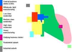
Multiple nuclei model
Developed by geographers C.D Harris and E.L Ullman in 1945 and suggests that a city develops around several centers, each serving a different purpose
location and type of land use within a city is determined by a combination of transportation accessibility, land availability, and social/economic factors
No CBD
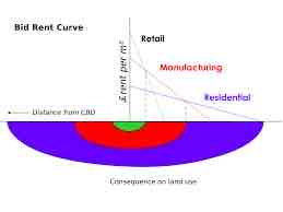
Bid-rent theory
Land/real estate/ rental costs are higher in and around a city’s central businesses district due to demand
peripheral model (galactic city)
Proposes that large, sprawling developments on the outskirts of metropolitan areas are becoming a distinctive feature or contemporary urban landscapes
home to white-collar workers who commute to the city center for work
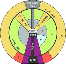
Latin American City Model
Shares similarities with the concentric zone and sector models
center market shares CBD with a modern business center plus religious and government buildings
Wealthy residents live in the blocks adjoining both sides of the spine
A radial Road circles the city
Disamenity zones are high-poverty areas that often include squatter settlements
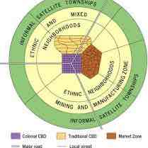
African city model
concentric rings and sectors radiating from the center
Has 2 CBDs: created by colonial power, traditional, a zone for open-air markets
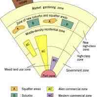
Southeast Asian City Model
Represents Southeast Asian cities that grow around ports and lack a clearly defined CBD
only two formal zones remain constant: the port zone and a zone of intensive market gardening on the periphery
Share characteristics with the concentric model
Land-use segregation
Things such as economic activities, housing types, ethnic groups, and government zones all tend to be in discrete zones
Areal differentiation
The process of distinguishing one geographical area or region from another based on its unique physical and cultural characteristics
zoning
municipal or local laws or regulations that govern how real property can and cannot be used in certain geographic areas
Suburban sprawl (suburbanization)
The growth of cities outside of an urban area
Edge city
An urban area with a large suburban residential and business area surrounding it
Exurbs
Residential, prosperous, but rural areas beyond the suburbs
Leapfrog development
When developers skip over land to obtain cheaper land further away from cities, thus, leaving huge areas empty between the city and the new development
Squatter settlements
A collection of buildings aimed to provide housing and shelter for poor people in a city
people who live here do not have legal rights to the land
Favelas
A slum or shantytown located within or on the outskirts of the countries largest cities
Disamenity zones
The very poorest parts of cities that in extreme cases are not even connected to city services
Infrastructure
The basic physical and organizational structures needed for a society to function
High-density housing
Eg. High rise apartment complex
Medium-density housing
Eg. A suburb with more than 1,000 people living within a square mile
Low-density housing
An exurb where neighboring houses each own an acre of land
Infilling
Where open space presents an economic opportunity for landowners to build small multi-family housing units, placing more people into existing city blocks
Urban filtering
The process by which homes depreciate in quality as they age and tend to be occupied by lower-income households
Sustainable design
Optimizes building performance and minimizes negative impacts on building occupants and the environment
Smart Growth
An overall approach of development and conservation strategies that can help protect our health and natural environment and make our communities more attractive, economically stronger, socially diverse, and resilient to climate change
Smart growth policies
mix land use
Take advantage of compact building design
Create a range of housing opportunities and choices
Create walkable neighborhoods
Foster distinctive, attractive communities with a strong sense of place
Preserve open space, farmland, natural beauty, and critical environments
Strengthen and direct development towards existing communities
Provide a variety of transportation choices
Make development decisions predictable, fair, and cost effective
Community and stakeholder collaboration in development decisions
Urban sprawl
The uncontrolled expansion of urban areas into rural areas due to population growth over time
characterized by low-density residential housing units located relatively far from from commercial centers
New urbanism
A planning and development approach that promotes walkable, mixed-use neighborhood design, diverse populations, and spaces that are vibrant and human scaled
promotes environmentally friendly habitats
Slow-growth cities
Slow the pace or development to retain sense of place and preserve open space
part of smart growth policies
Urban growth boundaries
Borders to a city’s edges to limit how far a city can expand outward
Greenbelt
Areas of undeveloped, wild, or agricultural land surrounding or neighboring urban areas
designed to limit urban sprawl and preserve natural environment
West European City model
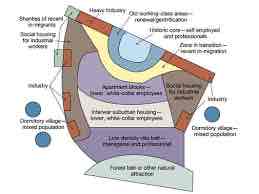
Urban filtering
The process of subdivision of houses and occupancy by successive waves lower-income
less maintained building
Lower rent costs
Redlining
When a lending institution refuses to offer home loans on the basis of a neighborhood’s racial or ethnic makeup
Blockbusting
When real estate agents would stir up concern that African-American families would soon move into a neighborhood to convince white property owners to sell their houses at below-market prices
gentrification
Process of changing the character of a neighborhood through the influx of more affluent residents and businesses, often displacing current inhabitants in the process
leads to renovation of older buildings and increases property value
Causes alterations or loss of cultural or historic landmarks
Affords housing
The financial capacity of individuals or families to rent or buy adequate housing without compromising other basic needs
Inclusionary zones
Municipal and county planning ordinances that require a given share of new construction to be affordable by people with low to moderate incomes
Public housing
Government-subsidized residential buildings provided for low-income families
Rent control
A government program that places a ceiling on the amount that a property owner can charge for leasing a home or renewing a lease
Urban growth boundaries
separates urban areas from the surrounding natural and agricultural lands
eg. Greenbelts
Farmland protection
Discourages Federal activities that would convert farmland to non agricultural purposes
Urban renewal
A process of land redevelopment often used to address urban decay in cities
Brownfields
Abandoned or underused industrial/commercial facilities where redevelopment is complicated by environmental contamination
Grayfields
Underutilized real estate or land area
things like shopping centers/malls are especially susceptible to this as their layouts no longer meet current trends
Urban infilling
Can redevelop these areas and put the land to better use