Geology quiz/lab
 Call Kai
 Learn
Learn Practice Test
 Spaced Repetition
 Match
Match Flashcards
 Knowt Play
1/76

There's no tags or description
Looks like no tags are added yet.
Name | Mastery | Learn | Test | Matching | Spaced | Call with Kai | Chat |
|---|
No analytics yet
Send a link to your students to track their progress
77 Terms
Streams evolve and start to develop bends or turns over time. What are these "bends/turns" called?
Meanders
The amount of water moving down a stream per given time is called_________?
Discharge
The total area drained by a stream and its tributaries is called_________?
Drainage Basin
Urban areas caused rain water to run off faster than usual and make flooding worse.
True
What kind of river drainage pattern do we see here in the Ozarks?
Dendritic
Shale is a common _____ because it reduces the flow of groundwater.
Aquitard
You dig into the ground. 10 feet down you've hit water. What have you just come into contact with?
The water table
________ refers to the ability of a rock to transmit fluids.
Permeability
________ will likely make a good aquifer.
Gravel
What type of rock do caves USUALLY form in?
(The ones with cave formations like stalactites)
Limestone
water comes from in arkansas?
Beaver Lake
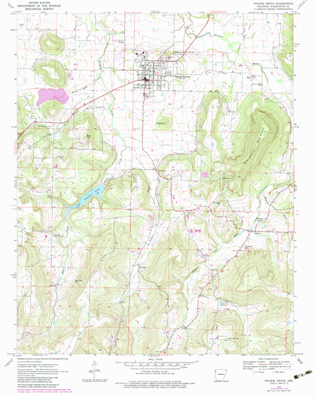
Scale of this map?
1:24000 (bottom middle page)
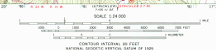
year map was published
1970 bottom right side

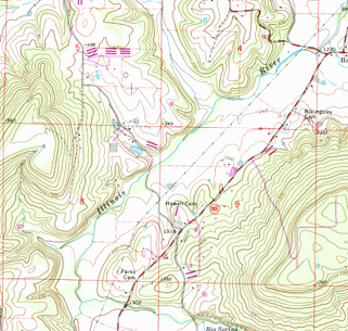
The Illinois River is on the map. You can see it in the South, then it bends to the East and then you can see it again to the North. What direction is it generally flowing? Hint: (Remember, contours "V" UPstream)
North
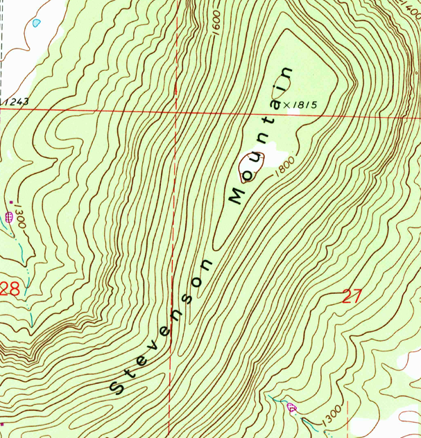
There's an X on top of Stephenson Mountain (The big one in the east). If you hiked to that X, what would you find?
A benchmark
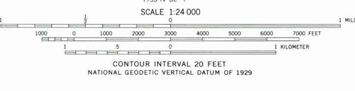
What's the contour interval of this map?
20 feet
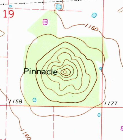
About how high is that "pinnacle" just south of Prairie Grove?
1325'
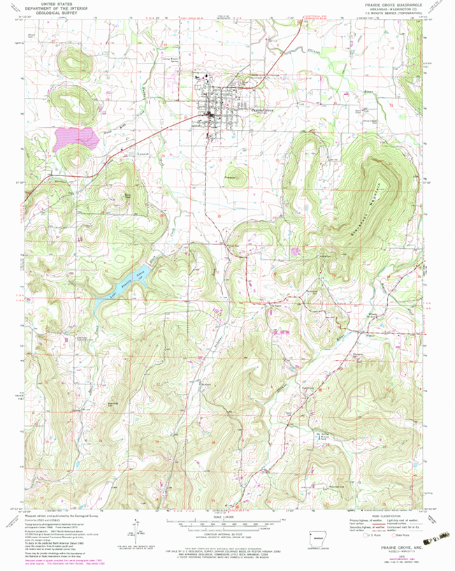
Which is easier, hiking east-west across the very Northern portion of this map, or hiking east-west anywhere in the South portion of this map?
North
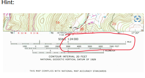
Using the scale, about how many miles would you have to drive to get from Prairie Grove, to Hogeye in the southeast?
4
What shape does a glacial valley make?
u
What is the sediment eroded from mountains by glaciers called?
Till
How do glaciers accumulate and grow?
More snot falls each year than melts
There were glaciers in Arkansas during the ice ages of the last ~2 million years.
False
Where are the majority of glaciers found on Earth today?
Antarctica
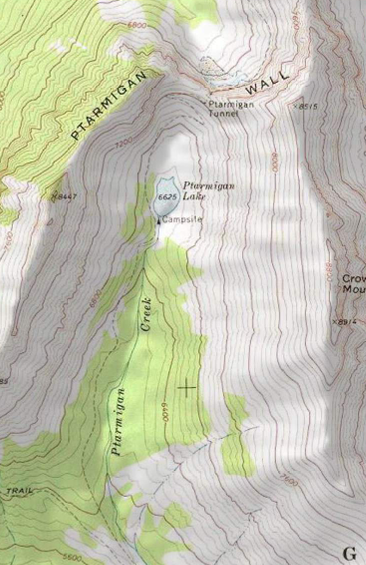
Find Ptarmigan Lake in the middle of the 2nd map. What glacier feature is surrounding it?
Cirque
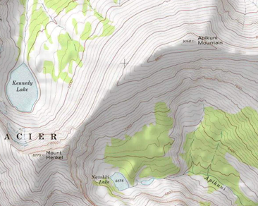
On the 3rd map. What's the feature between Apikuni Mountain and Mount Henkel?
Arete
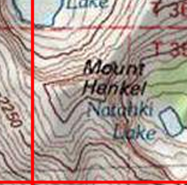
On the 1st(probably shows it the best), 2nd, or 3rd maps. What is the glacier feature that Mount Henkel represents?
Horn
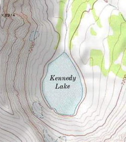
What is Kennedy Lake? (Not hard to find)
A Tarn
Notice that the valleys on these maps are all quite flat (contour lines aren't as close together). This is showcasing that "U" shape. What do you think is covering these flat valleys?
Till
A break in a rock formation where NO movement(displacement) has occurred is called?
A Joint
Dip is always perpendicular to strike.
True
Bending in layered rocks is called ______.
folding
What kind of fault is the result of tensional stress?
Normal
Which is NOT a type of Strain?
Fissile
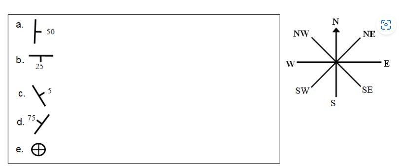
A)
North South
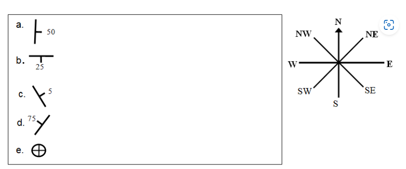
B)
East West
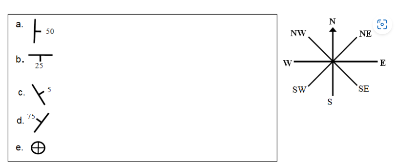
C)
Northwest Southeast
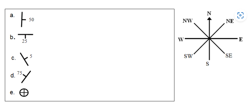
D)
Southwest Northeast
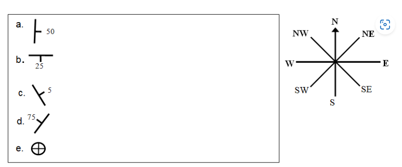
E)
Horizontal bedding
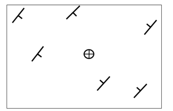
Above is a map with strike and dip symbols on it. What type of structural fold can you interpret from the strike and dip symbols provided on the map?
Syncline
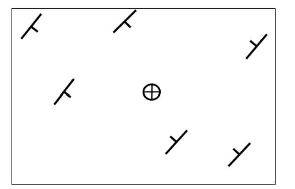
This is the same as question two. This time, which way is the AXIS of the fold pointing? (North is up)
Northeast
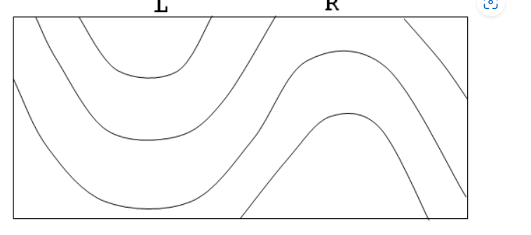
This is a Cross Section. It's a side-ways view of rocks. Like looking at the rocks along a road cut.
The fold under L is a __________ and the fold under R is a ______________
Syncline, anticline
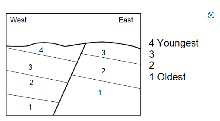
Above is a cross section of a fault (diagonal line in the middle). 1-4 are rock layers. Based on what you learned in my lecture about normal faults and reverse faults, what kind of force is being exerted on these rocks to create the fault?
Tensional
Which type of Earthquake waves arrive first?
Which type of waves can travel through liquids?
P-waves
How many Seismometers would you need to detect an Earthquake in order to pinpoint its epicenter?
3
Where is the New Madrid Seismic Zone located?
North Eastern Arkansas
Using the Richter scale. How much more powerful is a magnitude 7.0 earthquake vs a magnitude 5.0?
100 times
Where is oceanic crust created?
mid-oceanic ridges
What can you find at an active continental margin that you won't find at a passive continental margin?
Oceanic Trench
___________is used to study the subsurface geology underneath the ocean floor.
Both of those other answers(Seismic Surveying/ Dilling,Coring
Where did (at least some) the water in the oceans originally come from?
Comets
Which is steeper?
Continental Slope
Sea floor mining
Some benefits it can provide include important minerals for things like batteries, phones, and creating jobs land, Overall, I think we should be more careful and do more research before moving forward.
What are the sedimentary structures(beds) called that form from migrating dunes?
Crossbeds
What force dominates erosional and depositional features in deserts?
water
Where do deserts typically form?
At 30 degrees latitude on the Earth
Thick silt beds deposited by blowing winds is called?
loess
What's a "rain shadow desert" the result of?
Mountains blocking moisture
What large sedimentary environment/feature do we find in the basin and range province?
Alluvial Fan
What generates most waves?
wind
Irregular coastlines can get eroded and straighten by what?
Refraction of waves
Continental Beaches are mostly made up of what mineral?
Quartz
You're the mayor of Podunk Coast (congrats on your election). Your town has a harbor inside of a bay. The mouth of your bay is filling up with sediment migrating down from a river to the North. What can you build to help you stop the sediment from closing up your bay?
Jetty
Longshore currents can deposit sand and create what feature?
Barrier Island
Which one of these is NOT a greenhouse gas.
O2
True or False. Methane(CH4) is a more powerful greenhouse gas than Carbon Dioxide(CO2)
True
The changes we're seeing in the climate now are faster than any changes we've seen in the geologic record.
True
What is global warming?
Average temperature of the atmosphere and surface of the Earth warming over time.
What is the dominant landform-shaping agent on Earth?/Most shaping of desert landforms is the result of
running water
Steep, jagged topography in high-altitude mountain ranges is most likely the result
glaciation
Which of the following is most likely the result of the action of a stream?
alluvial fan
Which of the following is the result of groundwater action?
sinkhole
What is groundwater?
all liquid water that resides beneath the Earth's surface
Caves form chiefly in limestone bedrock because
limestone is composed of calcite which is soluble in meteoric water
The Ozark region structurally and topographically most resembles which one of the following region
Appalachian Mountains
Which type of bedrock is most likely to give rise to caves, sinkholes, and losing streams?
limestone
Which mass-wasting process is most widespread, occurring on virtually the entire land surface?
creep