12 - Meteorology 2
1/92
There's no tags or description
Looks like no tags are added yet.
Name | Mastery | Learn | Test | Matching | Spaced | Call with Kai |
|---|
No analytics yet
Send a link to your students to track their progress
93 Terms
The best indication of relative humidity is
the temperature and dew point spread.
During condensation a gas becomes a liquid. As a result,
the gas gives up heat as it changes to a liquid.
The change of state involved when a gas becomes a solid is known as
deposition
Freeze drying is an example of
sublimation
Environmental lapse rate is known as the
actual drop in temperature with increase in altitude.
Given: Surface temperature 20°C
Dew point 5°C
Elevation 1 000 feet ASL
The expected cloud base is
Calculate Spread: Temp 20°C - Dew Point 5°C = 15°C / 3°C = 5 x 1 000 feet = 5 000 feet Cloud Base AGL
Cloud Base 5 000 feet + Elevation 1 000 feet = 6 000 feet Cloud Base ASL
The correct answer is: 6 000 feet ASL.
Given: Surface temperature 18°C
Dew point 3°C
Elevation 523 feet ASL
The freezing level is at
Temp 18°C - DP 3°C = 15°C / 3°C = 5 x 1 000 = 5 000 feet AGL cloud base
Dew point 3°C / 1.5°C = 2 x 1 000 - 2 000 feet above cloud base + cloud base 5 000 = 7 000 feet AGL
The correct answer is: 7 000 feet AGL.
As rain begins to form in a cumulonimbus cloud condensation of the warm air
gives off heat and feeds the updraft.
Snow is formed during the process of
deposition
Ice pellets at the surface indicates
a layer of air that is above-freezing temperatures over a layer of air at the surface that is below-freezing temperatures.
Freezing rain does not freeze until contacting the ground or an object because
the drops remain supercooled.
Questions asks the formation of freezing rain. The rain has to become super cooled to becoming freezing rain. So the rain needs to fall into below 0°C temperature for a long enough time to become super cooled. That is why the answer rain falling from warm air into below 0°C temperature air, which is an inversion.
Rain hitting the ground and instantly freezing is not necessarily freezing rain. It could be rain just hitting really cold ground. One example that happened with me was flying at night while doing my night rating in the fall. It started to rain and it was not collecting on the aircraft but it was freezing on the runway. My instructor got quit tense as we used most of a 3 000 foot runway using short field landing procedure. Really slippery.
The correct answer is: falling from an inversion into an area below 0°C.
How does freezing rain develop?
Rain falls through a layer where temperatures are below 0°C.
Which are favorable conditions for the formation of freezing rain?
Warm air aloft from which rain is falling into air with a temperature below 0°C.
Hail occurs when
water droplets freeze on soft ice.
the raindrops freeze while still within a CB, and then hail grows in size due to the ongoing updrafts within the CB.
A small change initiates a bigger change leading to one bigger still. This is the definition of
unstable air.
It is not true that the adiabatic process is a
a. decrease in temperature.
b. description of how a parcel of air will react to an initiated change.
c. process where no heat is exchanged with the surrounding atmosphere.
d. model of how the atmosphere will behave under any given set of conditions.
Asking NOT true
The correct answer is: decrease in temperature.
The dry unsaturated adiabatic lapse rate is
3°C per 1 000 feet.
Not a characteristic of stable air is
good visibility.
Not a characteristic of stable air is
a steep lapse rate
Stability of the atmosphere is increased by
radiation cooling at night.
cold advection on the surface.
warm advection aloft.
A source of unstable air condition is
large scale rising air
Advection of warm air over the ground
Moist air near the ground is lifted by convection
characteristic of unstable air is
showery precipitation.
cumulus clouds.
good visibility.
After the passage of a cold front there is a nice VFR flying day with excellent visibility and a fair amount of cumulus clouds. Expected conditions are
bumpy and turbulent flying conditions due to instability of the atmosphere with possible development of thunderstorms.
CU cloud is an indication of
vertical movement of the air.
Cumulus clouds are an indicator of unstable air due to vertical currents caused by convection.
Showery precipitation is most likely to be associated with
cumulonimbus type clouds.
A decrease of 5°C per 1 000 feet increase of altitude would be considered
A steep lapse rate
The energy of Sun's rays heats the surface of Earth which in turn reflects the energy into the layers right above it. This process is called
radiation
As isothermal layer means the air is
stable
A phenomena associated with unstable conditions is
a. advection cooling.
b. an isothermal layer.
c. large scale sinking of the air.
d. large scale rising of the air.
large scale rising air
When there is an inversion
Air is very stable
Heat can be transferred into the atmosphere by
radiation, conduction, advection, and convection.
Conditions which would most likely produce fog would be a temperature of 15°C with a dew point of
14°C and light winds.
Dissipation of clouds is related to
The clouds start to dissipate because the relative humidity is decreasing and the visible moisture evaporates.
The correct answer is: subsidence.
Subsidence is
sinking air causing an increase in temperature and a decrease of relative humidity.
After an initial rise, a saturated parcel of air continues to rise but an unsaturated parcel of air remains cooler than the surrounding atmosphere. This is known as
conditional stability
If the Sun was to burn out it would take us on Earth . . . . . to know about it.
8 minutes
The Sun's visible layers from outer to inner are the
Corona, Chromosphere and Photosphere.
The Sun's energy output operates on a . . . . . year cycle.
11
The Earth's axis is tilted at an angle of . . . . . with respect to the orbital motion.
23.5
When looking at Earth from the top of the north Pole, it rotates
counterclockwise
The time of year when day or night is the longest is the
Solstice, occurring approximately June 21st and December 20th.
The light spread phenomena refers to
the Sun's rays hitting Earth at an angle instead of perpendicular.
Seasonal changes in the climate occurs because
Earth's spin axis is inclined to the plane of its orbit around the Sun.
The time of year when the Sun is directly over the Equator is called
the Equinox.
The time of year that Antarctica experiences 24 hours of daylight is the
December Solstice.
A stratus cloud covering half the sky at an altitude of 2 000 feet ASL over an airport with an elevation of 1 000 feet ASL would be forecast in a TAF as
METAR and TAF cloud heights are given in feet AGL / height above aerodrome elevation.
The correct answer is: SCT010.
At an airport with an elevation of 500 feet ASL there is two stratus layers overhead. The first layer is between 1 000 to 1 500 feet ASL and the second layer at 2 000 to 2 500 feet ASL. Each layer occupies 3/8 of the sky which would be forecast on a TAF as
Two scattered layers of 3/8 on top of each other cover more than half of the sky. Therefore the upper layer acts as a ceiling, when looking down from above the two layers are 5/8 and greater of the ground would be covered by clouds.
The correct answer is: SCT005 BKN015.
No ceiling is said to exist when sky coverage is
less than 5/8th.
Clouds are classified according to their
height and vertical development.
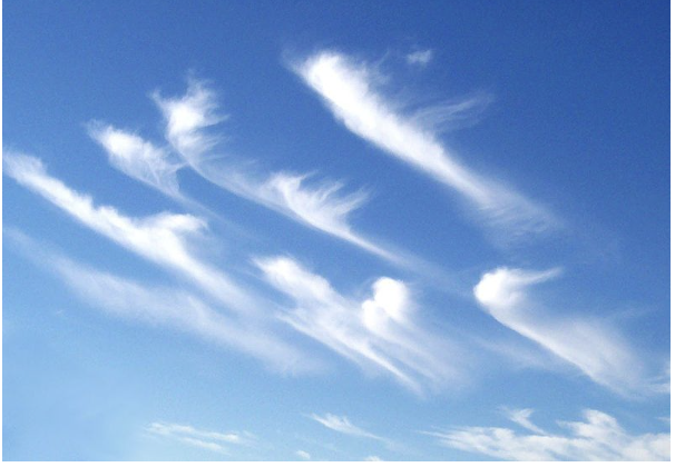
At what altitude would you expect this cloud type to be at?
20 000 ft - 40 000 ft
This cloud often signals changing weather and may grow thicker with an accompanying warm front. This type is
cirrostratus.
Composition is of water droplets that may be super-cooled and the Sun is often dimly visible through it. This type is
altostratus
The type of weather that may be approaching is
Altocumulus castellanus (ACC) is an early sign for thunderstorms and showers later throughout the day. Later, more mature signs are towering cumulus (TCU) and cumulonimbus (CB).
The correct answer is: showery precipitation.
Which is not a low level cloud?
SC
NS
AS
ST
Any cloud that has the term 'alto' in its name are mid level clouds, staring above 6 500 feet.
The correct answer is: AS
Which cloud may produce light to moderate precipitation?
NS
ST
SC
AS
NS
A cloud not of vertical development would be
TCU
CU
CB
NS
Clouds of vertical development have the term 'cumulus' in its name. Clouds of horizontal development use the term 'stratus'.
The correct answer is: NS.
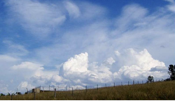
When a storm is developing the clouds may transition from
cumulus to towering cumulus to cumulonimbus.
This cloud type, pictured, is associated with what other cloud type?
Cumulonimbus
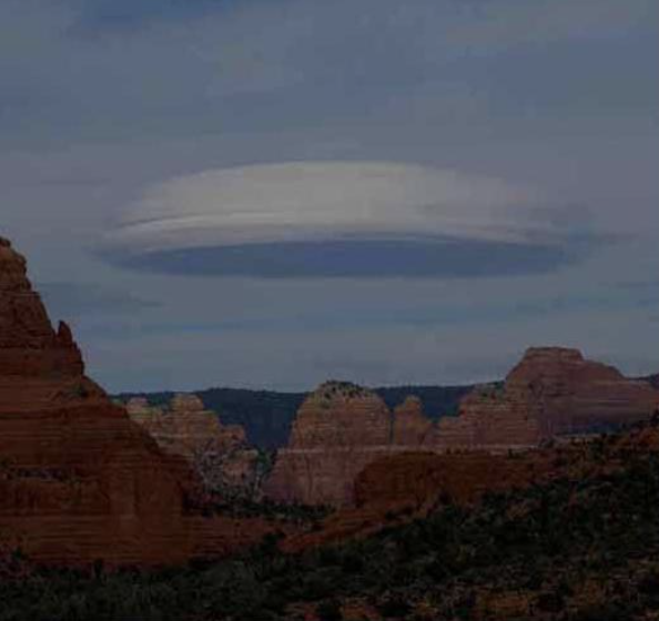
Common over mountain ranges and is associated with turbulence and strong winds. This type is a
Lenticular cloud
Which orographic cloud forms as a result of gradient winds shifting from the surface to that at altitude?
Rotor Cloud
Pressure is measured in
millibars relative to sea level.
Standard sea level pressure is
1013 millibars
When isobars are spaced close together the pressure gradient is . . . . . and will produce . . . . . winds.
steep, strong
Primarily responsible for the Coriolis force is
Earth's rotation.
When the isobars on a weather map are very close together a pilot should expect
a very strong wind.
Horizontal movement of air is known as
Advection
The Coriolis force appears to deflect air
to the right in the Northern Hemisphere.
The pressure gradient force and the Coriolis force are
working against each other in opposite directions.
Geostrophic wind moves
parallel to the isobars.
The Tricellular model places the doldrums over the
Equator
The Tricellular model predicts the weather conditions at 30° Latitude to be
clear skies and stable weather.
The Tricellular model predicts the weather conditions at 60° Latitude to be
cyclonic rainfall.
While on a cross country flying directly into wind you decide to climb up 4 000 feet higher. The course correction likely needed is a slight correction to the
With increasing altitude the effect of friction from the ground becomes less. This causes less restriction of the Coriolis force and the wind turns into geostrophic wind. Also, reduced friction causes increase in wind speed.
The correct answer is: right and the ground speed will be decreased.
A sea breeze occurs during the ___ (day/night)
day and blows towards shore.
Katabatic is wind blowing
down valleys at night.
Increased performance wind shear is
an increasing headwind or decreasing tailwind.
Decreased performance wind shear
may cause an aircraft to undershoot the runway.
causes an aircraft to sink below the glide slope during approach.
leads to a decrease in climb gradient.
The Polar Front jet stream is found
between 40° and 60° in both hemispheres.
Not a characteristic of the Sub Tropical jet stream is
it follows an east to west path.
According to Buys Ballot
with your back to the wind your right hand points to the high pressure system.
When looking at the big picture air at Earth's Poles tends to be involved in
subsidence
The resultant wind affected by friction moves
at an angle to the isobars
The Tricellular model places the doldrums over the
equator
The wind velocity characteristics of a jet stream include winds of at least
60 KT at every point along its axis.
It is not true that jet streams develop more readily when the structure of the atmosphere has
a. an abrupt change in Tropopause height.
b. strong vertical temperature gradients.
c. strong horizontal temperature gradients.
d. a frontal system.
strong vertical temperature gradients.
It is not true regarding jet streams that
the jet lies in the cool air above the frontal surface.
It is true regarding jet streams that (Where is the most severe clear air turbulence found)
the most severe clear air turbulence are usually found on the low pressure side of the jet stream axis.
While flying through a jet stream you monitor the OAT gauge and notice a rise in temperature. To avoid turbulence you choose to
climb
Jet streams are typically found between the altitude ranges of
10 000 to 30 000 feet.
Jet streams are located
just below the Tropopause.
Which jet stream is not associated with a frontal system?
Subtropical jet stream
Clear air turbulence associated with a jet stream can be anticipated when
the 30 KT isotachs are spaced closer than 90 NM on the 250 MB chart.
the horizontal temperature lapse rate is steep.
traveling on the poleward side of the jet stream axis.
Jet stream speeds are greatest during the
winter due to sharper horizontal temperature contrasts.