Humidity, Clouds & Precipitation Flashcards
1/16
There's no tags or description
Looks like no tags are added yet.
Name | Mastery | Learn | Test | Matching | Spaced |
|---|
No study sessions yet.
17 Terms
Humidity
Water vapour: Gaseous form of water, the source of precipitation
Evaporation: from oceans, lakes, rivers, soil
Transpiration: from vegetation
Humidity pt. 2
Humidity: The amount of water vapour the air contains
1. Relative humidity: The percentage of water vapour that the air can hold at a particular temperature
ex: At 25 C, 85% relative humidity means that the air is very humid, but can still hold another 15% at 25 C
Humidity pt. 3
a. If temperature cools, relative humidity would increase
b. If temperature increases, relative humidity would drop
Saturated air: Air is filled to capacity with water vapour (100% Relative Humidity)
Dew Point
The dew point is the temperature the air needs to be cooled to (at constant pressure) in order to achieve a relative humidity of 100%
At this point, the air cannot hold more water in gas form. If the air were cooled more, the water vapor would have to come out of the atmosphere in liquid form usually as fog or precipitation
Dew Point pt. 2
The higher the dew point rises, the greater the amount of moisture in the air. This directly affects how “comfortable” it will feel outside.
Precipitation
Precipitation can occur when the air cools below the dew point
Air can be cooled by coming in contact with cold landscapes
Air can also be cooled by rising
Precipitation pt. 2
Cooling by contact
1. Dew: Moist air comes in contact with a cold surface creating water droplets
2. Frost: Condensed water vapour forms solid ice
Precipitation pt. 3
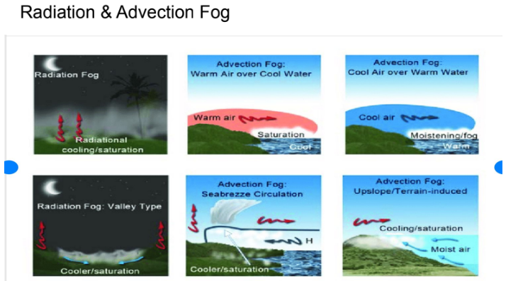
3. Fog: Cloud at ground level
a. Radiation fog: Cold air descends at night and reaches the dew point (condenses)
b. Advection fog: Warm moist air travels over a cold surface and reaches the dew point (condenses)
Cooling by rising
Air rises, cools, reaches the dew point (condenses) forms clouds and precipitationS
Ways Air is Cooled
Air is cooled by:
1. Wind rising over mountainous regions. This gives us orographic rainfall
2. Hot air rises by convection currents as the sun heats up the land. This is called convectional rainfall
Ways Air is Cooled pt. 2
Warm air rising over cold air. This occurs along moving fronts giving us frontal or cyclonic rainfall
Passing over a cold surface such as:
Cold ocean currents
Cold land surfaces
Clouds
Clouds: A mass of water droplets suspended in the air
Water vapour attaches to dust particles at the dew point and changes to miniscule water droplets (from gas to liquid)
Types of Clouds
Stratus: are relatively flat and have very little vertical development
Cumulus: are puffy clouds that may rise high into the air from the vertical movement of the air
Nimbus is related to rain clouds
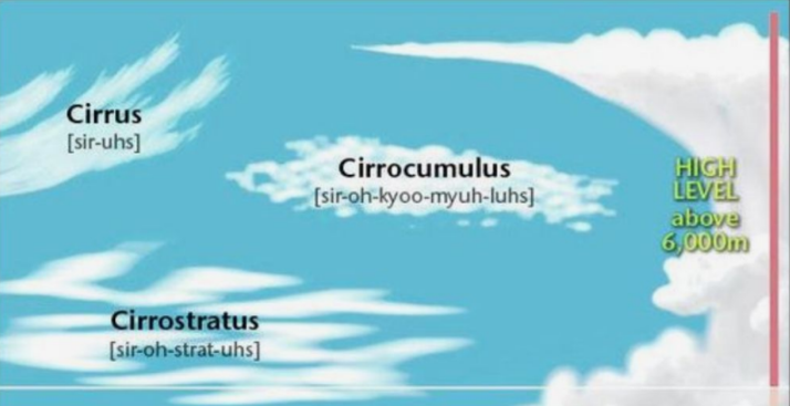
High Clouds
Above 6000 meters, made of ice crystals (begins with the prefix cirro)
A. Cirrus: High altitude wispy clouds. They are usually quite thin and often have a hairlike appearance
B. Cirrocumulus: Small puffy clouds that look like a group of cotton balls
C. Cirrostratus: A thin layer of clouds. The sky appears slightly milky than dark blue. Often has a halo around the sun
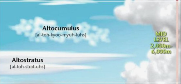
Middle Clouds
2000 - 6000 meters. Made of ice crystals at higher elevations and water droplets at lower elevations (Begin with the prefix alto)
A. Altocumulus: Fairly large puffy clouds. Can be joined like a patchwork or clouds or can appear in linear bands
B. Altostratus: A reasonably thick layer of cloud. Looks like a white sheet covering the sky. The sun cannot be directly observed, but it’s location can be seen as a bright yellow or orange glow through the clouds.
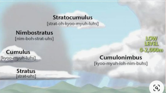
Low Clouds
Ground level to 2000 meters. Made of water droplets and have no specific prefix
A. Stratus: Usually the lowest of the low clouds. A massive sheet of dark grey covers the sky. The location of the sun is completely obscured
B. Stratocumulus: Usually from in thick bands with dark bottoms and lighter sides. Little vertical development
C. Nimbostratus: While having a low bottom, they can be very thick. They are a dark sheet of cloud associated with continuous rainfall
Clouds of Vertical Development
These cumulus clouds usually start out at a low elevation and then start to rise up as the day warms up. The hotter it gets, the higher the clouds can rise
A. Fairweather cumulus. Small puffy clouds that look like cirrocumulus clouds, except they are close to the ground on a nice, sunny day.
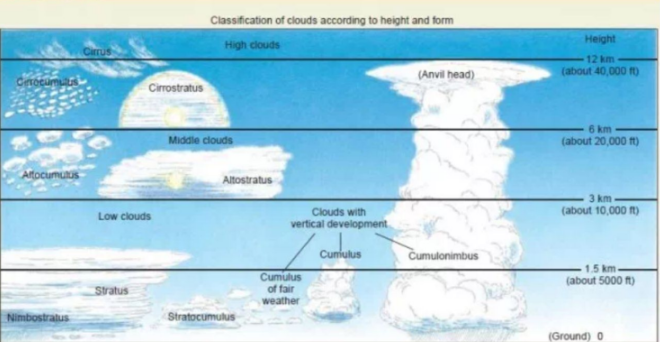
Clouds of Vertical Development pt. 2
B. Swelling cumulus. In the early afternoon as the day begins to warm, rising air will start to make the fairweather cumulus start to swell upwards into larger puffy clouds
C. Cumulonimbus. Later in the afternoon as maximum temperature is reached, the swelling cumulus continue to grow into the upper troposphere. With so much moisture, these cloids will now produce rain or hail.
