Instrument Ground Exam 2 Slideshow Study Guide
 Call Kai
 Learn
Learn Practice Test
 Spaced Repetition
 Match
Match Flashcards
 Knowt Play
1/83

There's no tags or description
Looks like no tags are added yet.
Name | Mastery | Learn | Test | Matching | Spaced | Call with Kai | Chat |
|---|
No analytics yet
Send a link to your students to track their progress
84 Terms
For taking off and landing under IFR, under part 121 or 135, what are the visibility minimums for TWO ENGINES OR LESS?
1sm visibility
For taking off and landing under IFR, under part 121 or 135, what are the visibility minimums for MORE THAN TWO ENGINES?
1/2sm visibility
For taking off and landing under IFR, under part 91, what are the visibility minimums?
Technically no federal minimum visibility requirements for takeoff. Means you can technically depart in zero-zero conditions
What is ODP?
Obstacle Departure Procedures.
What is SID?
Standard Instrument Departures
Why are instrument departure procedures necessary?
They provide obstacle clearance to departing aircraft.
What is a DP?
An Instrument departure procedure - IFR procedure published in graphic or textual format to provide obstruction clearance from the terminal area to the enroute structure.
If no departure procedure is published, what do you execute?
A standard departure
Crossing the DER (Departure End of Runway) less than or equal to 35 feet above DER elevation, climbing to 400 feet above the DER elevation before making the initial turn, and maintaining a minimum climb gradient of 200 feet/NM until the minimum IFR altitude.
What does DER stand for?
Departure End of Runway
How to calculate/fly 200 feet/NM?
FPM = Feet per NM x Groundspeed / 60
If obstacles are in the way, the procedure designer will evaluate airport and choose to:
Establish a steeper than normal climb gradient; or
Establish a steeper than normal climb gradient with an alternative that increases takeoff minimums to allow the pilot to remain clear of the obstacle(s); or
Design and publish a specific departure route; or
A combination of all the above
What are “low, close-in obstacles”?
Obstacles within 1 NM of the DER that may interfere with the standard 200 ft/NM climb, listed in Takeoff Minimums.
What are ODPs for and what do they require? (Obstacle Departure Procedures)
Designed solely for obstruction clearance to provide a departure.
Requires higher than standard takeoff minimums.
You may fly an ODP without ATC clearance, unlike SIDs
What are SIDs for and what do they do? (Standard Instrument Departures)
Still provides obstacle clearance
Reduces ATC workload
Simplifies departures, everyone flys the same procedure
What are the three types of SIDs?
Radar
RNAV
Hybrid
What is a Radar SID?
A SID that gives an initial heading and altitude, then uses ATC radar vectors to join the enroute structure. If communications are lost, follow the published lost comm procedures. The SID is the “Assigned” in AVEF.
What is a RNAV SID?
Planned routes pilots fly without radar vectors from ATC.
Can be solely pilot navigation or a combination of vectors and pilot navigation.
MUST meet RNAV 1 standards = GPS (or other suitable system) must have 1 NM accuracy 95% of the time
What is a Hybrid SID?
A SID that combines an RNAV route with radar vectors, usually from departure to the first fix
What is the difference between “Cleared via the SID” and “Climb via”?
Cleared via SID: Follow the SID’s lateral route, but get vertical instructions from ATC.
Climb via: Follow the SID’s lateral route AND published altitude/speed restrictions.
What is VCOA and what does it require?
Visual Climb Over Airport - A VMC circling climb over the airport before proceeding enroute.
Requires ATC clearance, higher weather minimums, staying within the published visibility distance, and maintaining at least 200 ft/NM to the MEA or specified altitude.
What is MVA?
Minimum vectoring altitude
Minimum altitude ATC can assign vectors to ensure proper obstacle clearance
Not published on En-route Charts
Only used for ATC
What is MIA?
Minimum IFR altitude
What is a Diverse Vector Area (DVA)?
A published area that lets ATC vector you below the MVA during departure. Requires a published climb gradient (normally 200 ft/NM) and is found in Takeoff Minimums.
When would you use a Low Altitude enroute chart?
Surface to 18,000 ft
When would you use a High Altitude enroute chart?
18,000 to 45,000 ft
What are Area Charts?
Chart that shows congested terminal areas at a large scale, IFR version of TAC charts
Symbol for VOR

Symbol for VOR/DME

Symbol for Vortac
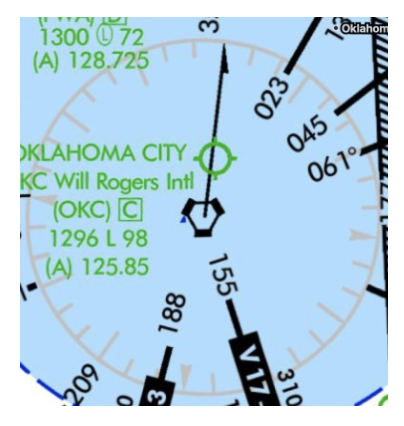
Symbol for TACAN

Symbol for NDB (Non-Directional Beacon)
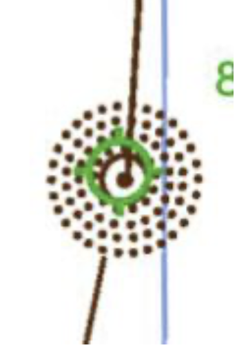
Symbol for Localizer
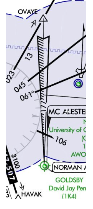
What is the altitude for Victor Airways?
1,200AGL to FL180
How wide are Victor Airways usually?
8NM wide (depends on length)
What does MEA stand for?
Minimum Enroute Altitude.
It is the lowest published altitude between fixes on an airway or route segment that guarantees acceptable navigation signal coverage and meets obstacle clearance requirements.
What does MOCA stand for?
Minimum Obstruction Clearance Altitude
It is the lowest published altitude in effect between fixes on VOR airways, off-airway routes, or route segments that meets obstacle clearance requirements for the entire route segment
Acceptable navigational signal coverage only within 22 NM of a VOR
What is a MEA gap?
A marked segment on an IFR Enroute Low Altitude Chart where ground-based navigational signal coverage is temporarily lost, even though the published Minimum Enroute Altitude (MEA) still provides safe terrain and obstacle clearance
What does MCA stand for?
Minimum Crossing Altitude
It is the lowest altitude at certain fixes where an aircraft must cross while climbing to a higher MEA.
What does MRA stand for?
Minimum Reception Altitude
It is the minimum altitude where you can reliably receive navigation signals from off-route ground stations (like VORs) to identify a specific intersection or fix.
What happens if the MRA at the fix is higher than the MEA?
An MRA is established for the fix and is the lowest altitude at which an intersection can be determined.

What does MAA stand for?
Maximum Authorized Altitude
It is the maximum usable altitude or flight level for an airspace structure or route segment. It ensures that you can receive navigation signal reception and also prevents interference with other airspace structures.
What does MTA stand for?
Minimum Turning Altitude
Minimum altitude to ensure navaid reception / vertical and lateral obstacle clearance during a turn over a specific fix, NAVAID, or waypoint.
What does OROCA stand for?
Off-Route Obstruction Clearance Altitude
- To be used in an emergency situation
- Obstruction clearance with a 1,000-foot buffer in non-mountainous terrain areas, and a 2,000-foot buffer in designated mountainous areas
- Doesn't guarantee signal coverage
What is a Changeover Point? (COP)
The point where a frequency change is necessary to receive course guidance from the facility ahead of the aircraft.
It is blocked by terrain/obstacles
Symbol for Unusable Route Segment

What obstacle protection does the primary airway area provide?
Plus or minus 4.5° from each NAVAID, providing 1,000 ft obstacle clearance in non-mountainous areas and 2,000 ft in mountainous areas.

What obstacle protection does the secondary airway area provide, and when is it used?
Used when NAVAIDs are more than 51 NM apart, protection expands to ±6.7°, adding 2 NM on each side of the airway.
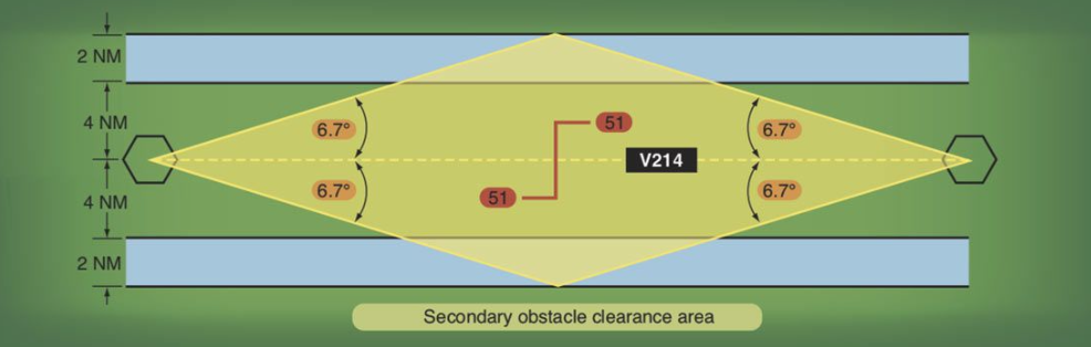
When does an obstacle protection flare occur on a Victor Airway?
When NAVAIDs are over 102 NM apart with the COP in the middle, causing protection to extend beyond the normal 8NM and 12NM airway width.

What are Jet Routes?
High-altitude routes from FL180–FL450, based on ground NAVAIDs, that act like Victor Airways for high-speed jet traffic.
What are Tango (T) Routes?
Low-altitude RNAV/GPS routes that require RNAV equipment, allow more direct IFR routing around/through busy airspace, and can have lower MEAs because they don’t rely on ground NAVAID signals.
What are Q-Routes?
High-altitude RNAV routes from FL180–FL450, used for long-range flights. They use RNP, can be closely spaced, and are found on high-altitude charts.
What are Random RNAV Routes?
Direct RNAV/GPS routes between waypoints, fixes, or airports, approved by ATC in a radar environment. Navigation is the pilot’s responsibility.
On a chart, if an airport is GREEN, what does that mean?
The airport has at least one instrument approach procedure
On a chart, if an airport is BLUE, what does that mean?
Airport has an approved instrument approach procedure published by the DOD (Department of Defense).
On a chart, if an airport is BROWN, what does that mean?
No instrument approach procedure
How is a class BRAVO depicted on a chart?

How is a class CHARLIE depicted on a chart?

How is a class DELTA depicted on a chart?
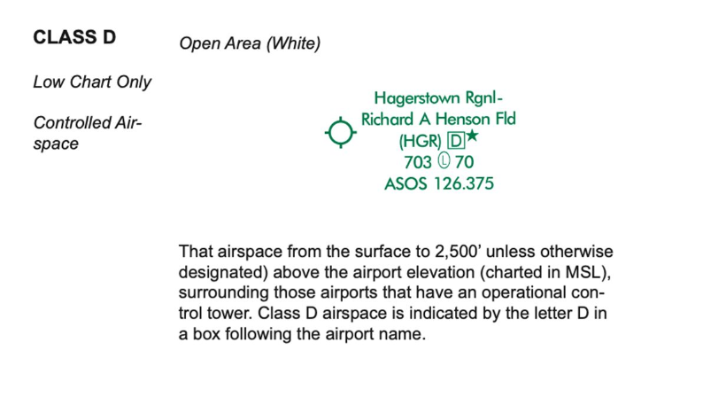
How is a class ECHO depicted on a chart?
Open area (white)
How is a class GOLF depicted on a chart?

How does Special Use Airspace affect IFR flights?
An IFR clearance clears you through Special Use Airspace. If it’s active and unavailable, ATC will reroute you around it. Remember MCPRAWN for the types of special use airspace/
What is Reduced Vertical Separation Minimums (RVSM)
A set of rules that allows aircraft to fly closer together in certain airspace
RVSM increases airspace capacity and allows aircraft to fly more efficiently
How it works
● RVSM reduces the vertical separation between aircraft from 2,000 ft to 1,000
● RVSM applies to airspace between flight levels 290 and 410
● RVSM allows aircraft to fly more fuel-efficient flight levels
● RVSM provides ATC flexibility and reduces controller workload
When must you report compulsory reporting points?
When radar contact is lost or radar service is terminated, report your position to ATC over designated compulsory VORs/intersections.
What reports are required in a non-radar environment?
Report leaving the FAF, leaving the outer marker, compulsory reporting points, and any ETA change of ±2 minutes or more.
What does M stand for in MARVELOUSVFRC500
Missed Approach
What does A stand for in MARVELOUSVFRC500
Airspeed plus/minus 10KTS or 5% change of filed TAS (Whichever is greater)
What does R stand for in MARVELOUSVFRC500
Reaching a Holding Fix (Report time and altitude)
What does V stand for in MARVELOUSVFRC500
VFR on top when an altitude change will be made
What does E stand for in MARVELOUSVFRC500
ETA change plus/minus 2 minutes
What does L stand for in MARVELOUSVFRC500
Leaving a holding fix/point
What does O stand for in MARVELOUSVFRC500
Outermarker (Or fix used in lieu of it)
What does U stand for in MARVELOUSVFRC500
Unforecasted weather
What does S stand for in MARVELOUSVFRC500
Safety of flight (Any other information related to safety of flight)
What does the second V stand for in MARVELOUSVFRC500
Vacating an altitude / FL
What does F stand for in MARVELOUSVFRC500
Final Approach Fix
What does the second R stand for in MARVELOUSVFRC500
Radio/Nav/Approach equipment failures
What does C stand for in MARVELOUSVFRC500
Compulsory reporting points
What does the 500 stand for in MARVELOUSVFRC500
Unable climb/descent 500 FPM
GRABCARD
Generator/alternator
Radios
Altimeter w/Kollsman window
Ball 😊
Clock with sweeping second hand
Attitude indicator
Rate of turn indicator
Directional gyro
DME (above FL240)
Two way radio comm failure in IFR, what do you do?
AVEF (In order)
A - Assigned route
V - Vectored (fly to fix/route/airway last vectored to)
E - Last expected route by ATC
F - Filed route
MEA (Alt highest)
M - Minimum altitude prescribed for IFR
E - Expected (as in: “Expect 5000 10 min after departure)
A - Assigned. Last altitude assigned by ATC
What does it mean if ATC says: “Descend at pilot’s discretion”
It allows a pilot to determine one’s own optimum descent rate
What does “Descend and Maintain” mean?
Begin descending immediately at an optimum rate to the assigned altitude, then maintain it.
What does “Descend Via” mean?
Follow the STAR’s published route, altitude, and speed restrictions.
What is a Hold?