module 2 paleontology
1/83
There's no tags or description
Looks like no tags are added yet.
Name | Mastery | Learn | Test | Matching | Spaced |
|---|
No study sessions yet.
84 Terms
Principle of superposition
In any undisturbed succession of strata, oldest strata are at the bottom with successively younger ones above. A layer of rock is always older than the layer above it, unless they have been
turned upside down.
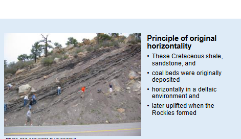
Principle of original horizontality
-Particles which settle under the influence of gravity settle to more nearly horizontal layers.
-Generally sediments deposited on land or in the sea form nearly horizontal layers.
-In some cases, they are inclined, as on the sloping face of a sand dune, but parallel to the surface of deposition. In most cases, if an area has strongly inclined or dipping sedimentary rocks, they were disturbed by forces from their original horizontal attitude.
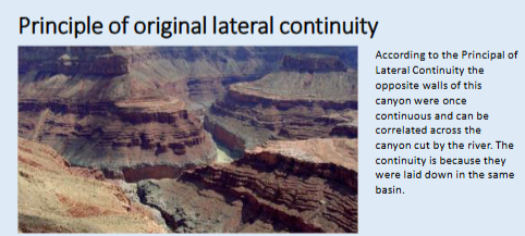
Principle of original lateral continuity
• Strata extend in all directions until they thin against the edges of the basins in which they have accumulated.
• The original continuity of strata in a basin can be broken or faulted. For example, a river can carve a canyon into a basin filled with sediment leaving once-continuous layers stranded on opposite sides of the canyon. According to the principle of original lateral continuity, these opposite sides of the valley were once laterally continuous.
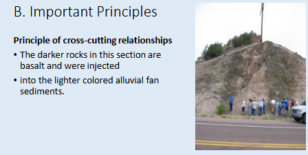
Principle of cross-cutting relationships
-Disturbed rocks or strata (a distinct layer of rock or sediment visually separable from adjacent layers) are older than those rocks that disturb them or cut through them.
-For example, magma can be forced or intruded into preexisting rocks from their sources below. After these intrusions cool, they form igneous rock that cuts across the other rock. Obviously the intrusive igneous rock is younger than the rock into which it cuts. Faults also cut through rocks and those rocks are older than the fault that cuts through them. The age of faults can often be determined by establishing the age of unfaulted strata overlying faulted strata because the unfaulted strata was deposited after the faulted rocks it buried
Principle of fossil succession
In a succession of strata, fossil species succeed one another in a definite and recognizable order. This order of appearances and disappearances is largely the consequence of organic evolution, of the appearance of new species and the extinction of others
Principle of fossil assemblages
Like assemblages of fossils are of similar age. Since the sequence of fossil species found in the rock record is similar everywhere, similar assemblages should be of similar age and correlated to one another
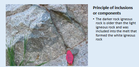
Principle of inclusions or components
A body of rock is younger than another body of rock from which any of its components are derived. This means if a fragment of one body of rock is eroded or otherwise incorporated into a second body of rock, the second is younger than the parent of the fragment.
Principle of inclusions or components
The darker rock igneous rock is older than the light igneous rock and was included into the melt that formed the white igneous rock
Relative Geologic Time
Until the second half of the twentieth century, the geologic time scale was a relative one. That is, ages of rocks were based upon the relative position (above or below) to one another and not absolute age in millions of years.
Radiometric age dating, the basis of establishing the absolute geologic time scale, was not possible until significantly after the discovery of radioactivity in 1896 and the availability of equipment capable of measuring the ratios of radiogenic isotopes.
The relative geologic time scale began to grow during the nineteenth century when the geologic periods were first defined as specific intervals of time. These intervals were called periods and the rocks of these periods belong to systems. For example, the Ordovician Period is an interval of time during which rocks of the Ordovician System Were deposited
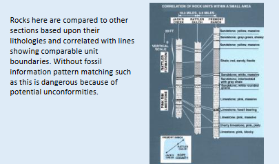
Rock correlation
The relative geologic time scale is a composite representation of the geologic record of numerous sites. Because of the removal of strata by erosion, periods during which sediments are not deposited, sparseness of sedimentary rock exposure, and other factors, the sedimentary record in any area only contains a small portion of the geologic record. As a consequence, a relative geologic time Scale requires a composite of geologic sections of different ages from a variety of
localities
Chronostratigraphic and Geochronstratigraphic Units
• The purpose of such a classification is "to organize systematically the Earth's sequence of rock strata into named units (chronostratigraphic units), corresponding to intervals of geologic time (geochronologic units), so that these may facilitate time-correlation and age determination of strata and serve as a reference system for recording events of geologic history."
• For each chronostratigraphic unit-term (rock strata) there is a corresponding geochronologic unit-term (interval of geologic time).
Chronostratigraphic and Geochronstratigraphic Units
e.g. All rocks of the Devonian System are buried by surface rocks in the State of Florida (usage here refers to rocks so the chronstratigraphic term “System” is used).
e.g. During the Cretaceous Period, dinosaurs ruled the vertebrate world (usage here refers to time so the geochronologic term “Period” is used).

Chronostratigraphic and Geochronstratigraphic Units
• The relative geologic time scale is divided into three large-scale divisions, the Archean Eon, Proterozoic Eon, and the Phanerozoic Eon.
• This course is only concerned with a portion of the last of these eons, the Phanerozoic Eon.
• The Phanerozoic Eon represents that portion of the geologic record containing abundant fossil invertebrates with skeletonized hard parts
Phanerozoic Eon
-The Phanerozoic Eon was the first eon to be further subdivided into smaller divisions based upon the record of fossils found within it. The two older eons contain fossils but they are rare, generally microscopic and were not even discovered until the twentieth century.
-The Phanerozoic is divided into three primary intervals, or eras, which the fossil record defines. The oldest is the Paleozoic Era (meaning "interval of old life"), followed by the Mesozoic Era (meaning "interval of middle life"), and the youngest Cenozoic Era (meaning "interval of modern life"). These three eras are divided by the two greatest extinctions in Earth history. The middle of these three eras, the Mesozoic Era, and the extinction that marks its end are subjects of this course.
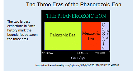
eras
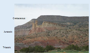
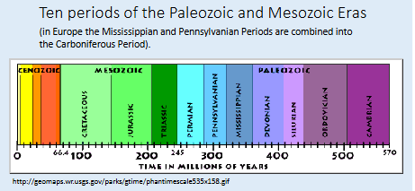
Each era is in turn divided into periods, The Mesozoic Era has three periods, from oldest to youngest these are the Triassic, Jurassic, and Cretaceous Periods.
There are even smaller divisions of periods, called stages, but herein we will divide these periods into Early (oldest), Middle, and Late (youngest).
Ten periods of the Paleozoic and Mesozoic Eras
In geology we have both rock and time stratigraphic terms, used
according to context.
• If you are speaking of an interval of time you should use the time
stratigraphic term (e.g., Triassic Period).
• If you are referring to rocks of the Triassic you use the rock
stratigraphic equivalent of a period, the system (e.g., These are rocks
of the Triassic System). From oldest to youngest, the rock stratigraphic
equivalent of Early, Middle, and Late are Lower, Middle and Upper.
Importance of the Formation
• In the field of biology and paleontology, scientists use a system of nomenclature to define and refer to the diverse past and present life non the planet. This single system avoids confusion among scientists because it allows only one accepted name for a species.
• Geologists have a similar system of referring to distinctive groups of rocks called formations, thus allowing a uniform means of referring to a specific group of rocks. The formation is the basic rock unit defined on the basis of distinctive and easily recognizable characteristics found throughout its occurrence.
• All new formations have a designated type locality where it is well exposed and most typical in its characteristics. Usually formations are given a geographic name after the location of the type locality. For example, the Upper Jurassic Morrison Formation is named after Morrison, Colorado. Once defined in a type section, its distribution can be mapped and its environment of deposition interpreted. It is the smallest mapable unit
main characteristics used to define a formation
The main characteristics used to define a formation are listed below. The sum of these characteristics define the rocks' lithology (after lithos, meaning "rock"):
• composition of mineral grains,
• color,
• lithology, including petrography, mineralogy, geochemistry
• lateral variation
• Relation to adjacent units and nature of boundaries,
• character of organic remains,
• texture (size of grains, etc.),
• thickness and geometry of stratification,
• outcrop character
• Location of type section
The formation is not the only lithostratigraphic unit but it is the fundamental unit. Lithostratigraphic units are defined in a hierarchical framework:
1. Supergroup- generally includes contiguous groups and may contain formations not assigned to a
group.
2. Group- groups are commonly defined by basin-wide unconformities and their correlative
conformities.
3. Formation- see previous figure
4. Member- A subdivision of a formation, often near the geographic margin of the formation.
Formations need not include members or beds.
5. Bed- Beds are named (e.g. Baker Coal Bed) and have some lateral continuity and distinctiveness
within a formation
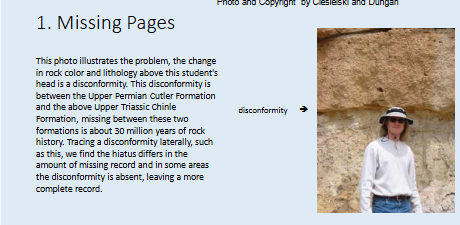
Missing Pages
Sometimes a complete geologic record is missing in a specific region and the missing record of that interval of geologic time must be searched for elsewhere.
A horizon between rocks or sediments with distinctly different ages is a hiatus or unconformity. This unconformity boundary is defined as missing a portion of the geologic record. Across a hiatus, sediments or rocks can vary in age by millions or hundreds of millions of years.
Causes of unconformities
Unconformities have many causes. One cause might be non-deposition,
simply that no sediment was deposited. A common cause is erosion. If
erosion is brief, the amount of sediment or rock removed may be small.
Erosion often follows mountain building in a region. Persistent and deep erosion (e.g., by glaciers) can remove hundreds of feet of rock and millions of years of geologic history
unconformities
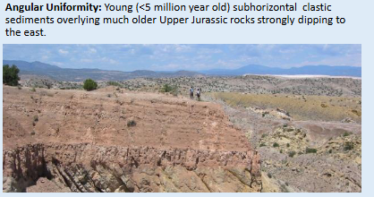
• There are three types of unconformities.
• The most difficult to detect is the disconformity where there is no lack of parallelism in the strata above and below the hiatus.
Angular Uniformity:
• An angular unconformity exhibits a discordance between the angle of the beds across the hiatus, usually tilted beds separated from flat- lying beds. Beds of the older strata (below) dip at a different angle (usually steeper) than the younger strata overlying them.
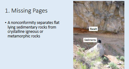
nonconformity
• A nonconformity separates flat-lying sedimentary rocks from crystalline igneous or metamorphic rocks
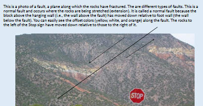
Deformation
• Deformation is the process of deforming rocks.
• Stress fields of continents change over time, often in response to plate tectonic forces. Regions that were once stable can come into a compressive stress field which can cause folding, faulting, and thrusting of once horizontal rocks.
• When sedimentary rocks are deformed in this way, care must be taken in the interpretation of the geologic history, especially if they are partially concealed and difficult to see. Here are a few examples of deformation structures.
Toward an Absolute Geologic Time Scale
• By the careful analysis of stratigraphic sections and their fossil contentngeologists slowing built the relative geologic time scale.
• The absolute geologic time scale (next unit of this module) was constructed by determining absolute ages of horizons in important stratigraphic sections (e.g. type sections) to allow assignment of absolute ages to boundaries.
• Absolute age dating only became possible in the later half of the twentieth century thus the absolute geologic time scale is relatively new and frequently revised based on new information
Types of biostratigraphic zones. Assemblage zone
A body of rock or strata whose content of fossils, or fossils of a certain kind, taken in its entirety, constitutes a natural assemblage or association which distinguishes it in biostratigraphic character from adjacent strata."
Taxon-range-zone
Taxon-range-zone - A body of rock or strata "representing the total
range of occurrence (horizontal and vertical) of specimens of the taxon
(species, genus, family)."
Concurrent-range-zone
Concurrent-range-zone - A body of rock or strata "defined by those
parts of the ranges of two or more selected taxa which are concurrent
or coincident." Also known as an overlap or range overlap zone.
Lineage-zone
Lineage-zone - A body of rock or strata "containing specimens of a
bioseries representing the evolutionary or developmental line of trend
of a taxon or biologic group, any segment of such, defined above and
below by features of the line or trend
Acme-zone
Acme-zone - A body of rock or strata "representing the acme or
maximum development of some taxon but not its total range."
Interval-zone
Interval-zone- A body of rock or strata " between two distinctive
biohorizons but does not itself represent any distinctive range or even
any particularly distinctive biostratigraphic assemblage.
Barren interzone.
Barren interzone- A body of rock or strata " lacking in fossils between
adjacent biozones may be referred to as barren interzones and referred
to informally by reference to adjacent zones.
Barren intrazone
Barren intrazone- A barren interval within biozones
Magnetostratigraphic Concepts
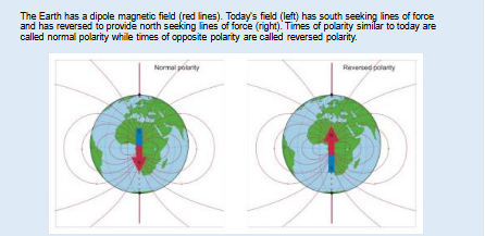
1. Magnetic field of the Earth and magnetic reversals.
• Currents in the liquid outer core produce the Earth's dipole magnetic field.
• Periodically the orientation of the Earth's magnetic field reverses.
• Today's magnetic field has south-seeking magnetic lines of force at the North magnetic pole.
• Intervals in the past with the same orientation as today are called normal polarity intervals; whereas, intervals the opposite of today are called reversed
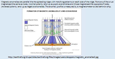
Magnetic anomalies of the ocean crust and the magnetic anomaly time scale
• New ocean crust is formed at ocean ridges (e.g. Mid-Atlantic Ridge).
• As new ocean crust cools, it acquires a signature of the magnetic field at the time it forms (normal or reversed).
• Additional crust forming at the ridge spreads the former crust away from the ridge (sea floor spreading).
• Over time, parallel strips of normally or reversed magnetized crust are formed as the ocean widens.
• These strips are recorded as magnetic anomalies.
• Positive anomalies are normally magnetized and negative anomalies are reversed magnetized.
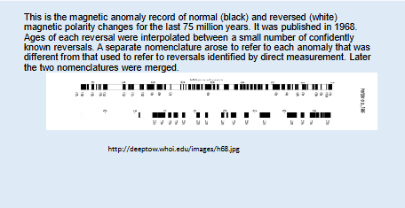
The Magnetic Anomaly Time Scale
A composite record of these anomalies has been constructed for the Cenozoic (0-66m.y.), Cretaceous and portions of the Jurassic. Interpolation of the ages of all anomalies was constructed by interpolation between the ages of a few well known anomalies to produce the Magnetic Anomaly Time Scale.
• This time scale was a more lengthy (older record) one than could be obtained by direct measurements of volcanic and sedimentary rocks until new technology in the 1980s allowed direct measurement of reversals from sedimentary rocks
Magnetic Reversals in Volcanic Rocks and Sediments
• Cooling continental volcanic rocks and sediments accumulating in the ocean acquire a remnant magnetism of the magnetic field that can produce a reversal chronology.
• Combined with radiometric dating this chronology began to produce a paleomagnetic time scale, independent of the magnetic anomaly time scale
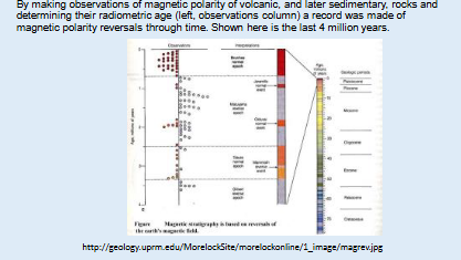
Paleomagnetic Time Scale
• Young portions of the paleomagnetic time scale were generated from the study of volcanic rocks (Late Miocene-Recent)
• older portions were pieced together from the study of long continuously recovered sediments taken by non-disturbance coring techniques by the Ocean Drilling Program.
• These efforts produced a Paleomagnetic Time Scale.
• Finally the magnetic anomaly time scale and paleomagnetic time scale were merged with a unified nomenclature.
Integration of the magnetic anomaly and paleomagnetic time scales
• Both the magnetic anomaly time scale and paleomagnetic time scales were generated
somewhat independently with different terminology for reversals.
• Recently these time scale have been merged to produce a geomagnetic time scale.
• Long duration reversals are called Chrons.
• Short duration reversals are called Subchrons.
• Youngest Chrons are named: Brunhes, Matuyama, Gauss, and Gilbert
• Youngest Subchons are also named: Jaramillo, Olduvai, Kaena, Mammoth, etc.
• Older (>~5 m.y.) reversal Chrons are numbered.
• Studies of fossils in paleomagnetically calibrated sections has produced a means of identifying individual reversals.
• Reversal ages have been interpolated between radiometrically dated calibration points.
Limitations of the paleomagnetic time scale
• There are only two types of reversals, normal and reversed.
• Disconformities may superimpose two separate normal or reversed polarity intervals, making them appear as a single reversal.
• Disconformities, if undetected, may result in an incorrect interpretation of the vertical sequence of reversals.
• Identifying individual reversals requires preexisting correlation of biostratigraphic data to individual reversals, thus providing a biologic fingerprint to differentiate them from other reversals
Chemical changes in the ocean can be used as stratigraphic tools if:
Chemical changes in the ocean can be used as stratigraphic tools if:
1. Those chemical changes occur globally,
2. Do not repeat in their abundance characteristics frequently,
3. Can be measured in sedimentary sequences with fossils.
Strontium isotope stratigraphy
• Two isotopes of strontium (Sr-86 and Sr-87) generally occur with the same relative abundance throughout the oceans because the mixing time in the oceans is about 1000 years or less.
• “Heavy” strontium (Sr-87) is weathered from continental rocks and delivered into the ocean by rivers as dissolved load. “Light” strontium (Sr-86) is delivered by seafloor hydrothermal systems. Today oceanic mixing provides a uniform ratio of .79073.
• The ratio of these isotopes has changed through time, partly with changes in rates rocks yield strontium to the ocean by exposure and erosion. Increases in continental weathering (increased mountain building or increased glacial erosion, for instance) would shift the 87Sr/86Sr ratio higher, and an increase in hydrothermal processes (by increased sea-floor spreading) would shift ratios lower.
• Changes of the ratios of these isotopes through time have been dated for the Cenozoic
• The abundance of Sr-87 has increased relative to Sr-86 due to increased continental denudation
• Variations in isotopic compositions of sediments or fossils allow
eochemists to construct isotopic composition curves that can be used as stratigraphic markers for correlation purposes.
• The rate of change is uneven with periods of little change and other intervals with more rapid change.
• Periods of rapid change offer a means of dating sediment by determining the Sr ratios within the shells of calcareous fossils.
• The technique is usually confined to dating samples that only have shell
fragments where the sample cannot be dated by fossil biostratigraphy.
• Analytical error and rate of strontium isotope change in the ocean usually restrict age dates to plus or minus 1or 2 million years.
• Dates are inaccurate if the fossil are diagentically altered.

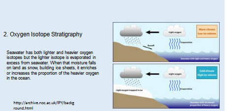
Oxygen Isotope Stratigraphy
• Isotopes (species of an an element with different atomic mass) of oxygen- 16 and oxygen-18 occur in seawater (H2O).
• Although water temperature and salinity influence the ratios of these isotopes, the primary control on the global ratio of these isotopes in seawater has been large scale fluctuations in Northern Hemisphere ice volume.
• During the process of evaporation the lighter isotope (O-16) is preferentially taken up over O-18. Precipitation of this O-18 enriched water on continents, in the form of snow, occurs in huge amounts to form ice sheets. This process changes the oxygen isotopic composition of the oceans. If these changes can be dated they can provide a means of high resolution stratigraphy.
. Oxygen Isotope Stratigraphy
Seawater has both lighter and heavier oxygen isotopes but the lighter isotope is evaporated in excess from seawater. When that moisture falls on land as snow, building ice sheets, it enriches or increases the proportion of the heavier oxygen in the ocean.
Orbital Pacemaker to the Ice Ages"
This discovery of matching frequencies of climate with the Milankovitch orbital cycles, led to publication in the late 1960s of the theory "Orbital Pacemaker to the Ice Ages". Yes, glacial-interglacial variations appear to be related to changes in these parameters : MILANKOVITCH CYCLES
Oxygen Isotope Stratigraphy
• An initial study of the record of oxygen isotopic variations over the last million years revealed some 19 major shifts between glacial/interglacial variations.
• The detailed record of glacial-interglacial variations, from oxygen isotopes of fossil planktonic foraminifera, revealed important cycles of climate change with frequencies of 400,000, 100,000, 41,000, and 23,000 years.
• Additional insight became evident with the discovery that these climate frequencies corresponded to changes in orbital parameters of the Earth as noted by the Yugoslavian scientist Milankovitch
Oxygen Isotope Stratigraphy
• As incredible as it seems, the climate frequencies in the oxygen isotope signal matched that of the Milankovitch orbital parameters.
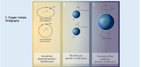
• These orbital parameters (next figure) are driving changes between glacial and interglacial conditions in the Northern Hemisphere
These orbital parameters (next figure) are driving changes between glacial and
interglacial conditions in the Northern Hemisphere.
• 1. Axial Tilt (period = 41,000 yr.) 21.5-24.5o range tilt shallow=greater polar snow because less summer melt
• 2. Eccentricity of Earth orbit (period= 400,000 & 100,000 yr.) 0.017- 0.053 eccentricity, greater eccentricity= colder
• 3. Precession of the Equinoxes Wobble of the axis (period=23,000 yrs.) causes the position of the equinoxes and solstices to shift in position around the Earth's elliptical orbit
The record and age of oxygen isotope changes in the ocean
• 116 major cycles (oxygen isotope stages) of O-18 enrichment or depletion have been documented in the sedimentary record of the last 2.8 M.Y.
• These stages represent glaciations and interglacial events.
• Since the frequency of these glacial-interglacial variations matches the Milankovitch factors, the ages of stage boundaries can be orbitally tuned to provide absolute ages.
• In high sedimentation depositional environments this allows a determination of sediment age to within hundreds of years.
• Today's interglacial is stage 1, all interglacials are odd numbered
• The last glacial is stage 2, all glacials are even numbered
• there are 116 stages over the last 2.8 M.Y.
• Calibration of biostratigraphic data to oxygen isotopic stages allows them to be used in subsequent sections as high resolution age datums.
• Since the glacial/interglacial stages vary with the orbital parameters, their ages can be tuned to the orbital record. This tuning provides highly accurate absolute ages.
• Fossil occurrences can be correlated to the oxygen isotope stages to provide high resolution ages to the fossil datums.
Biologic species concept
The concept of species is critical to biology and paleontology, although the concept is very different between the two.
• The species is the fundamental unit of taxonomy.
• The biological definition of species: A biological species is a “group of interbreeding natural populations that are reproductively isolated from other such groups (Mayr, 1966)”.
• The breeding habits of most populations and their variability are poorly known. About one sixth of species are properly defined on this basis.
• For the other five-sixths of species, the basis of determining whether or not specimens are conspecific with another is based upon the known inferred range of intraspecific variability based on study of comparative material.
The paleontological species concept
• The fossil record offers no insight into the parameters of breeding populations.
• Instead differentiation of taxa is based upon morphologic characteristics of population.
• Ideally characteristic are chosen expressing evidence of phylogenetic affinities and reflection on the nearness of descent.
• Any species has a spread of morphologic variation that can be expressed in a geographic and stratigraphic manner. Documentation of this variability is important to a valid species concept
Modern ideas about evolution.
1. Anagenesis and sympatric speciation.
• Anagenesis is the Darwinian view of evolution was one of slow, gradual change of a lineage of taxa through numerous stages in a relatively stable environment.
• A type of speciation associated with anagenesis is sympatric speciation where favorable mutations spread through the gene pool with the help of natural selection until it is reproductively isolated
Cladogenesis and allopatric speciation
• In another process, cladogenesis, a new branch in a lineage is created by small communities of the species that are isolated on the margin of its geographic range. This type of speciation is allopatric speciation.
• Both sympatric speciation and allopatric speciation are representative of phyletic gradualism, requiring a full range of intermediate forms between successive species.
Punctuated equilibrium
• In 1972 a new evolutionary idea was put forth called punctuated equilibrium. The argument was that most groups evolve in short, rapid spurts (punctuations) followed by long intervals of stasis or little change.
• Fossil evidence seems to support sudden appearances of new species.
• The proponents, Elderidge and Gould, suggested allopatric speciation of small communities that were isolated by geography or ecology on the periphery of the taxon range.
• Speciation on the range periphery meant little chance of preservation of the isolated nucleus of a new species. When they became more widespread their appearance would appear abrupt and record punctuated.
• So which is it?...punctuated equilibrium or phyletic gradualism. There are examples of both. From my own research I have documented very detailed examples of gradualism. Both speciation methods appear to be at work
Why taxonomy?
• A common nomenclature provides a single means of identifying things in a common language that all can understand. It is for this reason that we have a common stratigraphic nomenclature, as previously noted.
• Taxonomy provides a hierarchical classification system for all forms of life
Classification and Nomenclature
• Taxonomy is the classification and nomenclature of organisms. The naming of animals and plants is conducted according to the respective guidelines or codes known as the International Rules of Zoological Nomenclature by the International Committee on Zoological Nomenclature and the International Rules of Botanical Nomenclature by the International Committee on Botanical Nomenclature. Problems or disagreements on interpretation of these codes are ruled on by governing committees.
• All living and fossil organisms are named according to a binomial system of Latin or Latinized words. This taxonomic system dates to the tenth edition of Systema Naturae by Carolus Linnaeus (1758)
International Code of Zoological Nomenclature
• A distinct set of rules, The International Code of Zoological Nomenclature, has been established to govern the naming of animals. These rules address such things as:
• spelling of names. Names must have Latin endings and most have Greek or Latin roots,
• establishing the priority of names,
• what constitutes a valid description,
• establishment of type specimens and type localities, and
• permanent curation of type specimens.
species
• The fundamental unit in taxonomy is the species. Species can be united into a common genus (genera is plural), genera into families, families into orders, orders into classes, and classes into phyla (singular is phylum).
• There are sometimes subdivisions of these hierarchical units (e.g. subphylum, subclass, etc.).
• There are about 30 phyla in the Animal Kingdom but fewer than half have a fossil record
Classification and Phylogeny
• The traditional hierarchical classification of fossils is based on morphological
(phenetic) resemblance. Phylogenetic relationships, the manner of relationship
and the recentness of common ancestors play an important role. Determining
relationships depended very much on the order of succession in the fossil record,
along with geographic distribution.
• Paleontologic classification, particularly invertebrate paleontology, has been very
stratophenetic, time as defined by stratigraphic placement a very important
consideration in determining descendant relationships
Cladistic analysis
• Cladistic analysis is a relatively new technique for reconstructing phylogeny.
• Cladistic analysis is well-suited to determine phylogeny because they produce
cladograms or hierarchical branching diagrams depicting shared morphology.
• The technique determines how closely related organisms are by the degree to
which they share specific features. As you would expect, closely related
organisms tend to share unique features or evolutionary novelties which are
more recently derived than ancestral novelties which have a more ancient history.
• Taxa sharing the most evolutionary novelties are shown in the cladogram as diverging from a common ancestor.
cladistic method
• The cladistic method produces a cladogram based only on similarities of taxa and
does not include time or geologic range information, avoiding the problems of
the stratophenetic approach to phylogeny.
• Each branch or bundle of branches with a common stem comprises a clade or
monophyletic group.
• Cladistic analysis of fossil invertebrates is far from adequate for a cladistic
classification of invertebrate phyla, consequently the more traditional method of
evaluating phylogenetic relationship is employed herein
Describing the species
The species name.
• e.g. Nitzschia weaveri Ciesielski
• The first name is generic, the second trivial, followed by the author of the
species.
• The genus name is capitalized but the trivial name is not.
• Both names are underlined in writing and italicized in print
What is in a good fossil species description
• A description of the physical characteristics.
• Measurements of important morphologic characteristics.
• Photos or line drawings.
• A description of how it differs from closely related taxa.
• A discussion of intraspecific variability.
• Information about its stratigraphic and geographic range.
• A designation of a type(s) specimens
• Deposition of the types in a responsible depository (museum).
• Designation of a type section.
• Publish in a peer reviewed journal or book.
Some Important Type Terms
All taxonomic units must have a type specimen designated. For example:
A Family must have a type genus:
• a. Type-genus: The genus upon which a family is based. Family names are formed
by adding idae to the stem of the generic name.
A genus must have a type species:
• b. Genotype: The single species upon which the genus is based
Types of Specific Categories
a. Holotype: the single specimen taken as the "type" by the author of the species
• b. Syntype: one of several specimens of equal rank upon which a species is based
• c. Paratypes: other specimens used as examples of the type
• d. Hypotype: a described, figured, or listed specimen from the type collection
• e. Topotype: a specimen from the type locality of a species
• f. Lectotype: "the type" specimen designated by a subsequent worker from the
previously designated syntypes.
• g. Neotype: "the type" specimen selected as the type subsequent to the original
description in cases where the original types have been described or were
declared invalid by the Commission
Taxonomic Name Endings
• If the trivial name is an adjective it must agree in gender with the generic name.
us (masc.)
a (fem.)
um (neuter)
is (m. and f.)
e (neuter)
• Geographic names end in ensis and ense
• Species named in honor of a person end in i (man) or ae (woman)
The Synonymy
The Synonymy
• A synonymy is an arranged chronology of the taxonomic history of a taxon.
• It includes all published scientific names by which the species has been
designated.
• Citings are given in chronological order with bibliographic references after each
name.
• Generic and specific names are followed by the author of the species.
• The author's name is in parentheses if the species is transferred to another
genus.
• It cites the original description of the species and often gives reference to
modern descriptions with photos when the original description is difficult to find.
• The synonymy occurs at the end of a scholarly publication and cites all taxa
mentioned in the article.
Synonymy examples
Examples:
Original species name intact:
Family Spongodiscidae (Haeckel) Riedel, 1967
Genus Spongaster Ehrenberg, 1860
Spongaster tetras Ehrenberg, 1861, p. 833; 1862, p. 301; 1872, pl. VI,
fig. 8;
Nigrini, 1967, p. 41, pl. 5, figs. 1a-b, 2.
6. The Synonymy continued
Indication of a transfer of the genus
e.g. Mesalia alabamiensis (Whitfield)
• Author in parenthesis after species name
Subgenera and Subspecies Names
e.g. Venericardia (Venericor) smithii Aldrich
e.g. Turitella mortoni postmortoni Harris
• A subgenus is included in parentheses after the generic name and a
subspecies name follows the species name.
The Synonymy continued
The Synonymy continued
Indication of a transfer of the genus
e.g. Mesalia alabamiensis (Whitfield)
• Author in parenthesis after species name
Subgenera and Subspecies Names
e.g. Venericardia (Venericor) smithii Aldrich
e.g. Turitella mortoni postmortoni Harris
• A subgenus is included in parentheses after the generic name and a
subspecies name follows the species name.
Species reassigned to another genus
Simonseniella curvirostris (Jousé) Fenner, 1991
Rhizosolenia curvirostris Jousé, 1959, p. 48, pl. 2, fig. 17.
Simonseniella curvirostris (Jousé) Fenner, 1991, p. 108
Multiple generic reassignment and emendation
Multiple generic reassignment and emendation
Genus Bachmannocena Locker, 1974 emend. Bukry, 1987b
Bachmannocena circulus (Ehrenberg) Locker, 1974 [Plate III, 1-3]
Dictyocha circulus Ehrenberg, 1840, 1840:208.
Mesocena circulus Ehrenberg in Ehrenberg, 1844, 1844:65.
Mesocena circulus Ehrenberg in Ehrenberg, 1854, pl. 19, fig. 44.
Bachmannocena circulus, Locker, 1974, p. 636, pl. 2, fig. 11 ( = lectotype).
Paramesocena circulus circulus (Ehrenberg) Locker and Martini, 1986, p. 909, pl. 9,
figs. 2-4, pl. 12, figs. 4-5.
Paramesocena circulus circulus Locker and Martini, 1986, p. 909, pl. 9, figs, 2-4; pl.
12, figs. 4 and 5