Grnd-71 Terrain and Installations
 Call Kai
 Learn
Learn Practice Test
 Spaced Repetition
 Match
Match Flashcards
 Knowt Play
1/24

There's no tags or description
Looks like no tags are added yet.
Name | Mastery | Learn | Test | Matching | Spaced | Call with Kai | Chat |
|---|
No analytics yet
Send a link to your students to track their progress
25 Terms
Major Terrain Features
Hills
Ridges
Valleys
Saddles
Depressions
Hill
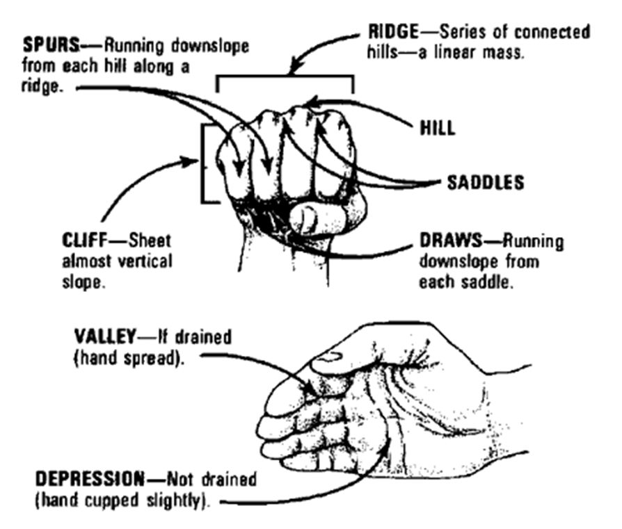
A point or small area of high ground. When you are on a hilltop, the ground slopes down in all directions.
Ridge
A line of high ground with height variations along its crest. The ridge is not simply a line of hills; all points of the ridge crest are higher than the ground on both sides of the ridge.
Valley
Reasonably level ground bordered on the sides by higher ground. A valley may or may not contain a stream course. A valley generally has manoeuvre room within its confines.
Saddle
A dip or low point along the crest of a ridge. A saddle is not necessarily the lower ground between two hilltops; it may be a break along an otherwise level ridge crest.
Depression
A low point or hole in the ground, surrounded on all sides by higher ground.
Minor Terrain Features
Draw
Spur
Cliff
Supplementary Terrain Features
Cut
Fill
Draw
Similar to a valley, except that it normally is a less developed stream course in which there is generally no level ground.
Caused by flash floods and can be found on flat terrain but are more often found along the sides of ridges.
Spur
Spur-a usually short, continuously sloping line of higher ground, normally jutting out from the side of a ridge.
Cliff
Cliff-a vertical or near-vertical slope. A cliff may be shown on a map by contour lines being close together, touching, or by a ticked "carrying" contour line. The ticks always point toward lower ground.
Cuts
A man-made feature resulting from cutting through raised ground, usually to form a level bed for a road or railroad track.
Fills
A man-made feature resulting from filling a low area, usually to form a level bed for a road or railroad track.
Hand method for remembering terrain features
Types of vegetation
Temperate deciduous forest
Coniferous forest
Jungle
Desert
Arctic
Grass or Open Area
Types of drainage
Rivers, lakes, delta, dams, swamps, creeks, ponds, culverts, canals, irrigation, reservoirs.
Three general ways to describe roads
Size (width, # of Lanes)
Surface
Interchanges, junctions, and intersections
Examples of describing road size
Highway
4 lane road
2 lane road
Single lane road
Trail (vehicle or foot)
Examples of describing road surface
Concrete
Asphalt
Gravel
Dirt
Examples of intersections
Traffic circle
Crossroad
Interchange
Examples of intersections
Junction
T- junction
Installation
An installation is a building or place that provides a particular service or is used for a particular industry, are either military or civilian structures.
Examples of installations
Airfields & Airports
Civil Industrial Complexes (Refineries, power plants, factories)
Dams
Military Headquarters
Field Hospitals
Tented camps
Recognising tented camp
A tented camp can usually be easily picked out by its organization and straight lines. Usually arranged in straight rows of tents within a compound area.
Usually designated parking area
In formation vice sporadic
Larger tent for mess and supplies
Command centre (tent size varies)
Recognising field hospital
Hospital can either be joining tent or mobile building structures for isolation and access routes
Generally in cross/X shape formation