Geography: Rivers
1/34
Earn XP
Name | Mastery | Learn | Test | Matching | Spaced |
|---|
No study sessions yet.
35 Terms
abrasion
Rocks carried by the river wear down the riverbed and banks.
attrition
Rocks being carried by the river smash together and break into smaller, smoother, and rounder particles.
hydraulic action
The force of the river against the banks can cause air to be trapped in cracks and crevices. The pressure weakens the banks and gradually wears it away.
solution (erosion)
When the water dissolves certain types of rocks, e.g. limestone.
saltation
Particles bouncing down the riverbed.
suspension
Fine solid material held in the water while the water is moving.
traction
large boulders and pebbles are rolled along the riverbed
solution (transportation)
the transport of dissolved chemicals
what does the long profile of a river show
is a line representing the river from its source to its mouth and shows how the river changes over its course.
what does the cross profile of a river show
shows a cross-section of a river's channel and valley at a certain point along the river’s course.
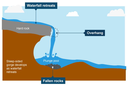
waterfalls
erosional landform
The soft rock is eroded quicker than the hard rock and this creates a step.
As erosion continues, the hard rock is undercut forming an overhang.
Abrasion and hydraulic action erode to create a plunge pool.
Over time this gets bigger, increasing the size of the overhang until the hard rock is no longer supported and it collapses.
This process continues and the waterfall retreats upstream.
interlocking spurs
upper course
hydraulic action deepens the river channel by a little cause most of the energy is used to overcome friction
freeze-thaw weathering broadens the valley out and deepens the channel. repeated weathering weakens the rock so fragments break loose and tumble down the hillside which is carried by the river
the bands of soft rock are eroded more causing projections of hard rock forming the interlocking spurs
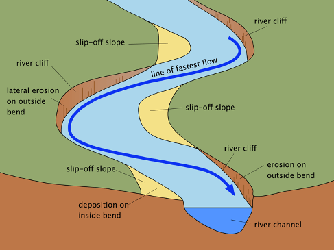
meanders
on the outside bend: erosion - as fast flowing water with lots of energy is directed to the outer bank
on the inside bend: deposition - where there is less water, there is more friction and slower flowing water therefore, the river deposits any sediment it carries
can migrate and do not always form oxbow lakes
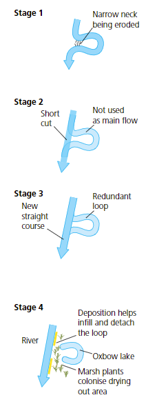
oxbow lake
meander loop gets bigger and a narrow piece of land separates the river channel (the meander neck)
there is continued lateral erosion and the neck becomes narrower
the river floods and the main flow of the river cuts straight across the neck
“short cut“ begins to break down the river bank and creates a new channel
the flood recedes, and the river reverts to normal meandering channel and this process repeats over and over with every flood again
loop of old river becomes detached and no longer gets river water - flood = deposition on new river banks
how are levées formed?
when a river bursts it’s banks, there is friction with the land which reduces velocity and causes deposition of heavy sediment closer to the river
each flood causes the banks to be built higher and the sediment is deposited on the river bed, raising the river
how is a flood plain formed?
The river in the lower course has many large meanders, which grow outwards over time. When a river floods the water spills out onto the surrounding land. The water loses velocity and deposits its load. Deposition of finer sediment called alluvium occurs (the larger materials have been deposited upstream first, leaving finer sediments and silts to be deposited in the lower course).
what happens in the upper course (erosion, transportation, deposition)
erosion: mostly vertical, hydraulic action
transportation: mostly traction, large boulders are moved
deposition: large boulders are deposited
what happens in the middle course (erosion, transportation, deposition)
erosion: less vertical, more lateral with attrition, abrasion and solution
transportation: mostly suspension, increased traction and the load becomes smaller
deposition: more, especially on inner bend of meanders
what happens in the lower course (erosion, transportation, deposition)
erosion: very little, mostly lateral
transportation: mostly suspension and solution
deposition: a lot of load, but small particles
describe the cross profile of the upper course and why
Steep sided, narrow and deep V-shaped valley. River channel takes up most of the valley floor.
Vertical erosion by the river is the dominant process - This creates a slope that weathered material from the valley sides can fall down. On reaching the river, this material is removed. rocks near the source tend to be harder - The valley sides are therefore not broadened out much by weathering and erosion so slopes remain steep.
describe the cross profile of the middle course and why
Valley broadens out. It now has a small flood plain. Valley sides are not as steep
The gradient is less steep, so the river begins to meander (bend) and erode laterally (sideways) into the valley sides. This broadens out the valley. In addition to this, the rate of weathering increases on the softer rocks of the valley sides. As the river uses more energy in lateral erosion, it is not able to remove all of the weathered material, so this builds up the valley floor to give it a more gentle profile
describe the cross profile of the lower course and why
Large expanse of flat flood plain on either side of the river
Deposition from floods builds up the flood plain, and meanders migrate (see page 158). This builds up and widens the valley
what human factors affect flood risk
Urbanisation - Increasing the amount of impermeable surfaces (concrete & tarmac, for example) decreases the time taken for water to flow into the river, and so increases the risk of flash flooding
Deforestation - Trees intercept the rain and so it takes longer for the rain to travel through the leaves into the river. Therefore, cutting down trees will speed up the time taken for rainwater to flow into the river, increasing the risk of flash flooding.
The Capacity of the River - If the river becomes filled with rubbish and debris, the channel’s size will decrease. This means the river can carry less water and so is more likely to flood.
what physical factors can affect flood risk
The rate and volume of rain (precipitation) falling - if there is a storm, and a large amount of rain falls in a short amount of time, the amount of water running into the river is increased. This increases the risk of flash flooding downstream.
Geology - If the area has many impermeable rocks, the rainwater can’t run into the soil and into underground storage. Instead, the rainwater runs straight into the river, increasing the risk of flash flooding on bad weather days.
Topography - The shape of the land will determine how quickly rainwater flows into the river. Steep hills with high gradients are more likely to have flash floods than gradual gradients.
hydrographs
Storm hydrographs represent the variation in the river’s discharge (the volume of water passing through the river channel at a specific point) within a short period. They are useful in showing how precipitation affects a drainage basin.
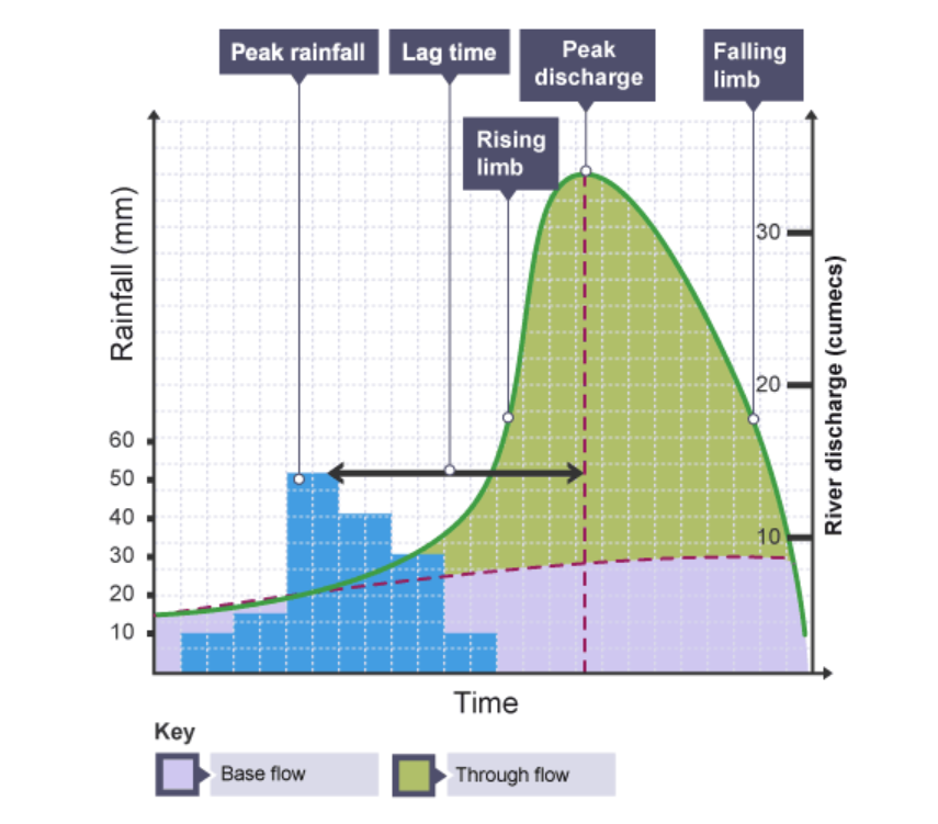
features and causes of a flashy storm hydrograph
desc.
short lag time
high peak
steep rising limb
causes
intense storm
impermeable rock
high, steep slopes
small drainage basin
few plants
features and causes of a subdued storm hydrograph
desc.
long lag time
low peak
gently sloping rising limb
causes
steady rainfall
permeable rocks
low slopes
large drainage basin
lot of vegetation
what is a drainage basin
A drainage basin is the area of land around the river that is drained by the river and its tributaries
dams and reservoirs
dam = large concrete barrier built across a river to impede its flow which causes the valley behind the dam to flood, forming a reservoir.
restricts the supply of water downstream, Water is released in a controlled manner through gates
pros
Provides hydroelectric power – turbines may be placed in a dam. Kielder Dam generates 6MW of electricity, enough to serve a town of 10,000 people.
Highly effective against floods – releases of water are highly controlled so there is virtually no risk of flooding
Promotes new habitats – these develop in and around a reservoir. At Kielder, there are conservation areas. The area has rare red squirrels
cons
The flooding of a valley displaces people, usually farmers from their homes
expensive (£167m), soils downstream can become less fertile
A concrete dam interferes with the path of migrating fish. Sediment is trapped behind the dam and this interferes with fish spawning grounds. Algae often collects behind a dam which deoxygenates the water
channel straightneing
when a meandering section of a river is engineered to be wider, straighter and deeper
pros:
reduces floodrisk - moving water out of the river quicker as less friction between bed and banks
home owners are more confident to invest in property - insurance cost reduces
cons:
expensive to dredge rivers (£5.8m)
changes in hydrology and flooding downstream and destroy habitats and damage homes further downstream
enbankments
artificially raised river bank. In raising the banks, more water is contained in the channel. This reduces the flood risk
pros
Safer from flooding – the channel now has an increased carrying capacity. It is less likely to burst its raised banks,
cheap compared to other hard engineering methods
provide habitats
cons
Embankments deprive people of easy access to the river for fishing and boating
not as reliable
higher maintenance
prone to erosion
flood relief channels
A flood-relief channel is an artificially made channel that is designed as a backup channel for a river that frequently floods. It works like a bypass
pros
A relief channel removes the risk of flooding from a designated area. Exeter’s relief channels protect around 3,000 properties.
Insurance costs are lower in the vicinity. The value of homes increases and houses are easier to sell
Some relief channels include artificial reed beds and grass-covered concrete sides. These provide new habitats.
pretty
cons
People living in the path of a relief channel have to be moved, causing disruption. Settlements downstream of a relief channel suffer from increased flooding
Flood-relief channels are expensive - long time before they are implemented
In the construction of relief channels, habitats are disturbed. The level of water in a relief channel varies considerably. This provides an unreliable habitat
flood plain zoning
Flood plain zoning is where land in a river valley is used in such a way as to minimise the impact of flooding
Local authorities are required to use these maps to produce flood-risk assessments and to guide decisions regarding new building applications. More permanent structures can be installed further away from the river without any substantial economic or social costs, should flooding occur.
flood warnings
The EA and other agencies, such as district councils, and the Water and Highways Authorities co-ordinate efforts to devise and carry out action plans for areas at risk.
The meteorological office analyses data from its 200 automated weather stations and passes this to the EA, who uses it, along with river level data, to provide updated flood alert information. The media, and occasionally sirens or loudspeakers, publicise this information. The EA provides a flood map website, a three day flood forecast, and personalised warnings
river restoration
River restoration is when a river that has previously been hard engineered is restored to a natural channel