GEOGRAPHY coastal systems and landscapes單詞卡 | Quizlet
1/102
There's no tags or description
Looks like no tags are added yet.
Name | Mastery | Learn | Test | Matching | Spaced | Call with Kai |
|---|
No study sessions yet.
103 Terms
coast inputs
energy (wind), river sediment, sediment transported by the sea, waves, the sun, sea defences
coast outputs
sediment washed out to sea (ocean currents), sediment carried further along the coast, loss of wave energy, coastal landforms, evaporation
coast stores
1. beaches
2. sand dunes
3. spits
4. bars/tombolos
5. headland & bays
6. cliffs
7. wave-cut platforms
8. caves
9. arches
10. stacks
11. stumps
12. salt marshes
coast processes
wave action, LSD, weathering, erosion, transportation, deposition
negative feedback loop
nullifies the effects - brings the environment back to the equilibrium
negative feedback loop example
1. when a destructive wave from a storm loses its energy, excess sediment is deposited as an offshore bar
2. the bar reduces further wave energy which protects the beach from further erosion
3. over time the bar gets eroded instead of the beach
4. once the bar is gone the system goes back to equilibrium and conditions are normal
positive feedback loop
amplifies the effects - moves the environment further from the equilibrium
positive feedback loop example
1. people walking over sand dunes destroys the vegetation and causes erosion
2. since the roots from the vegetation hold the sand dunes together, once removed this increases the rate of erosion
3. eventually the sand dune will be completely erode taking the beach further from its original state
what affects the shape of the coast?
waves, sediment, geology, weathering, mangroves, climate change, sea defences
the littoral zone
the area of land between the cliffs/dunes on the coast and the area that is beyond the influences of the waves - is constantly changing due to tides/storm surges/sea level change/human intervention
the fetch
the maximum distance of open water over which wind can blow to form a wave
2 sources of energy in coastal environments
1. wind energy
2. wave energy
wind energy
wind creates waves due to frictional drag; it varies depending on strength, duration and prevailing wind direction
wave energy
transfers energy from A to B

wave formation
1. wind blows over the surface of the sea creating friction
2. this causes ripples (leads to a circular orbital motion in the water) which develops into waves
3. the longer the fetch the more powerful a wave becomes

factors that affect wave energy
1. strength of the wind
2. duration of the wind
3. size of the fetch
2 types of waves
constructive and destructive
constructive wave
gentler waves, 6-9 waves per minute, carry sediment up the beach, strong swash, weak backwash, builds up the beach, shorter flatter beaches
destructive waves
form during stormy weather, strong waves, 10-15 waves per minute, strong backwash, weak swash, destroy the beach
sediment sources
1. rivers
2. cliff erosion - most erosion occurs during the winter months
3. longshore drift
4. wind - blows sand along the beach
5. estuaries
6. offshore - waves/tides/currents bring it further out to sea, however tsunamis & storm surges bring it back to the coast
7. glaciers - store sediment in the cryosphere and in antarctica/greenland/alaska flow directly into the ocean

wave refraction formation
1. headlands creates areas of shallow water - slows the wave down
2. the wave in deeper water will move faster - the wave bends
3. energy is concentrated onto both sides of the headland - increasing erosion but deposition in the bay

sediment cell
lengths of coastline that are relatively self contained in terms of sediment movement, each cell is separated from the next by boundaries such as deep waters or headlands (are closed systems)
sediment cell & dynamic equilibrium
dynamic equilibrium in a sediment cell is where inputs & outputs of sediment are constant/balanced, however these can be impacted by long-term human interventions (engineering strategies) or short-term natural changes
sediment cells around the UK
11 around england and wales, 11 around scotland (sub-cell 5 = christchurch, dorset)
sediment budget
the balance between sediment being added and removed (from a sediment cell)
tides
the periodic rise and fall in sea level, a result of the gravitational pull of the moon (and sun)
tides explained
the moon pulls water towards it creating a bulge (high tide), this is mirrored on the other side of the earth, as the moon orbits the earth the high tide follows it

spring tides
2 times a month when the sun and moon are aligned, the gravity is extra strong, higher than average tide and lower than average tide = large tidal range

neap tide
2 times a month when the sun and moon are at 90° to each other in relation to the earth, so the sun's gravity cancels out that from the moon, smaller tidal range

rip currents
powerful underwater currents occurring in areas close to the shoreline - very dangerous
coastal geomorphological processes
weathering, mass movement, erosion, transportation, deposition
3 types of weathering
1. mechanical weathering
2. chemical weathering
3. biological weathering
weathering
the breakdown of rock in situ
mechanical weathering (freeze-thaw weathering)
1. a small crack forms in the rock
2. water fills the crack when it rains
3. overnight the water inside the crack and freezes (ice expands by 10%) making the crack wider
4. the cycle is repeated until the rock breaks open

chemical weathering (carbonation)
carbon dioxide in the air mixes with the rainwater making carbonic acid, this breaks down/reacts with the minerals in the rocks causing weathering
biological weathering
caused by movements of plant or animals, a plant may grow in a crack in a rock and when its roots grow it causes the crack to widen and break open

types of erosion
1. hydraulic action
2. abrasion
3. attrition
4. solution
hydraulic action
waves strike a cliff face compressing air in the cracks of the rock
abrasion
waves which contain sand and larger fragments erode the coast (sand paper effect)
attrition
waves cause loose pieces of rock debris to collide with each other, grinding and chipping each other progressively becoming smaller and smooth
solution
acids contained in sea water will dissolve some types of rock (limestone or chalk)

factors that influence erosion rates
1. geology - rock strength
2. beach presence - beaches soak up wave energy
3. sea floor - controls the wave energy arriving at the coast
4. sea defences
5. climate change - stronger storms - destructive waves
types of transportation
1. traction
2. suspension
3. saltation
4. solution
traction
the rolling of large sediment along the sea floor (tractor)

suspension
small particles are carried in the water (silt/clays) which make the water look cloudy

saltation
a particle that is too heavy to remain in suspension, bounces along the floor

longshore drift
45° swash, 90° backwash, swash in the same direction as the prevailing wind

deposition
when the sediment becomes too heavy for the water to carry - the wave loses its energy
flocculation
when clay particles clump together due to chemical attraction and then sink due to their high density
aeolian deposition
the dropping of sediment carried by the wind
3 types of aeolian deposition
creep, saltation, suspension
mass movement
the downhill movement of weathered rock material under the influence of gravity
mass movement depends upon...
1. how cohesive the sediment is
2. the slope height/angle
3. the grain size
4. temperature
5. the level of ground saturation
landslides
the sudden movement of large amounts of material down a slope

soil creep
particles being lifted from the ground and dropped under the influence of gravity, creates terracettes
how does soil creep happen?
1. freeze-thaw weathering - lifts particles at right angles and when thawed they are slightly in a different place
2. wetting and drying - when moisture is added it will swell and expand, and when it is dried it will drop back down

mudlfows vs. earthflows
MF: when heavy rain/floods saturate a large area of material, when it is filled with too much water or there's not enough vegetation, it will move downhill (move fast)
EF: not saturated with moisture (move slower)
rockfalls
vertical movements of dry, loose material (quickest form of MM)

slumping
material moves downhill along a curved surface (most common in east yorkshire or north norfolk)

landforms of erosion
1. headlands and bays
2. cliffs and wavecut platforms
3. geos, caves, blow holes, arches and stacks
headlands and bays
form along discordant coastlines, soft rock erodes much faster than hard rock, hard rock sticks out (headlands) leaving softer eroded dips in the coastline (bays) which receive deposition from wave refraction
cliffs and wavecut platforms
sea erodes the base of a cliff (undercutting), erosion (abrasion) results in the formation of a wave cut notch, notch gets bigger and eventually collapses, backwash carries the rocks away leaving a wave cut platform

geos, caves, blowholes, arches, stacks and stumps
waves erode joints and cracks through hydraulic action and abrasion to form caves, (occationaly weathering erodes the cave roof creating a blow hole), caves made larger through erosion and weathering until an arch is formed, arch collapses to leave a stack, stack eroded to leave a stump

concordant coastlines
rock layers are parallel to the coastline, same type of rock along its length, similar rates of erosion (limestone)

discordant coastlines
rock layers are perpendicular to the coastline, have lots of headlands and bays due to soft rock (clay) being eroded much faster/easier than hard rock (limestone/chalk)

landforms of deposition
beaches, bars, sand dunes, spits, tombolos
spits
a stretch of sand or shingle extending from the mainland out to sea

formation of a spit
1. need a change in direction of the coastline (a headland)
2. LSD is no longer able to carry the sediment and it is deposited
3. LSD further builds on the submerged bar forming an above-water spit
4. vegetation might start to grow making it stable
5. creates a salt marsh due to the sheltered/saline environment behind the spit

compound spit
a spit with a number of recurved 'spurs' along their length

salt marsh
areas of flat, silty sediments that accumulate around estuaries

formation of a salt marsh
1. formation of a spit
2. water behind the spit becomes sheltered from the wind and waves
3. gentler waves enter this area depositing finer material (silt/clay)
4. sediment builds up becoming a mudflat
5. vegetation grows and pioneers colonise
6. vegetation slows tidal currents and traps more sediment

formation of a bar
1. formation of a spit
2. if the supply of sediment is not interrupted (by a river) both ends might join to land forming a lagoon behind the bar

formation of an island
1. formation of a spit
2. if the supply of sediment is interrupted, the sand at the neck will be cut off
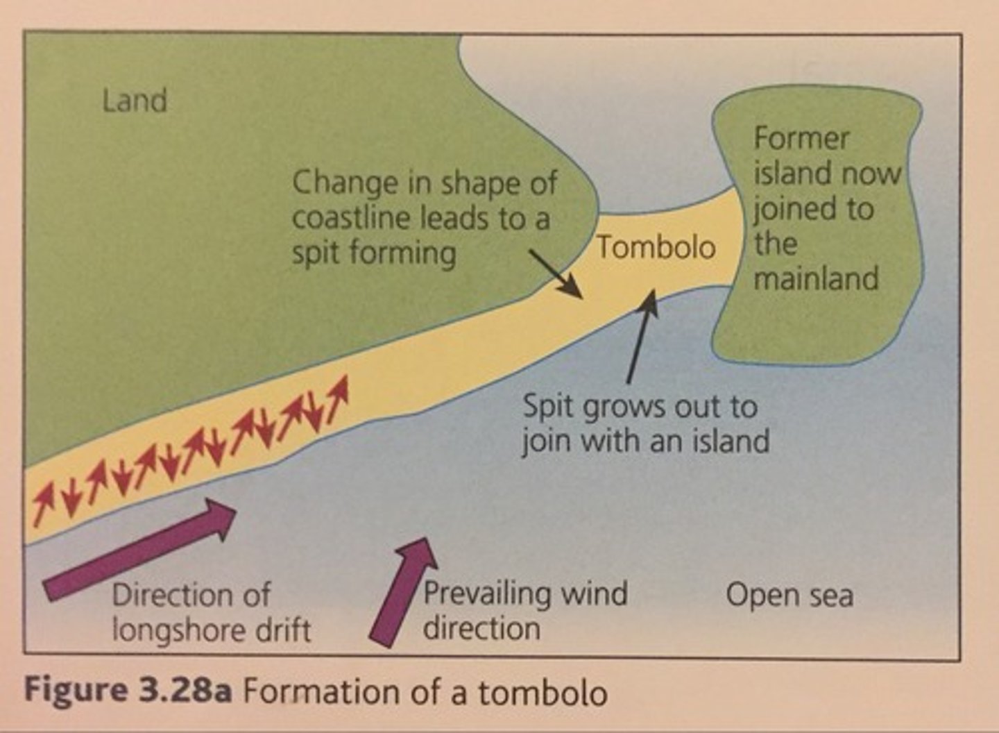
formation of a tombolo
1. change in shape of coastline
2. a spit grows
3. joins an offshore island
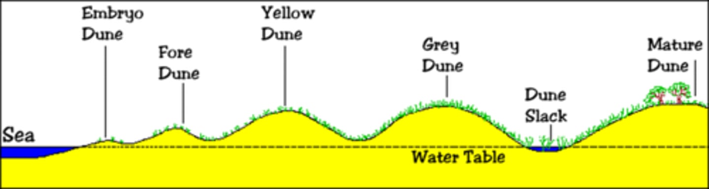
formation of a sand dune
1. through saltation medium sized particles bounce up the beach
2. sand builds up 45° on the seaward side
3. pioneers colonise blocking further sand forming an embryo dune
4. grey dunes have a high diversity of species because they are able to survive due to shelter from other dunes
5. in the mature dune sand turns to soil so there is an even higher biodiversity, vegetation gains height
estuary
a habitat in which the fresh water of a river meets the salt water of the ocean, a salt marsh is a type of estuary (a sediment sink)
in what conditions do salt marshes develop?
sheltered areas, where salt and freshwater meet, no strong tides or currents
isostatic change
local change in uplift or downthrust of the crust depending on the amount of ice on the land causing a change in relative sea levels
eustatic change
global change depending on the volume of water in the oceans (sea level change)
submerging land
during glacial periods land masses sink deeper into the mantle (compression) submerging landforms (rias/fjords)
emerging land
during interglacial periods ice sheets start to melt meaning land masses begin rising (decompression)
emergent landforms
raised beaches, sea caves/arches

submergent landforms
rias, fjords, dalmation coastlines
sea cave/arch (emergent landform)
past coastal erosion that are now well above the active coastal zone
raised beach (emergent landform)
a beach that was at sea level but is now well above
ria (submergent landform)
submerged river valley, water is generally shallow

fjord (submergent landform)
submerged glacial valley, when the ice melted the valley was flooded, water is uniformly deep, classic U shape - ullsfjorden in norway

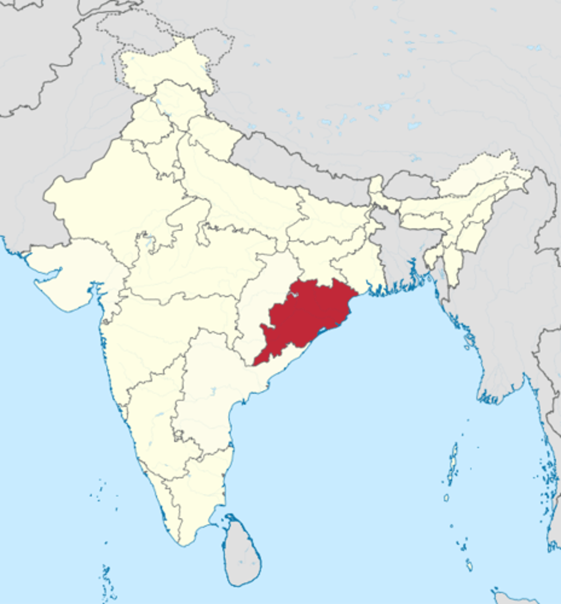
odisha coastline AO1
south-east coast of india, 9th largest state area in india, population: 43.73 million, 480km coastline, have high risks of flooding due to coastline being at sea level, 28% of odisha's coastline is eroding/21% is stable/51% is accreting (more deposition in the summer & more erosion in the winter)
odisha coastline features
1. beaches - soft geology
2. deltas
3. mangroves
4. lagoon - chilika lake (impacted by cyclone fani - altered the salinity of the lake)
5. dunes

odisha coastline hazards
1. strong destructive waves coming from the indian ocean (large fetch)
2. cyclones - cylone phalin: 44 deaths, displaced 1 million coastal residents, 500,000 hectares of farmland lost, US$696 million lost
economic opportunities odisha's coastline brings
1. local people are employed in coastal fishing
2. offshore oil and natural gas mining
3. offshore wind, tidal or wave power
4. tourism - beaches/historical sites (temples)/wildlife sanctuaries
5. 35% of the coast contains minerals: clay & limestone that can be used in the north of india
environmental opportunities odisha's coastline brings
1. large fish stock
2. mangroves
3. bird sanctuary in chilika lake
ICZM's aims for odisha
1. to establish sustainable levels of economic and social activity
2. to resolve environmental, social and economic challenges and conflicts
3. to protect the coastal environment
what did the ICZM do in odisha?
1. regenerate the mangroves
2. embankment renovation (geo-synthetic tubes) absorb tidal wave energy - stops erosion
2. established warning & built cyclone shelters for future cyclone events
the role of mangroves to odisha's coast
1. dense root system traps sediment - stabilises the coastline & prevents erosion (districts with denser mangrove cover have a 50% higher accretion) - mangrove cover in odisha: 1435 km2 - during the 2021 cyclone yaas, the national park was saved by the mangrove cover
2. adapts to rising sea levels caused by climate change
3. birthing ground for 3/4 of all tropical fish/25% of fish's food source (maintains biodiversity)
4. better than hard engineering strategies - cheaper & more cost-effective - carbon sequestration
holderness coastline AO1
east yorkshire coastline in england, fastest eroding coastline in europe: 2 meters per year, 61km from flamborough to spurn point, B1242 road is the main north-south transport link therefore receiving lots of hard-engineering strategies
holderness coastline - causes of erosion
1. prevailing wind causing destructive waves
2. cliffs are made of soft bolder clay that eroded rapidly when saturated
places in holderness: flamborough
1. white chalk cliffs
2. contains a cave/arch/stack caused by the destructive waves it receives

places in holderness: hornsea
1. boulder clay cliffs & wide/steep beaches
2. the SMP 'held the line' & they built a concrete sea wall & groynes
3. needed to protect hornsea mere (yorkshire's largest lake) and the high population density (8,000 people) which contained a wide range of infrastructure
4. the hard engineering has shown to be very effective at protecting against erosion & stormy weather
5. the groynes have boosted tourism since it has maintained & widened the sandy beaches
6. however the hard engineering strategies have increase erosion in the south
places in holderness: mappleton
1. attempts at coastal management but had negative impacts