Groundwater
1/79
There's no tags or description
Looks like no tags are added yet.
Name | Mastery | Learn | Test | Matching | Spaced |
|---|
No study sessions yet.
80 Terms
groundwater
water found within void spaces of geological material beneath the surface of the earth
exists in saturated layers of sand, gravel, certain type of clay material, and cracks within crystalline rock
water budget equation
P = R + ET + I + ∆S
P = precipitation
R = runoff
ET = evapotranspiration
I = interception
∆S = groundwater storage
water distribution
All Water
97.6% ocean and saline lakes
2.4% freshwater
Freshwater
87% ice and snow
13% liquid water
Liquid Freshwater
95% groundwater
3% lakes, rivers, streams
2% soil moisture
groundwater
major source of all fresh drinking water supplies in some countries
stored underground in aquifers
highly vulnerable to pollution
understand for management and protection of water resources
comes from precipitation that filters through vadose zone (important environmental role in GW systems) to reach the zone of saturation where GW flows
groundwater rate of infiltration
a function of soil type, rock type, antecedent water, and time

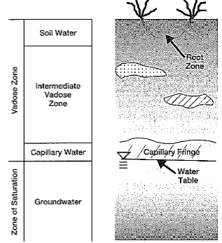
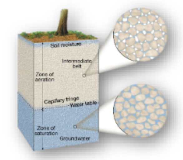
vadose zone
area between land surface and the top of the aquifer where the material are not saturated with water, but are filled primarily with air
includes all the material between the Earth’s surface and the zone of saturation
unsaturated zone; means shallow
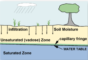
water table
the upper boundary of the zone of saturation

capillary fringe
a layer of variable thickness that directly overlies the water table
drawn up into this layer by capillary action

World Water Day (1998)
international observance of this day is an initiative that grew out of the 1992 United Nations Conference on Environment and Development (UNCED) in Rio de Janeiro
United Nations General Assembly designated March 22
invisible resource playing a major role in global economics, political conflicts, and personal health
groundwater hydrology
the study of the characteristics, movements, and occurrence of water found beneath the land surface
ancient groundwater use
Qanats development in the Middle East, Africa, China, and South America
hydrologists and engineers of Roman Empire used GW from springs as water resources for aqueducts to their cities
early Greek philosophers - Homer (800 BC), Thales (636-546 BC), Plata (427-347 BC) → GW originated from sea water → purified as move through land
Roman Architect and water management
Marcus Vitruvius Pollio (70-25 BC) hypothesized that precipitation (P) and infiltration (I) source groundwater
precipitation falling in mountains infiltrated the earth’s surface and led to streams and springs in the lowlands
17th century
Pierre Perrault (1611-1680) measured P and its relationship to runoff in the seine river watershed
discovered that P increased discharge of the seine river by 600%
confirmed and supported Vitruvius theory 1700 years earlier
Leonardo da Vinci & Bernard Palissy (15th century)
independently reached an accurate representation of the hydrologic cycle
hydrologic variables quantified in 17th century
Pierre Perrault, Edme Mariotte, and Edmund Halley (16th century)
by measuring rainfall, runoff, and drainage area, Perrault showed rainfall was sufficient to account for the flow of the Seine
Mariotte combined velocity and river cross-section measurements to obtain discharge in the Seine
Halley showed evaporation from Mediterranean Sea was sufficient to account for the outflow of rivers flowing into the sea
18th century advancements
Daniel Bernoulli’s piezometer
Bernoulli’s equation (classical formulation of energy loss during fluid flow)
Pitot tube
Chezy formula
19th century
development in groundwater hydrology
Darcy’s Law
Dupuit-Thiem well formula
Hagen-Poiseuille’s capillary flow equation
lithology
the physical characteristic of a mineral composition: grain size and density of geologic material
stratigraphy
describes composition and age of sediment, lenses, and other formations
structure
cracks, folds, and other formation of geologic systems
sedimentary rocks
weathered and eroded igneous and metamorphic rock
conglomerate
sedimentary rock composed of rounded and gravel-sized particles
sandstone
sedimentary rock composed of sand-sized particles
siltstone
sedimentary rock composed of particles smaller than gains of sand
shale
sedimentary rock whose original constituents were clays or muds
fines
very small particles form weathered or eroded sedimentary rocks similar in size to talcum powder
geologic work of groundwater
dissolves rocks
mildly acidic (weak carbonic acid; forms when rainwater dissolves carbon dioxide form the air and from decaying plants)
carbonic acid reacts with calcite in limestone to form calcium carbonate (CaCO3) a soluble material
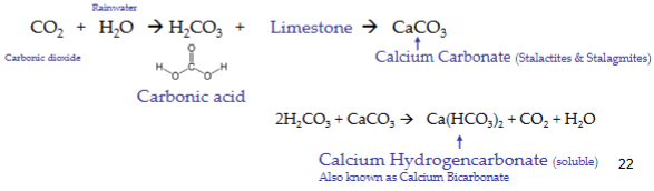
karst
geological terrain where significant solution of carbonate rocks has occurred due to flowing groundwater
sedimentary
sinkhole
dissolved limestone, carbonate rock, or salt beds, and the creation of large holes at the land surface
sedimentary
caverns
landscapes that have been shaped mainly by the dissolving power of GW (karst hydrology)
composed of dripstone (calcite deposited das dripping water evaporations, includes stalactites from the ceiling and stalagmites from the floor)
irregular terrain, sinkhole or sinks (accompanied by collapse), lack of surface drainage (streams)
glacial till
rock debris varying from clays to mixtures of clay, sand, gravel, and boulders
glacial outwash
deposit of boulders, pebbles, gravel, sand, and fines which were carried by the floodwaters after glaciers melted (valleys)
alluvial valley
permeable formation that can hold considerable amount of water
alluvium
sediment deposited by flowing rivers
fluvial is the process
tectonic formations
tectonic activities can create fissures and fractures that hold GW
arid locations
can have low infiltration rates due to hard, sunbaked land surfaces
impermeable surfaces
saturated zone
all open spaces are filled with water
GW table
top of the saturated zone of GW
water level in a well
water level in an unconfined aquifer
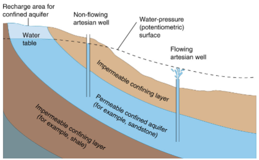
pressure (potentiometric) surface
the level to which water will rise in wells in a confined aquifer
confined aquifer
aquifer that is overlain by a confining bed of geologic material
recharge area

unconfined aquifer
aquifer with no confining bed of material between the saturated zone and the land surface
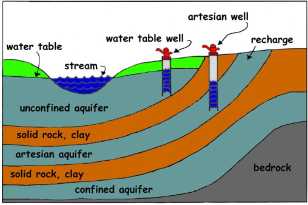
confining layer
impermeable
percolation
downward movement of water from the land surface to the aquifer
factors: climate, terrain, geology, and vegetation groundcover
aquifer
underground water-bearing geologic formation that can store and yield usable amounts of water
materials: sand, gravel, sandstone, limestone, and fractured rock
means to bear or carry water
consolidated rock aquifer
tightly bound geologic formation composed of material almost impervious, and doesn’t allow GW to move easily
ex: sandstone, limestone, granite
unconsolidated rock aquifer
loosely bound geologic formation consisted of granular material (sand, gravel), and generally yields larger amount of GW
fractured aquifer
found in consolidated rock that contains usable amount of water in cracks, fissures, joints
ex: granite, basalt
saturated thickness
total water bearing thickness of an aquifer
aquitard
a geologic formation that restricts the flow of GW from one aquifer to another
aquiclude
formation containing water, do not transmit significant quantities of water
aquifuge
formation does not contain nor transmit water
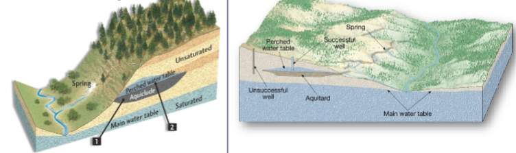
perched aquifer
localized zone of saturation above he main water table created by an underlying layer of impermeable material
artesian conditions in confined aquifers
higher precipitation causing water to emerge at the land surface as a spring, from a well, or fault
similar to city water systems
Ogallala aquifer
(high plains aquifer)
largest aquifer in North America
175,000 square miles (groundwater = Lake Huron)
1 ft < aquifer thickness < 1300 ft
most GW from it used for irrigation
GW mining in some areas (pumping greater than recharge)
pore spaces in aquifers
openings within the geologic material, providing GW to reside or move through under the force of gravity
porosity of aquifers
ratio of void space in a geologic formation to the total volume of the formation
p = Vvoid/Vtotal
porosity ranges for sediments
well-sorted sand or gravel 25-50%
sand and gravel, mixed 20-35%
glacial till 10-20%
silt 35-50%
clay 33-60%
cubical packing
(porosity)
each sphere sits directly on the crest of the underlying sphere
porosity = 47.65%
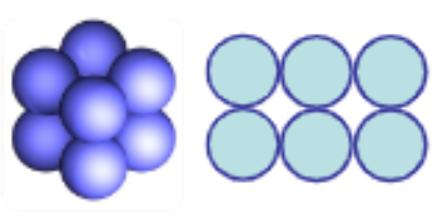
rhombohedral packing
(porosity)
the spheres lie in the hollows formed by 4 adjacent spheres of the underlying layer
lower overall porosity as void spaces occupied by grains of smaller diameter
porosity = 25.95%

total porosity
includes all pore space in the sample
effective porosity
accounts only for interconnected pore space of the sample
primary porosity
intergranular porosity if it was formed during the formation of the sediment
secondary porosity
the result of fracturing, faulting, and dissolution of rocks (karsts) created after a rock is formed
representative elementary volume (REV)
(porosity)
a sample that is sufficiently large to contain a great number of pores allowing to define a mean property and sufficiently small so that the parameter variation from one domain to the next may be approximated by continuous functions
size of this for a fractured rock is much larger than that for porous medium
transmissivity
rate at which GW moves laterally through the saturated thickness of an aquifer with a hydraulic gradient = i = 1
T = Kb
volume of water flowing through a cross-sectional area of an aquifer that is 1ft x aquifer thickness (b) under a hydraulic gradient (K) of 1ft/1ft in a given amount of time (usually a day)
specific yield (Sy)
the ratio of the volume of water that drains from a saturated rock owing to the attraction of gravity to the total volume of the rock
Sy = V water drain due to gravity / V total sample
surface tension
some of the water molecules cling to the surface because of surface tension of the water
specific retention (Sr)
(aquifer)
the ratio of the volume of water an aquifer can retain against gravity drainage to the total volume of the aquifer
porosity (n) = Sy + Sr
permeability (k)
the ability of a material to transmit a fluid; measure of how fast the fluid can travel through the rock or sediment
usually correlates with porosity, but not always
function of the size of the pore opening
smaller grains = larger surface contacts = greater frictional resistance to flow = lower intrinsic permeability
grain-size classification
well sorted sand - grain of sand of uniform size
poorly sorted sand - small particles fill in pore space between larger grains
porosity of 30% in sand/gravel formations = significant storage space for GW = a good aquifer
porosity of 15% in small grain sand with finer-grained clay = fairly tight & restrictive
igneous rock with a porosity <1% = water-tight barrier
clay & shale with numerous porous openings, yet voids too small for water movement (impervious) = GW barrier
hydraulic conductivity of aquifers (K)
the proportionally constant in Darcy’s law, which relates the amount of water which will flow through a unit cross-sectional area of an aquifer under a unit gradient of hydraulic head
K = ease with which water can move through pore spaces or fractures
components: porosity, permeability, specific yield, specific retention
units: length/time = velocity
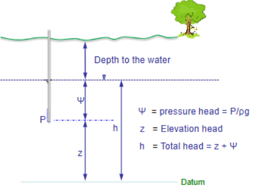
hydraulic head
fluid potential to flow through porous media = mechanical energy per unit mass of fluid
elevation = Z; pressure = P; velocity = v; density = ρ; volume of unit mass = V=1/ρ
manometer
(hydraulic head)
P = ρgψ +po
Ψ = height of liquid above P
po = atmospheric pressure (standard state)
ψ = h−z p = ρg (h−z) +po
fluid potential at any point P in a porous medium is the hydraulic head at that point multiplied by the acceleration due to gravity
Darcy’s Law
an empirical law equation by which the discharge (flowrate) of GW can be calculated; valid for flow in any direction; linear law (y=ax); works for laminar flow; macroscopic law
Q = A x K x (∆H/L)
Q = discharge; A = cross-sectional area of flow; K = hydraulic conductivity; i = ∆H/L (hydraulic gradient); L = distance between the 2 head drops
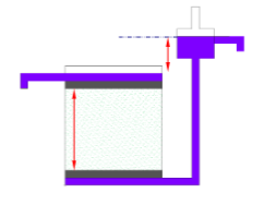
constant head permeameter
water in the supply reservoir is kept at a constant head
used for non-cohesive sediments (sand)
head should never be more than about ½ the sample length
water moves through sample at a steady rate
hydraulic conductivity determined from variation of Darcy’s Law
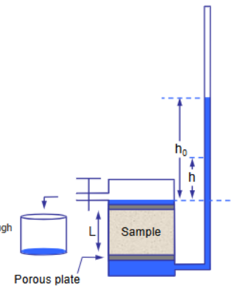
falling-head permeameter
homogeneous
a unit that has the same properties at all locations
ex: an aquifer where K doesn’t vary over space
equivalent hydraulic conductivity (Ke) for a __________ formation hydraulically equivalent to a system of heterogeneous formations
heterogeneous
formation where properties change spatially
ex: aquifer where K varies over space
most aquifers
equivalent hydraulic conductivity (Ke) treats this as a homogeneous one
anisotropic
materials where the permeability or conductivity at a point has a directional dependency
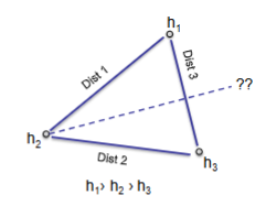
groundwater flow gradient graphical method
draw a line to connect each well
note the water elevation in each well
measure the map distance between a well pair
find the difference in elevation between a well pair
find map distance for each unit change in head for a well pair by dividing the head difference by the map distance between the well pairs
mark even increments along the line between the well pair, select the increment length so that each increment is a convenient length