Sectional Chart Interpretation: Basic Symbols
1/62
There's no tags or description
Looks like no tags are added yet.
Name | Mastery | Learn | Test | Matching | Spaced |
|---|
No study sessions yet.
63 Terms
soft
The circle symbol indicates an airport with a ____ surface
tower-controlled
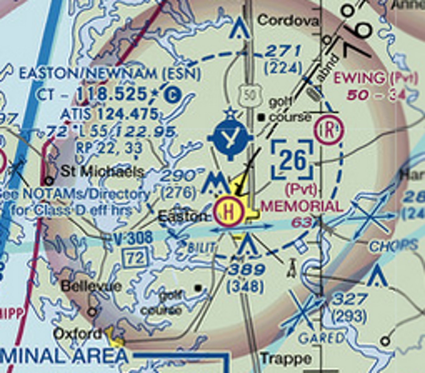
Easton airport is colored blue because it is a ____-____ airfield

D
The dashed blue circle around this airfield indicates Class ____ airspace
non-tower
Cape May County airfield is colored magenta to indicate it is a ____ airfield
[non-tower] / [tower-controlled]
![<p>Cape May County airfield is colored magenta to indicate it is a ____ airfield</p><p>[non-tower] / [tower-controlled]</p>](https://knowt-user-attachments.s3.amazonaws.com/308b2951-d04d-4d7e-8d0a-d87bb9afe41d.jpg)
restricted
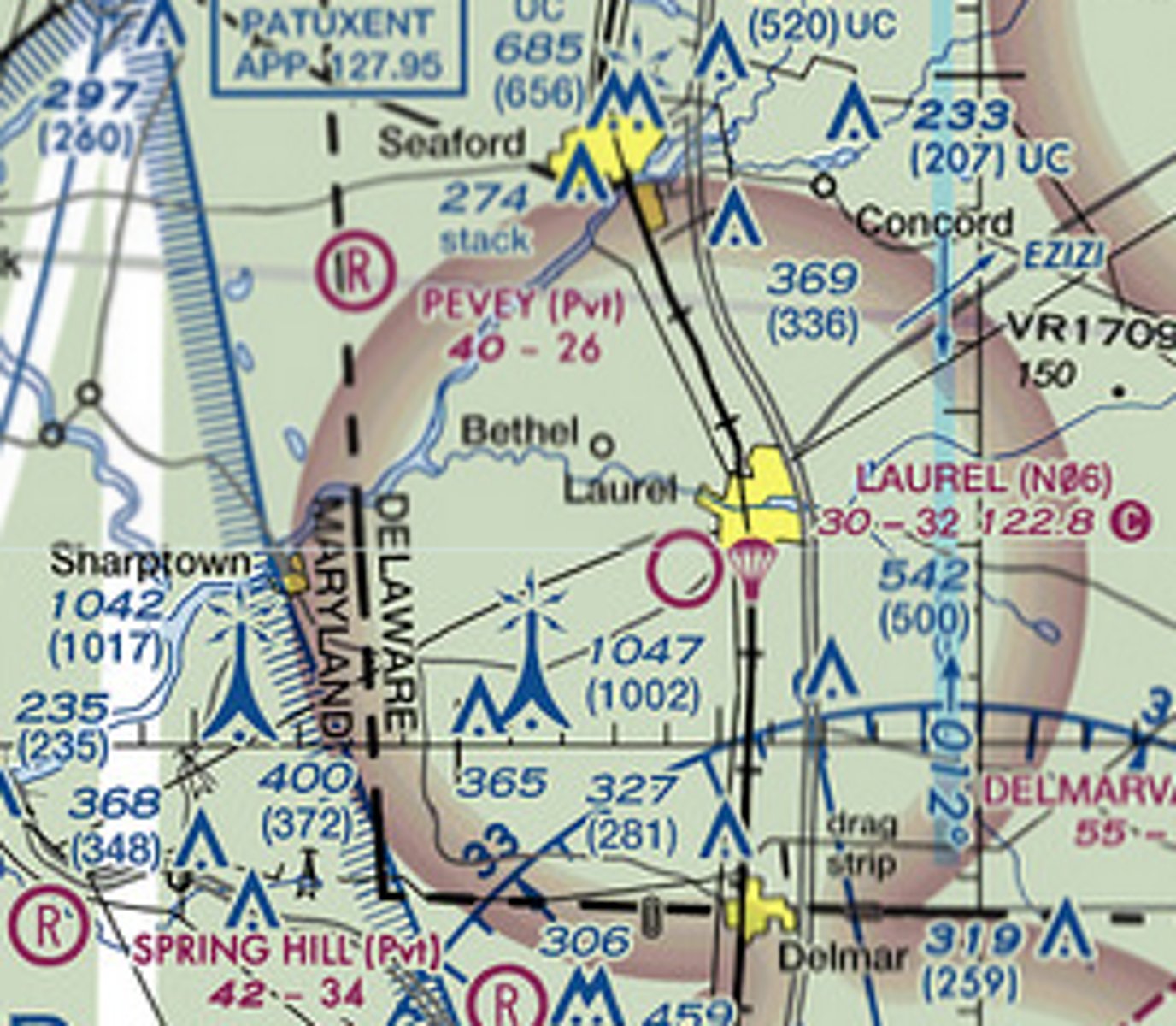
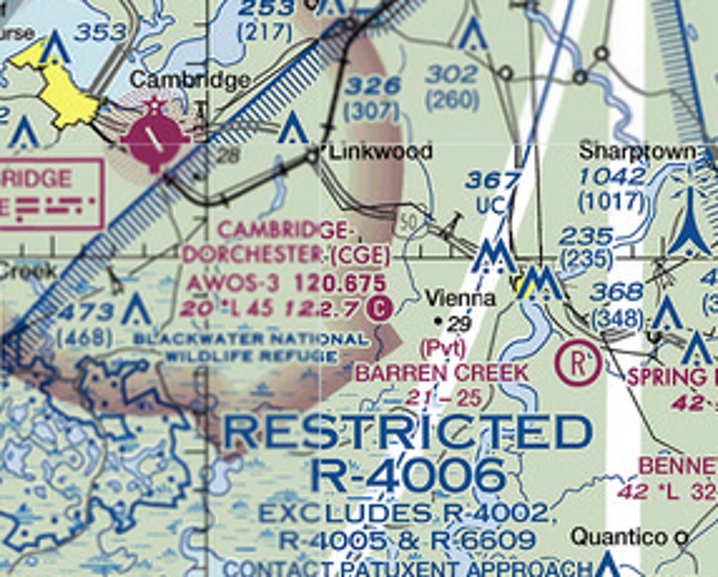
The blue hatched boundary immediately Southeast of Cambridge airport indicates a ____ area
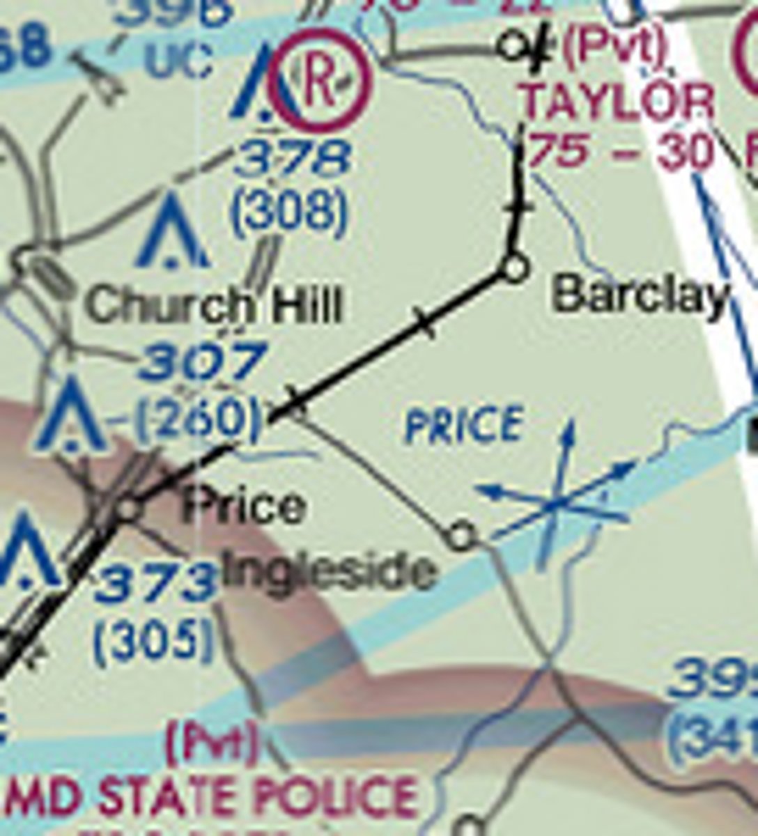
railroad track
The sectional chart shows a ____ running through the small town of Barclay
B
The airspace with a solid blue boundary and altitude limits of 4500 feet (floor) and 10,000 feet (ceiling) is Class ____ Airspace
C
The airspace with a solid magenta boundary is Class ____ Airspace
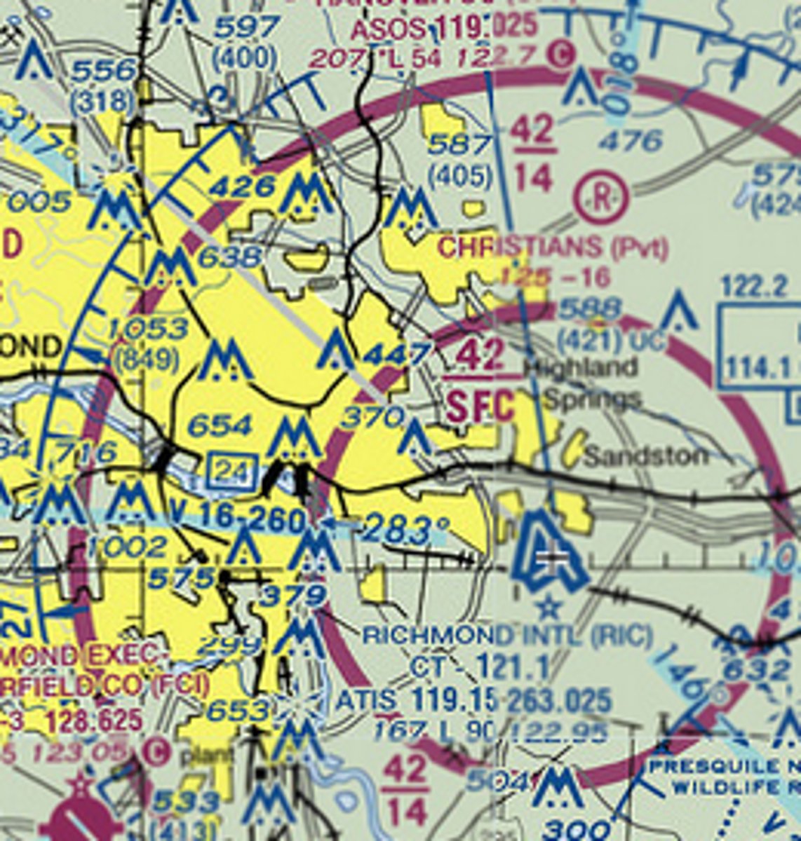
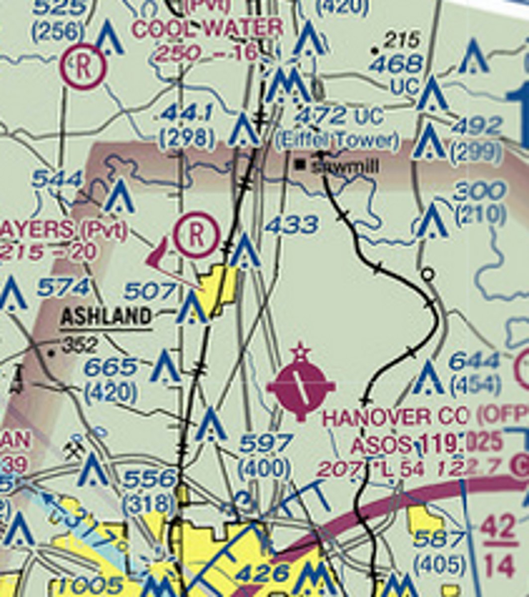
644
Directly East of Hanover County Airport is a tower. It extends up to ____ feet MSL
JGG
The three character airfield identifier for Williamsburg-Jamestown airport is __ __ __

rotating beacon
The star symbol above the airport symbol indicates the airfield has a ____ ____

non-directional beacon
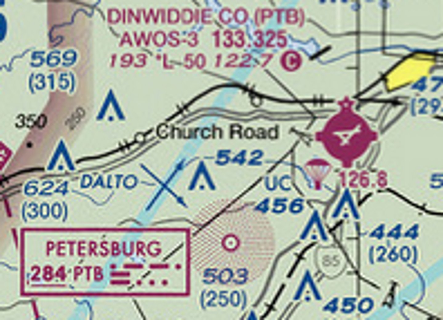
4 nm Southwest of Dinwiddie County airport a circular pattern of magenta dots marks a navigational aid known as a . . .

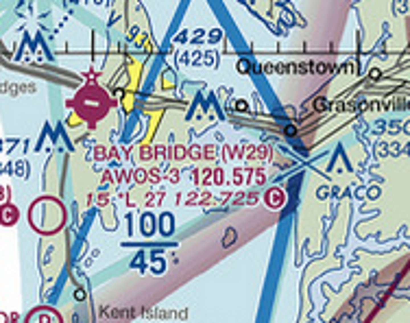
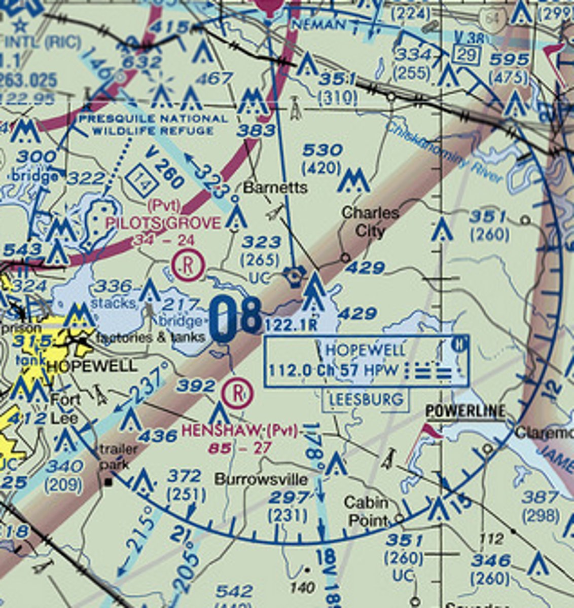
112.0
The VHF navigational frequency for the Hopewell VORTAC is ____
seaplane
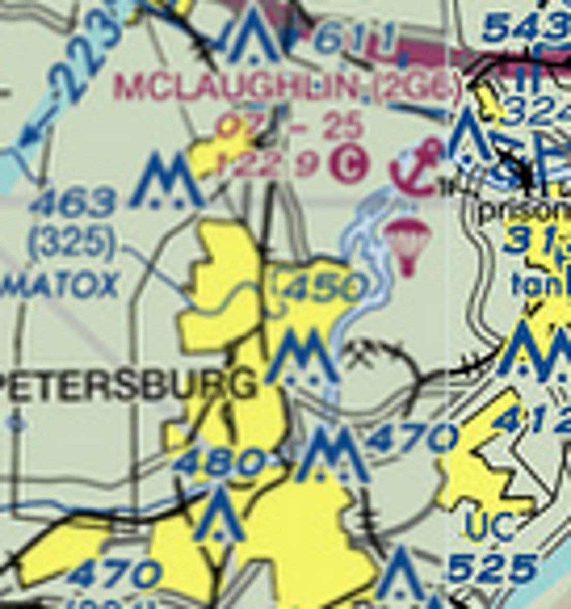
The anchor symbol below the text "(2G6)" indicates a ____ base
VOR
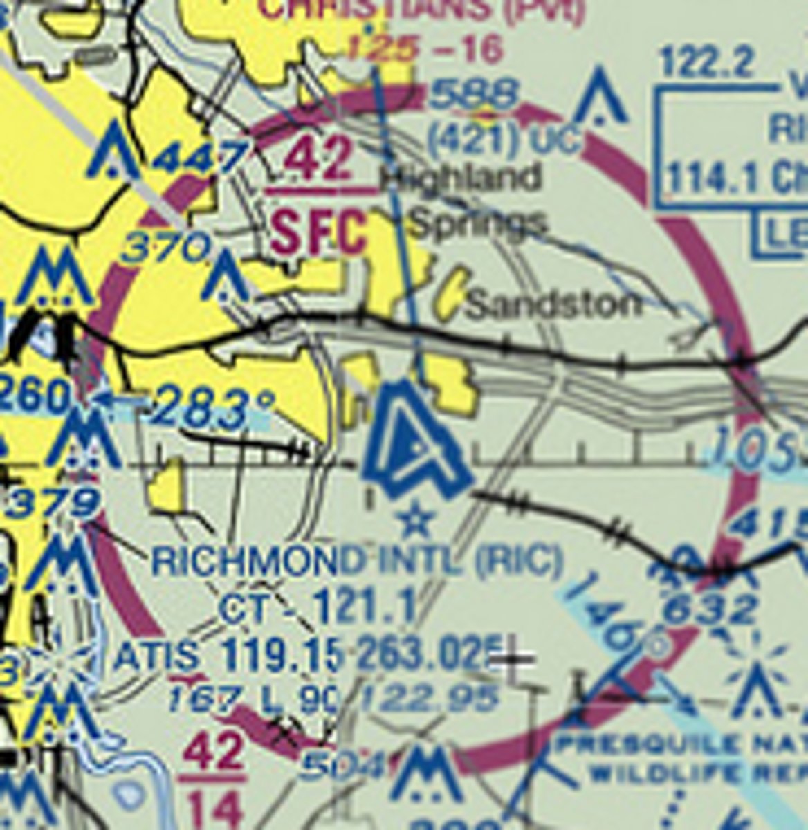
The white colored dot inside the airport/runways symbols for Richmond International indicates a ____ is located on the airfield property.
3200
The longest runway available at Williamsburg-Jamestown airport is ____ feet long

20
The field elevation at Cambridge-Dorchester airport is ____ feet MSL

2600
Class D airspace at Easton airport extends from the surface up to and including ____ feet MSL

are not available
The lack of tick marks around the symbol for Gordonsville Airport (GVE) indicates maintenance and fuel . . .
(Choose "are available" or "are not available")

are available
The tick marks around the symbol for Orange airport (OMH) indicates maintenance and fuel services ____ available
(Choose "are available" or "are not available")
122.8
The Common Traffic Advisory Frequency (CTAF) at Williamsburg airport is ____
parachute
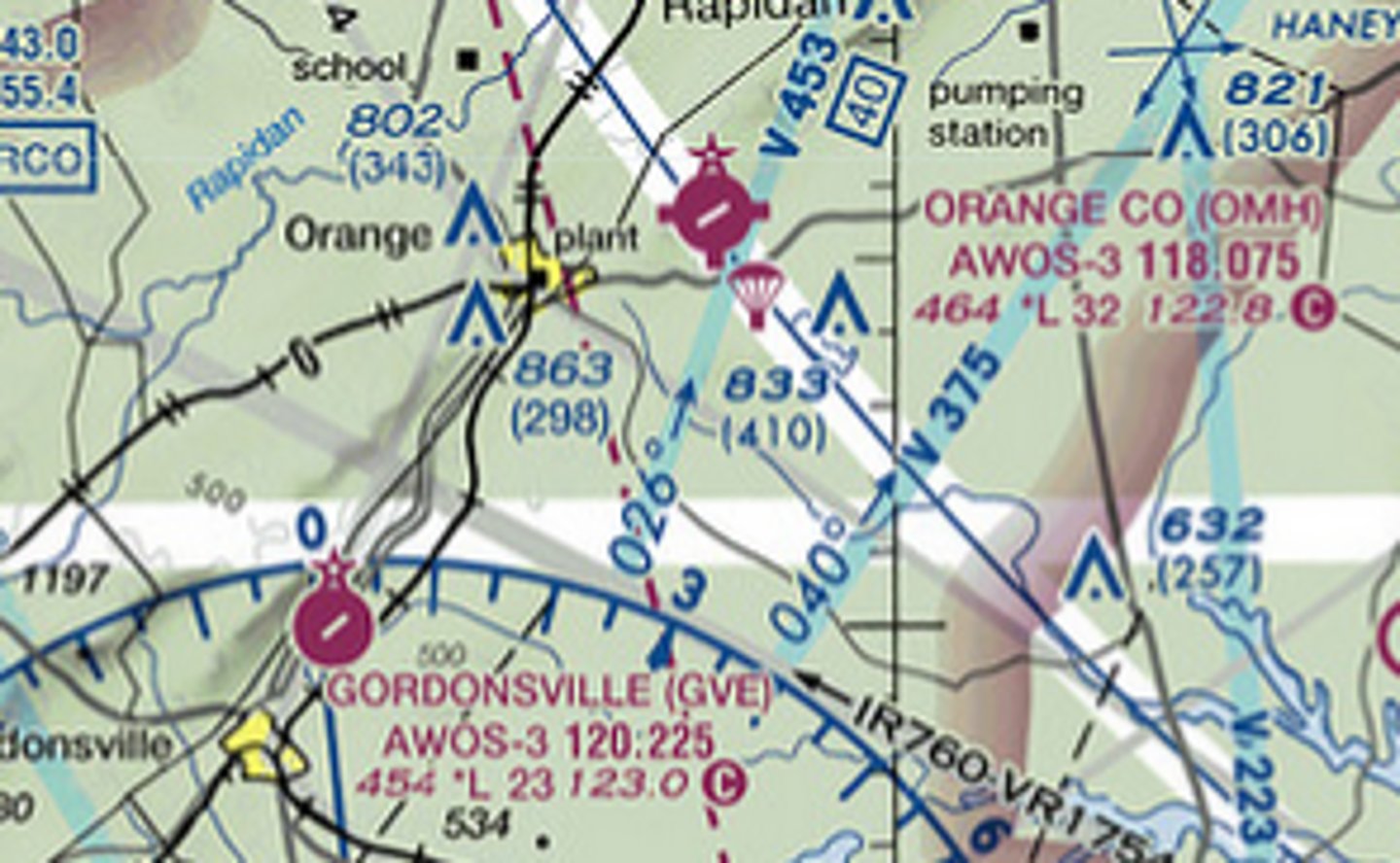
The symbol just SouthEast of Orange Country airport indicate ____ activity occurs at the airfield.

133.325
The frequency to receive the automatic weather observation at KPTB airport is ____
not continuous
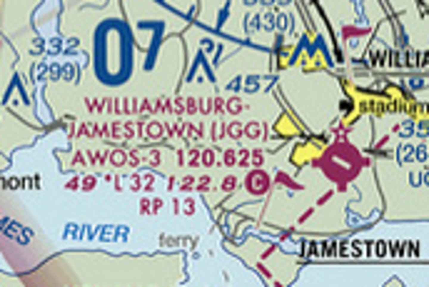
Runway lighting is indicated by either L or *L in the airport data. At night, the runway at Williamsburg Airport has . . .
[no lighting]
[not continuous lighting]
[not continuous lighting]
![<p>Runway lighting is indicated by either L or *L in the airport data. At night, the runway at Williamsburg Airport has . . .</p><p>[no lighting]</p><p>[not continuous lighting]</p><p>[not continuous lighting]</p>](https://knowt-user-attachments.s3.amazonaws.com/6996956c-bbf9-4769-80ee-50f6c61c4d11.jpg)
continuous
Runway lighting is indicated by L or *L in the airport data. At night, runway lights at Potomac Airfield and Hyde Airfield are . . .
-continuous
-not continuous
Military Operations Area
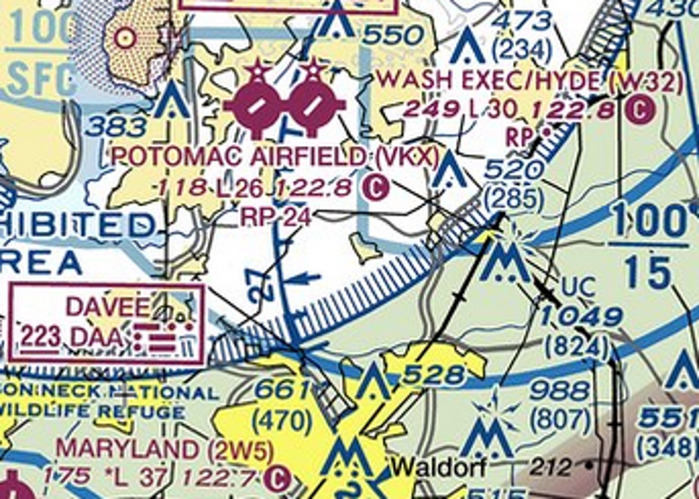
The airspace to the NorthWest of Stafford airport has a magneta hatched boundary. This indicates it is a ____ ____ Area.

right
(Note: this chart excerpt is old. KRMN is now left traffic for 15 and 33.)
The magnenta text "RP15 indicates a ____ traffic pattern for runway 15 at Stafford
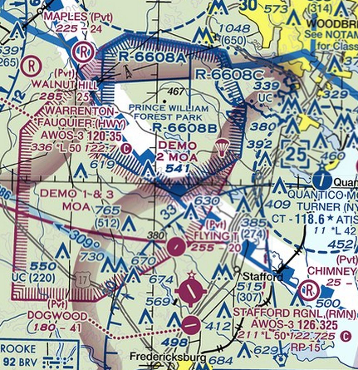
right
Potomac Airfield has runway orientation 6-24. The chart data indicates ____ traffic for runway 24
[left] / [right]
![<p>Potomac Airfield has runway orientation 6-24. The chart data indicates ____ traffic for runway 24</p><p>[left] / [right]</p>](https://knowt-user-attachments.s3.amazonaws.com/ee74bae7-ea20-4eef-a4f9-bcdb1b8bd309.jpg)
left
Potomac Airfield has runway orientation 6-24. Because text on the sectional reads "RP24" but not "RP6" the traffic pattern for runway 6 uses ____ turns.
2000
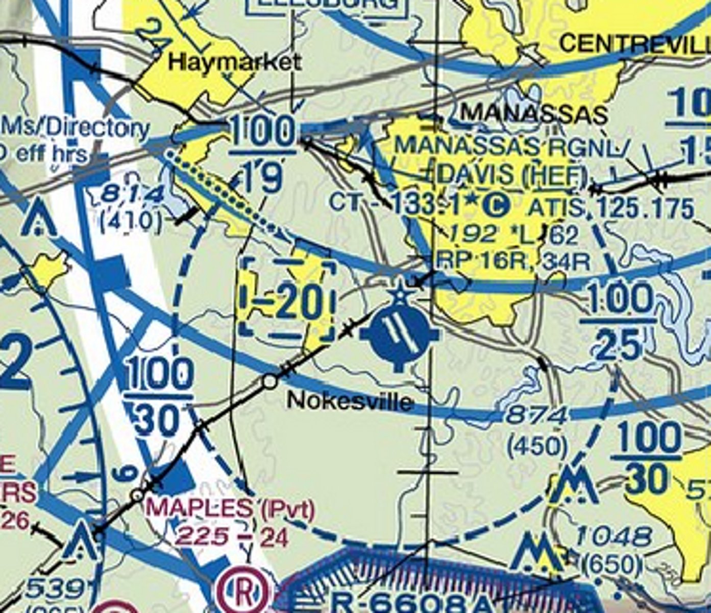
The blue text reading "-20" next to Manassas Regional Airport indicates that Class D airspace extends from the surface up to but not including ____ feet MSL
2500
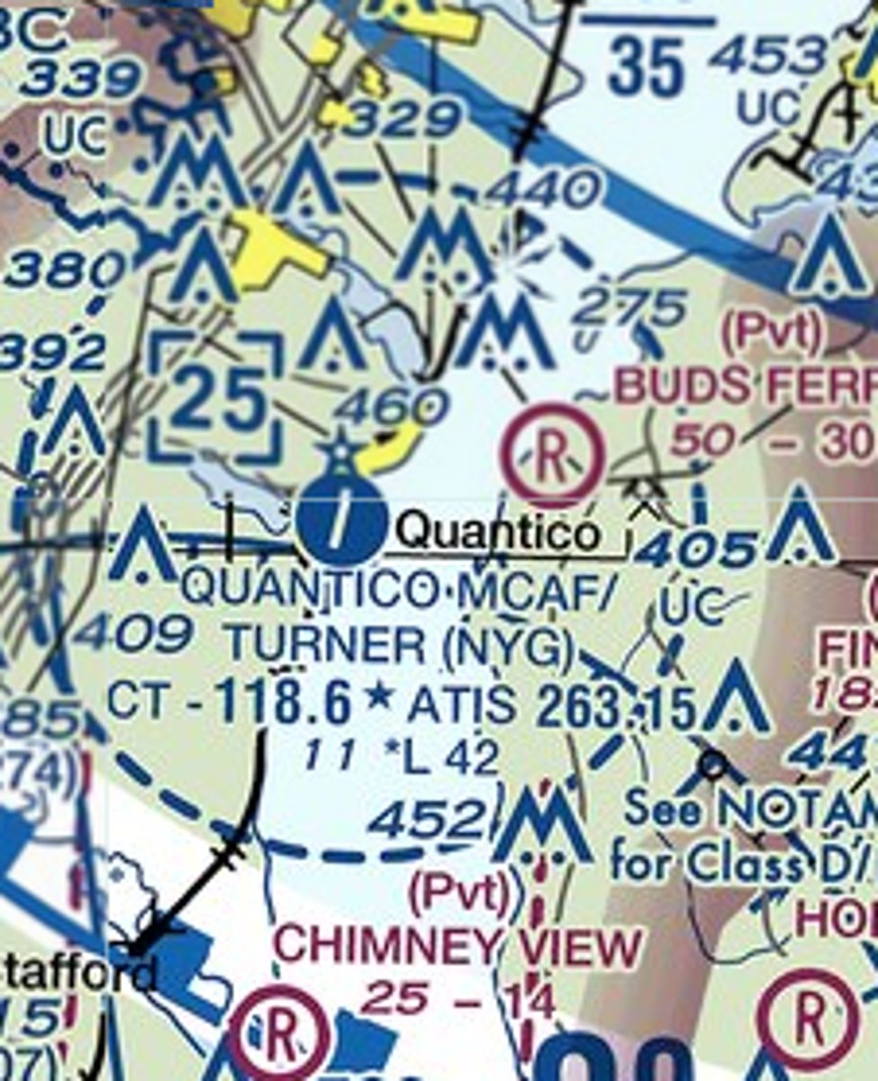
The blue text reading "25" next to Quantico Marine Corps Air Station indicates Class D airspace extends from the surface up to and including ____ feet MSL
KPRO
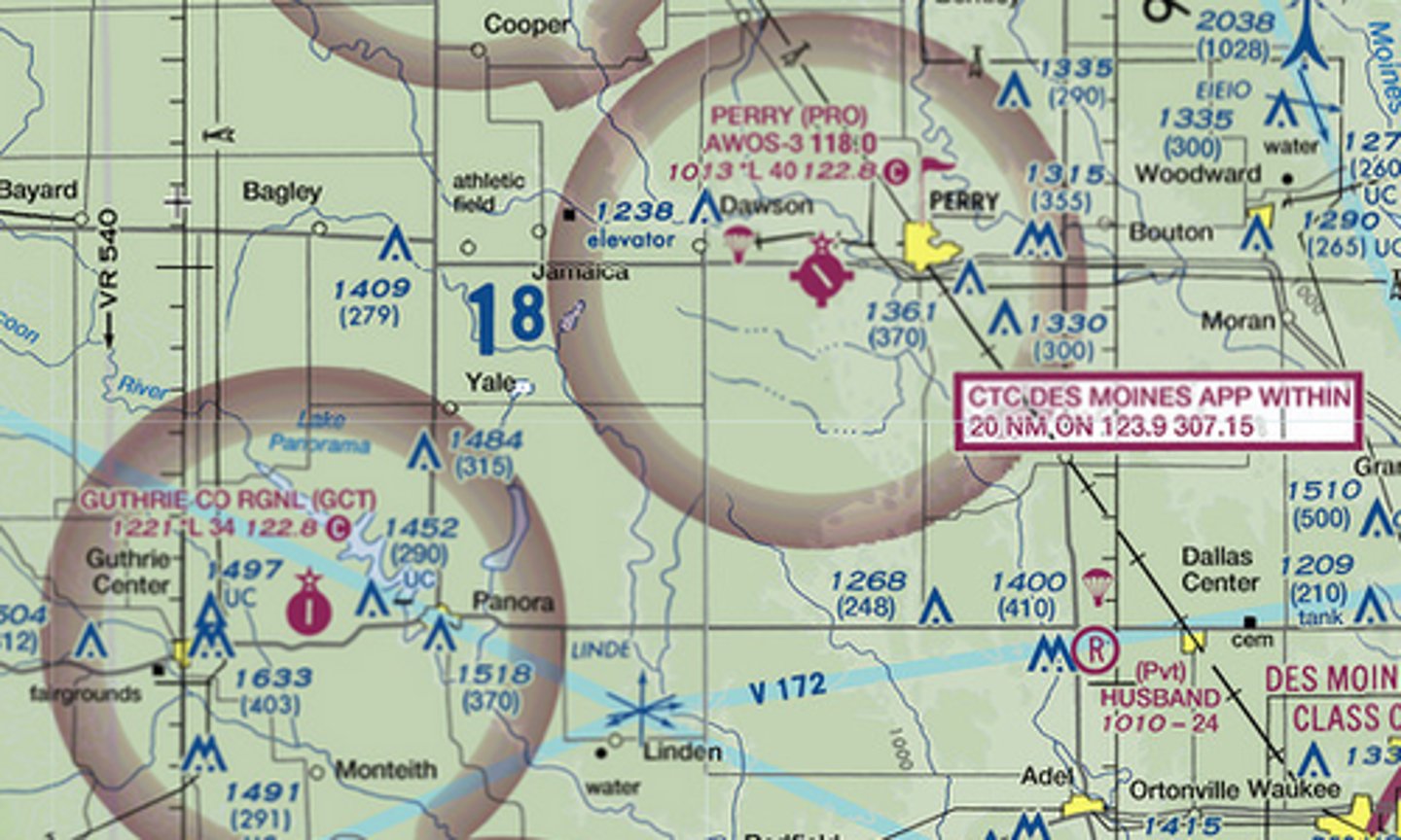
Which airport is a better choice for a fuel stop: KGCT or KPRO?
quadrangle
The large blue "20" figure indicates terrain and towers reach up almost to 2000 feet MSL within the ____
sunrise to sunset
Runway lights at Anita-Burke Airport shine . . .
[sunrise to sunset] / [when activated]
![<p>Runway lights at Anita-Burke Airport shine . . .</p><p>[sunrise to sunset] / [when activated]</p>](https://knowt-user-attachments.s3.amazonaws.com/958afb85-a974-4c00-ad46-fb8a7ed49e8b.jpg)
hard
The runway surface at KGCT is ____
[hard] / [soft]
![<p>The runway surface at KGCT is ____</p><p>[hard] / [soft]</p>](https://knowt-user-attachments.s3.amazonaws.com/f6b5ea9c-74ae-4e7a-9ebb-64b1d7c758cf.jpg)
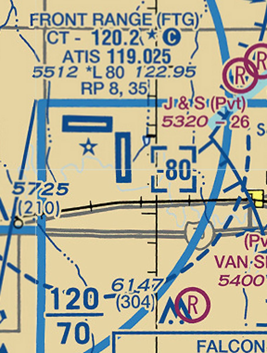
119.025
To receive recorded weather information prior to landing at Front Range airport use frequency ____
133.1
The control tower frequency for Manassas Tower is ____

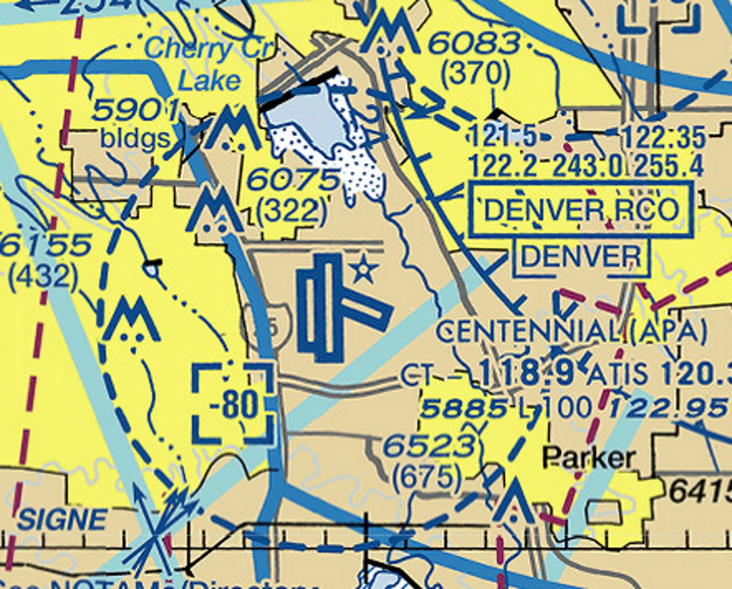
D
An aircraft flying overhead Centennial Airport at 7800 feet MSL is flying in Class ____ Airspace
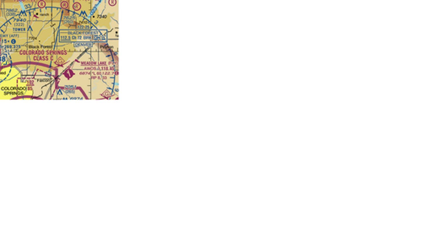
Black Forest
The graphic shows a hexagon at the center of a blue compass rose. This VOR is named . . .
Class E
An aircraft overhead Salisbury Airport at 4200 feet MSL is in ____ airspace
[Class B] / [ Class C] / [Class D] / [Class E]
![<p>An aircraft overhead Salisbury Airport at 4200 feet MSL is in ____ airspace</p><p>[Class B] / [ Class C] / [Class D] / [Class E]</p>](https://knowt-user-attachments.s3.amazonaws.com/3d12e4b3-166f-41e8-b50a-d26357181e0a.jpg)
0' AGL
The airspace extensions leading NE and SW from Salisbury Airport Class E airspace from ____ to 14,500 feet MSL
[0' AGL] / [700' AGL] / [1200' AGL]
![<p>The airspace extensions leading NE and SW from Salisbury Airport Class E airspace from ____ to 14,500 feet MSL</p><p>[0' AGL] / [700' AGL] / [1200' AGL]</p>](https://knowt-user-attachments.s3.amazonaws.com/4c22a725-2fca-4e98-86d5-6cee6ff00e3a.jpg)
TAC Chart
The white rectangle shown on this sectional chart indicates more detail for the enclosed area is shown on a ____
-TAC Chart
-Class C Chart
-WAC Chart
latitude
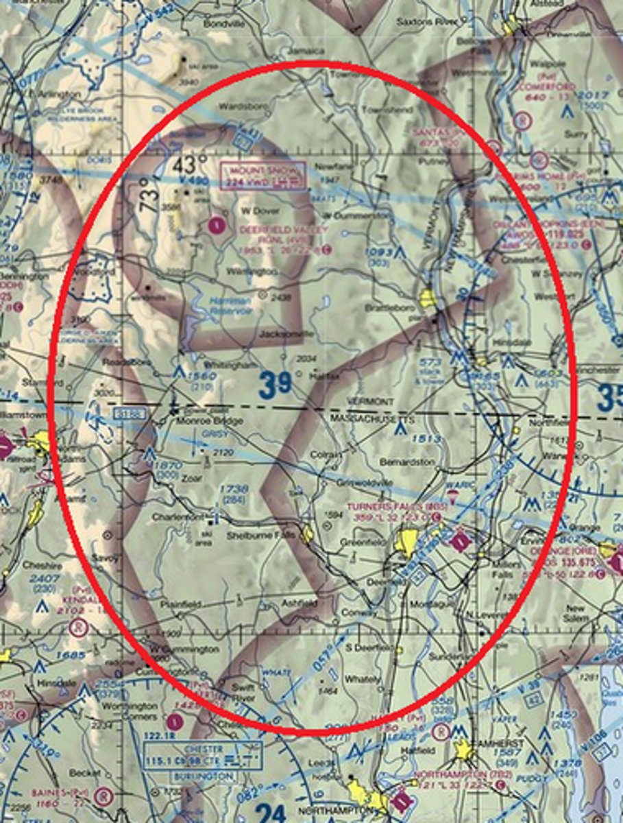
The bottom edge of the circled quadrangle marks 42 degrees North ____
-latitude
-longitude
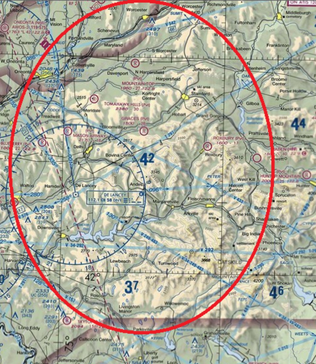
yes
Is a 5,500 feet MSL cruise altitude high enough to clear all terrain and towers in the circled quadrangle?
[yes] or [no]
![<p>Is a 5,500 feet MSL cruise altitude high enough to clear all terrain and towers in the circled quadrangle?</p><p>[yes] or [no]</p>](https://knowt-user-attachments.s3.amazonaws.com/408290b6-176a-4bee-b6b7-c552a986739e.jpg)
longitude
The left edge of the circled quadrangle marks 73 degrees East ____
[latitude] / [longitude]
![<p>The left edge of the circled quadrangle marks 73 degrees East ____</p><p>[latitude] / [longitude]</p>](https://knowt-user-attachments.s3.amazonaws.com/4648f2c5-20c2-46b5-98a6-b43bc0273497.jpg)
no
Is 3,500 feet MSL cruise altitude high enough to clear all terrain and towers in the circled quadrangle?
-yes
-no
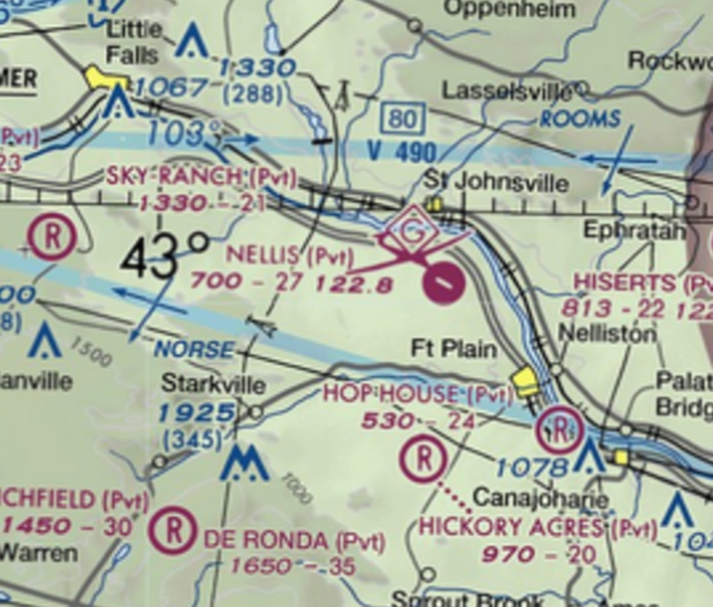
glider
The symbol for Nellis airport indicates there may be ____ activity
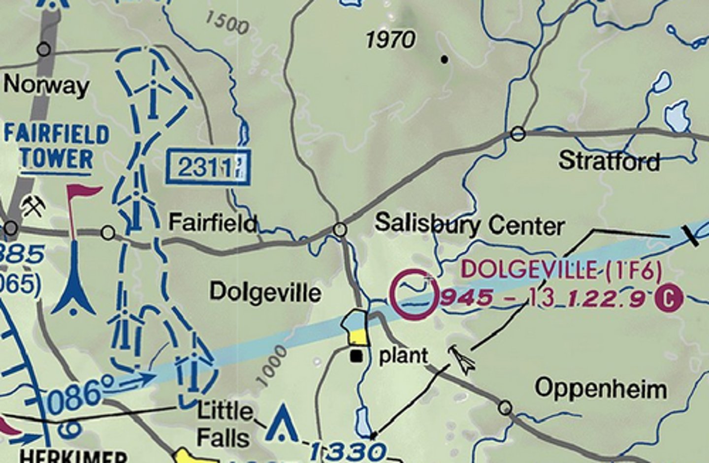
False
True or False? A rotating beacon is installed at Dolgeville airport?
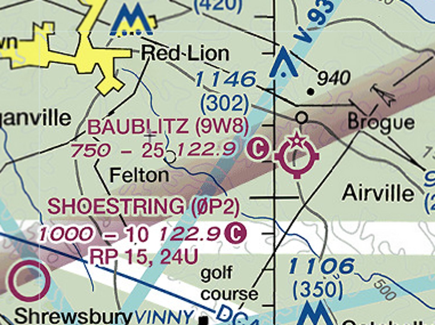
True
True or False? A rotating beacon is installed at Baublitz airport?

1000
The longest runway at Shoestring Airport is ____ feet long
TRSA
The solid gray airspace boundaries near Harrisburg International, Capital City Airport and Carlyle Airport indicate a . . . .
[Class C Airspace] / [Class B Airspace] [TRSA] / [Class E Airspace]
![<p>The solid gray airspace boundaries near Harrisburg International, Capital City Airport and Carlyle Airport indicate a . . . .</p><p>[Class C Airspace] / [Class B Airspace] [TRSA] / [Class E Airspace]</p>](https://knowt-user-attachments.s3.amazonaws.com/51e6647c-ee70-47dd-97c3-53540d7982d2.jpg)
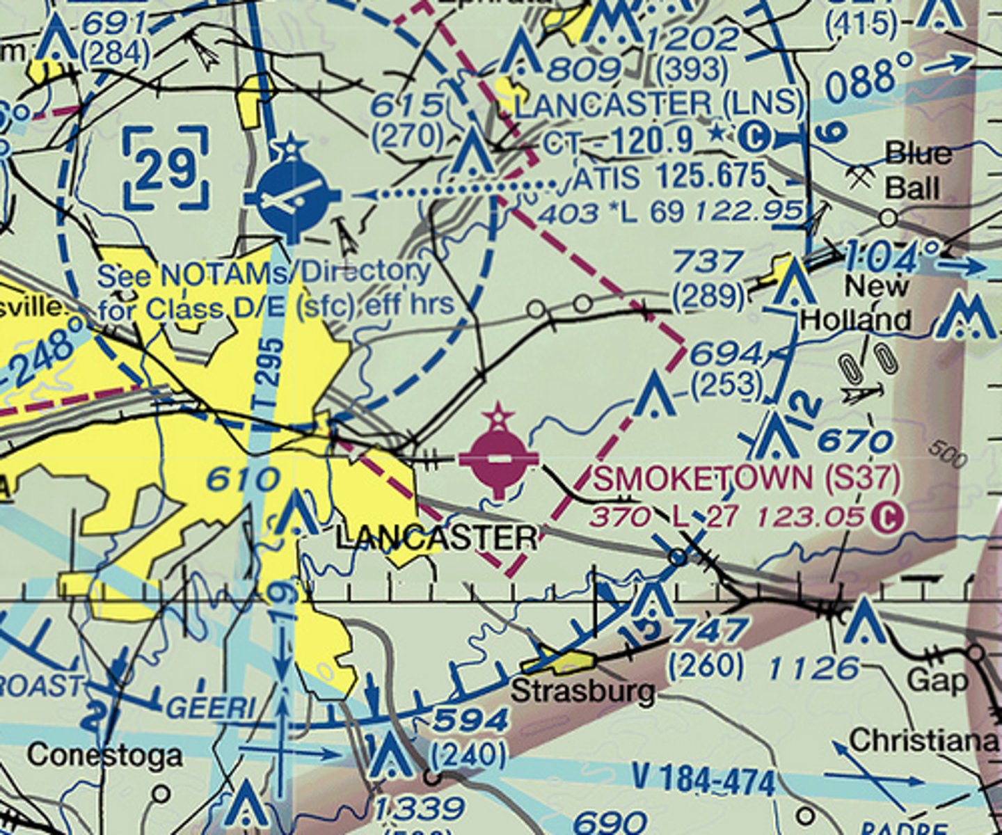
120.9
The control tower frequency for Lancaster airport is ____

not shown here
(It can be read on the margins of the sectional chart, or in the Chart Supplement book, or obtained online or from a GPS database.)
The ground control frequency for Lancaster airport is . . .
[120.9] / [125.675]
[122.95] / [not shown here]
![<p>The ground control frequency for Lancaster airport is . . .</p><p>[120.9] / [125.675]</p><p>[122.95] / [not shown here]</p>](https://knowt-user-attachments.s3.amazonaws.com/5d6d36a8-4220-41e0-b33e-a4149ac79010.jpg)
the surface
Class D airspace at Lancaster airport begins at:
[the surface] / [403 feet AGL]
[700 feet AGL] / [2900 feet MSL]
![<p>Class D airspace at Lancaster airport begins at:</p><p>[the surface] / [403 feet AGL]</p><p>[700 feet AGL] / [2900 feet MSL]</p>](https://knowt-user-attachments.s3.amazonaws.com/8ea25d72-eaca-457b-953c-129b0cc8c652.jpg)
Class E Airspace
When the control tower closes at Lancaster airport, the Class D airspace inside the dashed blue circle changes to . . . .
[Class C Airspace] / [Class E Airspace]
[Class G Airspace]
![<p>When the control tower closes at Lancaster airport, the Class D airspace inside the dashed blue circle changes to . . . .</p><p>[Class C Airspace] / [Class E Airspace]</p><p>[Class G Airspace]</p>](https://knowt-user-attachments.s3.amazonaws.com/b7e500fd-833b-411d-a61a-0af88780001b.jpg)
370
(i.e. down to the surface)
When the control tower is open at Lancaster airport, the Class E airspace over Smoketown airport extends down to ____ feet MSL
700
A fading magenta airpace boundary fades into more restrictive airspace. Outside the boundary Class G airspace extends to 1200' AGL with Class E above. Inside the boundary Class G airspace extends to ____ feet AGL
700' AGL
Class G airspace overhead Mifflintown airport begins at the surface and extends to
[700' AGL] / [1200' AGL]
[1545' AGL] / [10,000' AGL]
![<p>Class G airspace overhead Mifflintown airport begins at the surface and extends to</p><p>[700' AGL] / [1200' AGL]</p><p>[1545' AGL] / [10,000' AGL]</p>](https://knowt-user-attachments.s3.amazonaws.com/ed5f6075-c7c4-4747-ac05-0960b3d1517a.jpg)
1200' AGL
Class G airspace overhead Fox private airport begins at the surface and extends to
[700' AGL] / [1200' AGL]
[1730' AGL] / [10,000' AGL]
![<p>Class G airspace overhead Fox private airport begins at the surface and extends to</p><p>[700' AGL] / [1200' AGL]</p><p>[1730' AGL] / [10,000' AGL]</p>](https://knowt-user-attachments.s3.amazonaws.com/6c417a12-01db-49f5-88ed-e5db6fe4e46d.jpg)
G
An aircraft flying at 4000' MSL over Kingman Airport is in Class ____ airspace
[G] / [E]
[D] / [C]
![<p>An aircraft flying at 4000' MSL over Kingman Airport is in Class ____ airspace</p><p>[G] / [E]</p><p>[D] / [C]</p>](https://knowt-user-attachments.s3.amazonaws.com/85ea29cb-775a-46e3-a182-6e6b0af493fc.jpg)
6800
The longest runway at Kingman Airport is ____ feet long
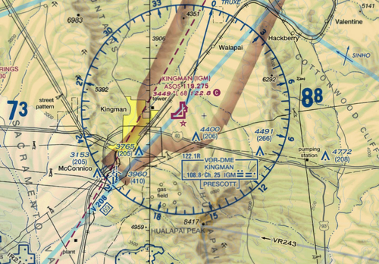
VOR
What navigation aid is located on the surface of Kingman Airport?
[NDB] / [VOR]
[LOC]
![<p>What navigation aid is located on the surface of Kingman Airport?</p><p>[NDB] / [VOR]</p><p>[LOC]</p>](https://knowt-user-attachments.s3.amazonaws.com/5e0067de-4ad7-4eda-a618-2c4b1e7caf40.jpg)
983
The dashed magenta line over Needles Airport indicates that Class E airspace may begin at ____ feet MSL
[5000] / [1983]
[985] / [50]
![<p>The dashed magenta line over Needles Airport indicates that Class E airspace may begin at ____ feet MSL</p><p>[5000] / [1983]</p><p>[985] / [50]</p>](https://knowt-user-attachments.s3.amazonaws.com/d5ddacac-f4b6-49ba-ae83-e7c5f9e01926.jpg)