history of our planet week 8
1/43
Earn XP
Description and Tags
ice age
Name | Mastery | Learn | Test | Matching | Spaced |
|---|
No study sessions yet.
44 Terms
Glacial-interglacial cycle:
Evidence of the quaternary glacial-interglacial is strong
Characterised by the waxing and waning of vast, continental ice sheets
Quaternary stratigraphy:
‘stratigraphy’ – process of assigning order to geological, climatic, and environmental events
Researchers have identified series of ice ages based of glacial geomorphology
Different names in different parts of the world
Marine isotope stages (MIS) – a universal ‘quaternary timeline’ based on oxygen isotope records from deep sea sediments
A note on terminology:
Glacial and interglacial periods have different names across the world
E.g.:
Current interglacial (MIS 1): Holocene (EU/US); Flandrian (UK)
Last glacial (MIS 3): Devensian (UK); weichselian (EU); wisonsinan (US)
Last interglacial (MIS 5e): ipswichian (uk); eemian (EU); Sangamonian (us)
‘best analogue’ interglacial (MIS 11): hoxnian (UK); holsteinian (EU); pre-illonian (US)
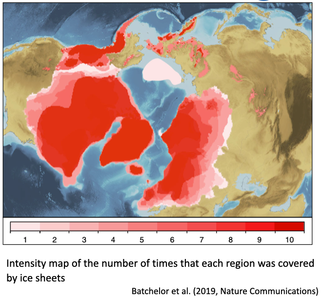
Quaternary ice sheets: 1
Europe (british, scandanavian)
North America (Laurentide, cordilleran)
Russia (Barents, kara)
Greenland
Increased global ice volume
Lower sea levels
Quanternary ice sheets: 2
Maximum extent of ice sheets through the quaternary
Each glacial left behind ‘evidnece’: glacial geomorphology, till, erratics etc
‘law of superpositions’: within wider geological context
Allow us to ‘date’ the evidence and form glacial stratigraphy for each area
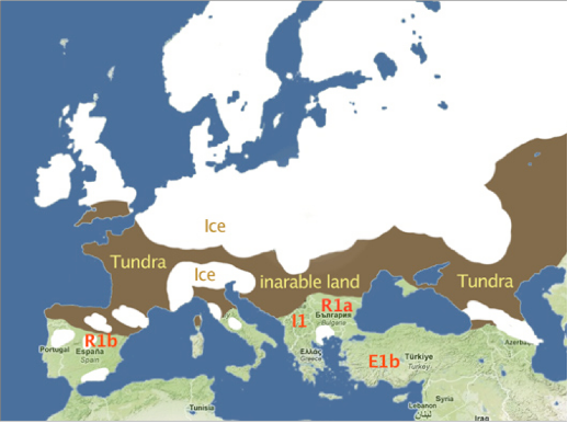
Last glacial ice sheets in Europe:
European continent at the end of the last glacial period
ice sheet covering most of northern Europe
Extensive glaciation in alpine regions as far south as southern spain, Greece, and Georgia (Morocco?)
18th and 19th C – glacial geomorphological evidence led to glacial-interglacial cycle theory
British ice sheet:
Maximum extent of british-irish ice sheet during Devensian glacial
Last glacial maximum (LGM) c. 21,000 years ago
Covered Scotland, Ireland, wasles, and northern England
800,000km ^3
Up to 1.5km thick
One third size of modern day Greenland
Significant pressure system over ice sheet
Extent of glaciation is contected
Saunton sand, north devon – pink granite erratic from Scotland
Small glaciers on Exmoor?
Independent mini-ice sheet on Dartmoor?
North American ice sheets:
two independent ice sheets either side of the continental divide: rocky mountains
1. Laurentide ice sheet: C. 3km thick, 33 million km^3
2.Cordilleran ice sheet: Merged with Laurentide during LGM
Combined = 1.5 x modern Antarctic ice sheets
Research focus – on north Atlantic region

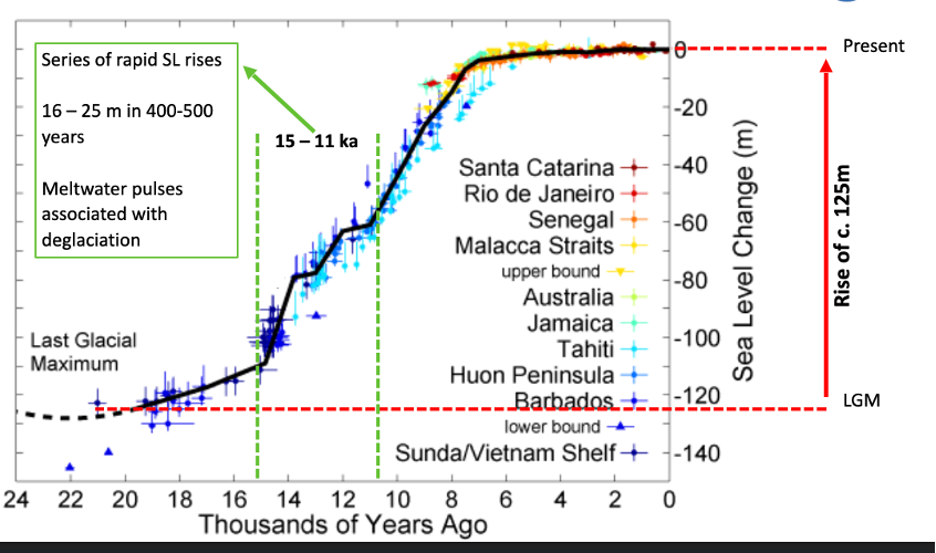
Sea level in the quaternary:
Eustatic sea level change: global average sea level fluctuates with global ice volume
Sea level closely correlated with glacial-interglacial cycle
Sea level at LGM c. 120/125m lower than present
Crustal rebound following deglaciation can cause isostatic (localised) sea level rise
Compounds anthropogenic sea level rise
Geomorphological and sedimentological evidence for past sea level change
Wave cut platforms, raised beach deposits, marine fossils
Hope’s nose peninsula, south devon
Huon peninsula, papua new giunea
Sea level since the LGM:
LGM c. (20-25k years ago) – sea level 125m lower
Significant effect on coastline compared to modern day
Land-bridges – dispersal of plants, animals, humans
end of the last glacial: causes:
Two major driving factors:
1. Increased summer insolation at higher northern latitudes
2. Increase in atmospheric CO2 from 190 to 280ppm:
Increased seasonality
Reduce ice volume, sea-ice cover
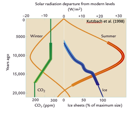
end of the last glacial: causes: 1. Increased summer insolation at higher northern latitudes
Obliquity (tilt) reached maximum
Precession (wobble) brough earth closer to sun
end of the last glacial: causes: 2. Increase in atmospheric CO2 from 190 to 280ppm:
Ocean degassing
Biomass feedback
The end of the last glacial: structure:
Greenland ice-core (GISP2) temperature record
No smooth transition from LGM to Holocene
Punctuated by series interstadials, stadials
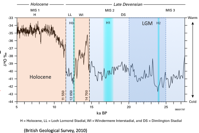
The end of the last glacial: deglaciation:
‘late glacial’ characterised by relatively rapid deglaciation of northern hemisphere continental ice sheets
Beginning of the Holocene, just a small ice cap on Scotland’s Trossachs and highland range
Glacial re-advance during the loch Lomond stadial, also known as the Younger Dryas
Landscape change in the quaternary:
Periglacial (edge of ice) landscapes and processes
Extensive permafrost
Dramatic shifts In biome range:
Vegetation, Animals, humans (not just h. sapiens)
The end of the last glacial: biome shifts:
temperate biomes expand northward
Glacial ‘refugia’
Tundra contracts
Implications for fauna (including humans)
The end of the last glacial: sea level rise:
Doggerland: low lying ‘country’ stretching from Britain to Netherlands
Sea level rise at the end of last glacial began flooding
Submerged c. 8200 years ago (‘8.2 kyr event’)
Archeology: mammoth, lion, human tools and weapons
Bathymetric studies: vast flood-plains of europes major rivers
Fertile land, prime for human habitation
The end of the last glacial: British isles:
Lake Windermere, Cumbria
Late-glacial ‘type site’
Coope and pennigton (1977)
Changing sedimentology indicated change in geomorphological processes in catchment (ice action, organics)
Found in lake sediments across NW Europe – sharp transitions, indicates rapid climate change
Beetle records provided temperature reconstruction: sharp temp increases, c. 1*C per decade, rapid climate change
The end of the last glacial: terminology
north America – the Devensian is known as the wisconsinan
key: the overall pattern of glacial-interglacial transition is very similar across the northern hemisphere
the north Atlantic:- regional focus on north Atlantic region:
historic bias due to distribution of researchers in NW Europe
genuine driver of global change – teleconnections
the north Atlantic: - potential drivers for change:
atmospheric circulation change, via north Atlantic oscillation (NAO)
oceanic circulation change, via Atlantic meridional overturning circulation (AMOC) – not the same as ‘Atlantic multidecadal oscillation’ – AMO
the north Atlantic: NAO:
air pressure gradient between:
subpolar (Icelandic) low
subtropical (Azores) high
influences strength and position of north Atlantic jet stream, northern westerlies
modulates patterns of zonal and meridional (i.e. latitudinal and longitudinal) heat and moisture transport
affects changes in temperature and precipitation across region
positive = strong gradient, jet stream forced north
negative = weaker gradient, enhanced trough-peak-trough in jet stream
the north Atlantic: AMOC:
northward flow of warm, salty surface water, includes the gulf stream
southward flow of colder, deep water, part of the thermohaline circulation system
transport of heat (energy) from tropics and southern hemisphere, to north Atlantic, where heat is lost to atmosphere
impacts on global climate system: sea surface temperature, arctic sea ice, moisture supply
potential for disruption during deglaciation
the north Atlantic: in the quaternary: 1
glacial and interglacials punctuated by a series of interstadials and stadials
millennial-scale abrupt climatic shifts
dansgaard-oeschger events: very common in glacials, weak in interglacials
o 25 events during last glacial, 120k years ago
In the northern hemisphere, characterised by rapid warming to interglacial temperatures, then slower cooling
5-8*C increases in c. 40 years in Greenland
In southern hemisphere, slow warming and smaller temperature fluctuations
Suggestion of periodicity (c. 1470 years) – debated
Heinrich events: Occur in cold spells preceding some D-O events, 6 identified in late quaternary, Icebergs break off from ice sheets, Transport terrestrials, minerogenic ‘ice rafted debris’ into north Atlantic, deposited on ocean floor
the north Atlantic: in the quaternary:2
Drivers of change – link between dansgaard-oeschger and Heinrich events
Still largely uncertain
Difference between northern and southern hemisphere response, although globally synchronous
Internal forcing? Changes in north Atlantic circulation, freshwater pulses, thermohaline, Ice sheet dynamics: binge-purge cycle, size of oce sheets (control on atmospheric, oceanic circulation)
External forcing: Solar activity, orbital cycles – periodicity
Deglaciation in north America:
Proglacial lake formed along margin of Laurentide and cordilleran ice sheets
Glacial lake Agassiz: At maximum extent covered most of Manitoba, Ontario, and part of Quebec, lake Winnipeg modern remnant
staged but catastrophic collapse
one single collapse evet resulted in global sea level rise of 20-40cm
freshwater into north Atlantic – potential global climate impact
summary: the quaternary in the northern hemisphere:
historical focus on quaternary climate and environmental change in northern hemisphere (nw europe, north America)
continental ice sheets dominate landscapes
several important climate-system components:NAO, AMOC
driver of change?
Teleconnections?
Important to consider global climate system as whole, vital components else where: Tropics, Southern hemisphere
Quaternary across the world:
quaternary history of the southern hemisphere is very different
North characterised by was and wane of continental ice sheets
Patagonian ice sheet
Glaciers elsewhere:
New Zealand
Tasmania
East Africa (mt. Kilimanjaro, mt. Kenya, Rwenzori range)
Papua new guinea
Antarctica, sub Antarctic islands
Spatial patterns in quantity of quaternary palaeo-records: Historical bias, Geographical distribution of land
Effort to expand this spatial network, to answer crucial questions about earth climate system
The southern ocean:1
Ocean south of 60*S latitude
Antarctic convergence: Cold water meets warmer water, High productivity
Longest and strongest ocean current on earth (Antarctic circumpolar current, ACC)
Inter basin exchange between pacific, Atlantic, Indian
Relatively poorly understood
The southern ocean: 2
Global ocean is largest carbon reservoir in earth system
Co2 rich deep water
80% of earths deep water resurfaces in southern ocean
Southern westerlies create strongly divergent surface flow over southern ocean, promoting upwelling of deep water
Southern westerly wind belt:
Northern westerlies, land masses, season gyres
Southern westerlies, uninterrupted, strongest time-average winds on the world
Strength and position of SWWB determines whether southern ocean acts as a source or sink of atmospheric co2
Value in reconstructing past variability in SWWB
Southern annular mode (SAM):
Pressure gradient – similar to NAO
Positive SAM – strong lows over Antarctica, stronger high s further north
Linked to increased upwelling in the s. ocean, increased atmospheric co2
Recent years has seen increasingly positive SAM – natural, anthropogenic?
Shift in strength and position of SWWB
Terrestrial records, less ice – but not much land
Current research focus: new Zealand, Patagonia, Antarctic peninsula
The monsoonal systems:
Seasonal reversal of wind direction
Dramatic seasonal changes in precipitation patterns
Summer monsoon provide 90% of Asian precipitation
Complex: 3 x Asian monsoons, African monsoon, south American monsoon
Loess deposits:
Fine grained, wind blown sediments – associated with strength of Asian monsoon
Biggest deposits are found in Loess Plateau, middle reaches of yellow river, north china
Covers c. 450,000km^2 , twice the size of the UK
10-50m thick are common, forming near continuous drape over landscape – deepest 505m
Winds are strong in glacials (thick deposits), weak in interglacials (palaeosol formation
Sedimentological changes reflect glacial-interglacial cycle (i.e. marine isotope stages – MIS)
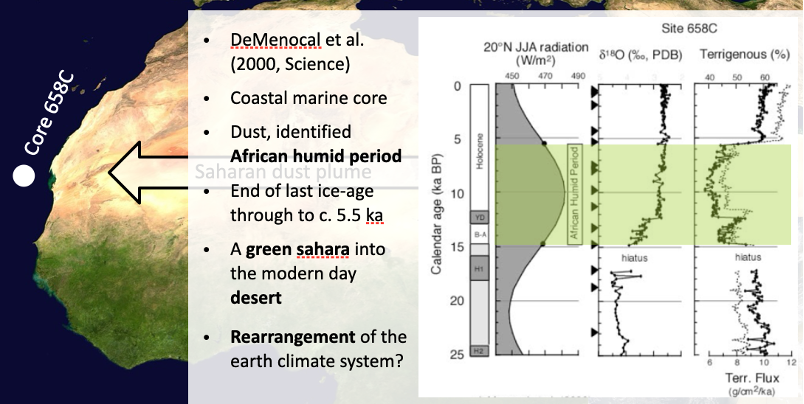
A green Sahara:
Archaeological evidence in Sahara that environment was very different in recent past, within Holocene
Abundant tropical fauna and flora (e.g. giraffes, elephants, baboons and other primates)
Palaeolithic cave art shows animals
Dwarf crocodiles still present in isolated southern Sahara water holes
Asian ice cores:
Antarctic/ Greenland records valuable but polar only
Asian/ sub tropical ice cores improve understanding of earth climate system
Four ice caps on Tibetan plateau (aka, the ‘third pole’)
2017: gulyia ice cap, oldest ice core from non polar region, c. 600,000 years old. Asian monsoonal reconstruction
Asian speleothems:
Several key speleothem records from caves across Asia/ subtropics
Potentially high resolution records
Stable isotope records can inform understanding of Holocene/ quaternary climate dynamics (e.g. Asian monsoon)
Dongge and hulu cave speleothem records amongst most famous, both in China
Dongge: solar facing, north Atlantic (Heinrich events?)
El nino – southern oscillation (ENSO):
Poorly understood periodic variation in tropical pacific wind, ocean currents
El nino – warming phase, high in western tropical pacific
La nina – cooling phase, low in western tropical pacific
Climatically and economically vital
Porites corals:
Living stony corals can provide records c. 200 years
Like tree rings can be combined – live and fossil
Delta 18O record = SST ENSO?
Summary – quaternary across the world:
Very different quaternary when compared to northern hemisphere:
Lack of contintenal ice sheets
Potentially imporat climate- system components about which very little is known:
SAM and SWWB: Climate change and southern ocean as carbon store/ sink
Asian/ African monsoon
ENSO
Valuable new records and climate proxies being developed – more needed