GEO1002
 Call Kai
 Learn
Learn Practice Test
 Spaced Repetition
 Match
Match Flashcards
 Knowt Play
 Podcast
1/109

There's no tags or description
Looks like no tags are added yet.
Name | Mastery | Learn | Test | Matching | Spaced | Call with Kai | Chat |
|---|
No analytics yet
Send a link to your students to track their progress
110 Terms
metadata
data describing other data (when, in what coordinate system, etc.)
main properties of geographic phenomena
can be named and/or described (what?)
can be georeferenced (where?)
have a timestamp or interval (when)
types of geographic phenomena
fields, objects and boundaries
Fields
continuous ←→ discrete
all points in a certain spatial domain have a value
objects
location, shape, size, orientation
have a specific geometry
boundaries
crisp or fuzzy
data values
nominal
ordinal
interval
ratio
nominal data values
descriptive, providing a name or an identifier
ordinal data values
values can be ordered
interval data values
quantitative values that allow for some simple arithmetic operations like algebraic sum
example: T, pH
ratio data values
continuous numeric, can perform all arithmetic operations, including multiplication and division
example: distance, area, weight
spatial referencing comprises
definitions, physical/geometric concepts, tools
to describe the geometry (and motion) of objects near the earth’s surface
geodesy
discipline that deals with the Earth’s geometric shape, it’s orientation in space, and it’s gravitational field
spatial referencing
geoid: vertical datum
ellipsoid: horizontal datum
both approximate the real surface of the Earth
the Geoid
height reference taken by mareographs (tide gauges), avaraged over long period
many different local height references exist, based on different mareographs
virtual datum -levelling lines→ levelling network with benchmarks
the Ellipsoid
mathematical surface used as reference for horizontal coordinates
defined by:
semi-minor (b) and semi-major (a) axes
flattening (f)
eccentricity
both local and global ellipsoids
triangulation network with monumented points for convenience
approximate Earth radius (sphere)
6365 km
approximate difference between Earth’s semi-minor and semi-major axes
22 km
GNSS satellites distance to Earth’s surface
20 000 km
ITRF
International Terrestrial Reference Frame
(with S: System)
catalogue of precise coordinates of certain points (stations) at a certain time
triangulation network connecting all GNSS (satellite) stations as a 3D polyhedron
WGS84 ellipsoid
used by GPS/GNSS
aligned with ITRS: differ by a few centimeters
coordinates (lat lon and h) can be derived
!!! h has no physical meaning, we still need the Geoid and it’s orthometric height H
orthometric height, ellipsoidal height, Geoid height
H = orthometric height (geoid → orthometric surface)
h = ellipsoidal height (ellipsoid → orthometric surface)
N = Geoid height (ellipsoid → geoid)
H = h - N
map projection
mathematically described operation (transformation) of how to present the Earth’s curved surface on a flat map
point(s) of contact: no distortion
map distortions grow as you move away from the point of contact
Tissot’s indicatrices
equivalent circles that get distorted in different ways depending on their position on the projected surface
map projection used in the Netherlands
EPSG:28992 & EPSG:5709 (NAP height)
shapefiles
file format for vector data + attributes
each shapefile contains exclusively one type of geometry
(consists actually of different files)
capabilities of a GIS
data capture and preparation
data management (storage and maintenance)
data manipulation and analysis
data presentation
depending on the specific application, a GIS can be seen as
a storage system for (spatial) data
a toolbox
a technology
an information source
a field of science
GNSS
Global Navigation Sattelite System
Secondary data acquisition
manual digitizing
automatic digitizing
semi-automatic digitizing
input of available digital data
manual digitizing
coordinate entry via keyboard
digitizing tablet with cursor
mouse cursor on computer monitor (heads up)
(digital) photogrammetry
automatic digitizing
scanner
semi-automatic digitizing
line-following software
spatial data acquisition process
scanning → vectorizing → post-processing (taking away the noise)
web services for geodata
WMS: web map service
merge into a single raster map
WFS: web feature service
vector based, for more comples applications
types of quality checks
positional accuracy
attribute accuracy
temporal accuracy
lineage (“history of the dataset“)
completeness
logical consistency
raster representation advantages
simple data structure
simple implementation of overlays
efficient for image processing
raster representation disadvantages
less compact
difficulties in representing topology
cell boundaries independent of feature boundaries
vector representation advantages
efficient representation of topology
adapts well to scale changes
allows representing networks
allows asy association with attribute data
vector representation disadvantages
complex data structure
overlay more difficult to implement
inefficient for image processing
more update intensive
aliasing
variation in the density of pixels → jaggedness and varying line intensity
TIN
Triangulated Irregular Network
2.5D models
no vertical triangles possible
Delaunay triangulation
for each triangle, no points are allowed inside its circumcircle
reduces number of thin/skinny triangles
(dual to Voronoi diagram)
unique if there are no 4 or more points on the same circle.
RMSE
Root-mean-square error
frequently used measure of the differences between values predicted by a model and the values observed
square root of the avarage of squared errors
sensitive to outliers!
RMSE = sqrt(SUM[ (z_predicted - z_observed)² ] / N)
DEM
digital elevation model
usually a grid
most generic term you will find
DTM
digital terrain model
sometimes class of DEMs
explicitely only terrain models
grid or TIN
DSM
digital surface model
includes also all man-made objects
grid or TIN
n-DSM
normalised DSM
difference between DSM and DTM
focussing on the non-terrain features
slope map
= gradient
maximum rate of change in elevation
magnitude of steepest tilt
very much linked to the scale of the dataaset
calculated very differently in TINs and rasters
aspect map
direction (azimuth) of the steepest tilt is the aspect
varies from 1 to 360
shaded relief map
showing how the 3D surface would be illuminated from a point light source
generally light top left
generally used to enhance the visualisation of (raster based) DEMs
alphanumeric data
integer, real, Boolean, data, varchar, blob, etc.
maintenance of GIS data
keeping the data up to date
making the data accessible and usable to (ideally) as many different users as possible
shapefiles
file format for vector data + attributes
each shapefile contains exclusively one type of geometry
consists of different files
topology is not supported
DBMS
DataBase Management System
software used to administer the database and to interact with end users, applications and the database itslf
offers a query language
takes care of data backup and recovery
can take care of concurrent usage
query
function that allows to perform CRUD operations on a database
C create
R retrieve
U update
D delete
relational model
collection of tuples (/records/rows) collected into relations (tables)
table = records having the same number and type of named fields (/attributes/columns)
attribute
defined by it’s domain (defines which type of data is allowed and it’s interval of validity)
can contain a data value or the NULL value
superkey
a set of attributes within a table whose values can be used to uniquely identify a tuple
candidate key
= minimal superkey / unique key
minimal set of attributes necessary to identify a tuple
primary key
the choice of candidate key
→ remaining candidate key(s) are alternate keys
foreign key
a set of attributes (ideally one) in table B that references a candidate key in table A
referencing table
uses foreign keys to reference referenced tables that contain the primary keys
SQL: *
wildcard = “all columns“
planar partition
no overlaps
structural incompatibility
different ways to store the “same“ data
semantic incompatibility
the same object is named in different ways in different tables
different objects are named in the same way in different tables
euclidian space
linear
flat
continuous
uniform
coordinate-based
allows measuring distances and angles
set-based space
the constituent objects to be modelled = elements (/members)
collection of elements = sets
s ∈ S: s is member of S
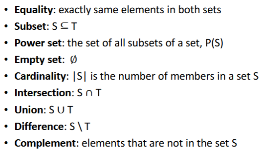
examples of sets

sets: relations and operations
topology
study of relational properties of form
→ such properties are invariant under topological transformations
→ “rubber-sheet” transformations
topological and non-topological properties
Topological:
a point is at an end-point of an arc
a point is on the boundary of an area
a point is in the interior/exterior of an area
an arc is simple
an area is open/closed/simple
an area is connected
Non-topological:
distance between two points
bearing of one point from another point
length of an arc
perimeter of an area
G = (V, E)
V: vertices, non empty set (or nodes)
E: edges, unordered pairs of linked vertices
directed <> undirected graphs
degree
number of edges connected to a node
path
sequence of connected edges
cycle
path leading to the origin after traversing at least one edge
connected (graph)
there is a path between any pair of nodes
isomorphic
with the same connectivity relationships
tree
acyclic (only one path per pair of nodes) connected graph
rooted tree
has leafs
planar graph
a graph that can be embedded in the plane such that no edges intersect
Euler’s formula in the plane
if: f - e + v = 1 → the graph is planar
dual G*
obtained by associating a node in G* with each face in G
two nodes in G* are connected by an edge if and only if their corrisponding faces in G are adjacent
a voronoi diagram is the dual G* of the corresponding TIN
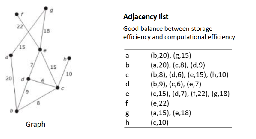
network representations
adjacency matrix
adjacency list
adjacency matrix

adjacency list
good balance between storage efficiency and computational efficiency
network algorithms
depth-first
breadth-first
Dijkstra’s
A* (A-star)
Euler 3D
if: f - e + v = 2 → the graph is planar (or 1 if you do not consider outer region face)
0-simplex
1 vertex (“point“)
1-simplex
closed finite line segment
two vertices
2-simplex
set consisting of all the points on the boundary and in the interior of a triangle whose vertices are not collinear
3 vertices
3-simplex
tetrahedron
4 vertices
n-simplex
n-dimensional polytope, convex hull of its n+1 vertices
face of n-simplex
a 0…n-simplex whose vertices form a proper subset of the n+1 vertices of S
faces of n-simplex
n+1 vertices
2^(n+1)-1 faces in total
simplical complex (SC)
a finite set of points, line segments, triangles (and their n-dimensional counterparts) having the following properties:
every face of a simplex which belongs to the SC is also belonging to the SC
the non-empty intersection of any two simplexes belonging to the SC is a face belonging itself both to S1 and S2
CW Complex
or Cell Complex
closure-finite, weak (topology)
! non simplical
shape in GIS…
does matter!
GIS = combination of geometrical and topological information
in GIS, topology plays an important role because it…
describes spatial relationships between neighbouring features
informs on the validity of a data set
enables advanced spatial analyses