[AMAERO] L2 | AERODROME DATA AND PHYSICAL CHARACTERISTICS
1/40
There's no tags or description
Looks like no tags are added yet.
Name | Mastery | Learn | Test | Matching | Spaced | Call with Kai | Chat |
|---|
No analytics yet
Send a link to your students to track their progress
41 Terms
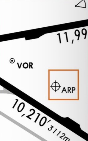
AERODROME REFERENCE POINT (ARP)
It is defined as the designated geographical (Lat and Long) location of the aerodrome and is to be reported to the aeronautical information services authority in degrees, minutes and seconds.

AERODROME REFERENCE POINT (ARP)
This should be located near the initial or planned geometric center of the aerodrome and will normally remain where first established. In reality, it is usually the center of the longest runway.
PRE-FLIGHT ALTIMETER CHECK LOCATION
One or more ________________ are required for an aerodrome. These should be located on an apron to enable an altimeter check to be made prior to obtaining taxi clearance and thus eliminate the need for stopping for that purpose after leaving the apron.
PRE-FLIGHT ALTIMETER CHECK LOCATION
Normally an entire apron can serve as a satisfactory altimeter check location. The elevation of a ____________ is given as the average elevation, rounded to the nearest meter or foot, of the area in which it is located.
3 m (10 ft)
The elevation of any portion of a pre-flight altimeter check location must be within ________ of the average elevation for that location
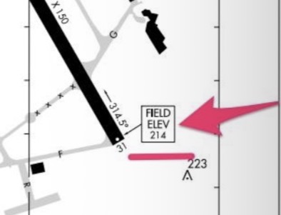
AERODROME AND RUNWAY ELEVATIONS
The aerodrome elevation at an aerodrome elevation position (the highest point of the landing area) is measured to the nearest half meter or foot. For precision runways, it is to be measured to the nearest 0.25 m or foot.
geoid
is the gravitational level of mean sea level extending continuously through the continents. It is irregular due to local gravitational disturbances, hence _____ undulations
PAVEMENT STRENGTHS
Where paved areas (runways, taxiways, aprons) are used by aircraft with maximum take-off mass greater than 5700 kg, the ______________ is reported by the aircraft classification number - pavement classification number (ACN-PCN) system.
PCN is equal to or greater than the ACN
An aircraft can safely use a paved area if the ___ is equal to or greater than the ____.
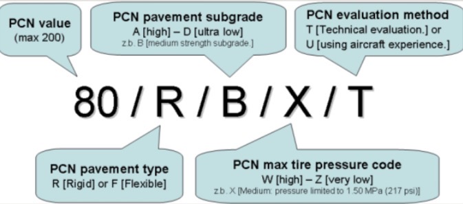
PAVEMENT CLASSIFICATION NUMBER (PCN)
is used to indicate the strength of a runway, taxiway or apron. It is of primary importance for the apron as this is where the aircraft mass will be greatest. PCN is only used for paved areas. (FOR AIRPORT)
PCN value (max 200)
[PAVEMENT CLASSIFICATION NUMBER (PCN)]
![<p>[PAVEMENT CLASSIFICATION NUMBER (PCN)]</p>](https://assets.knowt.com/user-attachments/a14aedb3-c4fa-4aac-acd7-54512ccfc7f3.heic)
PCN pavement type
R [Rigid] or F [Flexible]
From discussion: R: Concrete
F: Asphalt
Asphalt
—-
Concrete
[PAVEMENT CLASSIFICATION NUMBER (PCN)]
![<p>[PAVEMENT CLASSIFICATION NUMBER (PCN)]</p>](https://assets.knowt.com/user-attachments/c3455884-d8ec-4641-9252-492809c54fb0.heic)
PCN pavement subgrade
A [high] - D [ultra low]
zb. B [medium strength subgrade.]
[PAVEMENT CLASSIFICATION NUMBER (PCN)]
![<p>[PAVEMENT CLASSIFICATION NUMBER (PCN)]</p>](https://assets.knowt.com/user-attachments/9ea45d8f-26ea-4af8-ba15-10c86b5f6fb9.heic)
PCN max tire pressure code
W [high] - Z [very low]
z.b. X [Medium pressure limited to 1.50 MPa (217 psi)]
[PAVEMENT CLASSIFICATION NUMBER (PCN)]
![<p>[PAVEMENT CLASSIFICATION NUMBER (PCN)]</p>](https://assets.knowt.com/user-attachments/7ae59308-f4f5-42ee-b3ba-9af1af1475f3.heic)
PCN evaluation method
T [Technical evaluation.] or
U [using aircraft experience.]
[PAVEMENT CLASSIFICATION NUMBER (PCN)]
![<p>[PAVEMENT CLASSIFICATION NUMBER (PCN)]</p>](https://assets.knowt.com/user-attachments/591a1c1f-a7f5-4558-b8a1-7cebff59df63.heic)
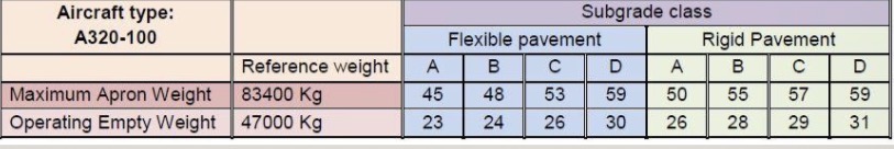
AIRCRAFT CLASSIFICATION NUMBER (ACN)
is a single unique number expressing the relative effect of an aircraft on a paved area relating to pavement type and thickness. It is a number on a continuous scale increasing from 0 with no upper limit. Each aircraft has an ACN. (FOR MANUFACTURERS OF AIRCRAFTS)
TAKE-OFF RUN AVAILABLE (TORA)
The distance between the point at which an airplane can commence the take-off run to the nearest point in the direction of take-off at which the surface is incapable of bearing the mass of the airplane under normal operating conditions.
TAKE-OFF DISTANCE AVAILABLE (TODA)
The distance from the start of TORA to the nearest obstacle in the direction of take-off projecting above the surface of the aerodrome and capable of affecting the safety of an airplane in flight. Usually, ____ is TORA plus clearway if a clearway exists
ACCELERATE-STOP DISTANCE AVAILABLE (ASDA)
The distance from the start of the take-off run to the nearest point in the direction of take-off at which the aircraft cannot roll over the surface and be brought to rest in an emergency without risk of accident.
EDA (Emergency Distance Available)
ASDA used to be called ________________. Usually
ASDA consists of TORA plus the stopway if available
LANDING DISTANCE AVAILABLE (LDA)
The distance from the point where an airplane can commence its landing to the point where the surface is incapable of bearing the mass of the aircraft under normal operating conditions. Usually this is the full length of the runway, but may include a paved stopway (if available) where the threshold is displaced
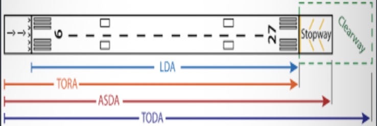

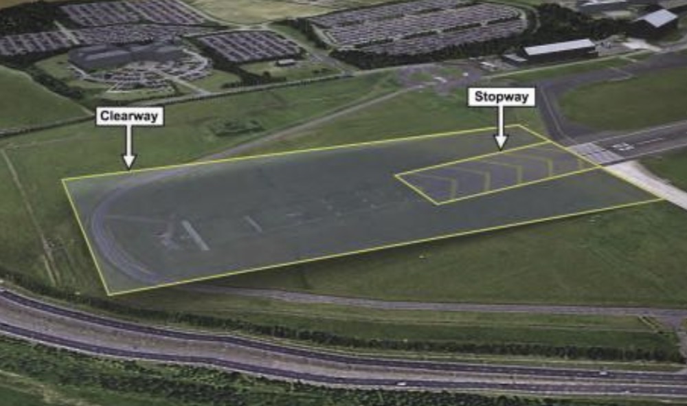
CLEARWAY
This is a defined rectangular area on the ground under the control of the appropriate authority, selected or prepared as a suitable area over which an airplane may make a portion of its initial climb to a specified height. The origin of this should be at the end of the take-off run available (TORA)
STOPWAY
is a defined rectangular area on the ground at the end of the take-off run available (TORA), prepared as a suitable area in which an aircraft can be stopped in the case of an abandoned/rejected take-off. It is to have the same width as the runway with which it is associated
BLAST PAD
Also known as overrun areas or stopways. These are often constructed just before the start of a runway where jet blast produced by large planes during the take off roll could otherwise erode the ground and eventually damage the runway.

RUNWAY
are the parts of the maneuvering area used for take-off and landing of aircraft. Except in remote areas, runways will always be prepared and usually paved (concrete and tarmac).
RUNWAY
should be straight and not have excessive slopes. In all cases, This require markings (painted on the surface) which will give the pilot indications about the use of the ______ and also assist the pilot to land the aircraft
• Paved
-Concrete
-Asphalt
• Unpaved
-Grass
-Dirt
-Macadam
TYPES OF RUNWAY (BY MATERIAL) (2)
1. Visual Runway
2. Non Precision Instrument Runway
3. Precision Instrument Runway
TYPES OF RUNWAY (BY MARKINGS) (3)
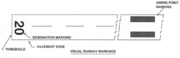
VISUAL RUNWAY
A non-instrument runway is used where take-off and landing criteria are determined visually. The criteria are usually defined by reference to ground visibility or RVR, cloud ceiling and day/night considerations. The markings of the runway will clearly indicate this fact.

VISUAL RUNWAY
VISUAL RUNWAY


NON PRECISION INSTRUMENT RUNWAY
are those having an instrument approach procedure using air navigation facilities with only horizontal guidance. They are often used at small to medium size airports. They provide horizontal position guidance to planes on instrument approach via Non-directional beacon(NDB), VHF omnidirectional range(VOR),Global Positioning System, etc.
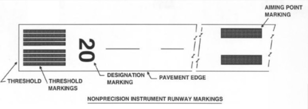
NON PRECISION INSTRUMENT RUNWAY
NON PRECISION INSTRUMENT RUNWAY


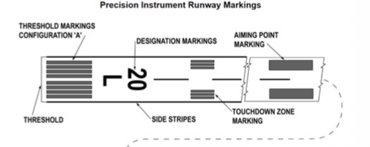
PRECISION INSTRUMENT RUNWAY
Runways equipped with an Instrument Approach Procedure that provides both lateral and vertical guidance. Found at medium and large-size airports, consists of blast pads/stopways, threshold designators, centerline, aiming points, and touchdown zone marks

LENGTH OF RUNWAY
The actual ___________ should be adequate to meet the operational requirements of the airplanes for which the runway is intended and should be not less than the longest length calculated to correct for local conditions (elevation, temperature, runway slope, humidity and surface characteristics)
WIDTH OF RUNWAY
This should not be less than that required for the airplanes using the aerodrome. During the construction of an aerodrome this can be easily achieved but with the introduction of big airplanes (e.g. the A380) previously acceptable runways may be rendered inadequate. The primary factors in deciding the _________ are wing span and outer main gear wheel span
Aerodrome Data
are useful information about a particular aerodrome (e.g.ARP, TORA, TODA, etc.)
Runways
are the parts of the maneuvering area used for take-off and landing of aircraft.
Taxiway
is defined path on a land aerodrome established for taxiing of aircraft and intended to provide a link between one part of the aerodrome and another