Geography Rivers and Coasts Paper 1.
1/84
Earn XP
Description and Tags
Name | Mastery | Learn | Test | Matching | Spaced | Call with Kai |
|---|
No analytics yet
Send a link to your students to track their progress
85 Terms
Describe how waves form.
wind blowing over the ocean creates friction with the water surface causing ripples to form.
Faster moving ripples merge with slower ones. Waves become bigger and more organised.
The longer the waves travel for, the larger and more organised they become
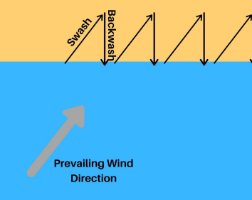
What is backwash?
movement of the wave down the beach
What is swash?
movement of the wave up the beach
Describe the features of a constructive wave.
wave crests are far apart
wave spills forward
gentle sloping wave front
strong swash and weak backwash
results in gentle beach
Describe the features of a destructive wave.
wave crests are close together
steep wave front
wave plunges downwards
strong backwash which pulls pebbles and sand out to sea
results in steep beach
What is weathering?
The breaking down of rocks by mechanical, chemical or biological processes.
What is freeze thaw action?
mechanical weathering
where rain fills up in cracks in rocks, freezes overnight and expands which pushes the crack outwards
What is mechanical weathering?
The break up of rocks by physical force.
e.g. freeze thaw and biological weathering
What is biological weathering?
weathering when living things like animals and plants burrow into a crack which eventually weakens the structure.
What is chemical weathering?
Where rainwater which contains carbon dioxide, reacts with the calcium carbonate in rocks such as limestone and chalk. This dissolves and is washed away in the solution, weakening the rock.
What are the types of mass movement?
mudflows
rockfalls
landslides
rotational slip
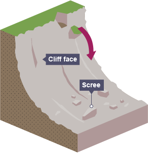
What is rockfall?
fragments of rock break away from the cliff face often due to freeze thaw weathering.
piles of rock called scree form at the bottom
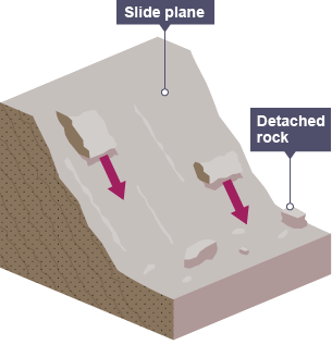
What is a landslide?
Where blocks of rock slide downhill because the bedding of the rock sloops downwards and makes it more likely that large blocks will shear out.
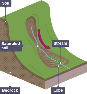
What is a mudflow?
soil or weak rock becomes saturated
occurs on slopes over 10 degrees tilt
rapid sudden movement occurs when there is not enough vegetation to hold the soil in place.
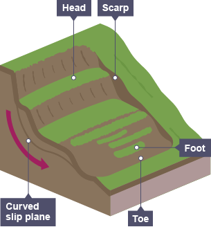
What is rotational slip?
occasional rapid movement of a mass of earth or rock sliding along a concave plane. They can occur over periods of heavy rain, when the water saturates overlaying rock, making it heavy and liable to slide.
What do processes end in?
ION
e.g.
erosion
abrasion
solution
What are the processes or erosion?
hydraulic action
abrasion
attrition
solution
What are the processes of transportation?
traction
saltation
suspension
solution
What is erosion?
The process of seawater wearing away land
What is hydraulic action?
type of errosion
The power of the waves as they smash against the cliff
trapped air is forced to make holes in the rock
this forces the rock to eventually break apart
What is corrasion?(abrasion)
type of erosion
fragments of rock, pebble and sand are picked up by waves and hurled at cliffs, acting is sandpaper
What is attrition?(it doesn’t wear the cliff down)
type of erosion
Where rocks and pebbles under the water knock against each other continuously, which chips fragments off.
What is solution?(corrasion)
type of erosion
acids in the seawater erode rock.
What is suspension?
type of transportation
particles are suspended in the flow of the water
What is solution?
type of transportation
rocks are being transported as dissolved chemicals, often from chalk
What is traction?
Type of transportation
large pebbles are rolled along the seabed by currents
What is saltation?
Type of transportation
Currents lift up pebbles which bounce along seabed.
What is deposition?
Where sediment is dropped due to less wave energy.
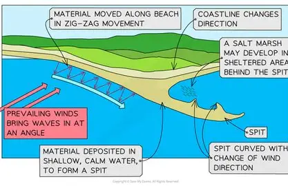
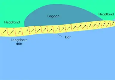
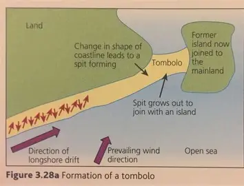
What is long shore drift (LSD)
pebble moves up the beach at an angle due to swash
backwash carries the pebble down the beach at a straight line
this happens continuously at the general direction of the prevailing wind.
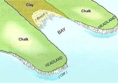
How are headlands and bays formed?
they are formed through differential erosion of hard and soft rock over time.
Also, headlands receive wave energy from all angles and therefore, the most energy because of the wave refractions
Define Landform
A feature of a landscape e.g. cliff
Define differential erosion
rocks erode at different rates
What is a discordant coastline?
Alternating bands of lots of different rock types (hard and soft) along a coastline
What is a concordant coastline?
Rocks are parallel to the wave front and therefore rates of erosion are similar.
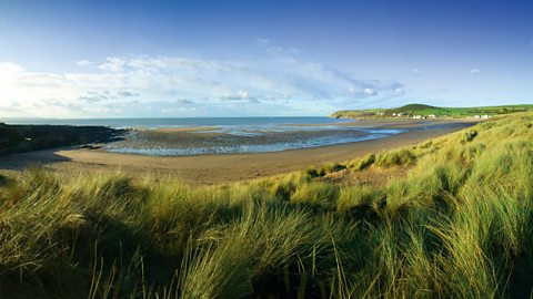
What is a beach?
A zone of deposited material that extends from the low waterline to the limit of storm waves.
What are the features of a sandy beach?
sheltered bays
strong swash
shallower beach
What are the features of a pebble beach?
high energy environment
steeper beach
Explain the formation of a sand dune.
embryo dunes form around obsticals e.g. rocks
dunes develop and are stabilised by marram grass
decomposing vegetation makes sand more fertile which increases range of plans
dune slacks can form in depressions ( ponds)
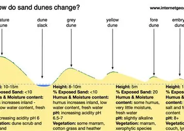
What causes formation of sand dunes?
a high tidal range
marram grass and other specialist plants
a large supply of sand
obstacles on the strand line
a strong onshore breeze
mainly constructive waves
What is a spit?
A depositional landform formed when sediment extends from the shore out to sea. It usually has curved ends because of winds and currents.
Describe the features of a spit.
Describe the features of a bar.
Describe the features of a tombolo.
What is hard engineering and it’s features?
Using concrete and large artificial structures to defend land against natural erosion processes.
expensive
long term
concrete steel or wood
visual pollution
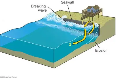
What is a sea wall?
hard engineering
concrete or rock barrier built against the sea to reduce erosion rates
Adv : highly effective, sense of security and long lasting
Dis : prevents LSD
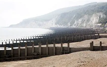
What is a Groyne?
Hard engineering
Timber or rock structures out to sea that trap sediment transported by LSD and slow wave erosion
Adv : cheap and sustainable
Dis : increased erosion by sediment and unnatural look
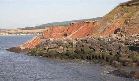
What is rock armour?
Piles of rock (usually granite) placed at foot of cliff to absorb and disperse sea energy
Adv : cheap, effective and look natural
Dis: can be shifted by waves and if done wrong could look unnatural
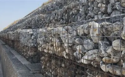
What are gabions?
Wire cages filled with belled that last 20-30 years
Adv : Cheap, effective and improve drainage
Dis : ugly and poor quality
What is soft engineering?
A sustainable and natural approach to managing coasts
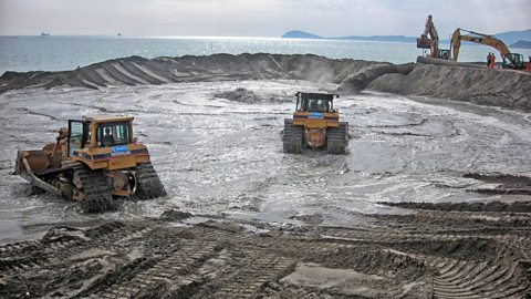
What is beach nourishment?
Soft engineering
Sand is pumped into an existing beach to build it up
Adv : blends in and can appeal to tourists
Dis : has to be constantly replaces and sand has to come from somewhere else.
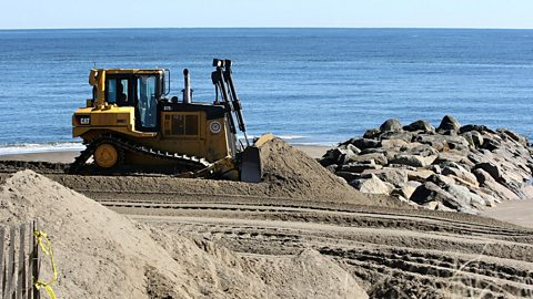
What is reprofiling?
Soft engineering
Where sediment like sand is redistributed from the lower part of the beach to the upper part
Adv : reduces energy of waves, Cheap and simple
Dis : only effective when wave energy is low and needs to be repeated continuously
What is Dune regeneration?
Soft engineering
Where marram grass is planted on sand dunes which stabilises them and helps trap sand to build them up.
Adv : cheap and looks natura
Dis : Could be damaged by storm waves and areas must be zoned off from public which could be unpopular with locals and tourists.
What is managed retreat and when is it used?
Managed retreat is where cliff erosion is allowed to take place and no protective measures are put in place.
This is used when:
land is low value
low budget
desire for a new habitat
defending coastlines are difficult
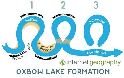
How are oxbow lakes formed?
Erosion erodes the neck of the meander
water starts to take the shortest route as the meanders neck starts to be cut through
further deposition occurs in the stagnant water as over time it will be filled with organic water which turns into an oxbow lake
What us a drainage basin?
An area of land where all the built up surface water eventually ends up at the same point like a river, lake or ocean.
What is a source?
also known as headwater
the farthest place in the river or stream from its estuary or mouth
What is drainage density?
the total number of streams in a drainage basin
the greater the number of streams in an area the higher the drainage density is
What is a tributary?
a small stream flowing into a larger stream or river or lake
What is a river channel?
The channel or groove where the river flows. v - shaped with banks
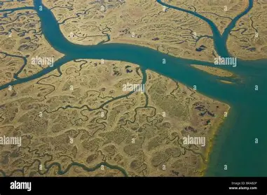
What is a delta?
NOT all rivers have these
landforms created by deposition or sediment that is carried by a river as the flow leaves it’s mouth
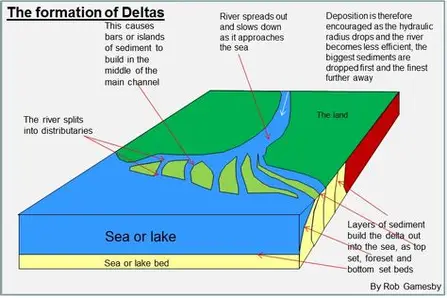
What is a river mouth?
Where the river stops flowing on land and meets the sea
What is a watershed?
This marks the invisible boundary of high ground that separates one drainage basin from another
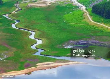
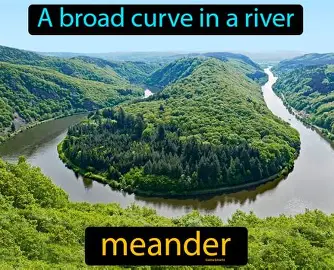
What is a meander?
Where the river bends
What is a confluence?
Where two rivers combine together to form one larger river in a single channel of water.
What is the long profile of a river?
The long profile shows the gradient of a river as it journeys from source to mouth.
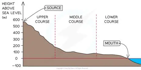
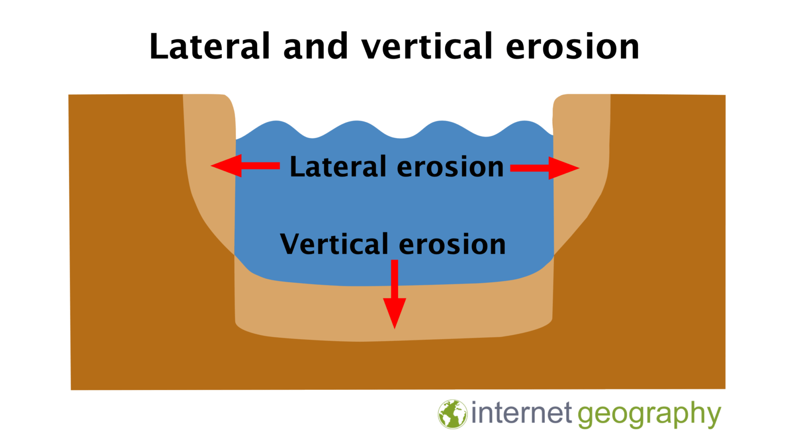
What occurs in the upper course of a river?
freeze thaw weathering to create v- shaped valleys
vertical erosion
hydraulic action
traction for transportation
waterfalls, rapids
steep, rocky, narrow, turbulent
source of river is here
interlocking spurs
What occurs in the middle course of a river?
hilly relief
greater discharge leads to less vertical erosion and more lateral erosion
erosion is mainly attrition and abrasion
transportation is mainly suspension
deposition increases and mainly happens in meanders
oxbow lakes
pools and ripples
What occurs in the lower course of a river?
flat relief
little erosion in the lower course. (some lateral)
transportation is solution and suspension
levees (deposited sediment that help to protect the river from flooding)
floodplains
estuaries
What is discharge?
The volume of water passing a given point on the river.
What is a river cross profile?
A river’s cross profile changes from steep and narrow near the source to wide and flat near the mouth as erosion and deposition shape the valley

Describe the cross profile in the upper course.
The river has a V-shaped valley with steep sides and a narrow channel. Vertical erosion is dominant as the river cuts downwards
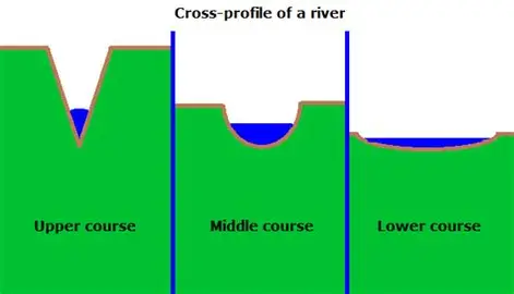
Describe the cross profile in the middle course.
The valley becomes wider with gentler slopes, and the river channel deepens and widens due to increased lateral erosion and higher discharge

Describe the cross profile in the lower course.
The river has a wide and flat floodplain where deposition dominates, resulting in lots of energy being lost at the mouth.

What are the main types of erosion that erode the riverbed and banks resulting in a changing cross profile?
Hydraulic action and abrasion
What is the difference between vertical and lateral erosion?
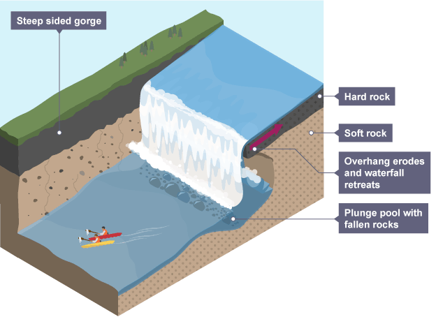
How are waterfalls formed?
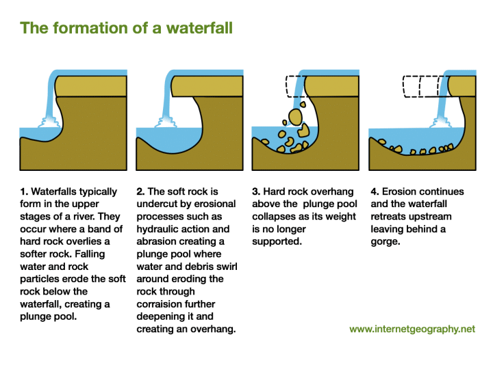
Describe and explain the features of a waterfall.
The overhang is formed by soft rock undercutting hard rock which keeps happening until the hard rock is no longer supported and collapses
The repeat of this process creates a gorge
additionally, abrasion and hydraulic action form a plunge pool
What are the physical factors that increase flood risk?
torrential storms - they can cause flash floods and flood river basins
highlands have steep slopes so encourage rapid water transfer to water channels
impermeable rocks like granite and clay mean water will be more likely to flow into a river channel which makes flooding more likely
snow formed in winter is stored in snow packs in high relief which means if it melts quickly can overwhelm river channels
What are the human factors that increase flood risk?
climate change impacting things like snow melting
deforestation - lots of water is stored by forests and woodlands. This means when it is cut down they are available to be transferred to river channels.
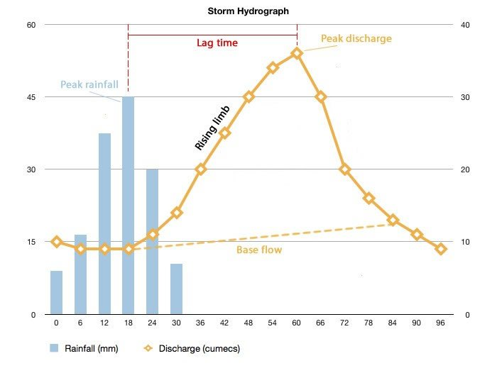
What is a storm/flood hydrograph and what is its use.
A flood hydrograph shows the relationship between rainfall and river discharge during and after a storm. It helps geographers understand why some rivers flood quickly while others respond more slowly.
What is channel enlargement.
Hard engineering
dredges the river to increase river capacity and increase discharge.
What is channel straightening?
hard engineering
speeds up water flow in a river
What is land use zoning and floodplain zoning?
land use - NEW developments constructed away from areas of high flood risk areas
floodplain - planning entire communities in a cost effective way meaning if the river floods it will only flood low value areas of land e.g. parks.
Evaluate floodplain zoning
+ high cost effectiveness
+ requires little maintenance
- limits urban expansion
- hard to apply to towns and cities that are already developed
What does afforestation do in terms of helping reduce flood risk?
reduces soil erosion
takes up water
coniferous environments would create acidic soil and low biodiversity forests
takes several years to grow