concept of hazards, plate tectonics, volcanic hazards
1/78
There's no tags or description
Looks like no tags are added yet.
Name | Mastery | Learn | Test | Matching | Spaced | Call with Kai |
|---|
No analytics yet
Send a link to your students to track their progress
79 Terms
what is a hazard?
A hazard is a threat of substantial loss/damage of life or property that can be caused by an event. These events can be caused by human actions or are mainly natural, although natural events can be a consequence of human actions
how do disasters differ from hazards
ILAN KELMAN
"disaster" is a measure of a society's vulnerability, which is created and perpetuated by human factors
A disaster is not an event and is not the fault of nature. A disaster is a process manufactured and implemented by people and their choices’
how are disasters caused by humans
Disasters are a result of human vulnerability
Political Choices: Decisions about where and what to build. For example, allowing lucrative property development in known flood-prone or seismic areas.
Social & Economic Circumstances: Poverty, discrimination, and inequality make certain groups more vulnerable. People living in cheaper, poorly constructed housing on marginal land are most at risk. Kelman notes that vulnerability due to economics (e.g., being unable to afford adequate heating/cooling or safe construction) is a critical factor.
Governance Failure: A lack of spending on crucial preventative measures, such as retrofitting buildings or investing in robust infrastructure, is a political choice that increases disaster risk.
Ideological Choices: A preference to spend money on trying to control nature (e.g., "earthquake modification") rather than on reducing people's vulnerability (e.g., constructing earthquake-proof buildings).
what are the types of hazards
geophysical, atmospheric, hydrological
what are geophysical hazards
Geophysical Hazards: driven by the Earth’s own internal energy sources e.g. plate tectonics, volcanoes, seismic activity, occur in lithosphere.
what are hydrological hazards
Hydrological Hazards: driven by water bodies and occur in hydrosphere mostly in the ocean e.g. floods, storm surges, tsunamis
what are atmospheric hazards
Atmospheric Hazards: driven by processes at work in the atmosphere e.g. tropical storms, droughts
how are different types of hazards linked
E.g. volcano eruption may change climate….
Volcanoes cause an initial cooling then long term warming affect
Tropical storm may cause flooding.
Stress there are therefore overlaps.
Stress key terminology Lithosphere etc…
what are characteristics of hazards and their effects of people
Natural hazards, and their effects on people, tend to have the following common characteristics:
their origins are clear and the effects that they produce are distinctive, such as earthquakes causing buildings to collapse
most natural hazards only allow a short warning time before the event (some hardly at all)
Exposure to the risk is involuntary, although this applies to the populations of less well developed countries. In developed areas, most of the people who occupy hazardous areas are often well aware of the risks, which they choose to minimise or even ignore
Most losses to life and damage to property occur shortly after the event although the effects of natural hazards can be felt in communities long after that time (disease, disruption to communications and economic activities)
The scale and intensity of the event requires an emergency response.
what factors affect hazard risk
Proximity to the hazard
Population density
Magnitude
The country’s level of development
Management strategies that are/aren’t in place
Scientific understanding
Public awareness of the event
Type of building construction
why do people live in areas of high risk
Hazard events are unpredictable
Lack of alternatives
Changing the level of the risk (places that were once safe could now have a higher risk i.e. deforestation increasing flood or landslide risk)
Cost/benefit
Perception
what is risk
Risk = the exposure of people to a hazardous event presenting a potential threat to themselves, their possessions and the built environment in which they live.
what is vulnerability
Vulnerability = the potential for loss & damage to a population (this varies over time and space as losses vary geographically over time and among different social groups)
how does perception of natural hazards vary
People react to the threat of hazards in different ways because of the way in which individuals receive and process information. Perception is influenced by many factors including:
socio-economic status
level of education
occupation/employment status
religion, cultural/ethnic background
Family and marital status
Past experience
values, personality and expectations.
e.g. those in a wealthier area feels more prepared to deal with a hazard, whereas those living in poorer areas have a sense of helplessness due to lack of action - economic development
what is hazard perception
Hazard perception - The way in which someone understands and interprets a hazard
This will ultimately determine the course of action taken by individuals or the response they expect from governments or organisations.
what factors affect vulnerability
1. economic factors, especially poverty and inequality
2. social factors, especially those related to population growth and demographic challenges
3. political factors, specifically the effectiveness of institutions and governance
4. environmental factors, including land degradation and access to safe water and sanitation
5. urbanisation and geographic isolation
6. global change, including technical innovation, modernisation linked to development and the effects of globalisation.
These factors are often interlinked and build on each other
how does vulnerability vary LIC/HIC and also internally? (spatially)
Poverty may go hand-in-hand with high levels of population growth and unemployment/ underemployment.
This may lead to pressure on and around cities as people migrate, resulting in overcrowding, land degradation, low standards of construction and poor sanitation – especially if the agencies of governance are underfunded or weakly regulated.
In such a context, vulnerability is likely to be expressed in terms of societal susceptibility to death, injury and homelessness through a hazard impact.
In a more affluent, well-regulated society, vulnerability is more likely to be expressed in financial terms.
E.g. Susceptibility to economic/insurance loss related to business interruption, or damage to personal property caused by a hazard impact.
In any country or region there will be significant variability in terms of vulnerability. Even the richest societies have communities whose economic or societal standing [e.g. poor people, the elderly, less mobile) makes them more vulnerable in certain hazard situations: and in the poorest societies, the vulnerability of rich elites is markedly different from that of the majority.
how can risk be calculated
'Risk' is the probability of harmful consequences or losses resulting from the impact of a hazardous process on a vulnerable population.
This relationship can be expressed as: Risk [R] = Hazard probability [H] x Elements at risk [E] x Vulnerability [V]
The hazard probability [H] could be the likelihood of an earthquake of a particular size affecting a specific location in a given period [typically 50 years].
The Elements at risk [E] are the things in the area that would be exposed to the earthquake, e.g. cities, towns, villages, or (in the case of more detailed analysis) neighbourhoods/individual buildings in a city.
Vulnerability [V] is a measure of susceptibility to loss because of the earthquake.
It could be based on a single variable [e.g. the average income level across neighbourhoods, the proportion of elderly residents in an area], or it could attempt to incorporate a weighting linked to the presence/ absence of disaster mitigation measures (e.g. building codes) and emergency planning.
Vulnerability assessments are often based on composite measures that draw on several variables.
what are the different ways to perceive a natural hazard
Fatalism (acceptance): Such hazards are natural events that are part of living in an area. Some communities would go as far as to say that they are ‘God’s will’. Action is therefore usually direct and concerned with safety. Losses are accepted as inevitable and people remain where they are. Doing nothing can seem like a defeatist attitude to take but it is an acceptance that hazards are natural events that we can do little to control and losses have to be accepted.
Adaptation: People see that they can prepare for, and therefore survive the event(s) by prediction, prevention, and/or protection, depending upon the economic and technological circumstances of the area in question. Once we accept that natural events are inevitable we can adapt our behaviour accordingly so that losses can be kept to a minimum.
Fear: The perception of the hazard is such that people feel so vulnerable to an event that they are no longer able to face living in the area and move away to regions perceived to be unaffected by the hazard.
what is risk sharing
Community preparedness/risk sharing – This involves prearranged measures that aim to reduce the loss of life and property damage through public education and awareness programmes, evacuation procedures, the provision of emergency medical, food and shelter supplies and the taking out of insurance.
what is integrated risk management
The process of considering the social, economic and political factors involved in risk analysis; determining the acceptability of damage/disruption; deciding on the actions to be taken to minimise damage/disruption.
● identification of the hazard
● analysis of the risks
● establishing priorities
● treating the risk and implementing a risk reduction plan
● developing public awareness and a communication strategy
● monitoring and reviewing the whole process.
what is mitigation
Long-term action taken to reduce or eliminate the risk to life and property from hazard events. Action is taken before, during and after disasters to break the cycle of damage and repair in hazardous areas.
what is prediction
The ability to forecast a hazardous event and then give warnings so that action can be taken to reduce their impact. Improved monitoring, information and communications technology have meant that this has become more important and accurate in recent years.
what is resilience
The sustained ability of individuals or communities to be able to utilise available resources to respond to, withstand and recover from the effects of natural hazard events. Communities that are resilient are able to minimise the effects of the event, enabling them to return to normal life as soon as possible.
how can hazard management be categorised
Prediction and warning - possible for volcanoes, less so for earthquakes - tsunamis on short notice usually. The key is monitoring - e.g. for volcanoes - monitoring the shape (swelling, bulging), emission of gases, minor tremors (seismic activity), temperatures, changes in groundwater levels/contents (minerals)
Preparation and Planning to deal with the consequences. Community preparedness has become increasingly important
Prevention and Protection in order to modify the hazard and/or mitigate the effects - prevention is hard with natural hazards due to the size, scale and power of the events
life insurance (HIC), international aid (LIC), modifications e.g. reinforced roofs, changing people’s mindsets and actions e.g. educations and evacuation schemes - reduces vulnerability
what is the hazard management cycle
A theoretical continuous 4 stage cycle of hazard management that illustrates the ongoing process by which governments, businesses and society plan for and reduce the impact of disasters, react during and immediately following an event, and take steps to recover after an event has occurred. Appropriate actions at all points in the cycle lead to greater preparedness, better warnings and reduced vulnerability or the prevention of hazard events during the next cycle. The complete cycle includes the shaping of public policies and plans that either modify the causes of the hazard events or mitigate their effects on people, property and infrastructure.
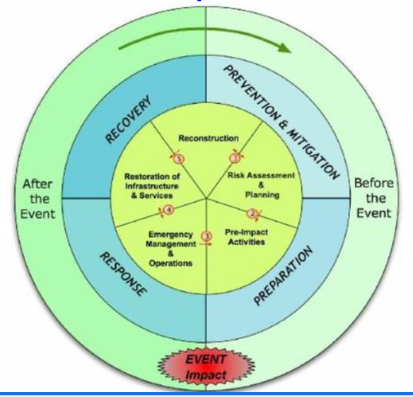
what are the pros and cons of the hazard management cycle
Pros:
It aims to reduce the losses from a hazard and speed up the recovery in quality of life.
Appropriate action can result in greater preparedness, more effective warnings and the likelihood of reduced vulnerability should the hazard strike again.
Cons:
In reality, the four phases do not occur in isolation nor necessarily in this order. More often they overlap with their length being determined by both the severity of the hazard and the area’s level of development
Other hazards may happen during the process which may alter response of an ongoing hazard and will then change the way they recover
what is Park’s model of hazard response
The Park model shows how responses progress during a disaster, which may help planners predict what resources will be needed at each stage. The model can also help planners to prepare for future hazard events. For example, the construction phase of the model shows that conditions can be improved after a disaster (e.g by designing hazard resistant buildings or installing warning systems) which will help to mitigate the impacts of future hazard events
After a disaster, the relief stage provides immediate medical care, rescue, and support, lasting from hours to days as living conditions begin to improve. This is followed by rehabilitation, where food, water, and shelter are restored to help people return to normal life over days or weeks. Finally, reconstruction involves rebuilding infrastructure, homes, and crops, and learning from the event to improve future responses; this stage can take weeks to years.
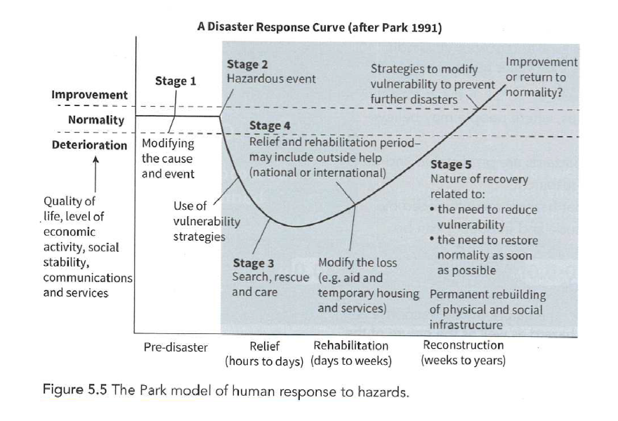
what are the pros and cons of Park’s hazard management model
Pros:
It is a useful tool to analyse the different types of response and the sequence in which they happen.
It is useful for pinpointing the different kinds of response needed at particular points in time.
Park’s model is useful in helping to plan the kinds of response need at different stages of tectonic disaster or event.
A model is only as useful as the person who is using it. Used appropriately they can help to deepen understanding of responses and the fact the some places are better able to respond than others.
Cons:
The model takes no account of inequalities in development – it assumes a level playing field between countries.
The model takes no account in the varying capacity to respond and the fact that some places will take much longer to reach different stages of relief, rehabilitation and reconstruction.
Park’s model is far to general and not specific enough about the different impacts of hazards of different magnitude and frequency, and how these can influence the ability to respond.
The model does not critically examine the fact that some countries are in need of more help from outside than others.
Park’s model does not take into account the fact that some countries or locations will never return to the same level of ‘normality’ that existed prior to the disaster.
what are primary effects of hazards
Primary effects – The effects of a hazard event that result directly from that event. For a volcanic eruption these could include lava and pyroclastic flows. In an earthquake, ground shaking and rupturing are primary effects.
what are secondary effects of hazards
Secondary effects – These are the effects that result from the primary impact of the hazard event. In volcanic eruptions these include flooding (from melting ice caps and glaciers) and lahars. In an earthquake, tsunamis and fires (from ruptured gas pipes) are secondary effects.
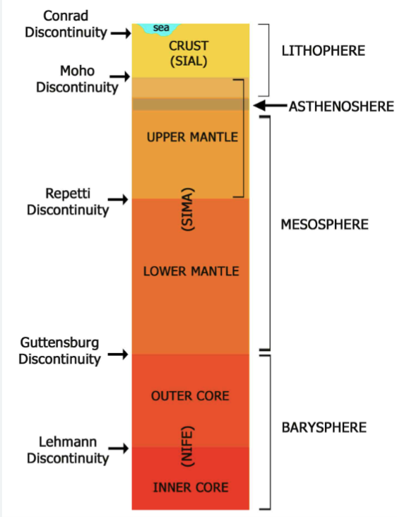
what are the layers of the earth
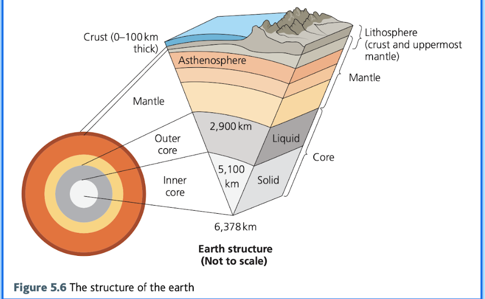
what is the core of the earth
The core is made up of dense rocks containing iron and nickel alloys and is divided into a solid inner core and a molten outer one, with a temperature of over 5000 °C.
what is the internal energy source of the earth
The heat at the core of the earth is produced mainly as the result of two processes:
primordial heat left over from the Earth’s formation and
radiogenic heat produced by the radioactive decay of isotopes
another diagram of the earth’s structure
what is the mantle of the earth
The mantle is the thickest layer and is made up of molten and semi-molten rocks containing lighter elements such as silicon and oxygen, and rich in iron and magnesium.
Mantle is almost entirely solid but the upper section is where rocks flow and deform plastically, as rocks are still solid but on the verge of melting so behave like a viscous liquid (asthenosphere)
what is the lithosphere (and asthenosphere)
The lithosphere consists of the crust and the rigid upper section of the mantle and is approximately 80 – 90 km thick.
This is the section of the Earth that is divided into seven very large plates and a number of smaller ones.
Plates are divided into two categories, oceanic and continental, depending on the type of material from which they are made.
The asthenosphere lies beneath this layer and is semi- molten on which the plates float and move.
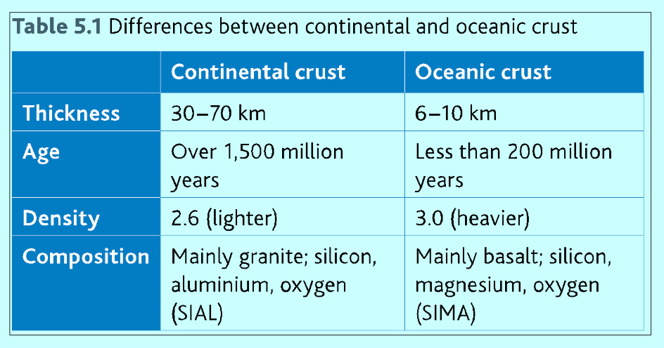
how do continental and oceanic crust differ
Continental crust is thicker, older and less dense. SIAL (granite, silicone, aluminium & oxygen)
Oceanic crust is thinner, younger and more dense. SIMA (Basalt, Silicon, Magnesium, Oxygen)
why is plate tectonics still a theory
Plate tectonics remains a theory because the internal workings of the Earth cannot be directly observed by scientists.
The deepest that humans have drilled into the Earth's crust is 12,262m [at the Kola super deep borehole in Russia, 1989).
Which is a mere 0.1 % of the distance to the centre of the Earth.
However, scientists have used seismic (shock) waves to probe the interior of the Earth and have identified a number of layers with different densities, physical properties and chemical composition
what is plate tectonic theory
The theory of plate tectonics describes the processes that cause earthquakes, volcanic eruptions, and tsunamis, and is a key development in Geography over the last 100 years. It explains that the Earth's rigid outer shell, the lithosphere (crust and upper mantle), is broken into large pieces, or tectonic plates, that move. The theory evolved slowly, with foundations worked out in the 1960s (Alfred Wegener), building upon the earlier, less complete idea of Continental Drift. The theory is still subject to new research and widespread debate because the internal workings of Earth cannot be directly observed.
what is the role of the asthenosphere
The asthenosphere plays a key role in plate tectonics because it is a low-viscosity, plastic, partially molten layer on which the rigid lithospheric plates can slide. It allows the solid lithosphere to move over the mantle below. This layer, located beneath the lithosphere, is also known as the Low Velocity Zone (LVZ), where the speed of seismic P- and S-waves slows down at a depth of about 100-200 km. Its properties (low seismic velocity and high electrical conductivity) are explained by the presence of some water and a small amount of molten rock (perhaps 1-4%).
how has plate tectonic theory developed over time
As soon as maps of the Atlantic Ocean were produced, people began to notice that the continents either side seemed to fit together remarkably well – the bulge of South America fitting into the indent below West Africa
In 1912, a German, Alfred Wegener, published his theory that a single continent existed about 300 million years ago. He named this super-continent Pangaea and maintained that it had later split into the two continents of Laurasia in the north and Gondwanaland in the south.
Today’s continents were formed from further splitting of these two masses.
Wegener published this theory of continental drift and claimed that it was supported by several pieces of evidence that these areas were once joined.
Alfred Wegener’s ‘Continental Drift theory' inspired other researchers to think seriously about the idea of the Earth's continents moving around, such that scientists began searching for a plausible mechanism to drive this movement.
A number of ideas and field/laboratory investigations contributed pieces to the jigsaw that became Plate Tectonics Theory.
New ideas are still emerging, for example, on the role of 'hotspots’ and the complexity of fold mountain belts.
how many tectonic plates are there
The Earth has 7 major plates [more than 20 million km2 ] 7 minor plates and lots of micro plates.
Some areas, such as the Caribbean, Eastern Türkiye, Iran and Indonesia, are composed of an intricate pattern of major, minor and micro plates with multiple tectonic junctions.
They constitute some of the world's most complex and active tectonic areas.
what is geological evidence for plate tectonic theory
Fit of South America and West Africa |
Glacial deposits found in South America, Antarctica and India. |
Striations on rocks in Brazil and West Africa which point similar direction |
Rocks in Scotland which agree with those in eastern Canada |
what is biological evidence for plate tectonic theory
Fossil brachiopods found in Indian limestone are comparable with similar ones in Australia |
Fossil remains of reptiles found in South America and Southern Africa unlikely developed in both areas or that is could have migrated |
Fossilised remains of a plant which existed when coal was being formed have been located in India and Antarctica |
what is paleomagnetism and sea floor spreading and how does it support plate tectonic theory
The mid-Atlantic ridge was discovered and studied along with a similar feature in the Pacific Ocean. Examination of the ocean crust either side of the mid-Atlantic ridge suggested that sea-floor spreading was occurring.
Evidence for this is alternating polarity of the rocks that form the oceanic crust.
Iron particles in lava erupted on the ocean floor are aligned with the Earth’s magnetic field.
Palaeomagnetism is when lava solidifies the iron particles provide a record of the Earths polarity at the time of the eruption. [The Earth’s polarity reverses at regular intervals about every 400,000 years]
As a result there are magnetic stripes with rocks aligned alternately towards the north and south poles.
The striped pattern is mirrored exactly on either side of the mid-ocean ridge which suggests that oceanic crust is slowly spreading away from the boundary.
Plus the oceanic crust gets older with distance from the mid-oceanic ridge.
Sea-floor spreading implies that the earth must be getting bigger. As this is not the case, then plates must be being destroyed somewhere to accommodate the increase in their size at mid-oceanic ridges.
![<ul><li><p><span style="background-color: transparent;"><span>The mid-Atlantic ridge was discovered and studied along with a similar feature in the Pacific Ocean. Examination of the ocean crust either side of the mid-Atlantic ridge suggested that </span><strong><span>sea-floor spreading </span></strong><span>was occurring.</span></span></p></li><li><p><span style="background-color: transparent;"><span>Evidence for this is alternating polarity of the rocks that form the oceanic crust. </span></span></p></li><li><p><span style="background-color: transparent;"><span>Iron particles in lava erupted on the ocean floor are aligned with the Earth’s magnetic field. </span></span></p></li><li><p><span style="background-color: transparent;"><strong><span>Palaeomagnetism</span></strong><span> is when lava solidifies the iron particles provide a record of the Earths polarity at the time of the eruption. [The Earth’s polarity reverses at regular intervals about every 400,000 years]</span></span></p></li><li><p><span style="background-color: transparent;"><span>As a result there are </span><strong><span>magnetic stripes </span></strong><span>with rocks aligned alternately towards the north and south poles. </span></span></p></li><li><p><span style="background-color: transparent;"><span>The striped pattern is mirrored exactly on either side of the mid-ocean ridge which suggests that oceanic crust is slowly spreading away from the boundary. </span></span></p></li><li><p><span style="background-color: transparent;"><span>Plus the oceanic crust gets older with distance from the mid-oceanic ridge. </span></span></p></li><li><p><span style="background-color: transparent;"><span>Sea-floor spreading implies that the earth must be getting bigger. As this is not the case, then plates must be being destroyed somewhere to accommodate the increase in their size at mid-oceanic ridges. </span></span></p></li></ul><p></p>](https://knowt-user-attachments.s3.amazonaws.com/29e405d9-cbce-4253-bdb6-a80e07c7d49e.png)
how do tectonic plates move
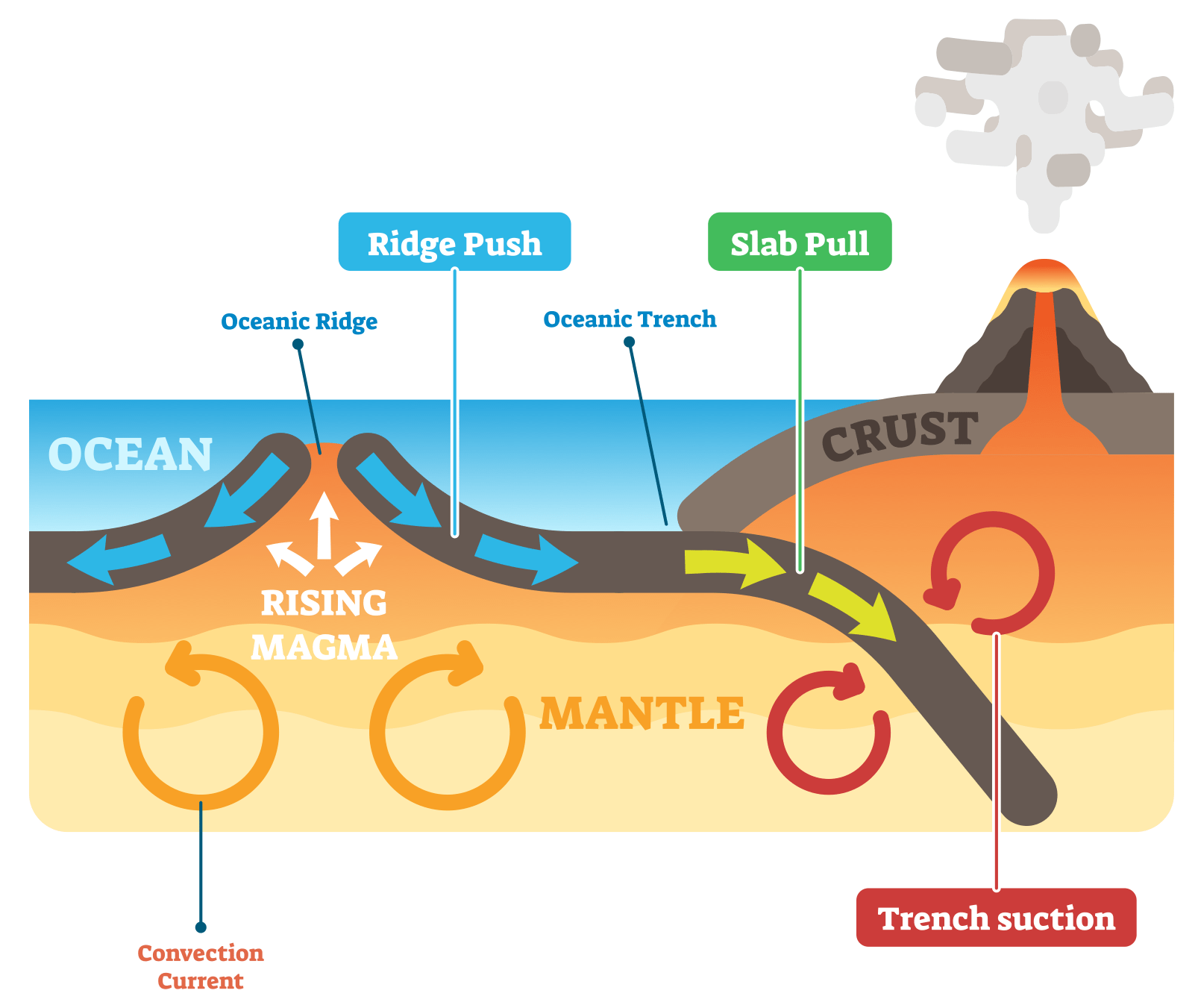
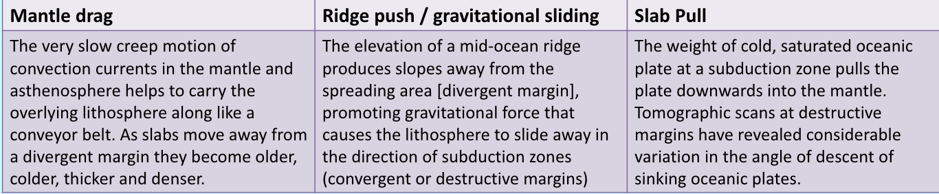
It was previously thought that convection currents within the mantle drove plate movement. Uneven distribution of temperatures towards the base of the mantle caused convection cells which dragged the lithospheric plates with them when the moving mantle reached the surface. This theory has been partly discounted because most of the mantle is not fluid. Scientists now believe that convection currents play only a supporting role in the current dynamic models (ridge push and slab pull) in which plates move as part of a gravity-driven system.
Mantle convection certainly exists, but the current consensus is that convection alone is a weak force and that plate movement depends on other push and pull mechanisms that operate on plates, particularly oceanic plates.
The key to understanding plate movement lies with the Earth's asthenosphere - the weak layer, on which the solid, rigid lithosphere [crust and upper mantle] can move over the mantle. This was confirmed when scientists discovered how seismic waves travelled through the lithosphere and upper mantle.
The asthenosphere plays a key role in plate tectonics because the rocks within it are ductile [they do not fracture]. They flow and deform plastically, providing a partially-molten, lubricated layer on which lithospheric plates can slide.
what is slab pull
At a destructive (subduction) boundary, older, colder oceanic plates are denser than the underlying mantle. As the subducting plate is much colder and heavier than the hotter mantle, it sinks into the mantle due to the downward gravitational force acting on it and pulls the whole oceanic plate down into the mantle. The force that the sinking edge exerts on the rest of the plate is called slab pull.
The concept of slab pull suggests that the subducting slab pulls on the rest of the tectonic plate, stretching and thinning the plate at the divergent margin, thus reducing pressure on the underlying asthenosphere. This allows it partially to melt and for magma to well up (as in sea floor spreading), forcing the oceanic crust to form the ridge and rift features of a mid - oceanic ridge. As the lower part of the slab is pulled downwards, it may detach and set up deformation in the upper mantle, inducing a weak convection current that sucks overlying plates together [slab suction).

what is ridge push/gravitational sliding
At constructive boundaries where plates are moving away from each other, less dense, hot magma wells up and produces an ocean ridge (2-3km above the ocean floor). This rock heats the surrounding rocks, which expand and rise above the surface of the surrounding crust, forming a slope.
As this newly formed rock gets older, it cools becoming denser. Gravity acting on this older, denser lithosphere causes it to slide away from the ridge down the asthenosphere. This puts pressure on the tectonic plates, causing them to move apart. Ridge push is also known as gravitational sliding
The occurrence of shallow earthquakes, resulting from the repeated tearing apart of the newly formed crust, indicates that there is also some frictional resistance to this force.
what are the ways for plate to move
what are the types of plate boundaries
constructive (divergent) plate margin
destructive (convergent) plate margin
conservative (passive) plate margin
how do plate movements connect together
Gravitational Sliding: The lithosphere thickens with distance and time from the mid-ocean ridge. This is because it cools with distance and the boundary between the solid lithosphere and plastic asthenosphere becomes deeper. The result of this thickening with distance from the ridge is that the lithosphere/ asthenosphere boundary slopes away from the ridge. Gravity acting on the weight of the lithosphere near the ridge ’pushes’ the older part of the plate in front (ridge push). Following subduction the lithosphere sinks into the mantle under its own weight, helping to ‘pull’ the rest of the plate with it (slab pull).
Convection Currents: hot rises, cool sinks, cycle like a pan of hot water.
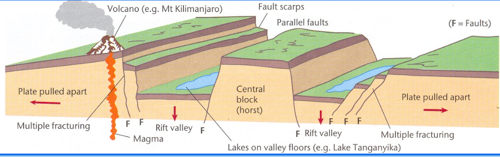
what happens at a continental constructive boundary
RIFT VALLEY IS FORMED
e.g. East African Rift Valley - African and Somalian plates
1 plate splitting into 2 plates – to form an ocean
Plate cracks / drops / forms a valley / valleys
Block between valleys is called horst
Rising magma caused the whole region to be uplifted. This created weaknesses in the crust, through which low viscosity basalts emerged and flooded the area. As with the oceanic ridge, there was a partial collapse of the crust and the development of a deep, steep-sided rift valley. The two sides of the rift valley are slowly moving apart, and it is believed that it will eventually flood with sea water and become a new ocean separating Africa into two parts.
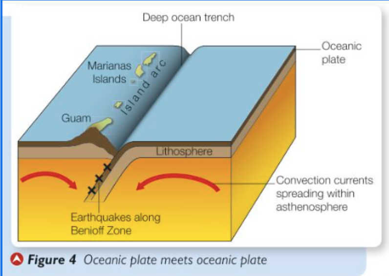
what happens at an oceanic/oceanic destructive plate boundary
Where oceanic crust meets oceanic crust, the more dense oceanic crust subducts beneath the less dense oceanic crust and a line of volcanic islands known as an island arc can appear. On the western side of the Pacific Ocean, where the Pacific plate is being subducted beneath the smaller Philippines plate, a line of volcanic islands, including Guam and the Marianas, has been formed from magma upwelling from the Benioff zone.
Two plates are pushed together and the denser or faster crust gets subducted beneath the lighter crust. This makes a deep ocean trench.
The plate sticks and locks as it tries to slide under the plate.
Heat from friction and the mantle starts to melt the subducted plate. Then it rises up from the Benihoff zone as a submarine volcano which could grow to form island arcs.
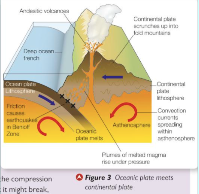
what happens at an oceanic/continental destructive plate boundary
The denser oceanic plate is forced under the lighter continental plate in the process of subduction. The downward displacement (downwarping) of the oceanic plate forms a deep-sea trench that runs parallel to the plate boundary. The Challenger Deep, in the Marianas Trench, is the deepest part of the ocean at just over 10,900 metres. During the subduction process, sediments that have accumulated on the edge of the continental plate are deformed by folding and faulting and then uplifted to form young fold mountains (such as the Andes). Fold mountains are parallel chains of high volcanic mountains with an inter-montane plateau between them.
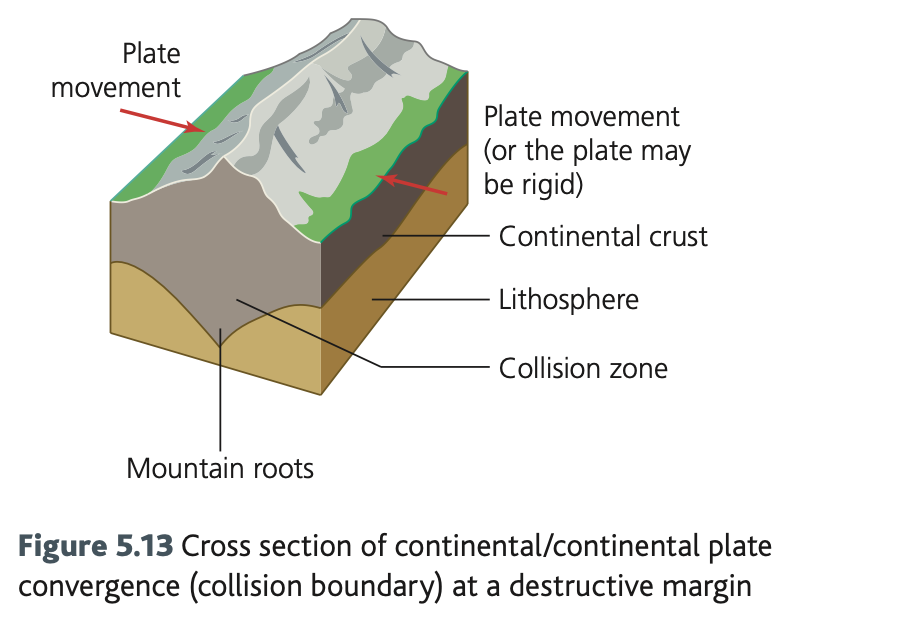
what happens at a continental/continental destructive plate boundary
If two low density continental plates converge, subduction does not occur. Sediments between them are forced up into young fold mountains. This is what is happening where the Indo-Australian plate is being forced northwards into the Eurasian plate, forming the Himalayas. There is no volcanic activity, but the movement can trigger shallow-focus earthquakes.
what happens at a conservative plate boundary
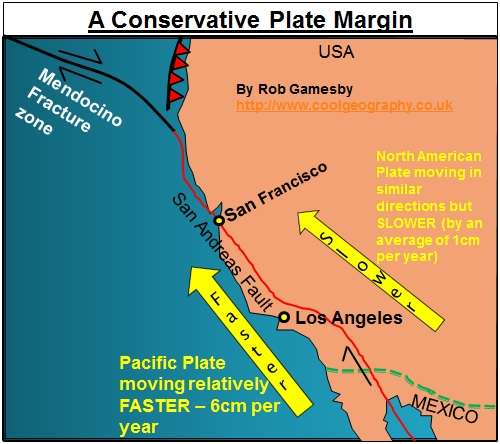
Where two plates slide past one another, parallel to the plate margins, there is no subduction and therefore no volcanic activity. The movement of the plates does create stresses between the plate margins, particularly when they get stuck. Sudden movements of the plates trigger shallow focus earthquakes. The most well- known example of a conservative plate margin is the San Andreas Fault complex in California, where the Pacific and North American plates move in the same direction but at different speeds. Stresses set up by this movement cause transform faults to develop running at right angles to the main fault.
Can be same direction, different direction, different speeds.
Along these margins crust is not being destroyed by subduction. There is no melting of rock and, therefore, no volcanic activity or formation of new crust. Despite the absence of volcanic activity, these margins are extremely active and are associated with powerful earthquakes. Friction between the two moving plates leads to stresses building up whenever any 'sticking' occurs. These stresses may eventually be released suddenly as powerful shallow-focus earthquakes, such as in Los Angeles (1994) and San Francisco (1906 and 1989).
what are hotspots/magma plumes
In the 1970s, a theory was developed to explain the presence of volcanic activity away from plate boundaries. It proposed that localised heating at the core/mantle boundary caused a plume of magma to rise through the mantle and ‘eat’ into the plate above the so-called ‘hot spot’. Where the lava broke through to the surface, active volcanoes formed above the hot spot. While the hot spots are thought to be fairly stationary, the tectonic plates continue to move. As a plate continues to move away from the hot spot, it takes with it the volcanoes that have formed. These volcanoes cool and subside, and over millions of years a chain of islands, atolls and seamounts (known as hotspot tracks) can form. The volcanoes get progressively older (and become extinct) the further they move away from the hot spot. The youngest and most active volcanoes are found directly over the plume.
In certain places, a concentration of radioactive elements below the crust causes a hot spot to develop.
A plume of magma rises to eat into the plate above.
When this lava breaks through to the surface, active volcanoes form above the spot.
The basaltic lava flows slowly and forms huge but (relative to the area covered) flattish volcanoes, sometimes referred to as ‘shield’ volcanoes
The Hawaiian Islands in the Pacific Ocean is one example.
The hot spot is stationary, so as the Pacific plate moves over it, a line of volcanoes is created.
The one above the hot spot is active and the remainder form a chain of islands with extinct volcanoes.
where does volcanic activity happen
Subduction volcanoes are located on converging, destructive plate margins.
Rift volcanoes occur where tectonic plates diverge and magma spreads
Hotspot volcanoes occur where plumes rise from the Earth's interior to penetrate the surface of the lithosphere.
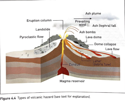
what are primary effects of volcanic events
Primary effects are brought about by material ejected from the volcano and described below:
Tephra
Pyroclastic flows (nuées ardentes)
Lava flow
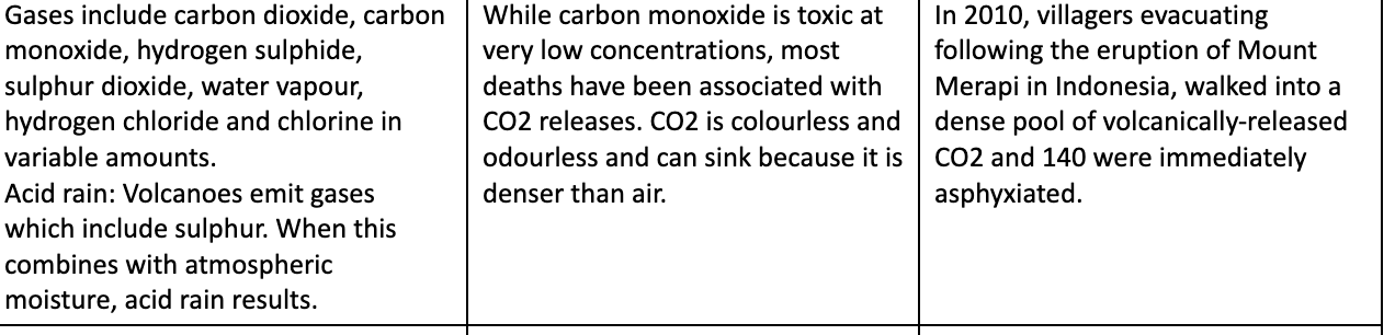
Volcanic gases
what are secondary effects of volcanic events
Secondary effects:
Lahars (mud flow)
Flooding
Volcanic landslides
Tsunamis
Acid rain
Climate change
what are forms of volcanic hazards
Forms of volcanic hazard: nuées ardentes, lava flows, mudflows, pyroclastic and ash fallout, gases/acid rain, tephra
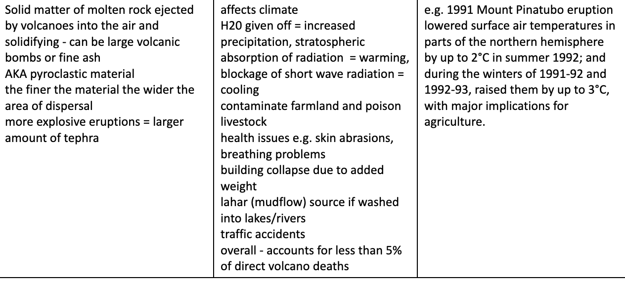
tephra - description, effect, example
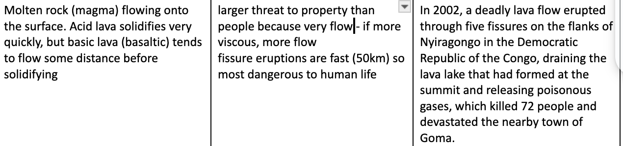
lava flows - description, effect, example
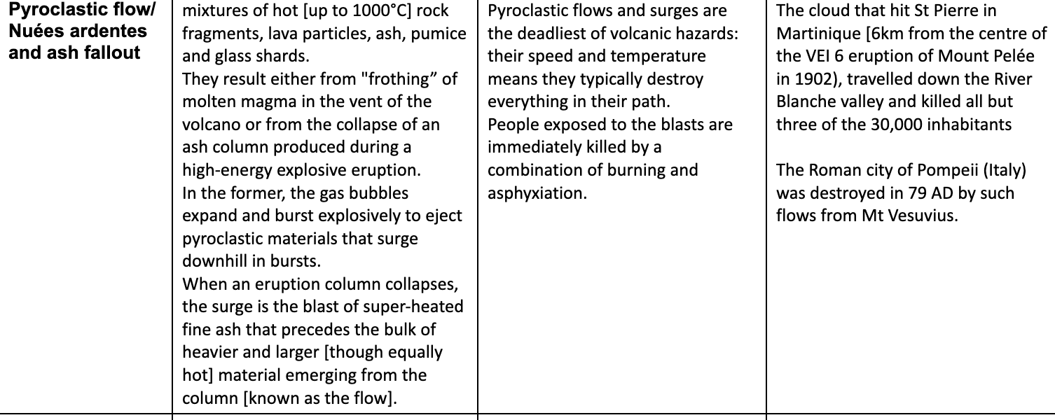
Pyroclastic flow/ Nuées ardentes and ash fallout - description, effect, example
gases/acid rain - description, effect, example
what is a volcano
A volcano is an opening or vent in the earth’s surface through which molten material erupts and solidifies as lava.
All volcanoes are formed from molten material (magma), which is a complex mixture of silicates containing dissolved gases and often an array of crystallised minerals in suspension.
what are categories of volcanoes
Active volcano – likely to erupt e.g. Popocatepetl
Dormant (sleeping – French / Spanish Dormir…) volcano – a volcano which has not erupted for many years. E.g. Mount Kilimanjaro
Extinct volcano – a volcano which has not erupted for many thousands or millions of years e.g. Edinburgh.
what are the parts of a volcano
Parasitic cone / secondary cone = this is the secondary cone forming on the side of the volcano
Crater = This is the depression at the top of the vent
Main vent = This is the pipe up the middle of the volcano
Magma chamber = This is the source of the molten rock
what is the global distribution of volcanoes
Distribution:
The Pacific ring of fire is 40,000km which shows high density of volcanoes
Volcanoes are common at constructive and destructive margins but absent from transform faults.
Some volcanoes happen in the centre of plates like Hawaiian hot spot and East African Rift Valley.
The type and magnitude vary according to location which has an impact on the type of magma.
how does silica content affect lava
The nature of lava and hence the power of an eruption is largely determined by its silica content and presence of other gases.
The greater the silica content the greater the lava’s viscosity, creating slower flowing lava with more explosive gases.
High silica content lavas are created along subduction zones as crust is melted.
how is the magnitude of volcanic events measured
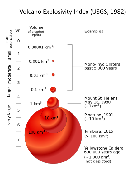
The main method of measurement of magnitude has been the volcanic explosivity index (VEI), a logarithmic scale running from 0 to 8.
Quiet lava-producing eruptions (e.g. Hawaiian eruptions) score 0–1 on the index whereas the eruption of Mt St Helens (USA) (1980) scored 5 and Pinatubo (Philippines) (1991) was rated at 6 on the scale.
Colossal eruptions on the scale of 7–8 occur very infrequently.
Volcanologists estimate that the last eruption at 7 on the scale was Tambora (Indonesia) in 1815 and to find the last eruption which was graded 8, we have to go back around 73,000 years to Toba (Indonesia).
When the supervolcano under Yellowstone National Park erupts the VEI might exceed 8 and change global climates for years afterwards
Critics of the VEI point out that it does not take into account gas emissions or the atmospheric/ climatic impact of eruptions.
how can frequency of volcanic events be determined
To determine the frequency of eruption of any volcano, its previous history of activity can be interpreted by volcanologists using the deposits associated with the volcano itself and those within the wider region it can effect.
The uncomfortable reality is that volcanoes such as Mount St Helens and Chances Peak, Montserrat, have proved to be dormant rather than extinct.
Even for those volcanoes known to be dormant, relying on average cycles of activity can only alert volcanologists of the necessity for heightened observation.
how can volcanic events be predicted and monitored
A study of the previous eruption history of any volcano is important, along with an understanding of the type of activity produced.
There are several ways in which volcanologists are seeking to give a fairly accurate timing for an eruption.
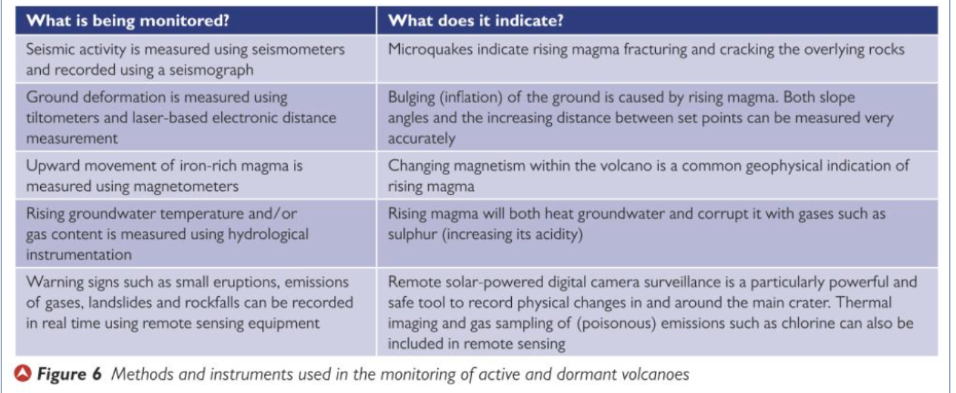
These include: monitoring of land swelling, changes in groundwater levels and the chemical composition of groundwater and gas emissions.
It is also possible to monitor seismic activity looking for the shock waves that result from magma moving towards the surface, expanding cracks and breaking through other areas of rock.
Unlike earthquakes there is little or no warning, volcanic eruptions tend to follow weeks of seismic activity and other warning signs.
As long as active and dormant volcanoes are monitored, using seismometers and seismographs warnings of imminent eruptions can be issued to governments and civil authorities.
Prediction can be successful particularly when aided by evidence form previous eruptions such as lahars and pyroclastic deposits in river valleys.
Hazard maps can also be produced to identify those at risk and to be prioritized for evacuation.
how can volcanic events by managed through prediction
Early prediction means that people can be evacuated from the danger zone and lives can be saved. There are risks associated with living in close proximity to a potentially devastating volcano, and hazard risk mapping is important in the drive to cut death tolls from volcanic hazards.
Hazard risk maps identify areas exposed to different volcanic hazards.
Many earthquakes are now monitored continually, either by local observatories or by satellite. Signs that a volcano may erupt include:
an increase in the release of various gases, particularly sulphur dioxide and carbon dioxide
a rise in the level of lava lakes in volcanic craters
the bulging upwards of surrounding land due to pressure from below
an increasing number of relatively small earthquakes caused by the rising magma.
A study of the previous eruption history of any volcano is important, along with an understanding of the type of activity produced. Ash, lahars and pyroclastic flows leave characteristic deposits around volcanoes. We can assume that if this type of hazard appeared once, it will be repeated. It is also possible to identify areas at greatest risk and the frequency of eruptions from these layers of deposits.
how can volcanic events be managed through mitigation
Risk assessment prior to warn public of the threat and determine the most vulnerable
During an eruption, some physical actions can be undertaken to reduce the impacts:
Once viscous lava has started to flow, it may be possible to divert it from the built environment. On Mt Etna in Sicily, digging trenches, dropping blocks into the lava stream and using explosives have been successful in slowing down the flow and, in some cases, diverting it.
In 1973, the inhabitants of Haeimaey (Iceland) were able to pour seawater on the front of a lava flow to solidify it before it cut off their vital fishing port from the open sea.
In parts of the Hawaiian Islands, barriers have been built across valleys to protect settlements from lava flows and lahars.
Evacuation: evacuate vulnerable areas when risk becomes intolerable. This comes with its own problems. If an evacuation is carried out needlessly, future evacuations are more difficult to manage as perception of risk is lowered.
can volcanic eruptions be prevented?
no
how can people be protected against volcanic events
Engineering - in terms of pyroclastic fall and flow hazards, protection mainly depends on building strength and design.
Ash accumulation [particularly if it is wet] can cause building collapse at distances of up to 50km from the source. Reinforced concrete frame structures provide the greatest protection and pitched roofs help reduce ash build-up.
Nevertheless, only buildings of the sturdiest construction will resist pyroclastic flows.
In poorer communities, protection measures may centre on a few resistant buildings that serve as refuges for residents.
At Mount Sakurajima in Japan, concrete tunnels have been excavated as refuges from volcanic bombs.
how can volcanic events be adapted to
Perhaps the best response is to move away from the area surrounding the volcano. In the case of Montserrat, this move proved to be permanent for many people and they had to change their way of life, often in a new country.
In the east of the Democratic Republic of the Congo, farmers returned to their fields after the eruption of Nyiragongo (2002) and within a short time they were able to change the crops they cultivated, moving from maize to cash crops such as cabbage and bananas. In some cases, their income doubled from before the eruption.