Lithosphere Unit 2 Test
1/24
There's no tags or description
Looks like no tags are added yet.
Name | Mastery | Learn | Test | Matching | Spaced | Call with Kai |
|---|
No analytics yet
Send a link to your students to track their progress
25 Terms
The Atlantic Ocean is getting larger because of ___
Which layer of the Earth is divided into tectonic plates?
Which geographic features form as a result of continental-continental convergent plates?
In the Four Corners area of the southwestern United States, there are large rocky outcroppings of basalt. These were formed by ancient lava flows. Using this information, what class of rock is this?
What is the BEST example of physical weathering in your notes?
What would be most effective in minimizing the potential damage caused by an earthquake?
Why does oceanic crust generally tend to subduct under continental crust when plates collide?
What type of boundary made Mt. St. Helens?
According to geologists, the Earth is approximately how old?
After fossils are formed, which process is MOST likely to destroy them?
Which type of plate boundary is MOST responsible for the formation of the Himalayan Range?
Identify a landform made at a convergent boundary.
How are sedimentary rocks made?
A volcano releases a towering plume of toxic ash and gases into the atmosphere. Which of these would best allow scientists to warn officials of a need for evacuation of people living far away from the volcano?
Explain why the outer core of the Earth is liquid and the inner core is solid.
The surface of Earth is composed of large tectonic plates that are constantly shifting as they float on top of molten rock. Which process must occur in the mantle to make the plates move?
A scientist was examining a large boulder that was covered with lichens (a combination of fungi and algae). He chipped a piece of the rock and placed it under a microscope. He observed that the surface of the rock was breaking down underneath the lichen. Which was the scientist MOST likely observing?
Water is a very important part of the physical weathering of rock. Which of these properties of water is MOST important in causing some of the physical weathering of rock?
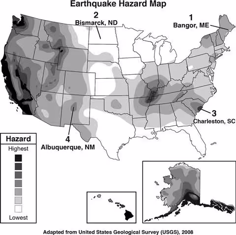
The United States Geological Survey (USGS) maintains a set of earthquake hazard maps that cities and towns use for developing building codes. Based on the map, which city or town is located in an area of greatest earthquake hazard?
A geologic cross section of the Himalayan Mountain Range is shown below. This mountain range is the result of which type of boundary interaction?
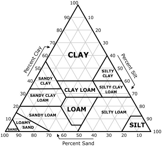
This is a diagram of a soil texture triangle. Farmers can use this chart to identify the type of soil found on their land and determine the likelihood of erosion and other important factors. What type of soil does a farmer have if the soil contains 40% sand, 40% silt, and 20% clay?
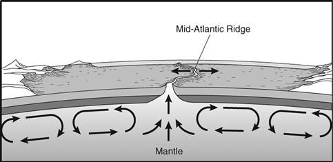
The diagram below represents a process that occurs within Earth’s mantle. What process is represented by this diagram?
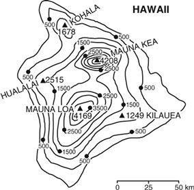
The diagram below shows a topographic map of the big island of Hawaii. Which volcanic mountain is the highest?
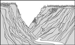
A student observes the many V-shaped valleys that are part of Grand Canyon National Park. What destructive force has done the MOST work on this landscape?
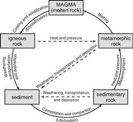
Use the diagram of the rock cycle to answer the question that follows. What has to occur to change igneous rock into sediment?