PPL
1/86
There's no tags or description
Looks like no tags are added yet.
Name | Mastery | Learn | Test | Matching | Spaced |
|---|
No study sessions yet.
87 Terms
air mass
a huge body of air with similar temperature and moisture content
front
boundary between 2 air masses with different temperatures
squall line
created by pressure wave in advance of a fast-moving cold front
squall lines can create thunderstorms up to
200 miles before front (often more severe than along front)
standard atm
15°C, 29.92inHg
is there turbulence in stable air?
no
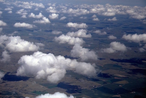
what clouds form in stable air?
stratus clouds with smooth tops (air cannot rise)

what precipitation is in stable air?
steady
what is the visibility in stable air?
reduced (condensation/fog)
is there turbulence in unstable air?
yes
what clouds form in unstable air?
cumuliform clouds (air can rise)
what precipitation is in unstable air?
showery
what is the visibility in unstable air?
good (except in showers)
lapse rate
the rate of decrease of air temperature with altitude (determines atmosphere stability)
standard lapse rate
2°C per 1000 ft
air mass is stable if lapse rate is ____ than standard
less
air mass is unstable if lapse rate is ____ than standard
greater
thunderstorms are created when
air is forced to rise in unstable air and has water vapor
radiation fog
shallow fog with clear skies above
radiation fog develops when
air near ground cools (wind above inversion can be stronger)
advection fog typically forms
in winter on coast when warm air flows over cooler land (requires wind)
upslope fog develops
as stable air is forced up a slope and expands and cools (requires wind)
precipitation-induced fog occurs
when warm rain falls through cooler air
steam fog forms
as cold air flows over warmer water (requires light wind)
thunderstorm clouds
cumulonimbus
to form, thunderstorms require
a lifting force, unstable air, high humidity
cumulus stage of thunderstorm
(1) vertical cloud build-up with strong updrafts
mature stage of thunderstorm
(2) downdrafts (precipitation, gusts, temperature drops, pressure increases) and updrafts (vertical wind shears) *most dangerous
dissipating stage of thunderstorm
(3) downdrafts (dangerous: hail, turbulence)
air mass thunderstorms
20-90 min; isolated storms caused by surface heating
frontal thunderstorms
long; associated with fronts, converging winds, and troughs aloft; may generate squall lines
squall line thunderstorms
long; most hazardous (tornadoes, hail, heavy rain, strong wind, etc.)s
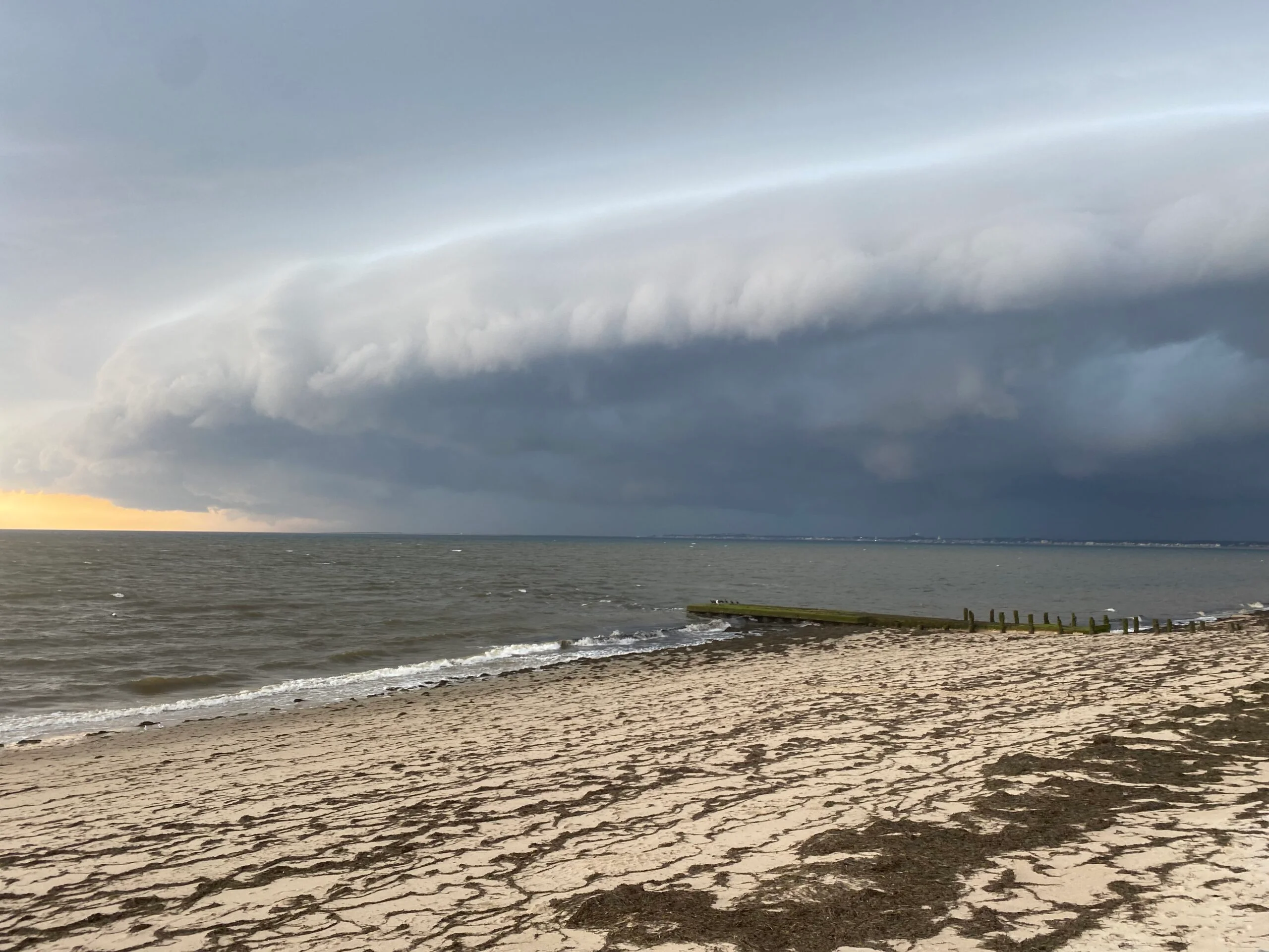
shelf cloud
rain-cooled air moves ahead of storm (identify & avoid storms)
wind shear
a sudden change in wind direction or speed over a short distance/period
microburst
small-scale intense downdraft
microbursts are found
anywhere there is convective activity
microbursts spread horizontal winds as far as
2.5 miles in diameter at 45 kts
sign of a microburst on takeoff
shift from increasing headwind to tailwinds
sign of a microburst in air
updraft (increase power & go around)
sign of microburst on landing
shift from increasing headwind to tailwind; updraft followed by decrease in airspeed and rapid descent (increase power & go around)
hot air/convective turbulence
surface is heated = air rises; base of clouds is top of turbulence
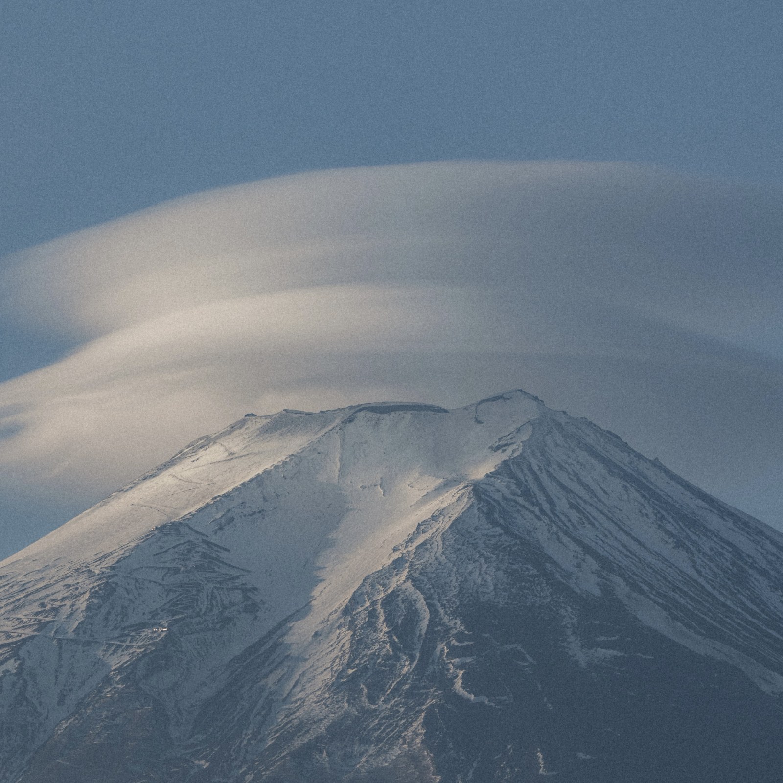
mountain wave
air going over ridge creates lenticular clouds on downdraft side and turbulence below them
frost reduces
lift
frost increases
stall speed
frost can prevent
aircraft from becoming airborne at takeoff speed
ice pellets on the ground means
freezing rain at higher altitudes
icing reduces
lifti
icing increases
stall speed & drag
icing changes
the shape of the wing
high density altitude _____ aircraft performance
reduces
3 H’s of bad aircraft performance
high, hot, humid
KUMP AWOS
119.375
scud running
when a pilot pushes her capabilities and the aircraft’s limits by trying to maintain ground visibility in low visibility and ceiling
somatogravic illusion
false senses of pitch change (takeoff)
steady precipitation preceding a front is a sign of
stratiform clouds with little to no turbulence

7500
hijack
7600
radio failure
7700
emergency
acknowledge light gun signals (day)
rock wings
acknowledge light gun signals (night)
flash landing light
flashing white
return to starting point on airport
steady green
cleared for takeoff/land
flashing green
cleared to taxi/return for landing
steady red
stop/give way and continue circling
flashing red
clear runway/do not land
alternating red and green
general caution
BasicMed operating limits
cannot fly for hire, fly with more than 7 seats or 12500 lb
load factor
ratio of increased total lift to aircraft’s weight
load factor increases with
bank, turbulence, pulling out of a dive
an increase in load factor causes
increase in stall speed
airplane tends left when
flying slow with a high power setting
p-factor
propeller factor/asymmetrical thrust caused by one side of prop producing more thrust than the other
dashed magenta line
Class E to the surface
dashed blue line
Class D up to 2500 AGL
solid magenta line
Class C up to 5200 ft AGL (5nm radius)
solid blue line
Class B
fuzzy side of magenta gradient
Class E from 700 ft AGL to 10000 ft MSL, Class G below
solid side of magenta gradient
Class E from 1200 ft AGL to 10000 ft MSL, Class G below
fuzzy side of blue gradient
Class E from 1200 ft AGL to 10000 ft MSL, Class G below
solid side of blue gradient
Class G to 14500 ft MSL
blue box
prohibited/restricted/warning (invisible hazards)
magenta box
military/alert (high volume of training or unusual aerial activity)
dotted blue area
conservation area (don’t fly less than 3000 AGL)
Class G Day 1200 ft AGL or less
clear of clouds, 1 SM visibility
Class G Day 1200 ft AGL to 10000 ft MSL
500 ft below, 1000 ft above, 2000 ft horizontal, 1 SM visibility
Class C/D/E Day & Night + Class G Night surface to 10000 ft MSL
500 ft below, 1000 ft above, 2000 ft horizontal, 3 SM visibility
Class G & E Day & Night above 10000 MSL
1000 ft below, 1000 ft above, 1 SM horizontal, 5 SM visibility