Edexcel Geography A-Level - COASTS
4.0(1)
Studied by 12 peopleCard Sorting
1/105
Earn XP
Last updated 6:45 PM on 1/5/23
Name | Mastery | Learn | Test | Matching | Spaced | Call with Kai |
|---|
No analytics yet
Send a link to your students to track their progress
106 Terms
1
New cards
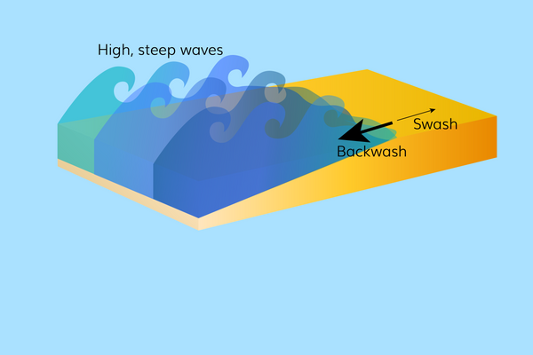
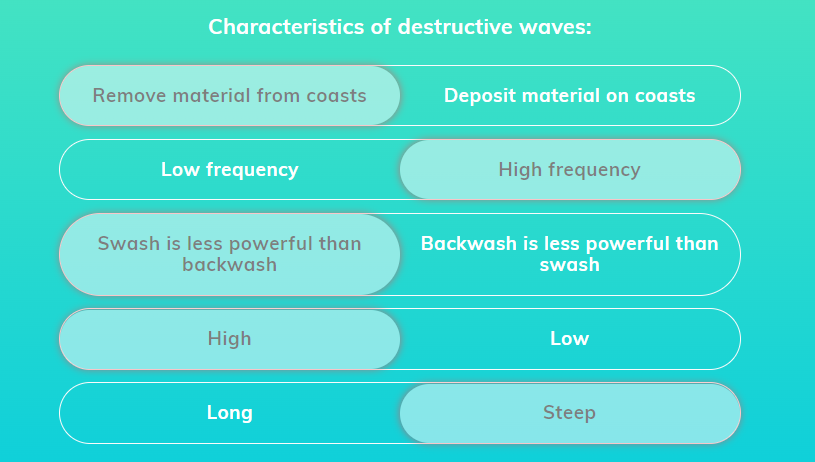
Destructive waves
* responsible for erosional processes
* high frequency (10-15 waves per minute)
* steep and high, with a circular motion so waves break at a greater height, causing the wave to ‘plunge’ and travel a shorter distance along the beach
* removes material from coasts because the swash is less powerful than the backwash
* high frequency (10-15 waves per minute)
* steep and high, with a circular motion so waves break at a greater height, causing the wave to ‘plunge’ and travel a shorter distance along the beach
* removes material from coasts because the swash is less powerful than the backwash
2
New cards
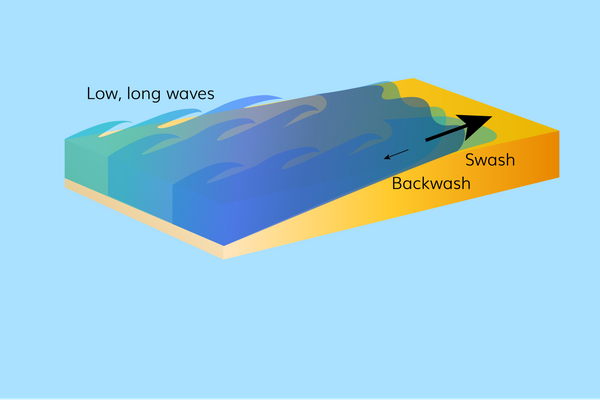
Constructive waves
* low frequency (6-9 waves per minute)
* long and low
* move in an elliptical motion, with waves having little height resulting in them ‘spilling’ and breaking out further along the beach
* forms gently sloping beaches by depositing material on coasts because the backwash is less powerful than the swash
* long and low
* move in an elliptical motion, with waves having little height resulting in them ‘spilling’ and breaking out further along the beach
* forms gently sloping beaches by depositing material on coasts because the backwash is less powerful than the swash
3
New cards
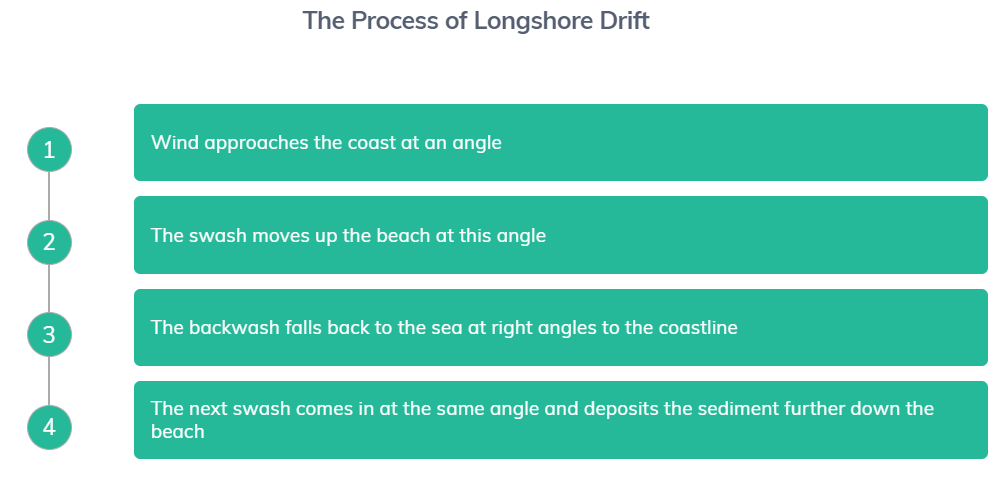
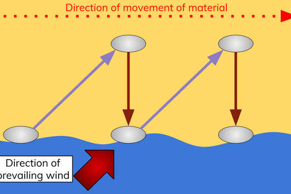
Longshore drift
transports material along coastlines when waves approach the beach at an angle
4
New cards
Swash direction
* wind approaches the coast at an angle because of a prevailing wind direction
* waves are controlled by the wind and so this angle will be the direction the swash moves up the beach
* waves are controlled by the wind and so this angle will be the direction the swash moves up the beach
5
New cards
Backwash direction
Gravity is the only force that acts on the backwash, so it falls back to the sea at right angles to the coastline
6
New cards
Swash and Backwash effect
* because of the difference between the angle of the swash and the angle of the backwash, sediment repeatedly moves in the shape of a right-angled triangle.
* over time, sediment is carried along a beach
* over time, sediment is carried along a beach
7
New cards
Erosion: Attrition
pieces of bedload (material carried in the water) are hit against one another causing them to break apart and become smaller and more rounded
8
New cards
Erosion: Hydraulic power
* causes the breakdown of cliffs due to the force of the water being compressed into the cracks of the rock
* the repeated action of the water forced in and out of the cracks in the rock leads to the breakdown of the surrounding cliff
* the repeated action of the water forced in and out of the cracks in the rock leads to the breakdown of the surrounding cliff
9
New cards
Erosion: Abrasion
pieces of rock are picked up by waves and hit against the bed, the beach or cliffs causing them to wear away over time
10
New cards
Erosion: Corrosion
a chemical reaction between the seawater (which contains a weak acid) and susceptible rocks like limestone
11
New cards
Headlands
made up of resistant rocks with weaknesses (joints and cracks)
12
New cards
Erosion of headlands (1)
destructive waves erode weaknesses in headlands by corrosion and hydraulic action
13
New cards
Erosion of headlands (2)
when the weaknesses in the rock widen, abrasion becomes more important
14
New cards
Erosion of headlands (3)
over time, these erosional processes lead to the formation of coastal landforms such as caves, arches, stacks and stumps
15
New cards
Caves
* erosion attacks lines of weaknesses in the headland
* when the crack widens into a small hollowed out area, a cave has formed
* when the crack widens into a small hollowed out area, a cave has formed
16
New cards
Arches
when caves are eroded through the headland, an arch is created
* E.g., Durdle Door on the Dorset Coast
* E.g., Durdle Door on the Dorset Coast
17
New cards
Stacks
when the top of an arch collapses because of gravity, a column called a stack is left behind
18
New cards
Stumps
* continued erosion and weathering cause the stack to breakdown, forming a stump
* at high tide, the stump can become submerged
* eventually, the stump will erode and there will be nothing left of it
* at high tide, the stump can become submerged
* eventually, the stump will erode and there will be nothing left of it
19
New cards
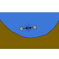
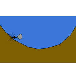
Formation: Wave-cut notch (1)
* cliffs are created when erosion, weathering and mass movement processes cause the undercutting and collapse of unsupported rock
* destructive waves are responsible for most of the erosion at the base of cliffs
* when destructive waves lead to abrasion undercutting the cliff face, a curved indent in the cliff forms and a wave-cut notch is created
* destructive waves are responsible for most of the erosion at the base of cliffs
* when destructive waves lead to abrasion undercutting the cliff face, a curved indent in the cliff forms and a wave-cut notch is created
20
New cards
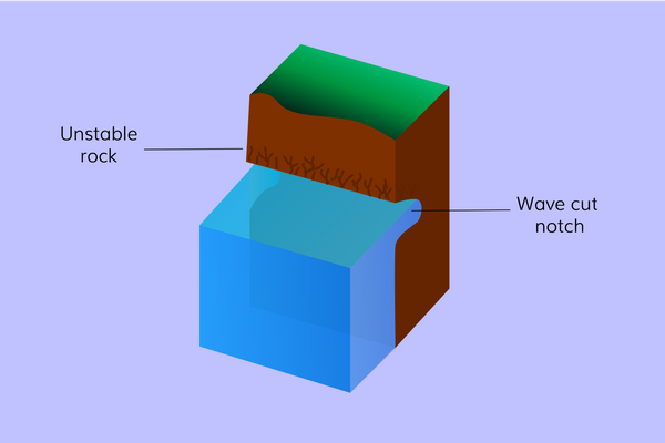
Formation: Collapse of wave-cut notch (2)
continued erosion of the wave-cut notch causes the rock above it to become less and less stable, until it eventually collapses
21
New cards
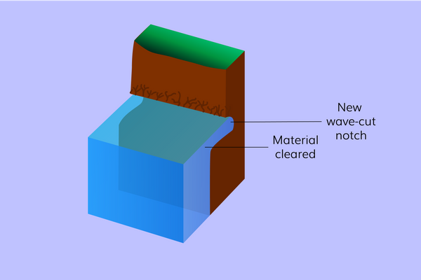
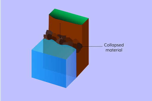
Formation: New wave-cut notch (3)
waves wash away the collapsed material and begin eroding away at the cliff again, causing a new wave-cut notch to form
22
New cards
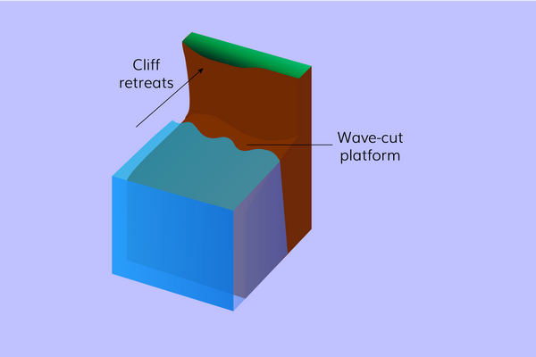
Formation: Wave-cut platform (4)
over time, multiple collapsing events lead to the cliff retreating, leaving behind a wave-cut platform
23
New cards
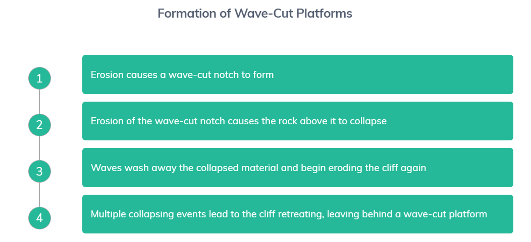
**Formation of Wave-Cut Platforms summary**
1. erosion causes a wave-cut notch to form
2. erosion of the wave-cut notch causes the rock above it to collapse
3. waves wash away the collapsed material and begin eroding the cliff again
4. multiple collapsing events lead to the cliff retreating, leaving behind a wave-cut platform
24
New cards
Weathering
breaking down of rocks where they are
25
New cards
Mechanical weathering
* rocks are broken down without their chemical composition being changed
* salt weathering is the main type of mechanical weathering affecting coasts
* salt weathering is the main type of mechanical weathering affecting coasts
26
New cards
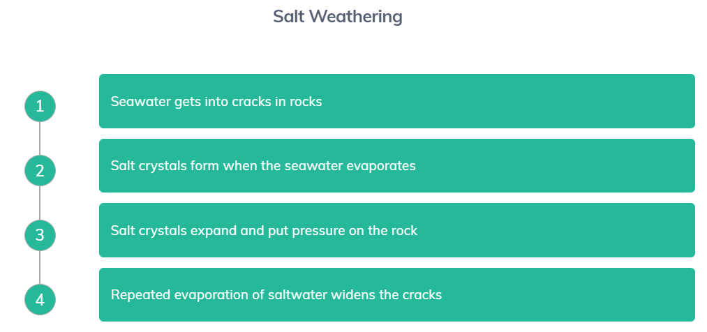
Mechanical weathering: Salt weathering
* seawater gets into cracks in rocks
* salt crystals form when the seawater evaporates. These crystals then expand and put pressure on the rock
* over time, the repeated evaporation of saltwater widens the cracks in the rock so much that the rock breaks apart
* salt crystals form when the seawater evaporates. These crystals then expand and put pressure on the rock
* over time, the repeated evaporation of saltwater widens the cracks in the rock so much that the rock breaks apart
27
New cards
Chemical weathering
rocks are broken down because of their chemical composition being changed
28
New cards
Chemical weathering: Carbonation
takes place when it is warm and wet
* carbon dioxide dissolves in rain, making it a weak carbonic acid
* the acidic rainwater dissolves types of rock that contain calcium carbonate
* carbon dioxide dissolves in rain, making it a weak carbonic acid
* the acidic rainwater dissolves types of rock that contain calcium carbonate
29
New cards
Biological weathering
rocks are broken down by living things
* e.g., plant roots get into cracks and push rocks apart as they grow
* e.g., plant roots get into cracks and push rocks apart as they grow
30
New cards
Littoral zone
* series of sub-zones to represent the features of the wider coastline from sea to land
* key sub-zones: offshore, nearshore, foreshore and backshore
* key sub-zones: offshore, nearshore, foreshore and backshore
31
New cards
Sediment cell
a closed system operated by sources, transfers and sinks driven by erosion, transportation and deposition processes
32
New cards
How many sediment cells the UK has
11
33
New cards
Sources
subaerial processes, erosional processes (breaking down cliffs) and sediments brought to the coastline by rivers
34
New cards
Transfers
longshore drift, onshore and offshore winds and tides
35
New cards
Sinks
depositional landforms (spits, bars, beaches and sand dunes)
36
New cards
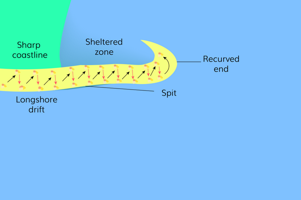
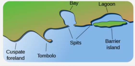
Depositional landform: Spits
* when the coast changes direction at an estuary (where a river meets the sea), longshore drift continues to move sediment across the inlet.
* the river doesn't let the spit completely join to the coast on the other side because the river has the energy to move the sediment
* often have salt marshes behind them
* the river doesn't let the spit completely join to the coast on the other side because the river has the energy to move the sediment
* often have salt marshes behind them
37
New cards
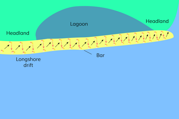
Depositional landform: Bars
* formed when a spit grows across a bay
* lagoons often form behind bars
* lagoons often form behind bars
38
New cards
Depositional landform: Beaches
* made by constructive waves moving and depositing sand or shingle inland
* a more gently sloping beach tends to be formed from sand, whereas a steeper sloping beach is formed from pebbles
* a more gently sloping beach tends to be formed from sand, whereas a steeper sloping beach is formed from pebbles
39
New cards
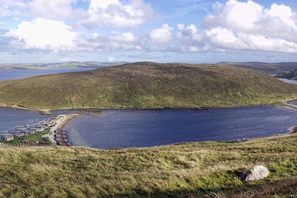
Depositional landform: Tombolos
when a spit stretches across the mainland and joins an offshore island
40
New cards
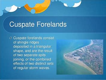
Depositional landform: Cuspate Forelands
* form when sediment is deposited across a bay caused by longshore drift transporting sediment in two directions
* leading to the formation of two spits which eventually meet and this then results in the trapping of sediment until eventually new land is formed
* leading to the formation of two spits which eventually meet and this then results in the trapping of sediment until eventually new land is formed
41
New cards
Dynamic equilibrium
balance between inputs and outputs
42
New cards
Littoral zone in/outputs
sediment is the key input and output of the system and is determined by:
* input - the action of waves, currents and wind
* output - washed out into the sea by erosion
* input - the action of waves, currents and wind
* output - washed out into the sea by erosion
43
New cards
High energy coast
destructive waves, long fetches, high rates of erosion, caves, arches, stacks and stumps, cliffs and wave-cut platform
44
New cards
Low energy coast
constructive waves, shorter fetches, higher rates of deposition, spits and bars, beaches, sand dunes and salt marshes
45
New cards
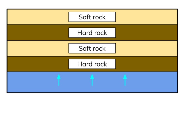
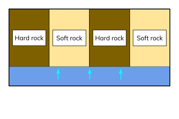
Concordant coastlines
alternating bands of hard and soft rock parallel to the coast
46
New cards
Concordant coastlines: Dalmatian coasts
made up of offshore islands and coastal inlets running parallel to the coastline
47
New cards
Discordant coastlines
alternating bands of hard and soft rock at 90o to the coast
* erosional landforms are more common on discordant coastlines because erosion happens at different rates along their length
* erosional landforms are more common on discordant coastlines because erosion happens at different rates along their length
48
New cards
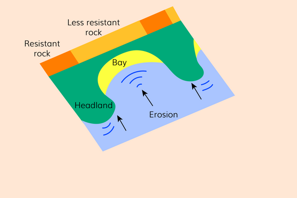
Discordant coastlines: Bays and Headlands
* the retreating, less resistant rock and the exposed resistant rocks cause a change in the shape of the coastline. This leads to wave refraction
* this change in the way in which waves approach the coastline can cause an increased rate of erosion on the headlands
* this leads to the formation of headland features like caves, arches, stacks and stumps
* this change in the way in which waves approach the coastline can cause an increased rate of erosion on the headlands
* this leads to the formation of headland features like caves, arches, stacks and stumps
49
New cards
Geological structure: Dips
* the angle the rock layer forms with the horizontal bedding plane is referred to as the dip.
* rocks can dip either towards land or towards the sea
* bedding planes that dip towards the sea create a gentler cliff profile (these cliffs are vulnerable to mass movement processes, e.g., rockfalls)
* bedding planes that dip towards land tend to create a steeper cliff profile (these cliffs are more vulnerable to erosion processes, e.g., hydraulic action and abrasion)
50
New cards
Geological structure: Joints and Faults
* geological structure of rocks (formation of joints, angle of dip, faulting and folding) is caused by the deformation and stress placed on them by tectonic processes
* rocks with more joints and faults (e.g., sedimentary rocks) are more susceptible to the processes of erosion and weathering. This is because these processes exert forces on the weaknesses found in the layers of the rocks
* rocks with more joints and faults (e.g., sedimentary rocks) are more susceptible to the processes of erosion and weathering. This is because these processes exert forces on the weaknesses found in the layers of the rocks
51
New cards
Bedrock lithology
physical properties of different rocks
52
New cards
Igneous rocks
* e.g., Basalt and Granite, form from the crystallisation of magma (more resistant to erosion and weathering)
* this is because igneous rocks contain crystals which increase the strength of the rocks and reduce the number of lines of weaknesses that would be exploited by physical processes
* igneous rocks can either be intrusive (formed from magma inside the Earth) or extrusive (formed when magma escapes through vents on the Earth’s surface)
* average rate of erosion of igneous rocks: 0.1-0.5 cm per year
53
New cards
Sedimentary rocks
* e.g., Limestone and Sandstone, form from the build-up, compacting and hardening of sediments into layers over time by lithification
* sedimentary rocks formed in a shorter geological time scale tend to be more susceptible to erosion and weathering and erode at a faster rate compared with those formed over a longer geological time
* average rate of erosion of sedimentary rocks: 2-6 cm per year
* sedimentary rocks formed in a shorter geological time scale tend to be more susceptible to erosion and weathering and erode at a faster rate compared with those formed over a longer geological time
* average rate of erosion of sedimentary rocks: 2-6 cm per year
54
New cards
Lithification
transform a sediment or other material into stone
55
New cards
Metamorphic rock
* e.g., Slate and Marble, are formed from the change in the structure of sedimentary and igneous rocks, caused by variations in heat and pressure
* Marble is an example of a metamorphic rock that has been formed from the changing structure of limestone caused by the re-crystallisation of calcite
* resistant to erosion
* Marble is an example of a metamorphic rock that has been formed from the changing structure of limestone caused by the re-crystallisation of calcite
* resistant to erosion
56
New cards

Sand dunes
* needs continuous supply of sand, powerful winds to transport sand and obstacles to trap the sand, like plants
* typical sand dune transect goes from the mobile dunes nearest the sea (embryo, fore and yellow) to the fixed dunes nearest the backshore (grey dunes and dune slack)
* dunes contain two types of plants:
* Xerophytes
* Halophytes
* typical sand dune transect goes from the mobile dunes nearest the sea (embryo, fore and yellow) to the fixed dunes nearest the backshore (grey dunes and dune slack)
* dunes contain two types of plants:
* Xerophytes
* Halophytes
57
New cards
Xerophytes
can withstand periods of dry weather
58
New cards
Halophytes
can withstand high concentrations of salt from seawater
59
New cards

Yellow dunes
colonised by marram grass (long deep roots and are salt tolerant
60
New cards

Embryo and Foredunes
colonised by sea rocket and sea crouch (deep roots and tolerate high concentrations of salt)
61
New cards
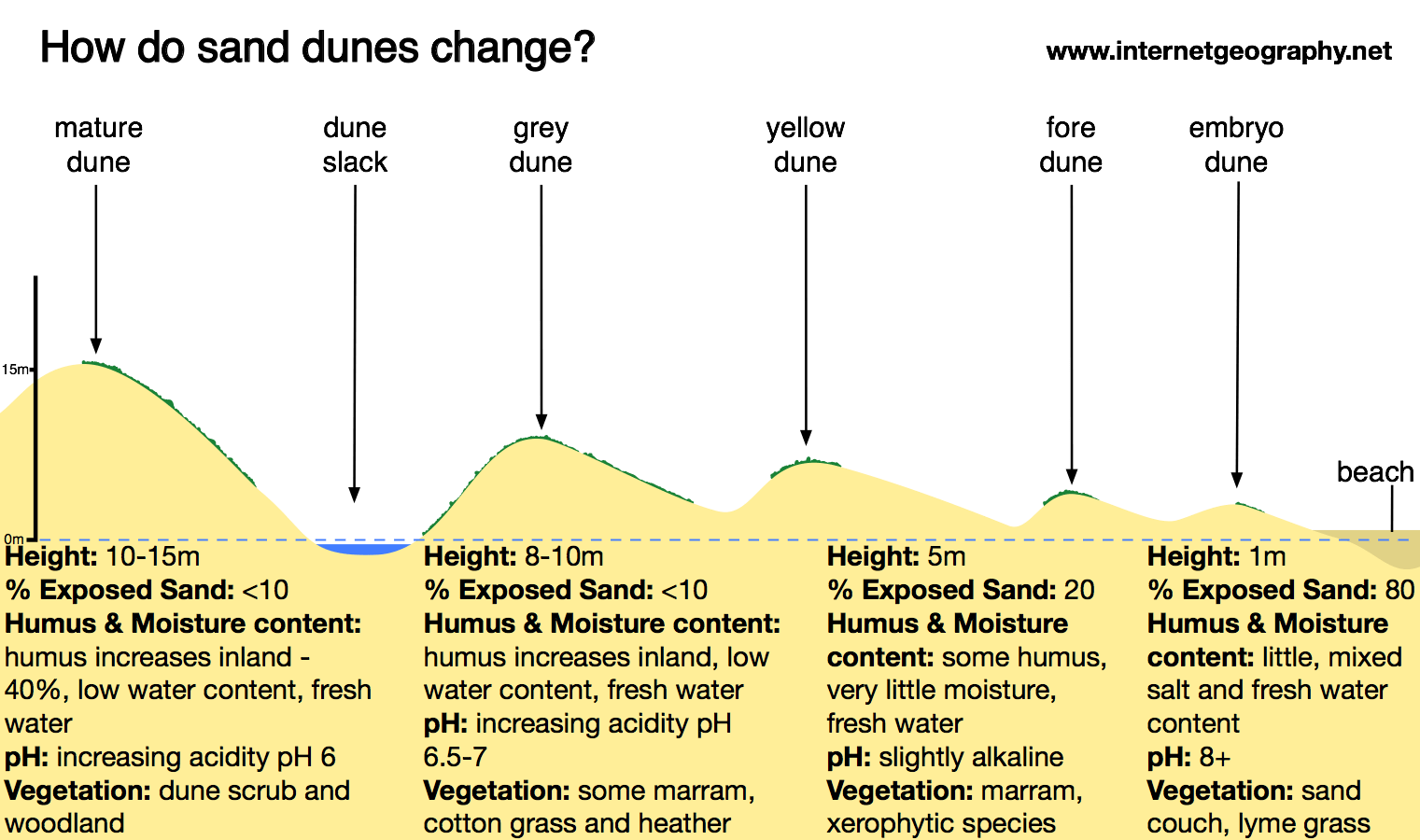
Grey dunes
colonised by heathers (higher rates of humus)
62
New cards
Humus
organic material that forms in soil when plant and animal matter decays
63
New cards
Mass movement
when rocks and loose material shift down slopes. This happens when gravity overcomes the force supporting the material. Mass movements can cause rapid coastal retreat and are common when the material is saturated
64
New cards
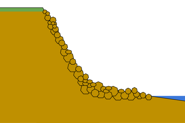
Mass movement: Rockfalls
* when material breaks apart because of erosion and weathering and then rolls down a slope
* the fallen fragments at the base of the cliff create talus scree slopes
* the fallen fragments at the base of the cliff create talus scree slopes
65
New cards
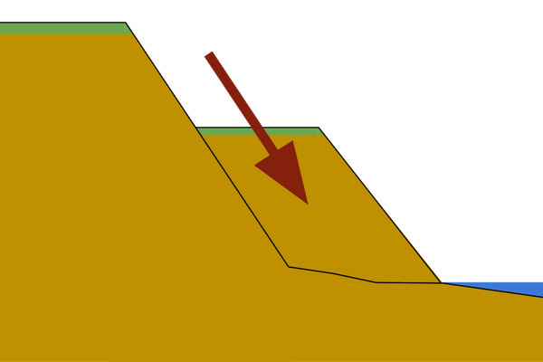
Mass movement: Slides
when material moves down a slope in a straight line
66
New cards
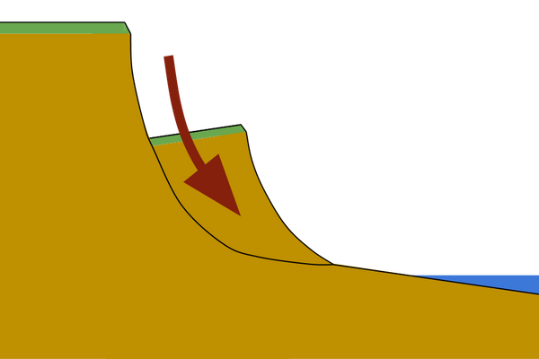
Mass movement: Slumps
* when material moves down a slope with a rotation
* happen slower than rockfalls and often happen when unstable permeable rock overlays more stable impermeable rock
* combination of heavy rainfall and erosion processes cause the rotational movement of the cliff
* happen slower than rockfalls and often happen when unstable permeable rock overlays more stable impermeable rock
* combination of heavy rainfall and erosion processes cause the rotational movement of the cliff
67
New cards
Sea level change: Eustatic change
* the rising and falling of sea levels, influenced by ice ages
* water is stored in the form of ice when the world is experiencing an ice age, which causes sea level to fall
* as the world moves out of an ice age, the ice melts resulting in sea level rise again
* water is stored in the form of ice when the world is experiencing an ice age, which causes sea level to fall
* as the world moves out of an ice age, the ice melts resulting in sea level rise again
68
New cards
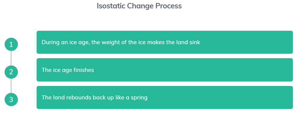
Sea level change: Isostatic change
* refers to the level of the land, which is also influenced by ice ages
* during an ice age, the weight of the ice forces the land to sink
* when the ice age has finished, the melting of the ice causes the land to rebound back up
* during an ice age, the weight of the ice forces the land to sink
* when the ice age has finished, the melting of the ice causes the land to rebound back up
69
New cards
Sea level change: Tectonic change
* causes land to either rise or sink at the boundaries where tectonic plates meet
* a sudden change in the movement of a plate can lead to a rise or fall in the seabed, causing a change in sea level (as well as tsunamis)
* a sudden change in the movement of a plate can lead to a rise or fall in the seabed, causing a change in sea level (as well as tsunamis)
70
New cards
Global warming
* changes in the world’s atmospheric temperatures are causing thermal expansion of the oceans, melting of glaciers and ice sheets
* global warming is largely because of anthropogenic greenhouse gas (GHG) emissions. The concentration of these gases has risen rapidly since industrialisation
* global warming is largely because of anthropogenic greenhouse gas (GHG) emissions. The concentration of these gases has risen rapidly since industrialisation
71
New cards
Climate change
* changing the frequency and intensity of low-pressure depressions and tropical storms
* rising global temperatures are causing our oceans to warm, triggering these low-pressure systems
* this increases the risk of coastal flooding and creates unusual weather conditions
* rising global temperatures are causing our oceans to warm, triggering these low-pressure systems
* this increases the risk of coastal flooding and creates unusual weather conditions
72
New cards
Increased frequency of storms (due to global warming)
* strong winds caused by storms create high energy, destructive waves which have considerable erosional power
* increased energy of the sea will mean more material can be transported and for greater distances. This could leave some areas vulnerable to erosion if they are left without much protection
* frequency of storm surges will increase. When combined with sea level rise, these surges will reach further inland and cause more damage
73
New cards
Rising sea levels
* some of the contributing factors being linked to the melting of glaciers and ice sheets
* e.g., the Greenland and Antarctic ice sheets have been decreasing rapidly
* higher sea levels could cause higher tides, which would increase the frequency of coastal flooding
* higher tides could also remove more material from beaches, leaving cliffs less protected
* e.g., the Greenland and Antarctic ice sheets have been decreasing rapidly
* higher sea levels could cause higher tides, which would increase the frequency of coastal flooding
* higher tides could also remove more material from beaches, leaving cliffs less protected
74
New cards
Emergent coastlines
* emergent coastlines cause the formation of raised beaches and fossil cliffs caused by isostatic rebound
* a raised beach and fossil cliff are formed when, following an ice age, the land rebounds. This causes the original height of land to increase
* this leaves behind a beach and fossil cliff higher than their original position
* e.g., in Fife, Scotland
* a raised beach and fossil cliff are formed when, following an ice age, the land rebounds. This causes the original height of land to increase
* this leaves behind a beach and fossil cliff higher than their original position
* e.g., in Fife, Scotland
75
New cards
Submergent coastlines
* submergent coastlines cause the formation of rias, fjords and Dalmatian coasts.
* Dalmatian coasts are formed because of the arrangement of alternating rock types parallel to the coast
* Dalmatian coasts are formed because of the arrangement of alternating rock types parallel to the coast
76
New cards
Ria
a flooded river valley formed when rising sea levels flood the valley, often creating an estuary
77
New cards
Fjord
a flooded glaciated valley formed when a glacier erodes vertically, creating a u-shaped valley.
* e.g., Lysefjord in Norway
* e.g., Lysefjord in Norway
78
New cards
Coastal recession: Subaerial processes
* weathering and mass movement processes combine to increase the rate of coastal recession
* long periods of rainfall weaken rock structure and in turn, leads to mass movement of material
* this collapsed material is then eroded and transported away by wave action
* long periods of rainfall weaken rock structure and in turn, leads to mass movement of material
* this collapsed material is then eroded and transported away by wave action
79
New cards
Coastal recession: Hard engineering
* construction of hard engineering structures at the coastline can disrupt sediment cells
* by disrupting one bit of coast, areas further along the coast may be starved of sediment supply, which can then result in the destruction of beaches
* by disrupting one bit of coast, areas further along the coast may be starved of sediment supply, which can then result in the destruction of beaches
80
New cards
Dredging
the removal of sediment for use in construction but has been linked to increased rates of coastal retreat
81
New cards
Coastal recession: Dredging
* removal of the sediment causes the depth of the ocean to increase
* this can cause an increase in the occurrence of destructive waves at the coast because they can maintain their energy further towards the shoreline
* this can cause an increase in the occurrence of destructive waves at the coast because they can maintain their energy further towards the shoreline
82
New cards
Rate of coastal recession: Tides
* tides are linked to gravitational pull. When the pull is at its strongest, there are high tides. When the pull is at its weakest, there are low tides
* during periods of high tide, the rate of coastal recession can increase because waves can reach further towards the shore
* during periods of high tide, the rate of coastal recession can increase because waves can reach further towards the shore
83
New cards
Rate of coastal recession: Weather systems
* influenced by areas of high pressure, creating anticyclones, and areas of low pressure, creating depressions
* increased belts of high pressure reduce the rate of coastal recession because this leads to calmer weather
* belts of low pressure systems cause unsettled weather condition
* seasons - winter recession is higher than summer recession because winter brings stormy weather, linked with higher tides and long wave fetch
84
New cards
Rate of coastal recession: Wind direction
* wind direction controls the movement of waves, influencing the rate of coastal erosion
* a dominant wind direction causes powerful destructive waves to attack the coastline
* this happens because the waves have travelled a long distance, influenced by the dominant wind, which is linked to the fetch of a wave
* a dominant wind direction causes powerful destructive waves to attack the coastline
* this happens because the waves have travelled a long distance, influenced by the dominant wind, which is linked to the fetch of a wave
85
New cards
Coastal flooding
a risk to millions of people today because many continue to live near coastlines for recreation and employment purposes. Low-lying coasts are at risk of flooding from local factors and global rises in sea levels
86
New cards
Bangladesh flooding
* storm surges threaten the lives of those living near the coast.
* rate of coastal erosion is expected to increase in the future if storm surge events continue to rise.
* risk associated with storm surges in the Bay of Bengal is because Bangladesh is so low-lying
* rate of coastal erosion is expected to increase in the future if storm surge events continue to rise.
* risk associated with storm surges in the Bay of Bengal is because Bangladesh is so low-lying
87
New cards
Maldives flooding
* the removal of mangroves is leading to an increased risk of flooding with increased wave height and less stable cliffs because there's a lack of roots in the soil
* several factors, such as waste disposal and logging, have caused the soil to lack roots
* the disturbance and removal of the mangroves is leading to increased wave energy and height because the trees would normally act as a barrier, helping to dissipate the wave’s energy before it reaches land
* several factors, such as waste disposal and logging, have caused the soil to lack roots
* the disturbance and removal of the mangroves is leading to increased wave energy and height because the trees would normally act as a barrier, helping to dissipate the wave’s energy before it reaches land
88
New cards
Consequences of coastal recession: Economic and social losses
* damage to houses and businesses mean that people are forced to relocate whilst repairs are done and financial support is needed for this
* many people in less developed countries have limited financial assets and are reliant on international aid
* in more developed countries, many people can't get enough insurance to cover potential damages, and many houses lose value as the rate of coastal recession increases
* many people in less developed countries have limited financial assets and are reliant on international aid
* in more developed countries, many people can't get enough insurance to cover potential damages, and many houses lose value as the rate of coastal recession increases
89
New cards
Maldives economic losses due to coastal recession
* one of the lowest lying countries in the world and at serious risk of being completely submerged due to of coastal flooding
* the islands rely on tourism for the local economy, but increased coastal flooding events threaten the physical features that cause many people to travel there
* coastal flooding also threatens housing and freshwater sources, which has forced many locals to migrate away from the annual flooding
* the islands rely on tourism for the local economy, but increased coastal flooding events threaten the physical features that cause many people to travel there
* coastal flooding also threatens housing and freshwater sources, which has forced many locals to migrate away from the annual flooding
90
New cards
Hard engineering: Rip Rap
a pile of boulders often placed in front of sea walls to dissipate the wave’s energy and support unstable rock structures
* long-lasting and relatively cheap
* but provide a hazard for people accessing the beach and have gaps between the rocks allowing erosion and weathering to continue
* long-lasting and relatively cheap
* but provide a hazard for people accessing the beach and have gaps between the rocks allowing erosion and weathering to continue
91
New cards
Hard engineering: Groynes
stone or wooden fences that stick out at 90o to the coast, stopping material being transported long distances by longshore drift
* create wider beaches, which slows down waves and so reduces erosion and flooding
* relatively cheap
* but beaches further down the coast get narrower, which means waves are not slowed down and erosion and flooding are more likely
* create wider beaches, which slows down waves and so reduces erosion and flooding
* relatively cheap
* but beaches further down the coast get narrower, which means waves are not slowed down and erosion and flooding are more likely
92
New cards
Hard engineering: Sea walls
hard concrete that deflects waves which are often curved to dissipate the wave’s energy and refract it back to the sea
* good long-term solution because of the resistance of concrete, leading to less maintenance
* but they create a strong backwash that can undercut the wall and they are expensive to build
* good long-term solution because of the resistance of concrete, leading to less maintenance
* but they create a strong backwash that can undercut the wall and they are expensive to build
93
New cards
Soft engineering: Beach reprofiling and nourishment
involves moving material to the upper sections of beaches from elsewhere, slowing down waves by widening beaches reducing the risk of erosion and flooding
* it maintains the beach for tourist use, supporting the local economy
* but removing sand and shingle from the seabed threatens certain organisms (e.g. corals)
* expensive and must be repeated
* it maintains the beach for tourist use, supporting the local economy
* but removing sand and shingle from the seabed threatens certain organisms (e.g. corals)
* expensive and must be repeated
94
New cards
Soft engineering: Cliff regrading
cliff re-grading and drainage involves restructuring and supporting the cliff to prevent further collapse from weathering and mass movement processes
* maintains the cliff and provides a natural environment for plant and wildlife to continue to flourish
* but there are risks associated with altering cliff profiles which can lead to further collapsing and unintended changes to the profile
* maintains the cliff and provides a natural environment for plant and wildlife to continue to flourish
* but there are risks associated with altering cliff profiles which can lead to further collapsing and unintended changes to the profile
95
New cards
Soft engineering: Dune stabilisation
the creation or restoration of sand dunes to maintain their protective position through nourishment or planting vegetation
* This provides a natural barrier to coastal flooding and can support wildlife habitats
* But only a small area is protected and it is ineffective in preventing wave action during powerful storm
* This provides a natural barrier to coastal flooding and can support wildlife habitats
* But only a small area is protected and it is ineffective in preventing wave action during powerful storm
96
New cards
ICZM - integrated coastal zone management
holistic approach to coastal management
* involves careful consideration of the most effective management approach for a stretch of coastline
* It considers the social, economic and environmental implications
* involves careful consideration of the most effective management approach for a stretch of coastline
* It considers the social, economic and environmental implications
97
New cards
Stakeholders (factors of consideration for ICZM)
* proposed risk to residential, commercial and industrial buildings
* implication of coastal recession on the local economy
* impact of coastal recession and flooding on the natural environment
* implication of coastal recession on the local economy
* impact of coastal recession and flooding on the natural environment
98
New cards
ICZM benefits
* promotes the careful conservation of the natural environment
* encourages the efficient use of resources to reduce unnecessary costs
* tries to reduce the potential loss to the various stakeholders that rely on coastal regions for their livelihood
* encourages the efficient use of resources to reduce unnecessary costs
* tries to reduce the potential loss to the various stakeholders that rely on coastal regions for their livelihood
99
New cards
SMP - shoreline management plan
devised by key organisations (e.g., local government/council) to determine the most appropriate management strategies for a stretch of coastline
* has 4 key management approaches
* has 4 key management approaches
100
New cards
SMP: Advance the line
the construction of new engineering techniques to protect the coastline from further recession