Comprehensive Planning and Urban Design
1/63
There's no tags or description
Looks like no tags are added yet.
Name | Mastery | Learn | Test | Matching | Spaced |
|---|
No study sessions yet.
64 Terms
Regional Planning
It is a branch of land use planning and deals with the efficient placement of land use activities, infrastructure, and settlement growth across a significantly larger area of land than an individual city or town.
Spatial Planning
It refers to the methods used by the public sector to influence the distribution of people and activities in spaces of various scales.
Urban Structure
It is the arrangement of land use in urban areas.
Urban Design
It is the design of towns and cities, streets and spaces. It is the collaborative and multidisciplinary process of shaping the physical setting for life - the art of making places. Urban design involves the design of buildings, groups of buildings, spaces and landscapes, and establishing frameworks and procedures that will deliver successful development by different people overtime.
Image of the City
It is a 1960 book by American urban theorist Kevin Lynch. In an any given city, a corresponding set of mental images exist in the minds of the people who experience that city. Contributing to those images are five qualities which Lynch identifies.
Paths
Channels by which people move along such as roads, sidewalks and rails.Strong paths should be:
Edges
These are dividing lines between 2 phases such as seashores, railway lines. These are not dominant as paths but are important organizing features of the city.
Districts
These are medium to large sections of the city, characterized by wealthy neighborhood such as suburbs, college campuses. Its dominance will depend upon the individual and the given district.
Landmarks
Point of reference and it makes a person orient oneself. Examples are signs, famous buildings,established stores
Nodes
Area of strategic spots where extra focus is given such as busy intersection , popular city center, etc. These are typically formed by an intersection of linear elements such as paths.
Ian Bentley Responsive Environment
It is as an alternative approach to urban design which aims to maximize the degree of choice available to end -users of a built environment by offering sevendesign qualities:
Permeability
It affects where people can go, and where they cannot. Only places which are accessible to people can offer them choice.

Variety
The range of uses available to people.
Variety
The range of uses available to people. Variety of use unlocks the other levels of variety:
Legibility
How easily people can understand what opportunities it offers. It is important at two levels, physical formand activity patterns, places may be read at either level separately.
Robustness
the degree to which people can use a given place for different purposes. Environments that offer this choice have aquality called robustness. Two sorts of areas need special attention namely, Hard or Soft and Active or Passive.
Visual Appropriateness
Detailed appearance of the place make people aware of the choices available.
Richness
People's choice of sensory experiences. Dealing with the smallest details of the project. The planner must decide whereabouts in the scheme to provide richness, both visual and non-visual, and select appropriate materials and constructional techniques for achieving it. Visual richness depends on the presence of visual contrasts in the surfaces concerned.
Personalization
the extent to which people can put their own stamp on a place. Personalization is not random. Personalization clarifies the gist of designing to meet someone’s requirements.
Grid Theory
The grid plan, grid street plan or gridiron plan is a type of city plan in which streets run at right angles to each other, forming a grid. In the context of the culture of Ancient Greece, the grid plan is called Hippodamian plan (named after Hippodamus of Miletus).
Concentric Zone Theory
Proposed by Ernest Burgess. Also known as Burgess Model or CCD Model (Central Concentric Development).This concentric ring model depicts urban land usage in concentric rings: the Central Business District (or CBD) was in the middle of the model, and the city is expanded in rings with different land uses.
Sector Theory
It is a model of urban land use proposed in 1939 by land economist Homer Hoyt. It is developed under the premise that other uses grow with the CBD. It is consistent with the observation that most cities grow in the direction of higher income.
Multiple Nuclei Theory (Polycentric)
It is an economical model created by Chauncy Harris and Edward Ullman in the 1945 article “The Nature of Cities". Uses do not evolve around a single core but at several nodes and foci. Recognizes that difference activities have varying accessibility requirements.
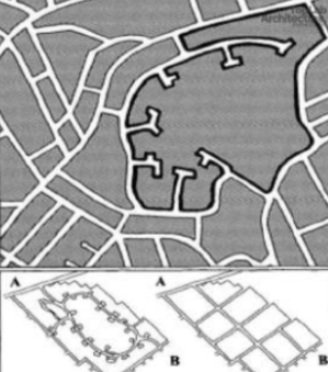
Urban Form
Refers to the physical layout and design of the city. It is the spatial imprint of an urban transport system. Also defined as “the spatial pattern of human activities at a certain point in time".
Landform
As Topography and Relationship with Nature
Shapes
Radiocentric, Rectilinear, Star, Ring, Linear, Branch, Sheet, Articulated Sheet, Constellation, and Satellite.
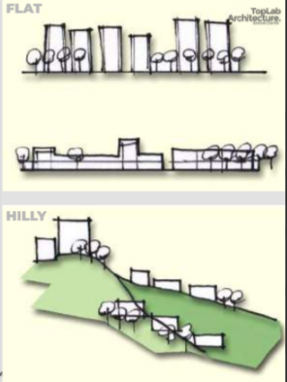
Topography
Flat or Hilly
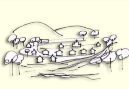
Cities within Nature
Refers to urban environments that prioritize integrating natural elements and ecosystems into the built environment, creating a harmonious coexistence between humans and nature
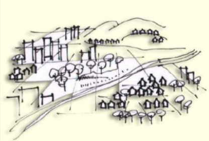
Cities and Nature
Encompasses the complex relationship between urban environments and the natural world
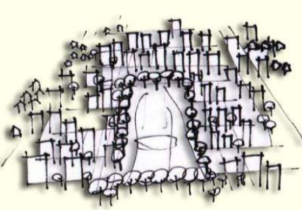
Nature within Cities
Refers to the integration of natural elements and systems into urban environments.

Radiocentric
The most frequently found urbanform is the radiocentric, a large circle with radial corridors of intense development emanating from the center.
Rectilinear
A variation on radiocentric form is the rectangle,which usually has two corridors of intense development crossing at the center. This variant of the radiocentric form is found in small cities rather than large. It is the radiocentric form with right angles.
Star
A radiocentric form with open spaces between the outreaching corridors of development.
Ring
A city built around a large open space. A ring and star may be found in combination, particularly where aloop road is built around the outskirts of an expanding metropolis.
Linear
The result of natural topography which restricts growth or the result of a transportation spine. Stalingrad in the Soviet Union was planned as a linear city. The megalopolis on the East Coast has become a vast metropolitan area with a linear configuration.

Branch
Is a linear spine with connecting arms.
Sheet
A vast urban area with little or no articulation.
Articulated Sheet
Is accented by one or more central clusters and several subclusters.
Constellation
Is a series of nearly equal-size cities in close proximity.
Satellite
A constellation of cities around a main center.
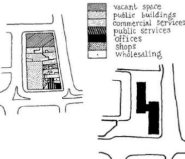
Urban Design Controls
These are tools by which urban design strategy is reinforced and implemented. These are design elements of both private and public spaces coordinated in a way to reinforce the place identity and bring about a sense of community.
Floor Area Ratio
The proportion between the built area and the lot area.
Floor Space Index
It is the ratio of total floor area of a building to the total plot area. This numeric value indicates the total amount of area you can built upon a lot.
Incentive Zoning
It means a zoning in which an incentive such as relaxation in zoning restrictions are offered to a developer for providing public benefit like building a desired public improvement, or building in areas that requires economic development.
Cluster Zoning
It is the special zoning policies and regulations for medium to large sized controlled developments. A type of zoning in which density is determined for an entire area,rather than a lot-by-lot basis.
Building Height
It is the maximum height allowed for building/structures based on their proposed use or occupancy. BHL is generally determined from the established grade line to the top most portion of the proposed building structure.
Setback
Is the width of the yard.
Yard
Is the required open space left between the outermost face of the building / structure and the property lines.
Building Bulk
Itis the overall size of the proposed building/structure as initially characterized by the gross floor area or the total gross floor area by the overall dimensions of its allowable maximum building footprint by its height as dictated by the building height limit andalso by the extent of allowable projections.
Architectural Character
Character refers to all those visual aspects and physical features that comprise the appearance of every building.
Environmental Impact Assessment
These are required for large projects. Developers are asked to outline possible effects of the project on the environment.
Urban Renewal
A general term to describe the idea of consciously renewing the outworn areas of towns and cities; covers most aspects of renewal, including both redevelopment and rehabilitation.
Adaptive Reuse
Converting old , usually historic buildings, sections of, or entire districts to new uses other than their original purpose. In many U.S. cities adaptive reuse is encouraged by special tax incentives
Rehabilitation
Term used to describe the idea of repairing, redecorating and in some cases converting, existing structurally sound property to a standard compatible with modern requirements of amenity and health.
Invasion
A type of urban ecological process defined as the entrance of a new population and/or facilities in an already occupied area.
Blockbusting
“Forcing” the old population out of the area because of social or racial differences.
Centralization
An urban ecological process in city land use patterning referring to an increase in population at a certain geographic center.
Gentrification
Improving the physical set-up and consequently affecting the market for previously run-down areas.
Planned Unit Development (PUD)
Referred as cluster zoning. Typically consists of variety of uses, anchored by commercial establishments and supported by office and residential spaces. Ordinary zoning regulations can be suspended for PUDs.
Transit Oriented Development (TOD)
It is defined as urban development that maximizes the amount of residential,business and leisure space within walking distance of public transport.
Rural TOD
Located on a local or feeder bus line that will allow residents to travel to the main transit stop within 10 minutes (3 miles). Development type: moderate density residential, service, retail, civic, and recreational uses
Urban TOD
Located directly on the trunk line transit network (e.g. light rail, heavy rail,or express bus stops). Allows direct access to the transit system without requiring them to transfer.
New Urbanism
itis a planning and development approach based on the principles of how cities and towns had been built for the last several centuries: walkable blocks and streets, housing and shopping in close proximity, and accessible public spaces.
Sprawl
Is the expansion of human populations away from central urban areas into previously remote and rural areas, often resulting in communities reliant upon heavy automobile usage.