Natural Disasters Final Exam (UIowa Spring 26)
 Call Kai
 Learn
Learn Practice Test
 Spaced Repetition
 Match
Match Flashcards
 Knowt Play
1/141

There's no tags or description
Looks like no tags are added yet.
Name | Mastery | Learn | Test | Matching | Spaced | Call with Kai | Chat |
|---|
No analytics yet
Send a link to your students to track their progress
142 Terms
Drought
period of drier-than-normal conditions that results in water-related problems:
• Soils dry out
• Plants can die
• Streamflows decline
• water levels in lakes and reservoirs fall
• depth to water in wells increases
Causes of drought
Ocean temperatures
• Changes in the jet stream
• Changes in the local landscape
Great Famine 1976-1978 India
caused by drought and inflicted crop failure in India’s Bread Basket.
part of an even larger cluster of drought caused famines in India, Africa, and South America that killed over 50 million people
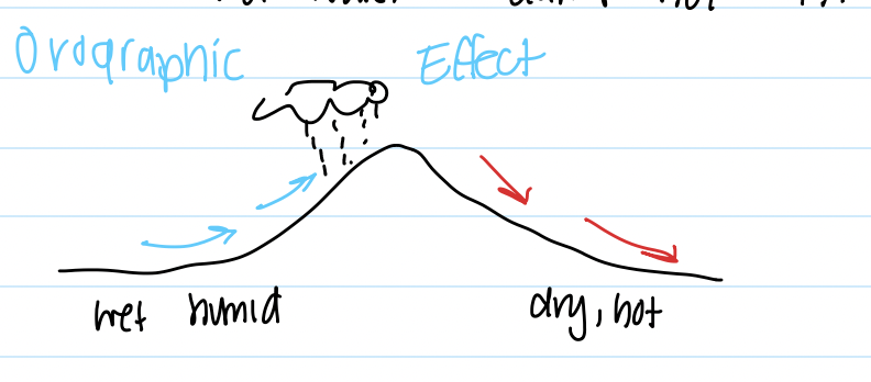
Orographic effect
Wet, humid air is pushed up by the Sierra Nevadas
• As it rises, it cools resulting in precipitation.
• Winter precipitation is stored as snow until the spring melt, when it runs down and is
stored in reservoirs for use during the summer.
Wildfires
unplanned fires that burn in natural areas, such as grasslands, shrublands, forests,
or other environments, including wildland areas where people live. The number and size of these
fires are increasing (fire season lengthening, burnable area)
Causes of wildfires
Natural causes:
• Lightning
• Meteors
• Coal seam fire: oxidation of organic matter in coal can cause it to spontaneously ignite
Human causes (90% of wildfires are human caused):
• Burning waste
• Unextinguished campfires
• Target shooting
• Fireworks
• Powerlines
• Cigarettes
• Arson
• Vehicles- flat tires, dragging chains, exhaust systems
• Children playing with matches
Fire triangle
Oxygen: windy conditions
2) Heat: high air temperatures and sun (high radiant energy)
3) Fuel: combustible materials, dry (makes them more combustible)
o Some wood/materials burn better
California Drought 2011-2022
wetter air force N> led to dry conditions and less snow
Orographic effect
resulted in huge depletion of food and power
CA grows 13% of our food (#1 food grower)
Professor Swanson facts
almost set fire to Mr Setnal in a camping gas stove explosion
Took field trip to Missouri
Wife is from Helena, Montana
Bob is his sons name
Beleives in aliens (infite possibilities in the universe)
What happens when wood burns
wood is glucose> breaks down itno CO2 and H20 to make more heat (exothermic reaction)
To stop, remove O2 or heat (pour water)
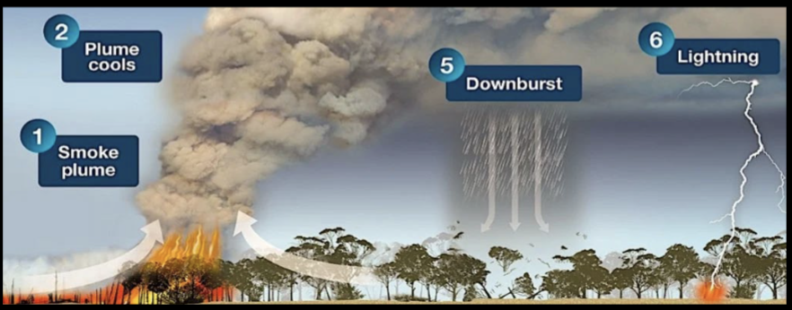
Dangers of wildfires
Heat generates its own convection/weather that keeps fires going
updrafts
high winds
ash rain
lighting > charged particles
smoke (gases + fine, toxix particles)
Damaged soils
• Difficult for forests to regenerate after organics burn
• Many areas left unsuitable for agricultural use
• Bare soils susceptible to erosion and Mass Wasting
• Tons of soil washed into nearby streams
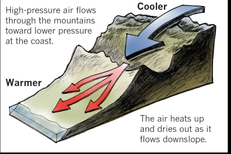
Local Winds - Katabatic Wind
Colder Air at higher elevations (especially over ice and snow) sinks (high pressure), and flows into the valley where it warms and rises (low pressure)
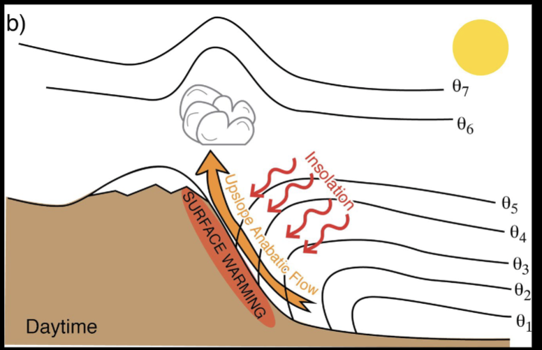
Winds- Anabatic wind
Solar Radiation Warms hillslopes and causes air to warm and rise,
drawing air from Valley up the Mountain Slopes
Smoke
• Wildfire smoke is a mix of gases and fine particles from burning vegetation, building materials, and other materials.
• Older adults, pregnant women, children, and people with preexisting respiratory and heart conditions may be more likely to get sick if they breathe in wildfire smoke.
• Wildfire smoke can make anyone sick. Even someone who is healthy can get sick if there is enough smoke in the air.
• Breathing in smoke can have immediate health effects
How to put out fire
1) Reduce heat: lower temperatures and precipitation eventually are what kill large fires
2) Reduce oxygen availability: most wildfire fighting includes both large amounts of water and chemical retardant slurries. These mostly coat or drown materials so they have less access to oxygen and can’t ignite or continue burning
3) Reduce fuel: firefighters rely on mechanical means and back burns to remove fuel in front of fires to control them, so they have no fuel to keep them going
Benefits of wildfires
Many plant and animal species have evolved with fires and fire has become an important management tool:
• Fires clean out dead organic matter and understory, promoting tree growth
• Fires provide nutrients more directly to the soil so they are more available for plant growth
• Certain species require fire for germination
ex. Controlled or prescribed burns reduce fuels for fires
Stream/river
convergence of water flowing within a channel or floodplain.
• Channels generally take on a form (width / depth / slope) that will efficiently carry the water and sediment supplied from upstream on a regular basis.
• Rivers are larger versions of streams or creeks
Stream uses
drinking water
irrigation
industry
transportation
recreations
energy
How are streams formed
Evaporation
• Transpiration
• Precipitation (About 22% lands on land)
• Sublimation
• Infiltration / Percolation
• Melting
• Runoff (Stream flow)
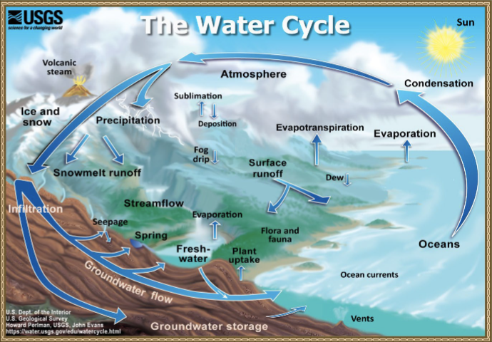
Watershed
A watershed is an area of land where all of the incoming precipitation runoff drains (i.e., “sheds”) to the same place – toward the same body of water or the same topographic low area – as a result of its topography.
water moves through network of drainage pathways (moves water & SEDIMENT
Watershed divisions (Continental Divides)
defined by high points/ridges and low points (outlets)
divided into smaller watershed or combined into continental scale watersheds
Continental divides separate drainages that flow to different major water bodies
(e.g., Gulf, Atlantic, Pacific)
Overland flow
Overland flow occurs when
1. the rainfall intensity exceeds the infiltration capacity of the soils
( infiltration capacity = the rate a soil can take on water or water can percolate into a soil)
OR
1. When the soils are saturated and can’t hold any more water
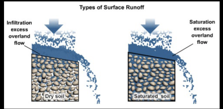
Runoff Generation
1) Water fills surface depression then
2) Water spills over downslope as overland flow and
3) Eventually runs to the stream
4) Runoff depends on rainfall, surface roughness, soils and soil density, and soil water content
Overland flow
Channel Formation Begins with sediment detachment: requires a force (shear) created by small eddies in flow caused by changes on the land surface or raindrop impact, and an increase in water depth
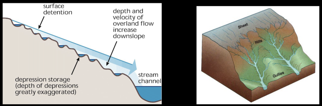
Drainage Network
Over time, a drainage network develops
1. Runoff coalesces into sheetwash
2. Sheetwash erodes the substrate, forming channels (rills and gullies)
3. Channels deepen by downcutting and lengthen via headward erosion
4. Smaller channels are captured by larger channels
Surface runoff
Sheetwash is a thin, mobile sheet of water that flows over the surface of a hill-slope and may transport the surface material.
Sheet erosion concentrates and forms new, small channels less than a few inches deep and wide (erosional). These channels are called rills. Rills erode and coalesce to form gullies.
Rills and gullies can remove a lot of sediment.
Stream flow
Discharge
The volume of water flowing in a channel
• Volume of water passing a point per unit of time
Discharge = Area of Water (width x average depth) x velocity
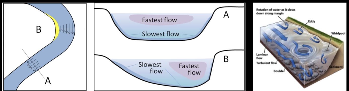
Channel Velocity
Velocity is not uniform in a channel
o In straight sections, the strongest flow in the middle, towards the top
o In beds, the strongest flow is on the outside of the bend
Hydrographs
show discharge over time
Hydrographs vary:
o From day to day: precipitation, snow melt, evapotranspiration
o Year to year: droughts, major floods
o And place to place
Stream Flow velocity
• Velocity ~ (AvgDepth(2/3) * Slope(1/2))/Roughness
• Velocity increases with slope and(or) depth
• Velocity decreases with increased roughness
Storm Hydrographs
o Show discharge changes following a precipitation event
o Provides information on how fast the runoff collects and how long the rainfall
impacts flow in the channel
Generally steeper on the rising limb and more gradual on the falling limb
Baseflow
groundwater fed to a creek that maintains a relatively constant minimum flow
Storm flow
water added to the creek via shallow groundwater and runoff after rain begins
Saturated Overland Flow
water added to a creek once soils are filled with water
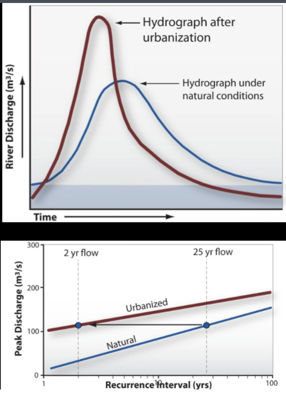
How does urbanization affect hydrographs?
Before Development
water held in storage by pit & mound topography
infilitrates slowly w/smaller flood peaks
After:
• Infiltration became limited
• Runoff builds rapidly and enters streams quickly
• Baseflow limited (need infiltration to get gw)
• Flood peaks are larger and occur sooner
• Larger flood magnitudes become more frequent
(e.g., once every 10 or 25 years now occurs once
every 2 years)
• Channel Degradation!!
Work of running water
The energy of flowing water comes from its mass and gravity
• Streams convert potential energy to kinetic energy as they flow downslope.
• The more kinetic energy, the more a channel can slide, lift, or move solids
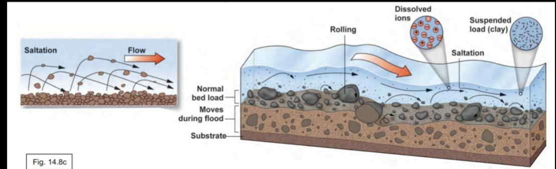
Sediment transport
Sediment load = material moved by running water
• Dissolved load – ions from chemical weathering
• Suspended Load – fine particles (silt and clay) floating in the water
• Bed Load – larger particles that roll, slide, and bounce along the bottom
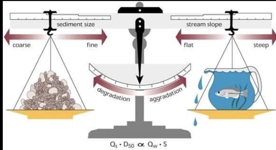
Lane’s balance
Streams adjust their channel form to balance the energy of the flow and the amount of work they need to do.
• Too much energy (increased flow) and they erode (degrade).
Too much work (increased sediment) and they fill in (aggrade).
How strong are streams
Stream Strength Depends on Water Depth, Stream Slope (mass and gravity again), and the area of an object exposed to the flow.
Floods can move sand, gravel, cobble, boulders, humans, cows, trees, cars, homes, etc.
1-2 ft of water can be enough to sweep away a car
Braided Streams
• Main stream consists of many interfingering channels
• High Sediment Load and shallow water.
• Constantly shifting sand and gravel bars (deposits)
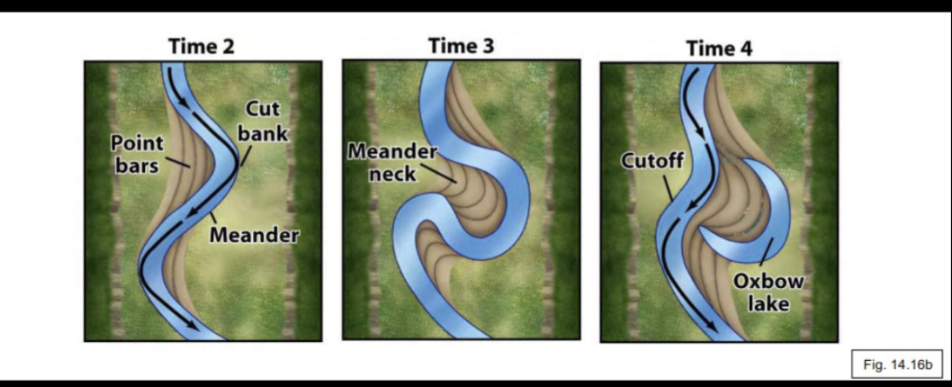
Meandering streams
• Sinuous, looping curves (meanders)
• Usually, the gradient is relatively low, high depth and flow
• Stream occupies a broader floodplain
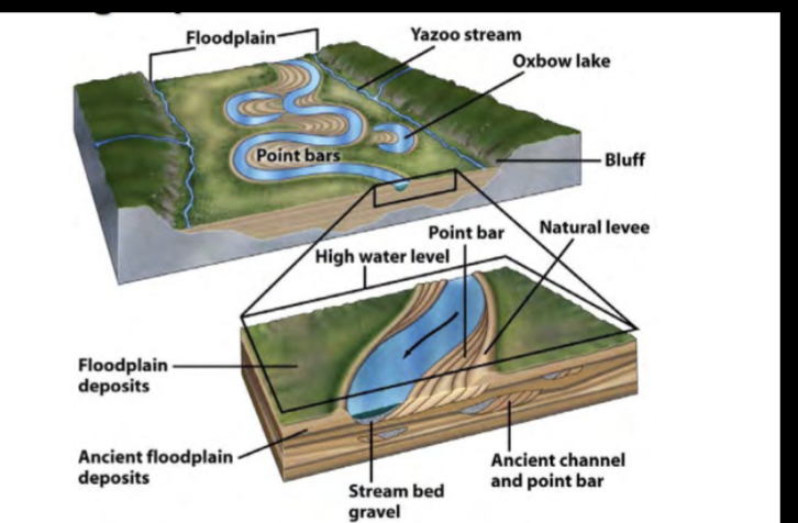
How do meandering streams change
• Modified during periods of high flow
• Fast water erodes the outside of the curve
• Slower water deposits point bars on the inside of the curve
• Cutoff Meanders at Pinch Points
• Leave behind Oxbow Lakes (abandoned meanders)
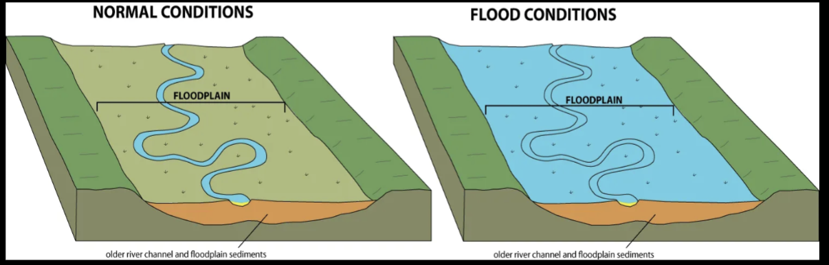
Floodplains
Areas of water and sediment
storage adjacent to channels, that
experience frequent flooding.
• Formed by the river migrating back
and forth across its valley.
• Rivers often only occupy a small part
of their floodplains
• During floods, the entire floodplain
may be immersed
Floods
1) An event where water submerges normally dry land
2) Any stream flow event where water spills out of its main channel
How do floods occur
• Most floods occur during prolonged rain that saturates the ground, leading to excessive
runoff
• Torrential rains can rapidly dump large volumes of water quickly
• Rapid snowmelt across a large watershed
• Failure of a dam and levee
Flash flood
A flood caused by heavy or excessive rainfall in a short period of time,
generally less than 6 hours
• Fast flowing, turbulent flows following heavy rains (little warning!!)
• Occur along river beds, urban streets, or mountain canyons
Where do flood occur?
Anywhere
Evaluating flood hazards
Flood risks are calculated as annual probabilities and recurrence intervals:
• Recurrence interval = average number of years between floods of a particular size
o Reflects the size of the flood
What is the chance of an 100-year flood any year?
1%
Recurrence interval is the average number of years between floods of a particular size (1/100= 0.01= 1%)
Flood mitigation
Flood mitigation involves the engineering management of flood water
movement
AND
the management of people through evacuation measures, flood proofing
properties, and zoning
Physical flood mitigation
• Dams
• Floodwalls and flood gates
• Levees
• Canals
Tricky and often compound a disaster
• Dam breaks
• Katrina and Levee Breaks
• 1998 Mississippi Floods
Federal Emergency Management Agency
in charge of evaluating flood hazards. More locally, this is the Iowa Flood Center.
Both agencies:
• Collect hydrologic data
• Make flood-hazard maps
o Many of these maps are deficient and outdated
Flood management and society
• Local and Regional Evacuation Management
• Organize Citizens for Sand bagging/Protection and Rescue Operations
• Zoning for Flood Prone Areas
• Require stilts, water proofing measures, etc.
• Make zoning equitable…deal with social/environmental justice issues
• Find better uses for Floodprone Areas
• Parks and Rec,
• Flood Proof Agriculture (e.g., rice, poplars, hippos?)
Flooding for good
Though floods can be devastating to population centers, they have always been an integral part of healthy riverine/fluvial ecology.
• Renewal of Wetlands
• Nutrient Regeneration
• Preventing Erosion
• Maintaining Surface Elevations
• Recharge Groundwater
Nile Delta
• Far fewer floods = less nutrients and water in flood plain and on delta = diminished agriculture
• Fewer Floods on the Delta means less sediment, so the delta is sinking with no new sediment to fill it in and saltwater intruding to the south
• Pollutants Build Up along Channel and in the Delta
River ecosystems
Animal and Plant Communities Depend on Frequent Disturbances to the floodplain for their lifecycles (habitat mosaic).
• Groundwater-surfacewater
interactions
• Heterogeneous Habitats
• Nutrient and Oxygen Exchange
Mass Wasting
Mass wasting is the downhill movement of masses of bedrock, rock debris, or soil under the pull of gravity
Until recently, more costly over time in US than others (now hurricanes)
Landslides,
• Rock Falls,
• Debris Flows
• Avalanches
• Creep
• Slumps
Slope Stability
Slopes can be stable or unstable
Slope stability is a trade-off b2wn 2 forces
gravity pulling down
material properties resisting motion (friction, roots, etc)
Movement occurs when downslope forces are greater thna resisting forces
Factors influencing slope stability
Gravity is great leveler (tearing mountains down)
Mass Movement occurs anytime downward pull of gravity overcomes
cohesion and frictional forces resisting it
Factors making mass wasting likely
– Steep slopes (higher stress)
– Large relief (higher stress)
– Weak Rock Layers (low material strength)
– Thick layer(s) of loose rock,
debris, soil (low material strength)
– Presence of water (friction, material strength)
– Lack of vegetation (low material strength)
– Seismic (earthquake) activity
steep slopes
Downslope forces = gravity
• Wight of earth materials, added water, or added structures
• Steeper slopes have less normal forces (straight into the underlying material) to offset
gravity
Resisting forces = material strength
• Cohesion: chemical bonds, electrical charges, surface tension
• Friction and normal force
Steeper slopes require larger resisting forces to remain stable.
How do you get mass wasting
To get mass wasting :
1. Increase the shear stress (increase loading, slope)
2. Decrease the material strength (fracturing/weathering)
3. Decrease Friction (water and clay)
High relief
Relief- lrg elevation change from top of mountains/hills to valley floor
Failures, epecially large failures and disasters, are more likley to occur where there are more and longer steep slopes
larger, longer, steeper slopes provide more material moving at faster speeds, which can cause more dmage
Regolith
blanket of loose deposits covering solid rock (clay , silt, broken rocks)
more regolith = greater chance of mass wasting
Weak rock layers
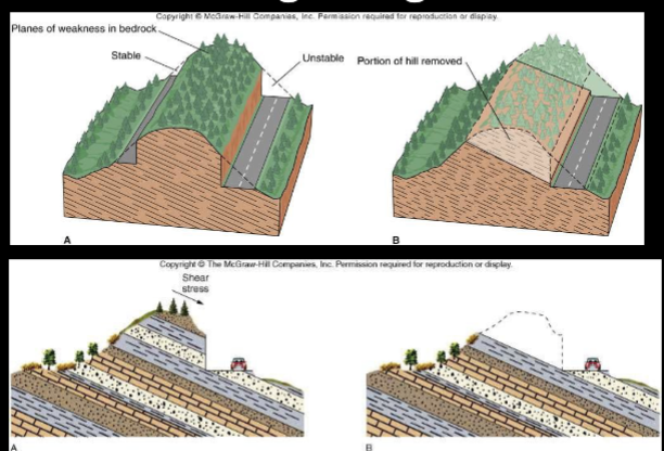
Weak subsurface layers can increase likelihood of failure or motion
joints/fractures parallel to the surface
weak sedimentary bedding (clay, shales)
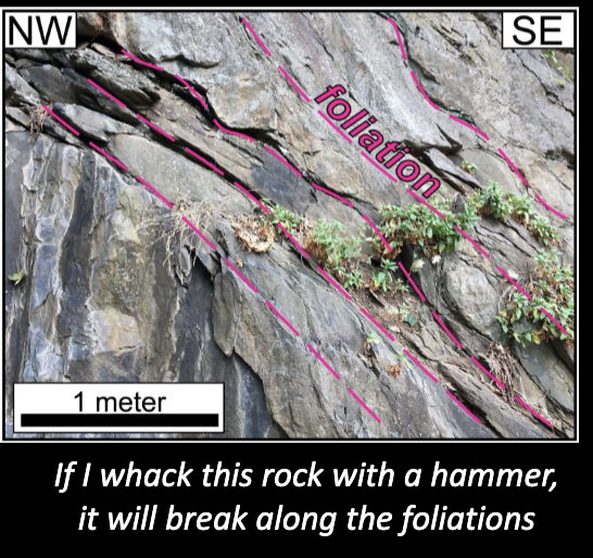
metamorphic foliation
Foliation
aligned minerals that fracture along lines (pgs of a book)
Clay materials
incorporate water into their strucutres (expand when wet, contract when dry)
Can be slipery
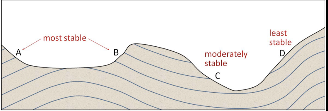
Failure surfaces
when weak surfaces are parallel to the slope, theres an issue
blue lines are bedding planes, foliation, joints/fractures, weak materials
Impact of water on slope stability
Saturated slopes reduce cohesion and add weight, making slopes more unstable
water adds weight
reduces friction b2wn surfaces
infiltrates soil/sediment and increases pore pressures to promote movement
MORE WATER = HIGHER LOAD = HIGHER STRESS
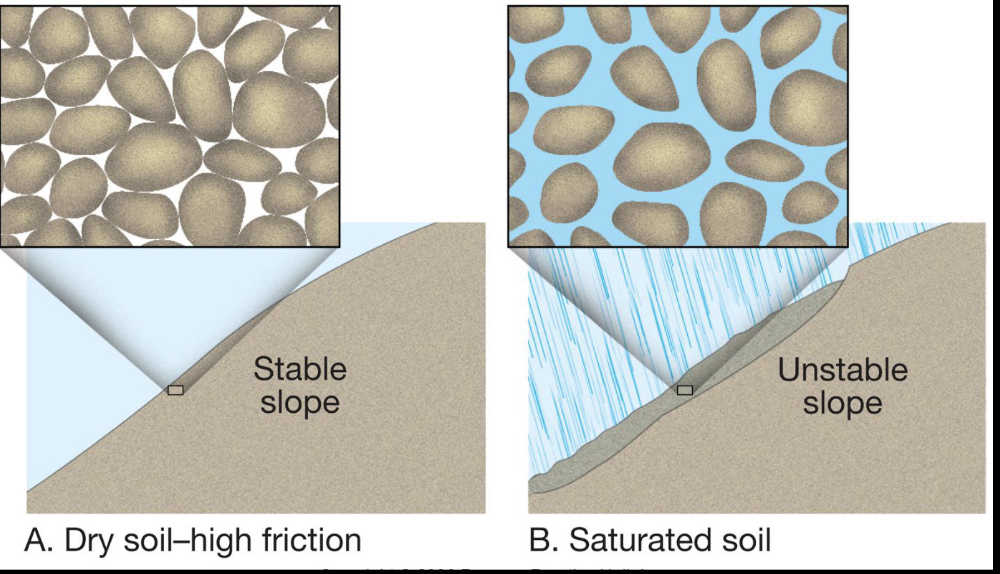
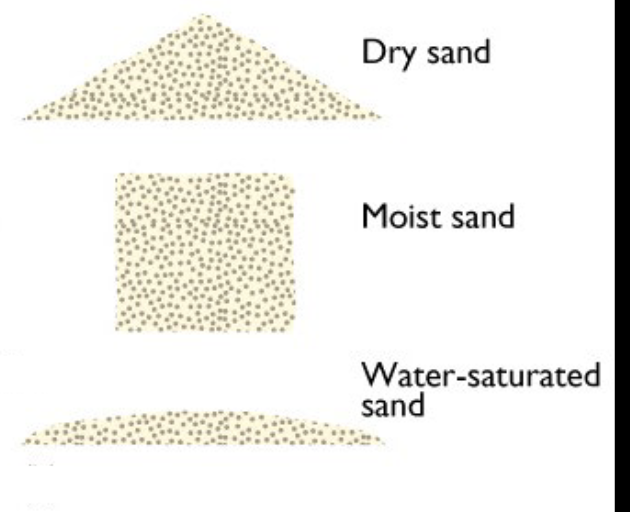
Affects of water (angle of repose)
adding water may increase angle of repose (the steepest angle of descent or dip relative to the horizontal plane to which a material can be piled without slumping) increases resisting forces
electrostatic forces
surface tension
Grains support themsleves, water reduces friction, making them flow
Frost wedging
expansion of ice in racks forces rocks apart
decreases cohesion and weakens rocks
Effects of vegetation on mass wasting
Plant roots provide a strong interlockign network to hold unconsolidated rocks and sediements
vegetation removes moisture from the soil & may incrase shear strength
Classification of mass wasting
1) Rate of movement
o Slow < 1 cm/year
o Fast > 100 km/hour
2) Type of material
o Start as solid bedrock
o Start as loose debris
3) Type of movement
o Flowing
o Sliding
o Falling
Types of mass wasting
Creep – slow, most active at the surface
• Falls – material free falls upon failure or undercutting, motion is rapid (Rockfalls are the most common form)
• Slumps – material moves downslope accompanied by rotation
• Slides – material moves as cohesive unit along a clearly defined surface
• Flows – material moves chaotically and in a disorganized fashion along definite surface
• Avalanches or debris flow – involve a wide range of material: trees,
soil, and rock
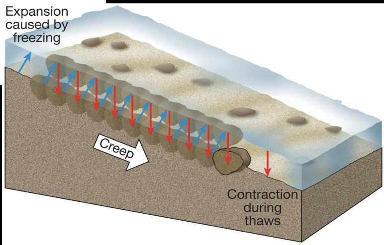
Creep
Very slow movement of soil or regolith
Major contributing factors:
• water in soil
• daily freeze-thaw cycles
Creep occurs by Soil Expansion During Freezing followed by
settling after the thaw.
Also in Expanding/Contracting Clays
Rockfall
Where bedrock breaks loose, and free falls or bounces down a cliff
– often rock fragments (talus) accumulate at cliff base
– Debris fall - free falling rock fragments, trees, houses, soil, etc
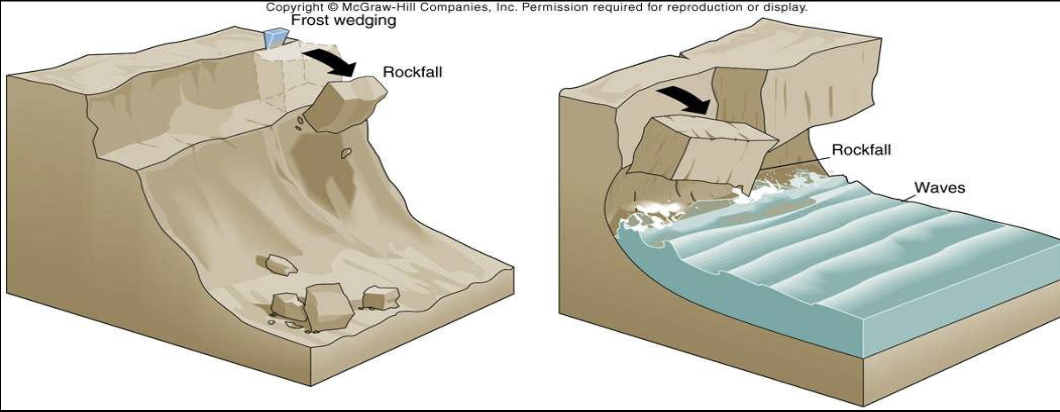
Talus
Piles of rubble left at the base of steep slopes
Often large and angular/blocky
Landslides
Rock Slide
• bedrock breaks loose, slides along
inclined surface (no free fall)
– Rock avalanche
• very rapidly moving
• broken-up bedrock, but mass
moves together
– Debris slide
• Very rapidly moving
• coherent debris mass, moves along
a defined surfaces
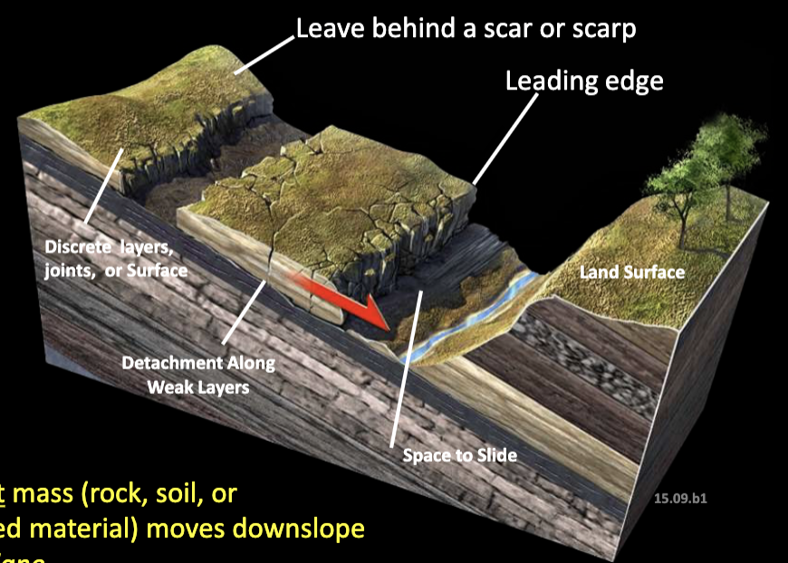
Geometry of a translational rock slide
A single intact mass (rock, soil, or
unconsolidated material) moves downslope
along a slip plane
Gros Ventre Slide 1923
Gros Ventre River Cut Through Dipping Beds
on Sheep Mountain
• Multiple Rain Events “Lubricated” Shale Slip
Plane
• 40 million cubic meters slid 1600 km and
created Slumgullion Lake
Slip planes are planes of weakness… like clay or shale bed
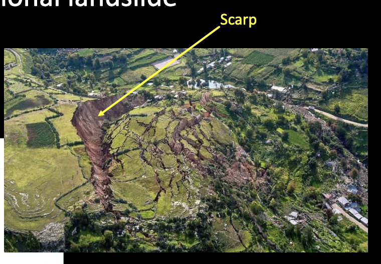
Rotational landslide
Material fails (en masse) along a rotational axis)
Often occurs in wet, mostly heterogenous materials (no bedding or “weak” layers)
Types of mass movements
• A flow is the downslope movement of unconsolidated materials, usually saturated with water.
• Unlike Slides, where particles move en masse, particles within flows move with respect to each other
Flows vs slides
Flows Churn and change (different speed rates)
Slides are tactical masses
Flows
behave like viscous liquid (resistance relative to water
May be dry or wet
move rapidly, especially when wet
carry clay to houses
mixing may occur during movement
Earthflow
- Slow movement limits loss of live but can cause substantial property
damage
dry masses of clay or silt regolith
high viscosity, move slow
Mudflow
composed of wet mix of mud & water
move fast
develop after heavy rains (cloudbursts) in semi-arid regions, where sparse vegetation have masses of loose regolith
Lahar
mudflow produced on slope of volcano
volcanic ash and hot gases melt accumulated snow and glacial ice, producing lrg quantities of mud
Debris flow
50% of material is sand-sized or larger
o Similar to mudflows, but particles are larger than sand-sized (often contain
boulders of a meter or more)
o Because of the larger particles size, they require steep slopes
o Grain to grain contact – “floats” larger particles and pushes boulders
Favelas (Brazil)
Annual Landslides and Debris Flows
Combination of
• intense summer rainstorms (> 10 in/24h)
• saturated, soil-mantled steep slopes
• uncontrolled occupation of slopes and stream-side valley bottoms
Deadly and damaging favelas occurred in January 2011 and February 2022. in brazil
Debris Avalanche
entire thickness of soil/regolith decomes detaches and rushes down slope
fast
occurs on very steep, unvegetated slops
often follow fires which kill vegetation, triggered by heavy rains, usually in winter following the fire
often becomes debris flows downslope
Field ID and Geologic Mapping
Identitfy past failures (scarps, debris flow)
Identify current slope instability (cracked ground, vegetation change, infrastructure)
Impact of human activities and prevention of landslipes
vegetation tends to stabilize slopes
• Leave as much rooted vegetation as possible on unstable slopes
• Re-plant areas affected by wildfire or construction immediately
– Avoid oversteepening of slopes during construction
• Increases shear stress and mass wasting hazards
• Place supporting material at lower end of potential failure (not on top)
• Reduce the load on the slope (remove material high on the slope)
– Avoid over-watering scenarios
• Leaking pools and water pipes, excess watering of landscape (irrigation), or
installing a poorly placed septic tank drain fields
– Plan to build away from slopes with mass wasting potential
Engineering to avoid mass wasting
Structures can be built to improve slope stability or increase material strength.
(Increases overall hillslope strength)
• Retaining Walls – Barriers that pin the face of the slope and trap rock
• Covers-A fence or coating that drapes over the slope/outcrop
Rock staples/bolt
Rods to increase rock strength
Regrading
Remove material likely or prone to failures and reinforce toe slopes
Often Requires Heavy Equipment or Controlled Blasting
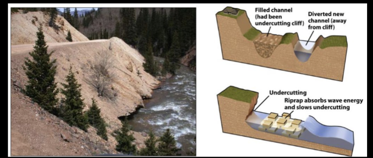
Reducing toe erosion
eliminating undercut of rock/soil and stop formation of oversteepened slope
Dewatering
Limit saturated conditions via diversion, drainage, or control
Reduce pore pressure and water weight
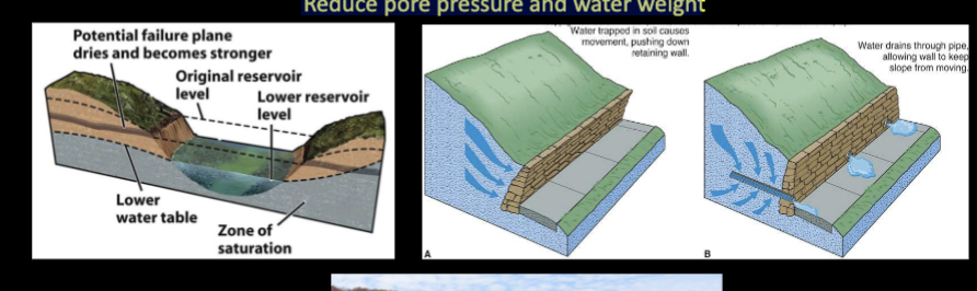
Preventative measures for mass wasting
Control Development based on Science, Safety, and Equity
• Create Well-Designed Evacuation and Emergency Plans
• Develop Slope-Monitoring Programs
• Educate the public.
Meteroid
relatively small object that moves through space; they range in size from dust
to 1 meter in size
o Composed of rock, metal, or ice
Meteorite
a meteor that hits Earth’s surfaceM