Geography 2
1/63
There's no tags or description
Looks like no tags are added yet.
Name | Mastery | Learn | Test | Matching | Spaced | Call with Kai |
|---|
No analytics yet
Send a link to your students to track their progress
64 Terms
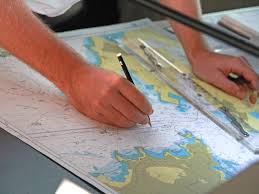
Cartographer
Person who draws and sells maps.
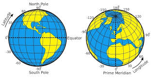
Coordinates
a system that uses a earth to determine location, Locations can be found using latitude and longitude also.
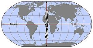
Geographic grid
the lines of latitude and longitude creating a grid
Hemisphere
Half of the earth that divides it into the western, northern, southern and eastern hemisphere

Lines of latitude
Also called parallels, lines that never touch each other running North and south of the equator
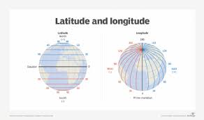
Lines of longitude
Also called meridians, Lines connect at the North and south poles running east and west of the prime meridian
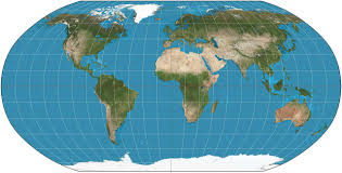
projection
Also called a map, Taking something curved and putting it on a flat surface
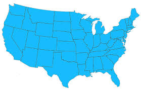
contiguous
Sharing a common border/ touching.
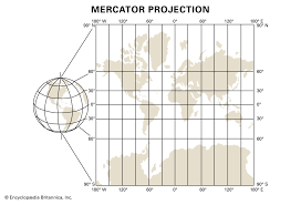
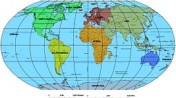
Mercator projection map
cylinder shaped map. Shows land and water distorted but direction is accurate.
Robinson projection map
A map that is round put on a flat surface and gets distorted near the north and south poles but is accurate near the equator.
Arctic circle
One of the two polar circles and the most northerly of the five major circles of latitude
Arctic region
The area within the Arctic Circle, a line of latitude about 66.5° north of the Equator
equidistant projection
shows land & water in relation to central point
polar projection
type of equidistant projection that includes one of the poles at its center
Central america
Connecting north and south America
Dependecy
greater Antilles
grouping of the larger islands in the Caribbean Sea
lesser Antilles
a group of smaller islands in the Caribbean Sea, located southeast of the Greater Antilles.
political map
west indies
a region in the Caribbean consisting of many islands, including the Greater and Lesser Antilles.
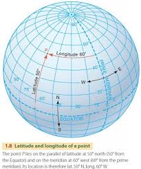
Absolute location
description of a place using grid coordinates (latitude and longitude)
coordinates
the latitude and longitude address of a place on a map
Eurasia
a landmass made up of the continents of Asia and Europe
mental map
a map that a person pictures in his or her mind
Relative location
description of a place using the relation of one place to another
sea
a body of salt water that is part of an ocean, yet is partially enclosed by land
map sketch
a rough drawing of a mental map
bar scale
a graphical representation on a map that shows the relationship between distance on the map and actual distance on the ground.
highway interchange
a junction where two or more highways meet and allow for vehicles to change from one road to another without stopping.
interstate highway
a major highway that crosses state lines and is part of the Interstate Highway System in the United States, designed for high-speed vehicular traffic.
mileage
the measure of distance traveled, typically expressed in miles, often used to indicate the distance between locations or the efficiency of a vehicle.
road map
a visual representation of roads and highways in a specific area, used for navigation and planning travel routes.
U.S. Highway
a network of roads that connect towns and cities across the United States, designated by the federal government for national travel.
archipelago
a group of islands.
basin
a depression, or dip, in the Earth's surface
cape
a high point of land that extends into a river, lake, or ocean
elevation
distance above sea level
mountain range
a series of mountains or hills arranged in a line and connected by high ground.
passage
a narrow channel of water that connects two larger bodies of water
physical map
a type of map that shows the physical features and sometimes elevation of a particular area or region in a two-dimensional format
strait
a narrow body of water that connects two larger bodies of water
tributary
a freshwater stream that feeds into a larger stream or river
air carrier airport
airport that serves planes of commercial (carry people) airlines.
cargo
all freight, except baggage, carried by an airplane
concourse
control tower
a tall building at an airport from which the movements of air and runway traffic are controlled.
gate
an airport terminal entryway used for boarding or leaving an airplane
terminal
a main airport building for passenger services
traffic pattern
a pattern of flight around an airport for arriving and departing aircraft
concourse
a large space or room in a public building such as a station or airport that people meet in or pass through
Canadian Shield
The Canadian Shield refers to the exposed portion of the continental crust underlying the majority of North America.
desert
a region of land that is very dry because it receives low amounts of precipitation
gulf
a deep inlet of the sea almost surrounded by land, with a narrow mouth.
isthmus
a narrow strip of land with sea on either side, forming a link between two larger areas of land.
mountain range
a series of mountains or hills arranged in a line and connected by high ground
plains
a large area of flat land with few trees.
peninsula
a piece of land almost surrounded by water or projecting out into a body of water.
bay
a broad inlet of the sea where the land curves inward.
mouth
Pacific region
the Pacific Ocean, the Pacific Islands, the Asia-Pacific region, or the Pacific Coast
Rocky Mountain region
Idaho, Montana, Wyoming, Colorado, and down to New Mexico
Southwest Region
Arizona, New mexico, Texas, and Oklahoma
North-Central region
North Dakota, South Dakota, Nebraska,Kansas, Minnesota, Iowa,Missouri, Wisconsin, Illinois, Michigan,Indiana, and Ohio
Southeast region
Alabama, Arkansas, Florida, Georgia, Kentucky, Louisiana, Mississippi, North Carolina, South Carolina, Tennessee, Puerto Rico, the United States Virgin Islands, and Virginia
Northeast region
onnecticut, Delaware, District of Columbia, Maine, Maryland, Massachusetts, New Hampshire, New Jersey, New York, pennsylvania, puerto Rico, Rhode Island, Vermont, Virgin Islands, Virginia and West Virginia.