River enviornments
1/36
There's no tags or description
Looks like no tags are added yet.
Name | Mastery | Learn | Test | Matching | Spaced |
|---|
No study sessions yet.
37 Terms
Characteristics of the Hydrological Cycle:
Closed system: No water enters or leaves the Earth; it simply circulates through different stores and transfers.
Characteristics of the Hydrological Cycle:
Stores of Water:
Oceans: Largest store (~97% of Earth's water).
Ice and snow: Stored in glaciers and polar ice caps.
Groundwater: Stored in aquifers beneath the Earth's surface.
Lakes and rivers: Surface water bodies.
Atmosphere: Water vapor and clouds.
Soil moisture: Water stored in the soil.
Characteristics of the Hydrological Cycle:
Transfers (Flows) of Water:
Evaporation
When the Sun heats up water from oceans, rivers, lakes, or puddles, the water changes from a liquid into a gas called water vapour. This is how water moves from the sea and land into the air. It's a key way that water enters the atmosphere.Transpiration
Plants take in water from the soil through their roots. They release some of this water into the air as water vapour through tiny holes in their leaves. This process is called transpiration — like the plant "breathing out" water.Evapotranspiration
This is the combined effect of evaporation (from water surfaces) and transpiration (from plants). Together, they move water from the land into the air.Condensation
When water vapour in the air cools down, it turns back into tiny water droplets. These droplets come together to form clouds. This is the opposite of evaporation.Precipitation
When the water droplets in clouds get heavy enough, they fall to the ground as rain, snow, or hail. This is how water moves from the atmosphere back to the land or sea.Overland Flow (Runoff)
Some rainwater can’t soak into the ground and flows across the surface of the land. It moves downhill because of gravity and eventually reaches a stream, river, or lake.Infiltration and Percolation
Infiltration is when water soaks into the ground from the surface.
Percolation is when that water moves deeper down through the soil and rocks into underground stores like aquifers.
Throughflow
Some water that soaks into the soil flows horizontally (sideways) through the soil layer, slowly moving towards a river or stream. This happens above the deeper groundwater store.Groundwater Flow
This is when water moves underground through rocks in aquifers. It’s a slow process and eventually leads to rivers, lakes, or the sea.
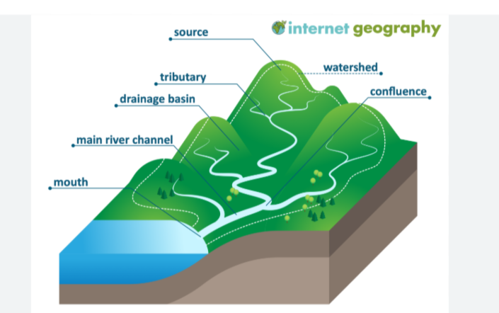
What are the main features of a drainage basin?
Source: The starting point of a river, typically in upland or mountainous areas, where water begins to flow.
Watershed: The boundary that separates one drainage basin from another, typically marked by ridges or highland areas.
Tributaries: Smaller rivers or streams that flow into a larger river.
Confluence: The point where two rivers or streams meet.
Channel network: The system of rivers and tributaries that make up the drainage basin.
Main river channel: The main watercourse that carries the river from its source to its mouth.
Mouth: The endpoint of the river where it flows into a larger body of water like a sea, ocean, or lake.
What factors affect river regimes?
Precipitation: The amount and intensity of rainfall, especially during storms, determines river flow. Storm hydrographs show how a river responds to rainfall events.
Temperature: High temperatures increase evaporation, reducing river discharge, while cold temperatures delay runoff (e.g., snowmelt).
Vegetation: Dense vegetation can slow down runoff and increase infiltration, while less vegetation leads to faster runoff.
Land use: Urbanization (e.g., concrete) increases surface runoff, leading to faster response in storm hydrographs. Agricultural land may also alter runoff patterns.
Water abstraction: Removal of water for consumption (e.g., agriculture, industry) can reduce river flow.
Dams: Dams regulate river discharge, storing water and reducing flow variability.
What fluvial processes are involved in river valley and river channel formation?
Erosion:
Vertical erosion: Downward cutting in the riverbed, typical in the upper course.
Lateral erosion: Sideways cutting of the riverbanks, typical in the middle and lower courses.
Weathering:
Mechanical weathering (freeze-thaw): Water freezes in cracks and expands, breaking rock.
Chemical weathering: Acids in rainwater dissolve rock minerals.
Biological weathering: Roots or animals break down rocks.
Mass movement:
Slumping: Movement of saturated soil along curved planes.
Rockfalls: Sudden downward fall of rock from steep slopes.
Soil creep: Slow, gradual movement of soil down a slope.
Transportation:
Traction: Larger rocks are rolled along the riverbed.
Saltation: Smaller rocks and particles bounce along the bed.
Suspension: Fine particles are carried by the water flow.
Solution: Dissolved minerals are carried in the water.
Deposition:
Occurs when the river loses energy, and sediment is dropped. Deposition is common in the lower course, where water flow slows
How do channel shape (width, depth),change along the course of a river?
Upper course: Narrow and shallow due to vertical erosion.
Middle course: Becomes wider and deeper as lateral erosion dominates.
Lower course: Widest and deepest due to larger discharge and more lateral erosion.
How do valley profile (long and cross profiles) change along the course of a river?
Long profile: Steep gradient in the upper course, flattening out downstream.
Cross profile:
Upper course: V-shaped valleys with steep sides.
Middle course: U-shaped valleys with gentler slopes.
Lower course: Very wide, flat valleys with a floodplain.
How does Gradient change along the course of a river?
Upper course: Steep gradient.
Middle course: Moderate gradient.
Lower course: Gentle gradient, often almost flat.
How does velocity along the course of a river?
upper course: Slower flow due to friction and obstacles.
Middle course: Faster due to deeper, wider channels.
Lower course: Fastest flow because of less friction and greater depth
How does Discharge: change along the course of a river?
iincreases downstream as more tributaries join the river, and water from rainfall, runoff, and groundwater adds to the river's volume
How does Sediment size and shape change along the course of a river?
Upper course: Large, angular sediments.
Middle course: Smaller, more rounded sediments due to abrasion.
Lower course: Fine particles, often suspended in water.
How do river landscapes change over the course of a river, with distinctive upland landforms?
V-shaped valleys: Formed by vertical erosion.
Interlocking spurs: Formed when the river winds around hard rock.
Waterfalls: Created where soft rock erodes faster than hard rock.
Gorges: Steep valleys left behind as waterfalls retreat upstream.
How do river landscapes change over the course of a river, with distinctive middle course landforms?
Middle Course:
Meanders: Bends in the river formed by lateral erosion on the outer bend and deposition on the inner bend.
River cliffs and slip-off slopes: Formed on opposite sides of a meander.
Wider, flatter valley.
How do river landscapes change over the course of a river, with distinctive lowland landforms?
Oxbow lakes: Created when a meander is cut off from the main river.
Floodplains: Wide, flat areas that are periodically flooded.
Levees: Natural embankments formed by sediment deposition during floods.
Deltas (in large rivers): Deposition builds land at the river mouth.
What are the reasons for variations in water quality, including pollution and the storage and supply of clean water?
Causes of Poor Water Quality:
Sewage: Untreated waste enters rivers.
Industrial Waste: Toxic chemicals from factories.
Agricultural Runoff: Fertilizers and pesticides enter rivers.
Improving Water Supply:
Dams & Reservoirs: Store water for dry periods.
Pipelines: Transport water to areas with shortages.
Treatment Plants: Purify water for human consumption.
What are the causes of river flooding,
Heavy Rainfall: Sudden, intense rainfall leads to fast runoff.
Snowmelt: Thawing snow increases water flow.
Monsoons: Seasonal heavy rainfall causes flooding in tropical areas.
Relief: Steep slopes create faster runoff.
Urbanization: Increased surface runoff due to concrete and buildings.
Deforestation: Reduces natural interception, leading to more runoff.
river flooding, and how can it be predicted
Weather forecasting: Predicts rainfall and river flow.
River monitoring: Measures water levels to warn of rising flows.
river flooding, and how can it be prevented
Hard engineering: Dams, levees, and flood barriers.
Soft engineering: Floodplain zoning, afforestation, and creating wetland areas to absorb excess water.
Sustainable management: Working with nature to prevent and reduce flooding impacts.
whats the difference between a hyrdological system and a drainage basin
drainage basin is an open system
The inputs of a drainage basin are:
• energy from the Sun • precipitation formed from moisture picked up outside the basin • possibly water from tributary drainage basins
outputs of a drainage basin
• the dyer's discharge • the water inns basin from which evaporation and transpiration take place; the water eventually falls as precipitation in another drainage basin.
Why is a Drainage Basin Open?
A drainage basin, on the other hand, is considered an open system because it receives water from the outside and loses water to other areas.
Water enters the drainage basin mainly through precipitation (rain, snow, etc.).
Water leaves the drainage basin through evaporation (into the atmosphere) and discharge (water flowing into rivers, lakes, or the sea).
External inputs and outputs make it an open system, as water isn't trapped within the basin — it flows in and out.
Why is the Hydrological Cycle Closed?
The hydrological cycle is considered a closed system because water is recycled within the Earth's system, with no net loss or gain of water.
river regeime
the pattern of flow or the variation in a river's discharge (amount of water flowing through the river) over a period of time, typically throughout the year.
Why is it important to study how rivers behave after heavy rainfall, and how does a storm hydrograph help?
Many of the world’s drainage basins are densely populated because of their fertile soil and suitability for farming, along with the development of homes, businesses, and transport in these areas.
Knowing how rivers respond to heavy rainfall is essential to predict and manage flooding. A storm hydrograph is a useful tool that shows how a river’s discharge changes over time after a storm, helping people assess flood risks and plan accordingly.
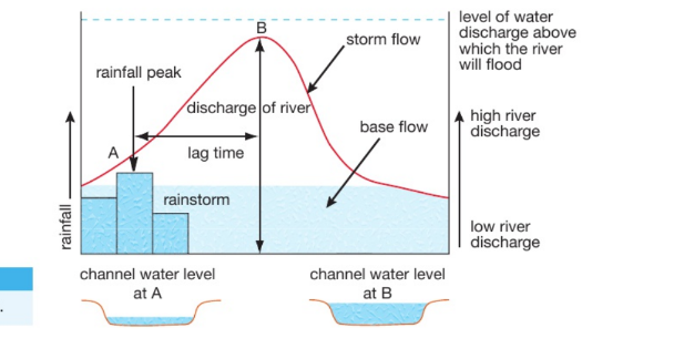
What does a storm hydrograph show, and why is lag time important in flood prediction?
A storm hydrograph shows how a river’s discharge (flow) changes after a rainstorm. The bars on the graph represent how much rain fell. There's a delay between the peak rainfall and the peak river discharge — this delay is called the lag time.
A short lag time means water reaches the river quickly, causing a steep rise in discharge and a higher risk of flooding.
The hydrograph can also show the flood threshold — the discharge level above which flooding occurs.
After the peak discharge, the river’s water level begins to fall as the storm passes.


Six main factors influence how quickly water reaches a river and how the river responds after rainfall:
Rain Amount & Intensity: Heavy rain can't soak into the ground fast enough, so it flows over the surface (runoff) and quickly enters the river.
Temperature: Cold temperatures cause snow instead of rain. Snow takes longer to melt, but when it does, especially over frozen ground, the water can rush into the river fast.
Slope: Steep slopes cause faster runoff. Flat land lets more water soak in, slowing its journey to the river.
Rock Type:
Impermeable rocks (like clay) stop water from soaking in — faster runoff.
Permeable rocks (like chalk) allow water to soak in — slower runoff.
Vegetation & Land Use:
Trees/plants slow down rainwater by catching it.
Urban areas (roads, concrete) speed up runoff, increasing flood risk.
Human Activities:
Dams and reservoirs can control river flow and reduce flooding.
Water abstraction (taking water from rivers) affects how much water is in the river overall.
What are the main uses of water?
Water is used in many different ways:
Agriculture – to irrigate crops and help plants grow.
Industry – used for cooling machines, making products, and processing materials.
Domestic use – for drinking, cooking, washing, and other everyday home needs.
Leisure – for activities like swimming, boating, and other fun uses.
Why is the demand for water increasing?
The need for water is growing because:
The world population is increasing, meaning more people need water.
Cities are getting bigger (urbanization), which raises demand for homes and water.
Industries and large farms need more water for production.
People are living with higher standards and using more water at home (e.g., showers, washing machines, gardens
What is a water surplus and where does it happen?
A water surplus is when an area has more water than it needs. This happens in places that:
Have lots of rainfall.
Have a low population, so less demand for water.
Examples: Canada and Norway – both have plenty of fresh water.
What is a water shortage and where does it happen?
A water shortage happens when there is not enough water to meet people's needs. This occurs in places that:
Are hot and dry, with little rain.
Have high water use or polluted water sources.
Examples: North Africa and the Middle East often suffer from water shortages.
whats infiliration
Infiltration
Definition: Water soaks into the ground from the surface.
Where: At the soil surface.
Movement: Downward into the soil.
Memory Tip: "I = Infiltration = Initial soaking."
Percolation
Definition: Water moves deeper down through the soil and rock layers.
Where: Below the topsoil, into deeper layers and aquifers.
Movement: Further downward.
Memory Tip: "P = Percolation = Penetrating deeper underground."
Throughflow
Definition: Water moves sideways through the upper soil layer.
Where: Within the soil (above the water table).
Movement: Horizontal (sideways), toward rivers/streams.
Memory Tip: "T = Throughflow = Travels sideways through soil."
Groundwater Flow
Definition: Water moves slowly through rock layers deep underground (aquifers).
Where: In saturated rock layers beneath the soil.
Movement: Very slow, eventually reaching rivers, lakes, or seas.
Memory Tip: "G = Groundwater = Goes slowly through ground rock."