Coastal Zone Processes and Features: Beaches, Waves, and Erosion
1/81
There's no tags or description
Looks like no tags are added yet.
Name | Mastery | Learn | Test | Matching | Spaced | Call with Kai | Chat |
|---|
No analytics yet
Send a link to your students to track their progress
82 Terms
What does the coastal zone include?
The coastal zone includes the beach, nearshore zone, and extends into the hinterland.
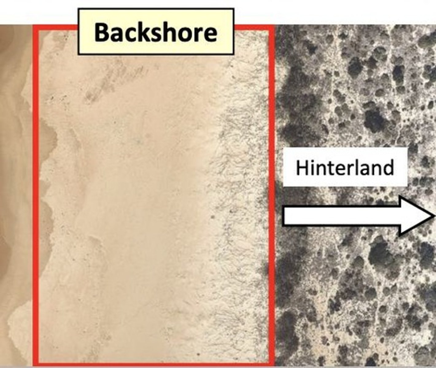
What is the backshore?
The backshore is dry under normal conditions, located above the high tide limit, and includes beaches and berms.
What is the foreshore?
The foreshore is the area between the high and low tide limits, from the top of the berm to the water line.
What is the nearshore zone?
The nearshore zone is underwater and subject to shallow water processes, stretching from the swash zone to deep water.
What is the offshore zone?
The offshore zone is the deep water outside of the closure depth where sediment is stirred up on the sea floor.
What is the active coastal zone?
The active coastal zone is where sand is exchanged in a cross-shore direction, perpendicular to the shoreline.
What is closure depth?
Closure depth is the seaward limit of nearshore-offshore sediment exchange, which can change based on wave size.
What is a beach profile?
A beach profile quantifies beach slope, morphology, and volumetric changes, allowing measurement of changes pre- and post-storm.
What is the swash zone?
The swash zone is the land-ocean boundary where waves run up and down the beach.
What is the difference between swash and backwash?
Swash is the onshore flow of water, while backwash is the return flow of water back to the ocean.
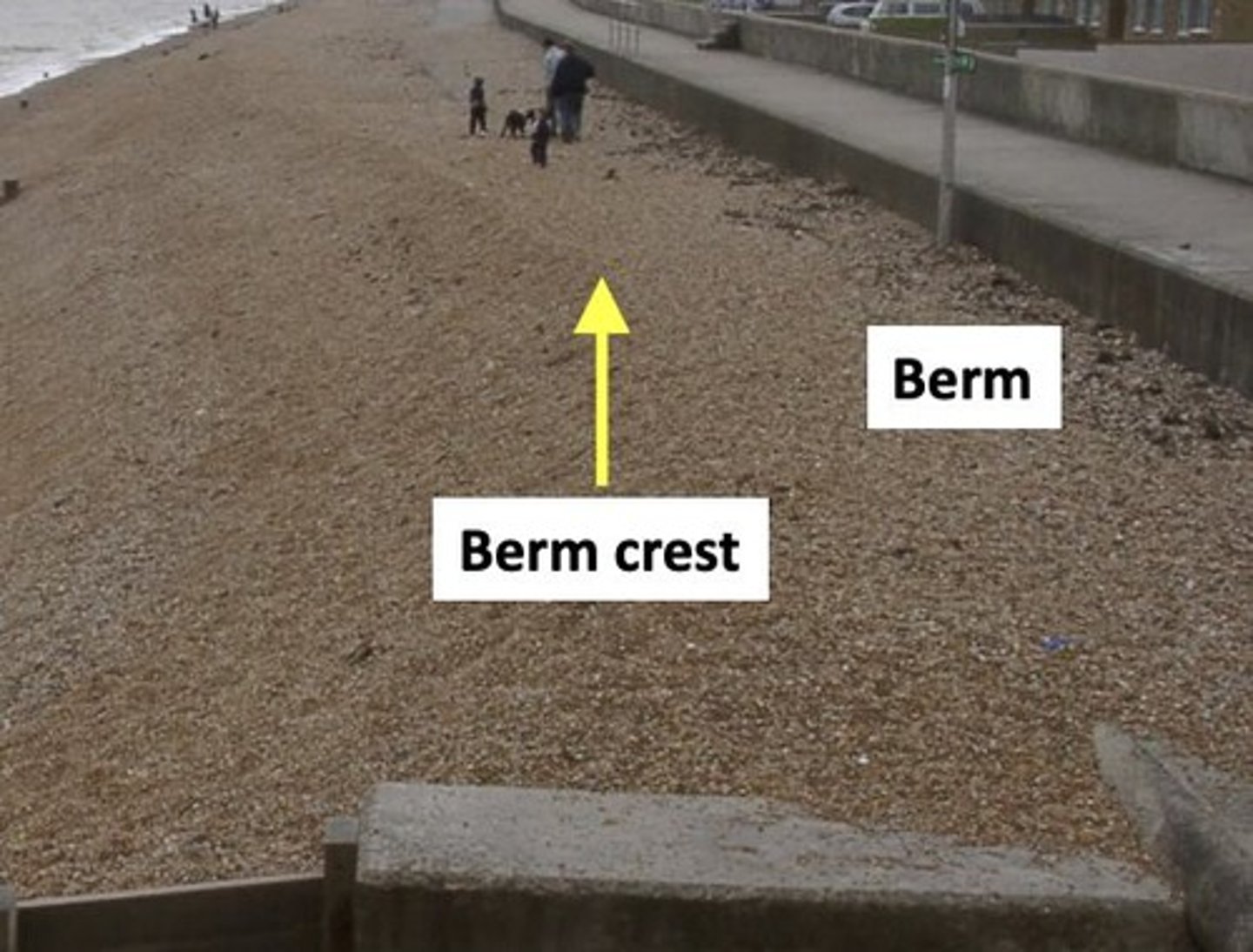
What is a beach berm?
A beach berm is a near-horizontal plateau on the beach face formed by the deposition of material by waves.
What is morphodynamics?
Morphodynamics is the interaction between hydrodynamics and the sediment response to it.
What generates coastal wind waves?
Coastal wind waves are generated by pressure differences across the ocean's surface and wind acting on the ocean.
What factors affect wave height?
Wave height is affected by wind speed, wind duration, and fetch distance.
What is fetch?
Fetch is the distance of water wind can move over in a constant direction to generate waves.
What is significant wave height (Hs)?
Significant wave height (Hs) is the average measurement of the largest one-third of waves.
What is wave shoaling?
Wave shoaling is the change in shape and behavior of waves as they propagate into shallower water.
What happens to waves in shallow water?
In shallow water, waves decrease in celerity and wavelength, and increase in height and steepness.
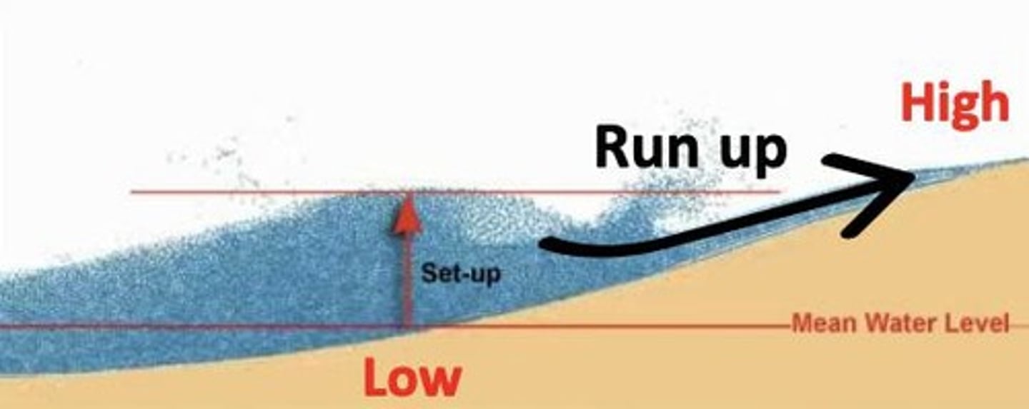
What is the setup of waves?
Setup refers to how high waves stack up against the shore.
What is runup?
Runup is how high or far waves reach on the shoreline.
What are constructive waves?
Constructive waves build beaches, with swash stronger than backwash, moving more sediment up the berm.
What are destructive waves?
Destructive waves erode beaches, with backwash stronger than swash, transporting sediment offshore.
What characterizes summer beach profile conditions?
In summer, beach profile conditions feature low wave height, with sediment moving onshore and a wide, flat beach.
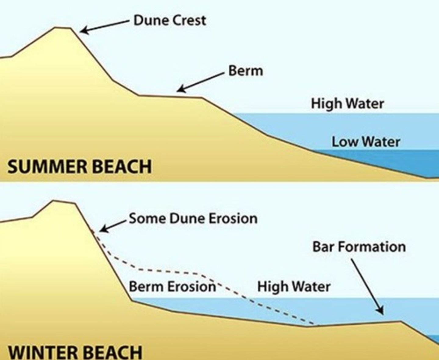
What occurs during storm conditions on the beach?
During storm conditions, there are big steep waves, resulting in a narrow and eroded beach.
What is the relationship between wave size and wavelength?
Generally, the bigger the wave, the bigger the wavelength.
What is the maximum wave height (Hmax)?
Maximum wave height (Hmax) is the single highest wave in a wave record.
What is wave period?
Wave period is the time for a full waveform (crest to crest) to pass a fixed position.
What is wave celerity?
Wave celerity is the velocity of the waveform, measured in meters per second (m/s).
What are the typical conditions of a winter beach profile?
Higher waves, steep waves, narrow and steep beach, with some dune and berm erosion.
What occurs during long-term net erosion?
Sediment does not move back onshore after being eroded.
What factors control erosion severity?
Wave height and period, sea level and tidal stage, lithology and sediment type, beach width/dune height, vegetation, frequency/magnitude of events, and human impact.
What is the impact of human structures like seawalls on coastal erosion?
They can reflect wave energy back, leading to erosion of the beach in front of them.
Describe the wave climate affecting Narrabeen Beach.
It is generally from the southeast, impacted by ex-tropical cyclones and East Coast Lows.
What was the anomalous event at Narrabeen Beach in 2016?
An easterly wave direction was 45° more counterclockwise than average, generating an extreme rip current that led to intense offshore erosion.
What is 'set-up' in coastal processes?
It is when waves stack on top of each other, temporarily increasing water level against the shoreline.
What is the difference between run-up and return flow?
Run-up is how far a wave runs up the beach, while return flow is the reverse movement of water back to the sea.
What are rip currents?
Strong offshore currents caused by seaward return flow concentrated in narrow zones along the beach.
What are the components of a rip current's anatomy?
Feeders, neck, and head.
What conditions favor the formation of rip currents?
Wave dominance and complex bathymetry in the nearshore.
What is longshore drift?
The movement of sediment along the shore due to waves approaching at an oblique angle.
What is the CERC formula used for?
Estimating total longshore sediment transport rate based on longshore energy flux.
What is a tombolo?
A spit that connects to a hard rocky outcrop, formed when drift acts on both sides.
What is the significance of the Farewell Spit in New Zealand?
It is the longest sandspit in NZ, formed from quartz sand transported via longshore drift.
What was the outcome of the sand bypass system at Tweed Heads?
It bypassed more than 8 million m³ of sand across the Tweed River entrance from 2001-2015.
What causes waves?
Vertical displacement of water due to winds, extreme events like tsunamis, or ultra low-frequency processes like tides.
What is the difference between semi-diurnal and diurnal tides?
Semi-diurnal tides have two low and high tides daily of similar size, while diurnal tides have one of each.
What is the role of vegetation in coastal areas?
It helps stabilize dunes and attenuates wave energy, reducing erosion.
What is a rip pulse?
A sudden acceleration in flow speed associated with the breaking of incoming wave groups.
What is cross-shore transport?
Sediment transport that occurs perpendicular to the shore, common on small embayed beaches.
What is the impact of storm clustering on beach erosion?
It leads to more severe erosion as there is insufficient time for the beach to recover.
What are shadow rips?
Eddies that form on the opposite side of hard engineering structures like seawalls.
What is the average cost of the seawall built at Narrabeen Beach?
$282,000 per person.
What is the typical speed of longshore currents?
Typically between 0.2 to 1 m/s.
What is the significance of the 2020 storms in the context of coastal erosion?
They exemplified a shift towards more frequent storms at higher magnitudes, exacerbating erosion.
What is the effect of bathymetry on wave setup?
It creates localized variations in wave setup, influencing the formation of rip currents.
What is the most common tidal pattern in New Zealand?
Semi-diurnal tides.
What is a mixed semi-diurnal tide?
Two low and high tides daily but of different sizes.
What is a diurnal tide?
One low and one high tide every day of a similar size.
What happens to currents when tides are rising or falling?
Currents develop and flow faster through small passages.
Where are the fastest tidal flows in New Zealand found?
French Pass in the Marlborough Sounds, with currents flowing at 4 m/s.
What is the largest tidal range in the world?
The Bay of Fundy, with a tidal range of 16 meters.
What characterizes tide-dominated systems?
Low wave energy, fine sediments, and wide funnel-shaped estuaries.
What are the key characteristics of mixed energy systems?
Moderate energies and tidal ranges of 2-4 m.
What defines wave-dominated systems?
High wave energy, well-sorted sand and gravel, and steep beaches.
What are reflective beaches?
Beaches with the lowest energy, coarsest sediments, and steep beach faces.
What is an example of an intermediate beach?
Pauanui beach.
What characterizes dissipative beaches?
Highest energy, finest sediment, and wide surf zones.
What are tide-dominated beaches like?
Low-energy beaches with wide sand or mud flats and no visible waves breaking.
What are beach cusps?
Shoreline formations made up of various grades of sediment in an arc pattern.
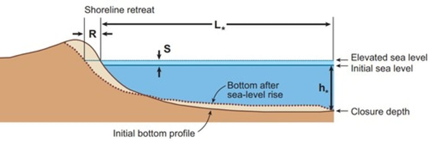
What is the Bruun Rule?
A simple equilibrium model predicting shoreline recession due to sea level rise.
What are the limitations of the Bruun Rule?
It assumes a uniform sandy beach and omits important variables like geological controls.
What is the significance of sediment composition in beach classification?
It influences beach morphology and response to waves.
What are pure sand beaches characterized by?
Dunes, berms, and bars with easy sediment movement.
What defines pure gravel beaches?
Composed of pure gravels, steep gradients, and well-preserved storm berms.
What are mixed sand-gravel (MSG) beaches?
Beaches with a bimodality of coarse/fine sediments showing preferential sorting.
What is a composite beach?
Beaches with both sand and gravel, having distinct flat and steep areas.
What are coral beaches and how do they form?
Beaches adjacent to reefs formed from broken coral during storms.
What is the role of waves in shaping beach morphology?
Waves influence the sediment type and beach profile.
What is the fall velocity (ws) in relation to beach sediment?
It is the speed at which the median grain size would fall through water.
What is the effect of sea level rise on sandy beaches?
It can lead to shoreline recession, predicted by models like the Bruun Rule.
What is the typical tidal range for macrotidal systems?
Greater than 4 m.
What are the characteristics of mangroves in tide-dominated systems?
They are found in sheltered settings with no waves breaking.