ecology block 1
 Call Kai
 Learn
Learn Practice Test
 Spaced Repetition
 Match
Match Flashcards
 Knowt Play
1/36

There's no tags or description
Looks like no tags are added yet.
Name | Mastery | Learn | Test | Matching | Spaced | Call with Kai | Chat |
|---|
No analytics yet
Send a link to your students to track their progress
37 Terms
weather
- Describes current conditions
- Irregular & largely unpredictable.
climate
- Describes long-term patterns
- Based on averages and variation measured over decades.
Spatial climate patterns depend on:
1. Unequal heating with latitude and season
2. Air circulation and Coriolis effect
3. Ocean currents
4. Miscellaneous other impacts of land and water
Greenhouse effect
Greenhouse effect: the process of solar radiation striking Earth, being converted to infrared radiation, and being absorbed and re-emitted by atmospheric gases.
Near the equation (low latitudes) solar rays:
o Strike at 90° angle, energy spread over a smaller area
o Travel a shorter distance, lose less energy.
Near the poles (high latitudes) solar rays:
o Strike at wider angle, same energy spread over a larger area
o Travel further, lose more energy.
Seasonal variation is caused by
the tilt of the Earth on its axis (23.5°)
Solar equator:
- latitude receiving the most direct rays of the Sun
o March equinox = geographic equator (0° latitude)
o June solstice = Tropic of Cancer, 23.5° N
o September equinox = geographic equator (0° latitude.)
o December = Tropic of Capricorn, 23.5° S
Properties of air:
o Warm air is less denes à rises!
o as air rises and expands, it cools (adiabatic cooling) and holds less water vapor.
o Cold air is denser à sinks
o as air sinks and condenses, it warms again (adiabatic heating) and holds more water vapor.
These properties create convection cells. Hadley cells are near the equator.
polar cells
- between 60-90° latitudes. Easterlies: winds move NE to SW in northern hemisphere and SE to NW in the southern hemisphere.
ferrel cells
- less distinct, between Hadley and Polar cells.
hadley cells
between equator and 30°N and 30°S latitudes
Intertropical Convergence Zones (ITCZ):
where the Hadley cells meets
o Determined by solar equator.
Convection cells create:
- Wet and dry regions
o Wet tropics
o Dry sub-tropics (around 30° N & S)
- Wet and dry seasons
o One wet season near 23.5° N & S (tropics of Cancer and Capricorn)
Coriolis effect
- Wind direction is affected by the speed of the Earth’s rotation.
- This deflects air circulation in the convection cells
o to the right in the North
o to the left in the South.
Northeast trade winds:
air on surface in northern Hadley cell moves from NE to SW
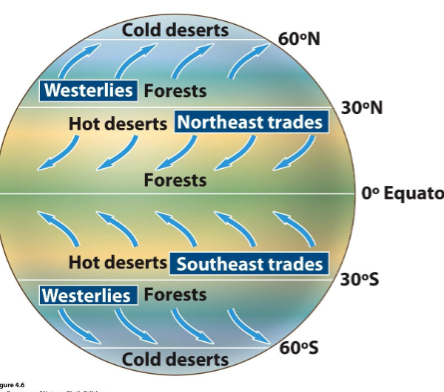
Southeast trade winds
move from SE to NW

Westerlies
general mid-latitude movement from West to East.
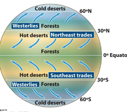
Polar Easterlies
movement away from the poles and from East to West associated with the Polar cells (like the trade winds).

gyres
o Gravity pulls warmer higher water away from the equator.
o Clockwise circulation in N, counter-clockwise in S due to trade winds and westerlies.
upwelling
o Upward movement of ocean water
o Where surface currents move away from western coastlines.
El Nino / Southern Oscillation (ENSO)
- No cold water upwelling à warm water = poor fishing harvest (December)
- Lots of rain in a coastal desert area.
- Trade winds usually cause upwelling near Peru.
- Every 3-7 years, trade winds reverse (oscillate).
- Warm water moves in the opposite direction
Rain Shadow effects
- Wet warm air moves upward over mountains, cools and loses moisture (precipitation) on windward side. As this air descends on the leeward side it warms, absorbs moisture and dries the land.
biome
a geographic region that contains communities composed of organisms with similar adaptations. Determined by:
- Climate
- Soil
- Fire
- Grazing
Convergent evolution:
- Unrelated species look similar due to evolving under similar conditions.
- This leads to biomes.
tundra
Biome <5°C. the coldest biome; characterized by a treeless expanse above permanently frozen soil.
boreal forests
Biome <5°C. a biome densely populated by evergreen needle-leaved trees, with a short growing season and severe winters. Also known as taiga.
temperate rainforests
Biome 5°C-20°C. biome known for mild temperatures and abundant precipitation; dominated by evergreen forests.
temperate seasonal forests
Biome 5°C-20°C. biome with moderate temperature and precipitation conditions, dominated by deciduous trees. This is where we live.
shrubland
Biome 5°C-20°C. a biome characterized by hot, dry summers and mild, wet winters, a combination that favors the growth of drought-tolerant grasses and shrubs.
temperate grasslands / cold deserts
Biome 5°C-20°C. biome characterized by hot, dry summers and cold, harsh winters; dominated by grasses, nonwoody flowery plants, and drought-adapted shrubs.
tropical rainforests
Biome > 20°C. warm + rainy biome characterized by multiple layers of lush vegetation, found near the equator (ITCZ).
tropical seasonal forests / savannas
Biome > 20°C. warm temperatures and distinct wet, dry seasons; dominated by deciduous trees that shed their leaves during dry season
Subtropical desert
Biome > 20°C. characterized by hot temperatures, scarce rainfall, long growing seasons, and sparse vegetation.
role of soil
- Chemically and biologically active
- Determining factors:
o Climate
o Organisms, vegetation feedback
o Local topography
o Parent material
o Age
- Drives plant species distribution and primary productivity.
layers of soil
- (leaching moves soluble inorganic nutrients to lower layers)
- Only An Educated Boy Can Read
o O (decaying organic matter, abundant microorganisms)
o A (broken down organic material and finely broken up rock)
o E (leached inorganic material)
o B (weathered rock, rich in inorganic nutrients)
o C (less weathered, large rocks of parent material)
o R (bedrock, unweathered parent)
Tropical rainforest soils are nutrient poor
- Old soils
- Wet conditions cause high rates of weathering and leaching
- Minerals from bedrock are too deep to access.
- High productivity in rainforest depends on rapid cycling of nutrients close to surface.