Heli Shit
 Call Kai
 Learn
Learn Practice Test
 Spaced Repetition
 Match
Match Flashcards
 Knowt Play
1/79

There's no tags or description
Looks like no tags are added yet.
Name | Mastery | Learn | Test | Matching | Spaced | Call with Kai | Chat |
|---|
No analytics yet
Send a link to your students to track their progress
80 Terms
What is convective Turbulence, where are the updrafts more intense and what marks the top of these updrafts?
Convective Turbulence is the vertical movement of air caused by heating. Instability arises when air at lower levels is heated and becomes less dense than surrounding air and rises. Subsidence then occurs around the rising air. This creates eddies in between the rising and falling pockets of air. These updrafts are more intense over bare ground, rocky and paved areas. These updrafts are marked by fair weather cumulus clouds
What is a squall?
A sudden, sharp increase in wind speed that lasts for several minutes
What are the 3 factors that determine the nature of weather found at a cold front and how?
Moisture content of warm air mass: determines amount of cloud and precipitation
Stability of warm air mass: determines if cumulus type or layered type clouds will form
Speed of advancing cold air mass: also a factor in determining type of cloud that forms but also severity of weather
What does AMP stand for?
Arctic, Maritime and Polar. Coldest to warmest types of fronts
what are the 3 processes of cooling that are present in the troposphere?
Advection over a cool surface, conduction over a surface that has undergone radiational cooling and expansional cooling
What 4 air masses affect Canada
Continent Arctic (cA), Maritime Arctic (mA), Maritime Polar (mP) and Maritime Tropical (mT)
Up to how many air masses can exist across the world, how are they categorised and what are they called?
Up to 6 air masses can exist across the world that are categorised by temperature and subcategorised by moisture content. Cold air masses are called Arctic, moderate air masses are called Polar and warm air masses are called Tropical. There are 2 subcategories of each with moist air masses called maritime and dry being called continental. Etc. mP or mA
What are the 2 ways for air to become saturated?
By adding moisture to the atmosphere or cooling the air which slows the rate of detachment
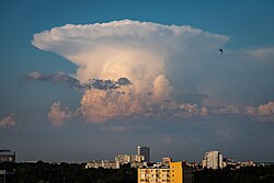
Name this cloud, it’s abbreviation and explain its unique features along with weather patterns associated with this cloud.
Cumulonimbus Clouds (CB) can span across all three bands with the tops even extending into the tropopause. They indicate a very unstable air mass with severe turbulence, rain and potentially lightning and hail. The tops of CBs may spread out to form an anvil shape if higher winds are present at tropopause altitudes

Name this cloud, it’s abbreviation and explain its unique features along with weather patterns associated with this cloud.
Towering Cumulus Clouds (TCU) can span across the lower to mid level bands. They start as cumulus clouds however due to an unstable air mass they develop vertically. Turbulence can range from light to severe with the potential of up to heavy rainfall

Name this cloud, it’s abbreviation and explain its unique features along with weather patterns associated with this cloud.
Cumulus Clouds (CU) found below 6,500ft ASL. Puffy white cotton ball like structures. They indicate an unstable air mass that can include light to possibly moderate turbulence
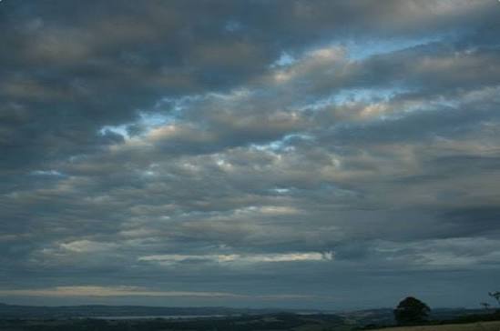
Name this cloud, it’s abbreviation and explain its unique features along with weather patterns associated with this cloud.
Stratocumulus Clouds (SC) found below 6,500ft ASL. They are described as cumulus clouds that have arranged into rows or banks. Some mild precipitation is possible with mild to possible moderate turbulence

Name this cloud, it’s abbreviation and explain its unique features along with weather patterns associated with this cloud.
Nimbostratus Cloud (NS) found below 6,500ft ASL, is just a stratus cloud from which precipitation is falling. Dark grey in colour but generally stable airmass with little to no turbulence

Name this cloud, it’s abbreviation and explain its unique features along with weather patterns associated with this cloud.
Stratus Clouds (ST) found below 6,500ft ASL. Very layered and uniform low level cloud with greyish colour. May produce drizzle but indicates a stable airmass and smooth flying conditions. Keep in mind low ceilings and if it continues to cool the ceiling will get lower

Name this cloud, it’s abbreviation and explain its unique features along with weather patterns associated with this cloud.
Altocumulus Castellanus (ACC) found between 6,500 and 20,000ft ASL, they are cumulus clouds with ‘baby TCU’ clouds protruding out of them. They indicate an unstable air mass and if seen in the morning, can indicate the beginning of TCU or CB clouds forming along with turbulent weather

Name this cloud, it’s abbreviation and explain its unique features along with weather patterns associated with this cloud.
Altocumulus Clouds (AC), found between 6,500 and 20,000ft ASL, white or greyish in colour can often find AS and AC mixed together. Generally smooth flying conditions however some light turbulence may occur

Name this cloud, it’s abbreviation and explain its unique features along with weather patterns associated with this cloud.
Altostratus Clouds (AS), found between 6,500 and 20,000ft ASL, greyish or bluish in colour, depending on OAT they maybe be composed of ice crystals. Can cover the entire sky with the sun potentially blocked out. Indicates a stable layer of air

Name this cloud, it’s abbreviation and explain its unique features along with weather patterns associated with this cloud.
Cirrocumulus Clouds (CC), found above 20,000ft ASL, composed of ice crystals, forms a ripple affect. No insight into airmass stability

Name this cloud, it’s abbreviation and explain its unique features along with weather patterns associated with this cloud.
Cirrostratus Cloud (CS), found above 20,000ft ASL, composed of ice crystals, can form a halo like affect around the sun, may or may not cover the whole sky

Name this cloud, it’s abbreviation and explain its unique features along with weather patterns associated with this cloud.
Cirrus Cloud (CI), found higher than 20,000ft ASL. It is composed of ice crystals. It does not give an insight into the stability of the airmass
What does adding moisture to the air do?
Raises the dew point temperature
What are the unique characteristics of Radiation Fog?
Radiation fog needs clear skies to the surface to cool and light winds roughly 5-10km/h. If no winds are present, dew or frost will form. Radiation fog cannot form over water as water temp doesn’t cool down
What are the main 3 factors that lead to the development of fog?
High Relative Humidity, condensation nuclei (dust, pollen, ash, sea salt and man-made pollution) and a process to reduce the temperature dew point spread to zero (cooling the atmosphere to its dew point temperature or by adding moisture therefore raising the dew point temperature to the OAT
What is the difference between mist and haze?
Mist contains water droplets, haze is the presence of pollution and/or dust particles
What is the visibility distance that fog starts being reported at?
5/8sm or less
What does stable air that is forced to ascend create?
Stratus type cloud or fog
What type of clouds does convection create?
CU (Cumulus clouds, TCU (Towering Cumulus clouds) and CB (Cumulonimbus clouds)
What are the favourable conditions that a mountain wave needs to form?
Winds of 30kts or more at the mountain tops from a constant direction within 30 degrees of being perpendicular to the ridge line. And most importantly, a layer of stable air just above the mountaintop
What density altitude do you generally find in low pressure systems and why?
You usually find higher density altitudes because air molecules spread out in low pressure systems making the air thinner therefore making the aircraft feel like it is flying at a higher altitude
What factors determine the size and height of mountain and rotor eddies?
Roughness of terrain and convention as well as the speed and angle of the wind flowing over the mountain
What is subsidence?
Air descending from a higher altitude to a lower altitude
What is Evaporation Non-Expansional Cooling?
This phenomenon occurs during precipitation when some of falling rain evaporates into the surrounding air. This process uses energy from the surrounding air therefore cooling the surrounding air
What is an Isothermal Layer?
A layer of air where the temperature does not change with altitude
What is the Dry Adiabatic Lapse Rate
3 degrees Celsius per 1000ft
What is the Saturated Adiabatic Lapse Rate?
1.5-1.8 degrees Celsius per 1000ft
What does Adiabatic mean
It means a change in temperature caused by expansion or compression without exchanging heat from surrounding areas
What are isobars?
Isobars are lines drawn on a surface weather map that join areas of similar pressure at 4mb intervals
What is Pressure Gradient
Is the change in pressure in regards to distance. The shorter the distance the stronger the winds and vice versa
What is a Trough and what does it cause?
It is a line of low pressure that extends out from the centre of a low pressure system to such an extent that the pressure on either side is lower which causes lower level convergence and expansional cooling
What is the height of the troposphere?
It averages at about 36,000ft but can get as low as 26,000ft over the poles and 59,000ft at the equator
What are the 2 process that heat the Troposphere called?
Conduction and terrestrial radiation
Define Mechanical Turbulence
Mechanical turbulence and the irregular swirling motion of air that is caused when wind flows over surface obstacles such as hills, trees and city buildings. This friction breaks smooth horizontal winds into choppy eddies that affect the very lower levels of the atmosphere
Explain Anabatic and Katabatic Winds
Anabatic winds occur when the sun heats an ice and snow free mountain slope. This air becomes less dense and rises up the slope. Katabatic winds are the opposite. These slopes cool during the evenings and as the air becomes dense, it rides down the slope into the valley below. This can also occur during the day on snow and ice covered slopes.
Explain Land and Sea Breezes
During the day land warms faster than the oceans. Through conduction, the air over land warms and becomes less dense than the air over the sea and rises. The air over the water then moves in to replace the rising air creating what is known as a sea breeze. A land breeze is the exact opposite as land also cools faster than the sea during the evening and night
What are Diurnal Winds and what are some common examples?
Diurnal Winds are localised thermally driven wind cycles cause by the heating and cooling cycles of day and night time. The most common types are land, sea, valley and mountain breezes
What can prevent Nocturnal Cooling?
An overcast sky at night will reflect the infrared radiation released by the land and sea back towards the surface
What is Convection?
The vertical movement of air based on density
What is Saturation?
The point at which the moisture content of the air has reached the limit at that given temperature
Explain Dew Point
It is the temperature at which air must be cooled to as it rises to become saturated and produce visible condensation at that given pressure
What is Terrestrial Radiation?
Is UV radiation that is absorbed by the land or water than is then re-radiated back into the atmosphere as infrared radiation
Does land or water cool faster and night and why?
Land cools faster as water can hold roughly 4 times the heat and therefore has more heat to release
What are the 4 layers of the atmosphere called?
Troposphere, Stratosphere, Mesosphere and Thermosphere
Explain how temperature can affect an altimeter
An altimeter reads the weight of the atmosphere directly above it. Cooler air is denser and therefore weighs more and vice versa. If the temperature varies greatly from the MSLT then errors can occur.
What happens to the relative humidity as air cools or heats?
RH increases as air cools because cooler air cannot hold as much moisture as warmer air
What are the 3 things that can cause altimeter errors?
Pressure, Temperature and the Mountain Effect
What is Conduction and what height is affected?
A process where an object is heated or cooled by coming into contact with another. The affects of conduction do not typically exceed 4000ft
What is ISA Deviation used for?
To determine an aircraft’s performance compared to a standard atmospheric day
What is Latent Heat in meteorology?
Is energy that is absorbed or released as water vapour changes form in the atmosphere
What is Relative Humidity
The actual water content of the air compared to the potential content expressed as a percentage
What are condensation nuclei?
Particles that water vapour attaches to in the atmosphere
In which system does the centrifugal force move with the PGF
High pressure system
What are the 2 factors that affect the strength of the Coriolis Force?
Wind Speed - the stronger the winds the more the CF deflects the wind
Proximity to the Equator - the coriolis force has less of an affect closer to the equator
what are Geostrophic Winds
These are very rare but occur when the wind travels parallel to the isobars if they are straight and the coriolis force is equal to the pressure gradient force
What is the Pressure Gradient Force?
The movement of air from areas of high to low pressure
Which way to high pressure and low pressure systems rotate north of the equator?
High pressure rotates clockwise and lows rotate anticlockwise
Why are low pressure systems associated with clouds, rain and low visibility?
Upper level divergence acts as a ‘vacuum’ and causes air to rise. More air rushes in to replace the rising air. If rises enough it will eventually hit the dew point forming clouds, rains and low visibility
What happens when air rises to lower pressures?
It expands and cools because as molecules push outwards to occupy a larger a larger volume they lose kinetic energy and therefore heat
What is Orographic Lift?
Occurs when an airmass is forced to high elevations as it moves over higher terrain. This can cause expansional cooling and in increase in relative humidity
What is it called when the ELR is steeper than the DALR and the SALR?
Absolute Instability
What is it called then the ELR is steeper than the SALR but shallower than the DALR?
Conditional Instability. If the air is saturated the air mass becomes unstable but if it’s not saturated then it becomes stable
What is the ISA Mean Sea Level Pressure?
1013.25mb
What is the ISA Mean Sea Level Temperature?
15 degrees Celsius
Why are high pressure systems associated with fair weather?
Upper level convergence causes air to be forced down. Air falling means a more stable atmosphere as it resists air rising. Without air rising it’s less likely to hit the dew point and from clouds or precipitation. Also, as the air descends is goes through compressional heating, lowering the relative humidity and further moving the temperature away from the dew point
What are the processes that distribute heat to the upper levels of the atmosphere?
Convection, advection, compression, turbulent mixing and the release of latent heat
Define ELR
The actual observed rate at which air temperature decreases as elevation increases in a stationary atmosphere
What is Dissymmetry of Lift, why does it happen and what compensates for this phenomenon?
Is the unequal amounts of lift produced by the rotor blades. It happens because the advancing blade relative to the direction of the helicopter is producing more lift than the retreating blade. This is compensated for with blade flap and cyclic feathering.
What is Blade Flap?
The advancing side flaps up to decrease the angle of attack and produce less lift while the retreating blade flaps down to increase angle of attack and produce more lift
What is Cyclic Feathering?
The ability for rotor blades to change the pitch of the blades at a particular point in the rotation to change the direction of thrust which also helps in compensating for dissymmetry of lift (90 degrees before direction
What are the 3 families of clouds called and what altitude are they found at?
Strato - 0-6500ft ASL
Alto - 6500-20,000ft ASL
Cirro - 20,000ft + ASL
What is the difference between stratus and cumulus clouds visually?
Stratus clouds are fairly layered with a uniformed base and little distinguishing features while cumulus clouds are very defined cotton ball like structures