Tectonic Hazards Flashcards (copy)
1/42
There's no tags or description
Looks like no tags are added yet.
Name | Mastery | Learn | Test | Matching | Spaced | Call with Kai | Chat |
|---|
No analytics yet
Send a link to your students to track their progress
43 Terms
Structure of the Earth
The Crust: the thinnest layer of the Earth. Made up of several large plates. 2 types of plate: oceanic and continental. Varies in thickness.
The Mantle: the thickest layer of the Earth. Its outer layer consists of molten or liquid rock known as magma. The Earth’s tectonic plates floats on top of the mantle.
The inner core: solid metal: nickel and iron. gives Earth its magnetic field. it’s the hottest part of the Earth and over 5000 degrees celsius.
The outer core: a liquid, believed to be 4000-5000 degrees.
What is the difference between oceanic and continental crust?
Oceanic Crust | Continental Crust |
|
|
What causes the plates to move?
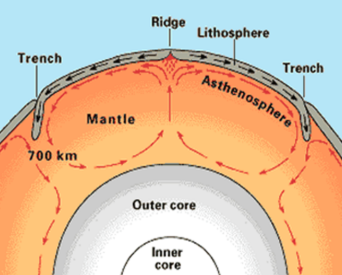
The crust is divided into tectonic plates which are moving due to convection currents in the mantle
Convection Currents
Molten rock (magma) in the mantle is heated by the outer core. This causes the rocks to become less dense and rise. When the rocks reach the crust, they spread outwards, dragging the tectonic plates with them. When the rock cools it sinks back down.
This process is repeated many times and the circular motion is called a convection current.
Ridge Push and Slab Pull
Ridge push is when rising magma at constructive plate margins pushes the plates apart.
Slab pull is when the plates are pulled down into the mantle under the force of gravity
Describe the distribution of earthquakes |
Earthquakes are found along all plate margins
e.g. along the Mid-Atlantic Ridge and on The Pacific Ring of Fire.
However, some earthquakes form away from a plate margin
Explain the distribution of earthquakes |
Earthquakes occur when plate margins get stuck due to friction, and pressure builds and is suddenly released as the plates jerk past each other. The pressure is released as seismic/shock waves (vibrations)
Earthquakes sometimes occur away from plate margins due to human activity such as underground mining or oil extraction
Describe the distribution of volcanoes |
Volcanoes are found along constructive and destructive plate margins.
e.g. along the Mid-Atlantic Ridge and on The Pacific Ring of Fire.
However, some volcanoes form in the middle of a plate at a hotspot. E.g. Hawaii
Explain the distribution of volcanoes |
Volcanoes are found along constructive and destructive plate margins where hot molten magma from the mantle rises to the surface
Some volcanoes form in hotspots where the crust is thin and magma is able to break through to the surface
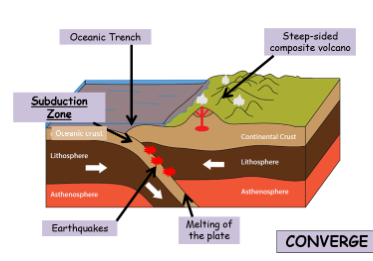
Destructive Plate Margin |
Plates move towards each other due to convection currents
The heavier oceanic crust subducts (sinks) under the continental
Where they sink, a deep oceanic trench is formed
Friction between the plates causes a build up of pressure which is released as an earthquake
The earthquake can cause a tsunami if underwater
Oceanic crust melts in the upper mantle and the magma rises through cracks in the crust to form violent composite volcanoes
Earthquakes: violent. Up to 9.5 in magnitude
Volcanoes: Explosive volcanoes (composite)
Examples: South American Plate
Constructive Plate Margin
Plates move away from each other
Hot, liquid rock (magma) rises from beneath the ground
Magma cools and forms new oceanic crust
New mountains form under the sea
If mountains grow above the sea level they become islands
Earthquakes: Yes but small (5-6 magnitude)
Volcanoes: More gentle shield volcanoes
Example: North American and Eurasian forms Mid-Atlantic Ridge
Conservative Plate Margin |
Plates slide past each other either in different directions or in the same direction but at different speeds
Plate get stuck due to friction between the plates
Pressure builds and is released as an earthquake
Plate only move a few mm every time there is an earthquake
Earthquake: Violent
Volcano: None
Example: Pacific Plate and North American Plate forms San Andreas Fault
Earthquakes are measured on the…
Richter Scale: a scale that runs from 1 to 10.
Focus of an earthquake
Where the earthquake starts
Epicentre of an earthquake
The point on the Earth’s surface directly above the focus
Primary Effects meaning
impacts caused directly by the earthquake such as:
the ground shaking
buildings collapsing / infrastructure damage
death & injury
Secondary Effects meaning
impacts caused indirectly by the earthquake (knock-on-effects) such as:
homelessness
disease
fires
landslides
liquefaction
floods
tsunamis
costs
looting
mental illness
loss of business
Immediate Responses meaning
those that happen immediately such as search and rescue, medical aid, providing tents
Long term responses meaning
those that happen later such as rebuilding
What was Haiti like before the earthquake? And why was it so vulnerable?
80% of its people lived below the poverty line
Haiti is the poorest country in the Americas and one of the poorest in the world.
80% of schools were poor-quality private schools for which students had to pay on the door. State schools provided better education but too few places.
The country has been devastated by hurricanes many times.
86% of people in Port au Prince (the capital city) were living in slum conditions
Buildings (including government ones) were often cheaply and badly built, ignoring regulation codes.
Primary Effects of the Haiti 2010 earthquake |
220,000 people are estimated to have died, and more than 300,000 injured
25% of government employees in Port au Prince died and the police force collapsed
4,000 schools (70%) were damaged or destroyed.
The port and airport were severely damaged
Roads and communication links were damaged beyond repair
Secondary Effects of the Haiti 2010 earthquake |
1.5m people became homeless and had to live in refugee camps.
Cholera broke out in the refugee camps in October 2010. By July 2011 5,900 had died as a result of the outbreak and 216,000 were infected.
1 in 5 jobs were lost because so much industry was destroyed.
Only one third of the people in Port-au-Prince had access to clean tap water, mostly in the form of shared taps.
Looting became a serious problem
2 million were left without food or water
The number of tourists coming to the area reduced
Immediate Responses to Haiti 2010 Earthquake |
There were not official responses for the first 24 hours
Emergency services were slow due to blocked roads and destroyed communication systems
Many countries responded to appeals for aid, pledging funds and dispatching rescue and medical teams, engineers and support personnel.
There was much confusion over who was in charge, air traffic congestion, and problems with prioritisation of flights further complicated early relief work.
Port-au-Prince's morgues were quickly overwhelmed with many tens of thousands of bodies having to be buried in mass graves.
As rescues tailed off, supplies, medical care and sanitation became priorities.
Delays in aid distribution led to angry appeals from aid workers and survivors, and looting and sporadic violence were observed.
Bottled water and purification tablets were provided, The USA sent rescue teams and 10,000 troops - medical services and food
Long-term Responses to Haiti 2010 Earthquake |
The EU gave $330 million and the World Bank waived the countries debt repayments for 5 years. • 6 months after the quake, 98% of the rubble remained uncleared, some still blocking vital access roads. • The number of people in relief camps of tents and tarps since the quake was 1.6 million, and almost no transitional housing had been built. Most of the camps had no electricity, running water, or sewage disposal, and the tents were beginning to fall apart. • Between 23 major charities, $1.1 billion had been collected for Haiti for relief efforts, but only two percent of the money had been released • One year after the earthquake 1 million people remained displaced • The Dominican Republic which neighbours Haiti offered support and accepted some refugees. |
Christchurch Earthquake 2011 Primary Effects
185 deaths (115 from the CTV building)
80% of the city had no electricity
Severe damage to 50% of buildings in the city centre
2000 injured
Liquefaction – damage to buildings
Damage to 100s of km of water and sewage pipes
Christchurch Earthquake 2011 Secondary Effects
Schools were damaged which disrupted education
The city could not host rugby matches which brings in a huge amount of money
Damages estimated to be $40billion
Ongoing mental health issues
Damage to roads
Christchurch Earthquake 2011 Immediate responses
Emergency plans put into action within minutes
Water supply back to 70% of households within one week
Cared for the most vulnerable people
Ensured people were safe from dangerous buildings
Chemical toilets provided for 30,000 people
Areas were zoned to classify damage/cost of repairs
International aid provided ($6-7million and aid workers)
Christchurch Earthquake 2011 Long term responses
NZ government Provided temporary housing
Ensured all damaged housing was kept water tight
Restored all water and sewerage (by August!)
Roads and houses were cleared of silt (from liquefaction)
80% of roads repaired by August
$898 million paid in building claims
Why do people live in areas at risk from tectonic hazards?
Economic reasons
Geothermal energy can be used in areas near volcanoes
Fertile soils near volcanoes is good for farming
Mining provides energy and income
Tourism provides jobs and income
It can be cheaper to stay than to move to a new area
Geothermal Energy
Heat from magma sources close to the surface in volcanic areas can be used as a source of geothermal (heat from the earth) energy which can be harnessed to produce electricity. In these instances, superheated steam, created by the heating of water in permeable rocks by magma can be used to drive turbines. This use of energy is renewable and sustainable, it has the added advantage of being pollution free.
Example: Over 20 countries around the world generate geothermal power, including the US, Italy, New Zealand and Iceland.
Fertile Soils
Volcanic soils are some of the most fertile in the world due to the weathering of volcanic products such as ash lava and rock, which release valuable nutrients and minerals which enrich the soil as well as improving soil characteristics such as moisture retention. In tropical areas in particular, for example Hawaii, climate conditions mean that the weathering of lava etc. is fairly quick resulting in the growth of lush vegetation due to the rapid soil formation. As volcanic areas are therefore ideal for growing crops, they attract large populations.
Reason: Tourism
Explanation: Due to the spectacular scenery associated with volcanic landscapes and unique features such as lava flows and geysers, volcanoes, particularly those having experienced recent eruptive activity are particularly popular with tourists. This is a huge economic benefit due to the resulting multiplier effect. Tourism attracts custom for businesses such as hotel, cafes etc. creating jobs and improving the local economy.
Example: Yellowstone National Park in the USA with the famous Old Faithful geyser receives around 3 million visitors a year. Iceland is famous for its volcanic landscape and its hot springs and geysers have attracted many tourists. The Blue Lagoon, near Reykjavik is a spa popular with tourists for its known positive effectives on the skin.
Reason: Minerals
Explanation: Valuable minerals such as copper, gold, silver, lead, zinc and even diamonds are all associated with volcanic regions as they are associated with the rising magma which may cool and harden beneath the volcano. As hot water circulate within the cooled magma, the metals are taken by the water and re-deposited in greater concentrations. Thus volcanic areas are excellent areas for mining creating economic activities through job opportunities and the value of the mined minerals.
Why do people live in areas at risk from tectonic hazards?
Social reasons
People want to stay near their friends and family
The threat might not feel dangerous enough
People may not understand the risk
People are confident that buildings and warnings will save them
Monitoring, Prediction, Protection and Planning of/from volcanoes
Monitoring:
Changes in the shape of the ground
Tilt meters to show ground changes
Change in amount of gas released from the volcano
Small earthquakes near the volcano
Changes in temperature
Prediction:
Easier to predict than earthquakes
Many early warning signs given from the monitoring techniques above
Protection:
Buildings cannot be completely designed to protect from volcanoes
Some areas are not built on as they are ‘higher risk’
Some lava channels can be built to try to move lava away from populated areas
Planning:
Evacuation
No building zones
Education to know what to do
Training emergency services
First aid training
Warning systems in place
Monitoring, Prediction, Protection and Planning of/from earthquakes
Monitoring:
This is very limited: there can be some warning before an earthquake from seismographs but this is usually only a few seconds
Prediction:
Extremely difficult to predict time, date or an exact location.
Approximate locations can be given based on plate boundary locations
Protection:
Building earthquake resistant buildings:
computer-controlled weights on roof to reduce movement
automatic window shutters to prevent falling glass
open areas where people can assemble if evacuated
roads to provide quick access for emergency services
fire-resistant building materials
Sea walls in case a tsunami is triggered
Planning:
Earthquake drills (in Japan on Sept 1st they practice these each year)
Training emergency services
Education to know what to do
Preparing emergency supplies
Securing object/furniture to walls
Having an emergency grab bag
Enforcing building codes
Advantages & disadvantages of monitoring and prediction |
Advantages:
Can be accurate for volcanoes
Can give vital warning signs for volcanoes allowing evacuation
Disadvantages:
Not effective for earthquakes
Can be very expensive
Advantages & disadvantages of protection |
Advantages:
Can be very effective for earthquakes
Can make sure that at least hospitals and schools are earthquake proof
LICs can use bamboo which is very flexible
Important as earthquakes cannot be predicted
Lots of research and investment is taking place
Disadvantages:
Very expensive
Can be hard to make the whole city earthquake proof if it has already been built
Difficult for LICs
Govs can accept bribes so building regulations are not enforced
Advantages & disadvantages of planning |
Advantages:
Very cheap method
Anyone can plan (e.g. putting together an emergency kit)
Can be very effective
Disadvantages:
In LICs, schooling may be bad so people do not have access to the education
Some people will not listen to the warnings
Requires an organised government
Natural hazard meaning
a natural process which could cause death, injury or disruption to humans, property and possessions
Geological hazard
hazards caused by land and tectonic processes
meteorological hazard
hazards caused by weather and climate
causes of earthquakes
caused when 2 plates become locked, causing friction to build up
from this stress, the pressure will eventually be released, triggering the plates to move into a new position.
this movement causes energy in the form of seismic waves, to travel from the focus towards the epicentre
as a result, the crust vibrates triggering an earthquake.
Volcanic hazards
ash cloud: small pieces of pulverised rock and volcanic glass which are thrown into the atmosphere
gas: sulphur dioxide, water vapour and carbon dioxide come out of the volcano
lahar: a volcanic mudflow which usually runs down a valley side on the volcano.
pyroclastic flow: a fast moving current of super-heated gas and ash (1000 degrees celsius). They travel at 450mph
volcanic bomb: a thick, viscous lava fragment that is ejected from the volcano
features of volcanoes
crater: top of volcano where magma erupts from
magma chamber: where the molten rock (magma) is stored beneath the ground
main vent: pipe that connects the magma chamber to the crater
secondary vent: pipe formed at the side of the volcano when the main vent is blocked