Physical Geography Exam 4
1/134
There's no tags or description
Looks like no tags are added yet.
Name | Mastery | Learn | Test | Matching | Spaced |
|---|
No study sessions yet.
135 Terms
Alfred Wegener
he found out that continents seem fixed today, but coastlines fit together, Pangea.
Alfred Wegener could not provide a convincing mechanism for how continents moved
Why was the theory of continental drift rejected?
Evidence for the current scientific theory of Plate Tectonics
Midocean ridges, Paleomagnetism, and Seafloor spreading
Internal heat → upwelling of magma/convection currents and Active plate boundaries
What drives plate tectonics?
Acrreted Terrane
grow by accumulation, pieces of lithosphere collide/fuse with another are blocks of continental fragments and oceanic islands that have collided with a continent at a convergent plate boundary and are now permanently attached.
Hot spot
40-60 around world, Hawaiian islands, don’t know format
Mantle Plumes
localized hot spots are not associated with plate boundaries
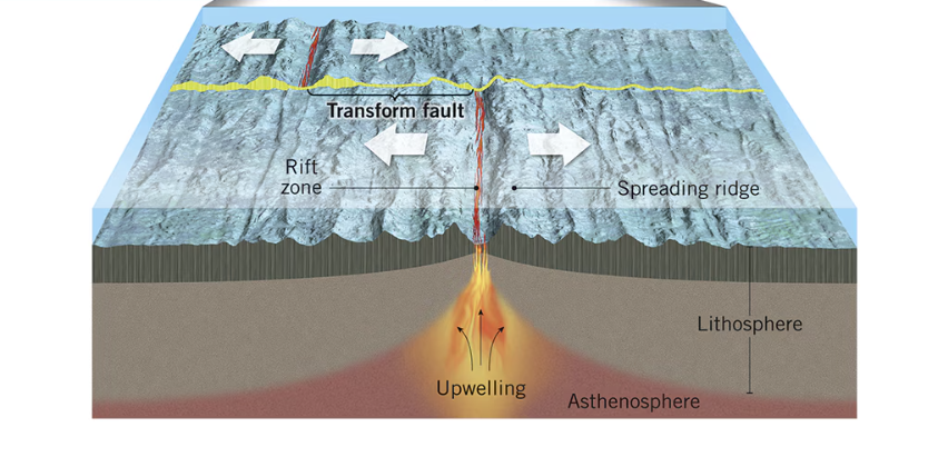
Transform boundaries
slip slide, can snag, can create earthquakes, plates laterally slip past each other, EQ’s are shallow but powerful, San Andreas Fault

Divergent boundaries
line upwelling magma, where 2 plates spread apart, shallow focus EQ’s and volcanic ranges, like finger nails growing, Iceland ridge on boundary of North American and Eurasian plate
Convergent crustal boundaries
ocean-continent, ocean-ocean, and continent-continent
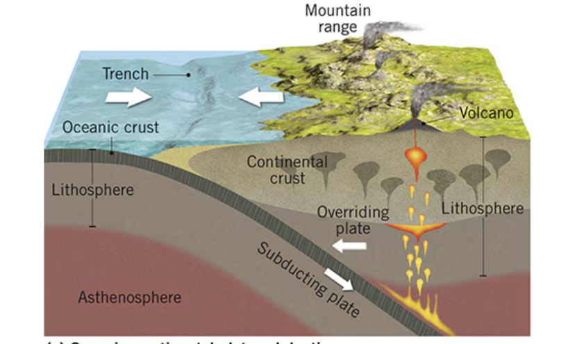
Ocean-Continent convergent boundary
continental rock is less dense, trenches and mountains, deep powerful EQ’s, subduction, West coast of South America Andes mountains. Cascades- Mt. St. Helens, Mt. Rainer
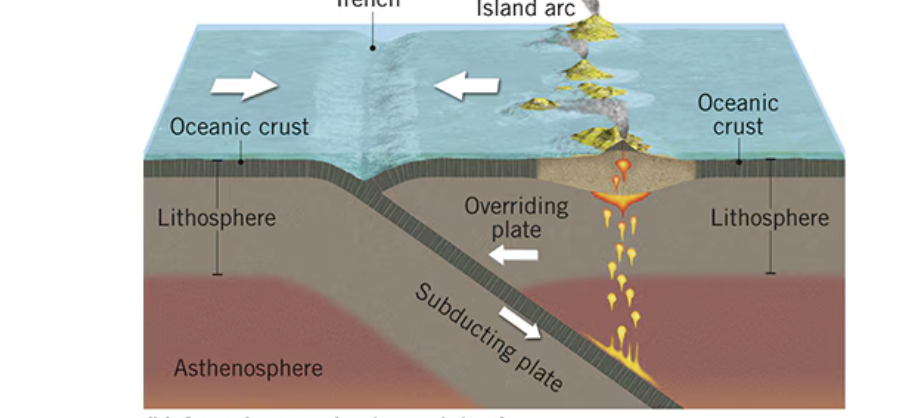
Ocean-Ocean convergent boundary
denser ocean plate subducts, trenches and island arcs, both deep and shallow EQ’s, aleutian arc off Alaska, volcanic arc of the pacific, Japan and west edge of asia
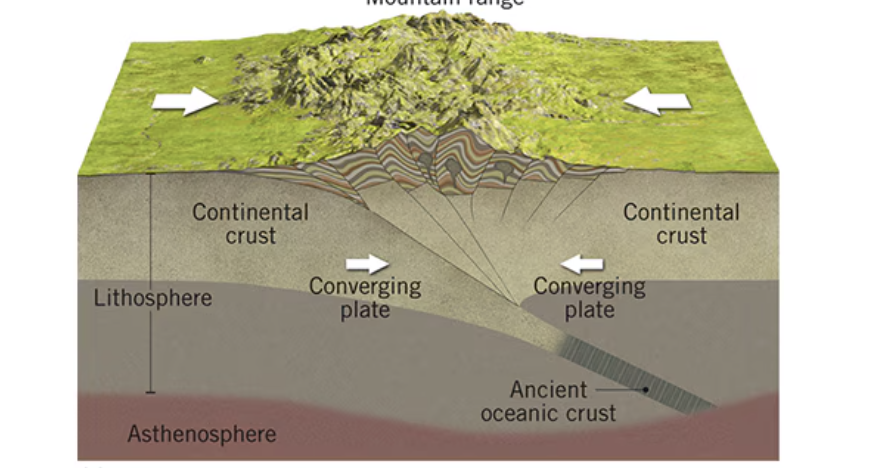
Continent-Continent convergent boundary
suturing, crusts too buoyant to subduct, shallow EQ’s are common, Himalaysan mountains
Subduction
recycling of crust material

Pacific Ring of fire
volcanoes and earthquakes help form new landforms, it surrounds the pacific ocean
Along tectonic plate boundaries, forming belts like the Pacific Ring of Fire, and at hotspots in the middle of plates. At convergent boundaries, one plate subducts under another, causing rock to melt and form volcanoes
Where are volcanoes distributed on Earth’s surface, and why at those places?
Magma chemistry and Confining Pressure
Volcanic activity is determined by _____ _____ and ______ ______
Felsic and Mafic magma
Volcanoes are classed by styles of eruption and quantity of silica matters
Felsic/High silica magma
-rich in feldspar and silica (quartz); silicate minerals (SiO2) are 95% of crust
-The most common rock is granite, typical of Earth’s crust
-Magma heavy in silica will tend to clog volcanic neck, produce violent eruptions
-lower density
-compared to peanut putter
Mafic/Low silica magma
-rich in magnesium and iron
-Common rocks include gabbro and basalt, typical of the ocean crust
-magmas are less viscous, flow more evenly, less explosiveness, builds layers
-higher density
-compared to syrup
Shield volcanoes
layers of thin lava, less pyroclastic material
Flood basalt
-a vast outpouring of smoothly flowing lava, often accompany mass extinctions, more lava comes out of these than all of the other volcanoes combined, Colombia Plateau
-large-scale outpourings of basaltic lava covering an extensive area of Earth’s surface.
extrusive igneous features: e.g., Siberian Traps, Deccan Traps
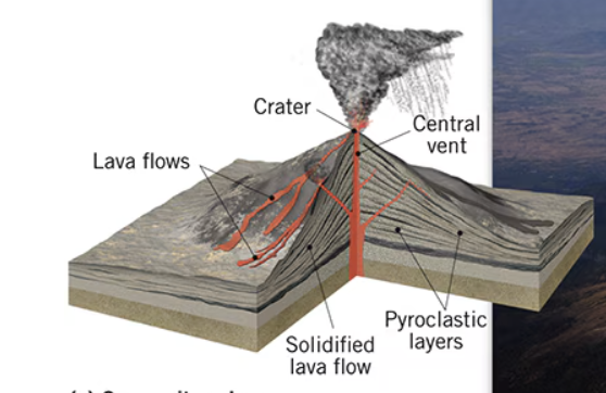
Composite volcano
higher silica lavas, alternative layers, steep slopes
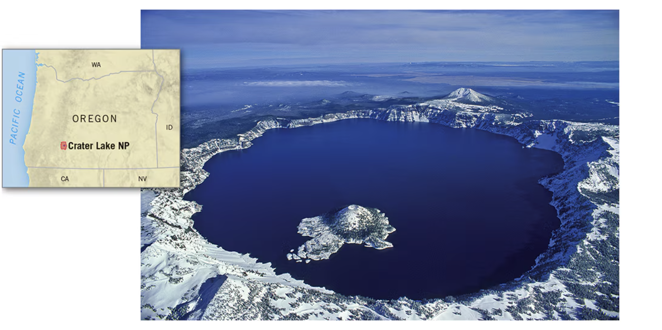
Calderas
crater lake, Oregon is a collapsed volcano
Igneous intrusions
molten rock disintegrates crust, plutons cause stoping
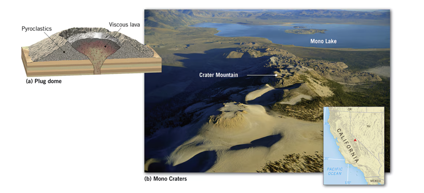
Lava dome volcanoes
have masses of very viscous lava, such as high-silica rhyolite, that are too thick and pasty to flow very far. Instead, lava bulges up from the vent, and the dome grows largely by expansion from below
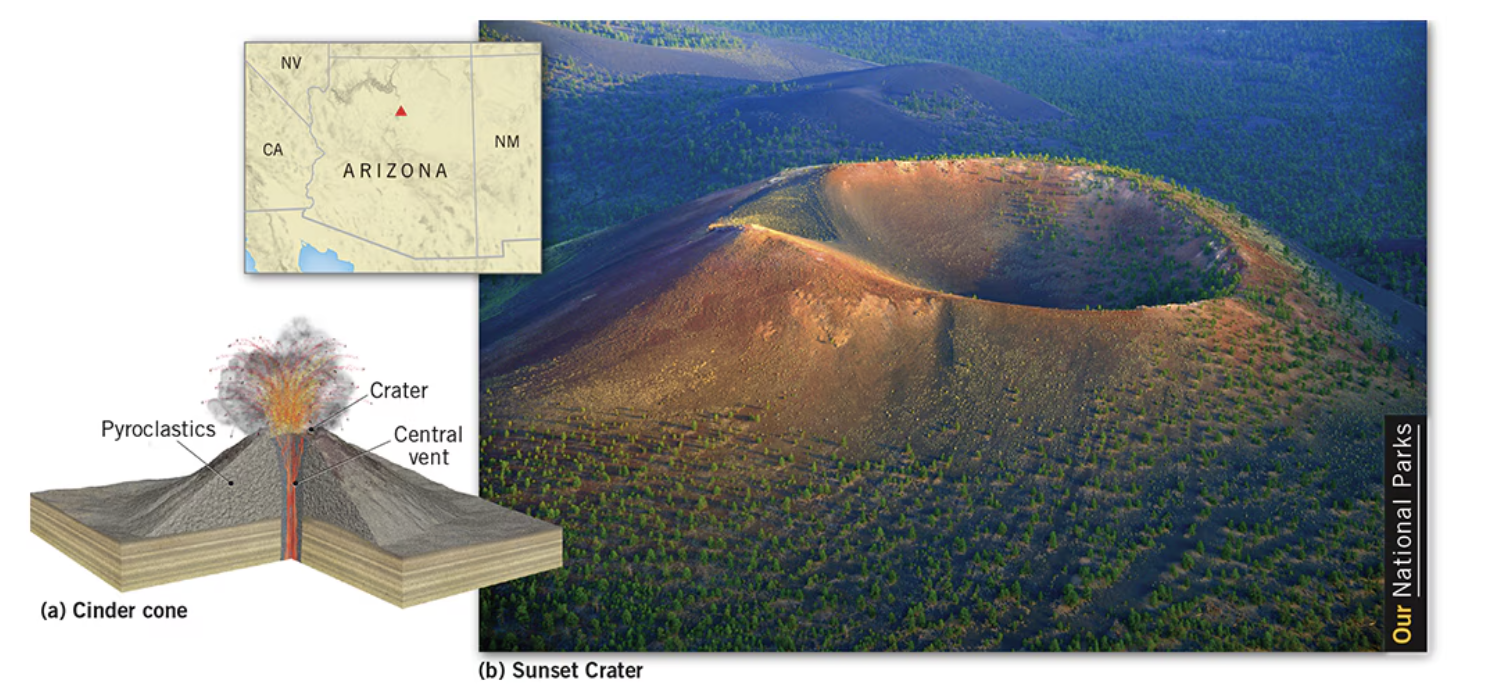
Cinder cone volcanoes
the smallest of the volcanic peaks. Their magma chemistry varies, but basaltic magma is most common. They are cone-shaped peaks built by the unconsolidated pyroclastics that are ejected from the volcanic vent
Plutons
-large bodies of igneous magma that cool/harden underground, revealed later by erosion.
-intrusive igneous features: e.g., Batholiths, Volcanic Necks, Laccoliths, Sills, Dikes
Batholith
large igneous intrusion can deform surface, half dome

Dike
vertical sheet of magma thrust up into pre-extisting rock, erosion leaves long and narrow ridge

Folding
-Appalachians created by colliding, compressing boundary; sedimentary rock layers were warped.
-lateral compression, when two forces act towards each other from opp. sides, rock layers bend into folds
Faulting
-Sierra Nevada are a classic fault-block mountain thrust upward.
-rock breaks and moves along zones of weakness in the crust begins as sudden
-earthquakes hasten their spreading
Horst
a block pushed upward (relative to blocks on either side) by faulting
Graben
a block that has been lowered relative to the blocks on either side due to faulting.
Joint
fracturing along which no movement has taken place, there are many more joints than faults in crust
Weathering and mass wasting are often called “preliminaries to erosion.” Why?
they break down and transport rock and soil, providing the material that erosion then carries away.
Denudation
disintegration, wearing away, and removal of rock material
They act as pathways for weathering agents to penetrate the rock, significantly increasing the rock's surface area and accelerating the breakdown process
Why are rock openings/jointing important in weathering?
Weathering
destroys exposed bedrock, breaks it into smaller fractions, depends on rock openings
Types of rock openings
joints, faults, lava vesicles, and solution cavities
Mechanical weathering
-frost wedging, salt wedging, temperature changes, exfoliation
-physical disintegration of rock without changes to its chemical composition
-frost wedging/shattering and salt wedging
Chemical weathering
-oxidation, hydrolysis, carbonation (‘rotting’ is most common in humid areas)
-decomposition of rock material through chemical alteration of minerals
-Oxidation, Hydrolysis, and Carbonation
Biological weathering
-plants and animals
-juniper pine took root in a limestone chunk
-lichens on rock surface
Soil, sand, regolith, and rock move downslope
typically as a mass, largely under the force of gravity, but frequently affected by water.
After rock weathers in place [in situ], what happens then?
Mass Wasting influences
Angle of repose (slope steepness), available water/soil moisture, amount of clay, earthquakes
Mass wasting
weathered material moved by gravity (Grand Canyon)
Speed and Moisture content
Mass wasting is classified by ______ and _____ ______
Fall
-rock moving through air via gravity (evidenced by talus deposit at base of cliff)
-pure gravity, talus cone
Slide
-sudden detaching of rock from steep slope, still in contact with slope
-slope may collapse even without soil being saturated
Slump
-rotational slip of solid mass of earth material lubricated by water
Flow
earthflow (wet, fine-grained material) and mudflow (wetter, faster moving)
Creep
tilted fences posts or leaning headstones. Solifluction: freeze-thaw cycle in Tundra
Exfoliation
“unlocking” can happen after erosion exposes an exfoliation dome, Yosemite
Rain and Heat
Average depth of weathering is greatest near equator because of ______ and ______
Running water (landscape)
______ _______ is the single most important agent of landscape modification
Interfluve
a ‘height of land’ that separates adjoining valleys
Streamflow
the channeled movement of water along a valley bottom
Overland flow
unchanneled downslope movement of surface water and water runs across surface after rainfall
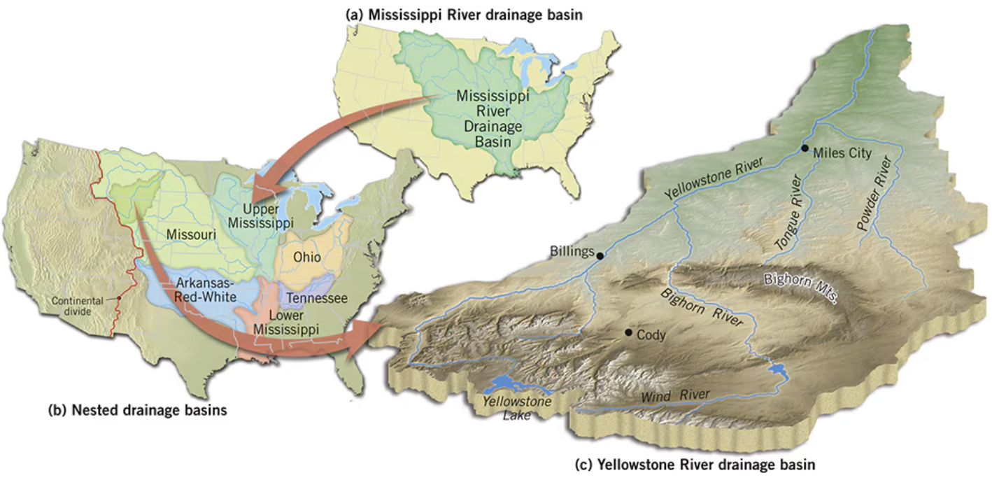
Drainage Basin/Watershed
all of the area that contributes overland flow, streamflow, and groundwater to that stream.
In other words, it consists of a stream’s valley bottom, valley sides, and those portions of the surrounding interfluves that drain toward the valley
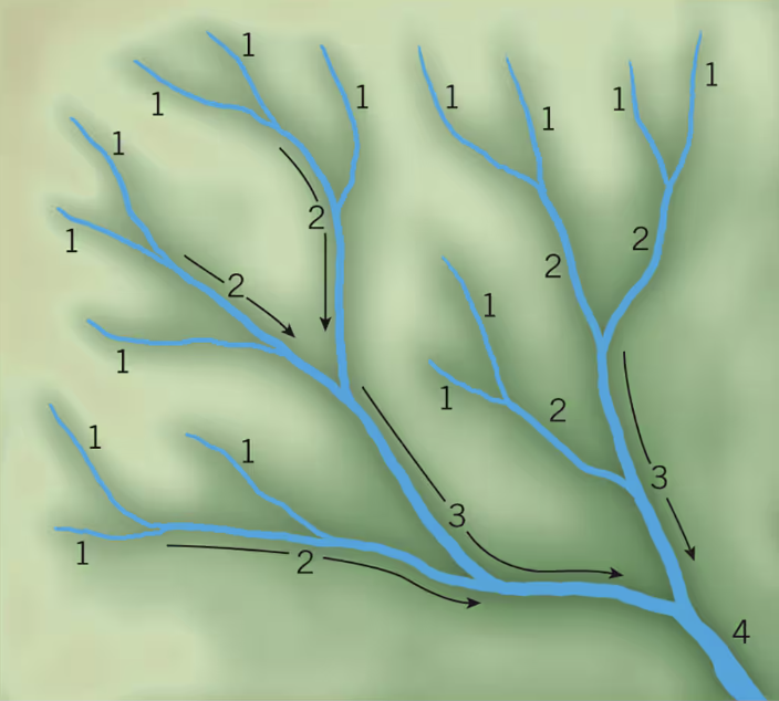
A first-order stream, the smallest stream, has no tributaries. Where two first-order streams unite, they form a second-order stream. At the confluence (joining) of two second-order streams, a third-order stream begins, and so on and so forth
How are stream orders classified within a drainage basin?
Types of Fluvial Erosion
Overland flow (splash erosion, sheet erosion, rill erosion, and gully erosion) and Streamflow (corrosion,
Types of Fluvial Deposition
splash, sheet, rill, and gulley
Solution, Suspension, Saltation, Traction
Streams move solid material in one of several ways depending upon particle size:
By ______ (dissolved), ______ (stream flow), ______ (bouncing), and ______ (pushing)
Alluvium
deposit of clay, silt, sand, and gravel sediments left by flowing water in a river valley or delta
Stream competence
largest particle size carried
Stream capacity
maximum solid load transported
Perennial streams
permanent flow in humid regions
Intermittent streams
seasonal flow, they only flow for one part of the year
Ephemeral streams
unpredictable and dependent on rainfall
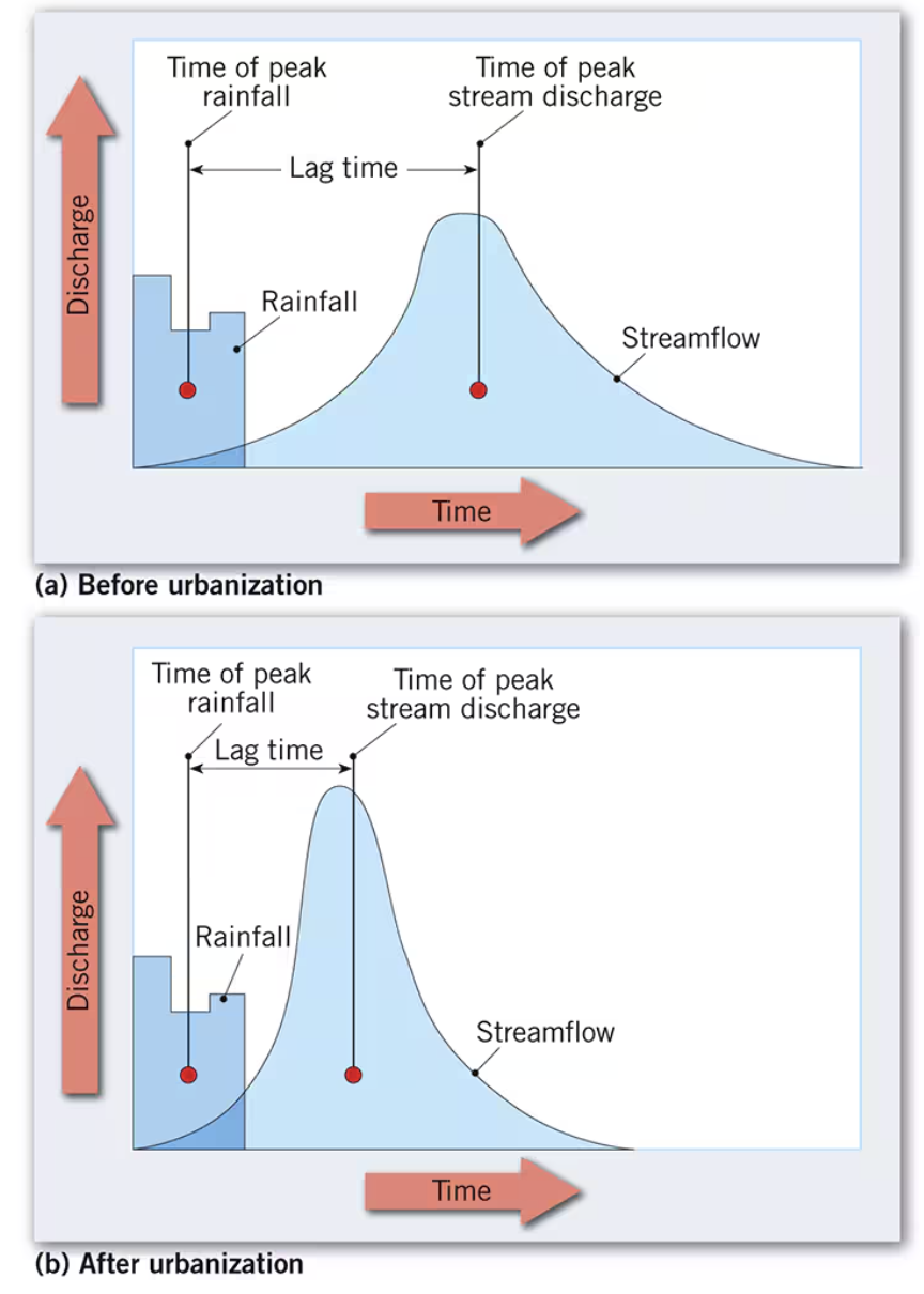
Hydrograph, Volume/Discharge and Max velocity in the middle of the stream
How do we measure streamflow?
The average time between floods of a certain size
a “100-year flood” refers to stream discharge that has a 1 in 100 (1 percent) probability of being exceeded in any single year.
What is meant by a flood recurrence interval?
Gravity pulls the water downhill and sediment goes along with it
How are sediments carried in channel flow?
Consequent streams
normally the first to develop on newly uplifted land, and many streams remain consequent throughout their evolutionary development
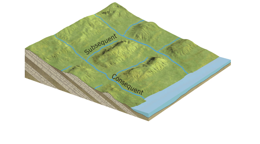
Subsequent streams
Streams that develop along zones of structural weakness
they may erode their channels along an outcrop of weak bedrock or perhaps follow a fault zone or a master joint.
Subsequent streams often trend at right angles to other drainage channels.

Antecedent streams
a stream that predates the existence of the hill or mountain through which it flows
Superimposed streams
existed when the landscape was higher, but this older, higher landscape has since largely or entirely eroded away
Dendritic
Most common type of stream drainage patterns is ______
Increased flow and velocity of water wears away at the valley and erodes it.
How do floods deepen valleys?
They have energy that they need to exert, if there is room for them to move they will
Why do streams meander (widen) and cause headward erosion(lengthen)?
Knickpoint migration
migrates upriver rapids/waterfalls. They occur in steeper sections of the channel, and their faster, more turbulent flow intensifies erosion.
Cutoff meanders (oxbows)
Often a meander loop is bypassed as the stream channel shifts by lateral erosion, cuts a new channel across its neck, and starts meandering again, leaving the old meander loop as a cutoff meander. The cutoff portion of the channel may remain filled with water for a period of time
Natural levees
a ridge of sediment, or flood deposits, that builds up along the banks of a river during a flood
Stream Gradient/Slope
determines cutting power
young stream = steep
mature stream = moderate
old stream = gentle slope
Drainage Types
dentritic, trellis, radial, centripital
shaped by surface structure
Deposition, Erosion, Point bar, Cut bank
inside bend, outside bend, slowest, fastest
Mississippi River: dams and artificial levees
How do humans modify rivers for flood control?
Stream terraces
This remnant of the previous valley floor

Entrenched Meanders
form when an area containing a meandering stream is uplifted slowly and the stream incises downward while retaining its meandering course

Sand, impermeable surfaces, wind action, most streams are ephemeral (flow only following a rainfall)
Yet, alluvium is very common in deserts, and so are basins of internal drainage.
desert terrain is stark and abrupt
Mechanical weathering is still dominant, but slower
Produces sharp angular particle formation
Soil is thin/absent exposing bedrock
What makes the desert a specialized environment?
Running water (deserts)
______ ______ is actually the single most important agent of erosion in deserts
Surface water in the desert
exotic streams (e.g., Nile River, Colorado River),
ephemeral streams, playas, and saline lakes.
Ephemeral
most streams in the desert are ______, yet alluvium is very common in deserts
Aeolian erosion
deflation (blowout of loose material) and abrasion (pitting by flying sand grains)
Aeolian transportation
suspension, saltation, traction (similar to streams, but no salts in solution
Fluvial erosion in arid lands
occurs infrequently flash floods, still carves desert stream channels, water flows only after it rains
Basins of interior drainage
these watersheds do not drain into the ocean
example: great basin of Nevada
Playa
dry lake bed in the desert
Inselberg/Bornhardt
an isolated hill rising abruptly from a plain. sugar loaf mountains in rio
Aeolian process
wind’s ability to shape the earths surface, wind can’t work alone
Deflation
shifting of loose particles via wind (blowout)