unit 3 geology exam
1/68
There's no tags or description
Looks like no tags are added yet.
Name | Mastery | Learn | Test | Matching | Spaced |
|---|
No study sessions yet.
69 Terms
what characteristics of minerals affect the distance of seismic waves
density
elasticity
mineral composition
denser and more elastic the mineral, the farther seismic waves can travel through it before dissipating
Earthquake
vibration of Earth produced by the rapid release of energy
Epicenter
location on Earth’s surface that lies directly above the focus of an earthquake
Hypocenter
zone within Earth where rock displacement produces an earthquake
Foreshocks
small earthquakes that often precede a major earthquake
Aftershocks
smaller earthquake that follows the main earthquake
What is a megathrust earthquake and where would you find them?
Powerful earthquake that occurs at subduction zones, where one tectonic plate is forced beneath another
occur along convergent plate boundaries
What is a seismometer and what does it record?
An instrument that detects and measures the vibrations caused by seismic waves during an earthquake
records intensity, duration, and direction of these ground movements, providing data on the earthquake's strength and location
Compare and contrast the two types of seismic waves (i.e., Body Waves vs Surface Waves), and be sure to provide two examples of each
body waves travel through the earth
P waves go though liquid, think slinky, and faster
S waves do not go through liquid, think garden hose, and 2nd fastest
surface waves stay on the surface
they are the slowest waves but have the most shaking
L waves think back and forth
R waves think circle motion
Compare and contrast the Mercalli Intensity Scale and Moment Magnitude
The Mercalli Intensity Scale measures earthquake effects and damage, while the Moment Magnitude Scale measures total energy released.
Mercalli varies by location, Moment Magnitude provides a single global value.
How does crust type or material affect the propagation of seismic waves?
Seismic waves travel faster in dense, rigid materials (like rock) and slower in softer materials (like soil).
Softer materials also absorb more energy, weakening the waves.
What types of rocks give us an idea of the original/initial composition of the earth? Why?
Peridotite and basalts because from the mantle it is carried from the mantle to the Earth’s surface providing clues about the Earth’s interior.
Meteorites represent the original material from which the Earth and other planets formed
What methods do we use to gain information about the structure of the earth? Why?
Seismic waves, drilling, and magnetic/gravitational field measurements to study Earth’s structure.
Seismic waves reveal interior layers by how they travel through Earth
Drilling sample materials directly
Magnetic and gravitation measurements indicate variations in earth’s composition and density
What is the Moho?
boundary between the Earth's crust and the mantle
By what mechanism is heat transferred from the core to the crust of the planet
conduction
convection
What were the two sources of Earth’s original heat?
accretional heat
radioactive decay
What seismic evidence tells us the outer core is molten and not solid?
shadow zones
What is the major control on the distribution of earthquakes (globally)?
plate boundaries
What conditions are needed for the outer core to be in a liquid state while the other Earth layers are not? Is the outer core the hottest part of the Earth, since it is molten?
outer core is liquid due to high temperature and lower pressure
inner core is hotter but solid due to extreme pressure
how do we know about the interior of the earth? how do we know it is layered?
volcanic rocks
meteorites
waves that do not travel through liquid
s waves
how does heat move or energy travel?
conduction (contact)
convection (boil)
radiation
Hydrologic Cycle
movement of water
Watershed/drainage basin
area of land drained by a stream
Headward erosion
extension upslope of the head of a valley due to erosion
Laminar Flow
movement of water particles in straight-line paths that are parallel to the channel
Turbulent Flow
erratic movement of water often characterized by swirling, whirlpool-like eddies
What information does a drainage pattern provide? include 2 examples
shows how water flows over land and provides clues about the land's structure and rock types
ex: dendritic and trellis
What factors affect flow velocity?
channel gradient (slope) [steeper=faster]
channel shape (cross-sectional area)
channel size and roughness [rough=slower]
discharge (amount of water flowing)
Explain how channel shape affects flow velocity?
the less contact the water makes with the banks and bed of a channel, the faster the flow
List and define the three types/groups of sediment transport
bed load = sediment that rolls, slides, or bounces along riverbed
suspended load = find particles, like silt and clay, are carried within the water column
dissolved load = soluble materials, such as minerals, are dissolved in water
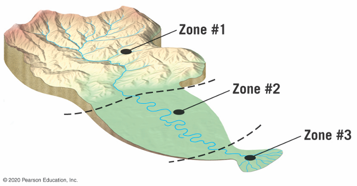
On the following model of stream, label zone of sediment production, zone of transportation, zone of deposition. Additionally, list and describe the relative gradient and energy of the streams in each section and what size particles you would expect to find in each section
zone 1 = zone of sediment production
gradient: high
energy: high
particle size: high (boulders and cobbles)
zone 2 = zone of transportation
gradient: moderate
energy: moderate
particle size: medium (sand and gravel)
zone 3 = zone of deposition
gradient: low
energy: low
particle size: fine (silt and clay)
top is headwaters
middle is trunk stream
bottom is mouth
the amount of water that runs off as opposed to infiltrates into the ground depends on?
intensity and duration of rainfall
amount of moisture already in soil
surface material
slope of land
extent and type of vegetation
Porosity
percentage of total volume of rock or sediment that consists of pore spaces
amount that is stored
Permeability
the ability to transmit fluids
how much fluid can be transmitted
Aquifer
rock or sediment that groundwater moves easily through
allows water to move
Aquitard
impermeable bed that hinders or prevents groundwater movement
does not allow water to move
What is the general shape of the water table? – is it a flat, horizontal line? Why?
it is the shape of the land surface
it is not flat
it rises and falls with topography due to recharge, permeability, and drainage
What characteristics make a good aquifer? Be sure to use permeable and porous in your answer
a good aquifer is highly porous, meaning it has many spaces to hold water
and is high permeable, meaning it allows water to flow through it easily
Why and how does a cone of depression form?
it forms when water is pumped from a well, lowering the water table around its cone-shape
removing water faster than it can replenish
Compare and contrast springs, hot springs, and geysers.
springs = natural flow of ground water to surface, typically at normal temperature
hot springs = groundwater heated by geothermal energy before emerging at surface
geysers = hot springs that periodically erupt due to pressure buildup in underground chambers
comparison = all involve groundwater reaching the surface
In what circumstances is ground water a nonrenewable resource?
OVER PUMPING AND CONTAMINATION
when it is extracted faster than it can be naturally replenished
often in arid regions or areas of heavy overuse
If you collect water from a stream in a jar, what part of its load will settle to the bottom, and what portion will remain in the water indefinitely? What part of the stream’s load would probably not be represented in your sample?
suspended load will settle on the bottom of the jar
dissolved load will remain in the water indefinitely
bed load is likely to be missed
You are at the grocery store with a friend looking to buy bottled water. Some brands of bottled water boast that their water is artesian. Other brands promote that their water is from springs. Your friend asks, “Is artesian water or spring water better than other sources?” How would you answer?
Neither is better, both are clean sources, but the choice would be a preference
factors that affect stream or water velocity
topography or terrain
friction
total amount of water
how do you recharge ground water?
rain
trigger
event that causes the slope to become unstable
Angle of repose
the steepest angle at which material remains stable
Liquefaction
during periods of ground shaking, water-saturated surface materials behave as fluid-like masses that flow
Talus Slopes
built by rock falls
Scarp
a slope
How is mass movement different from erosion driven by streams and glaciers? Example?
involves the downward movement of soil, rock, or debris under the influence of gravity, without the aid of water, wind, or ice. Erosion driven by streams and glaciers involves the transportation of materials by flowing water or moving ice
Example: A landslide (mass movement) versus sediment transported by a river (erosion)
What are four controls/triggers of mass movement? Be sure to explain how each one works
GRAVITY AND TRIGGERS CAUSE
Water: Too much water makes the ground slippery and heavy, causing it to slide downhill (like after heavy rain).
Steep Slopes: Steep hills are more likely to have materials slide down because gravity pulls stronger on them.
No Plants: Without plant roots to hold the soil in place, the ground is more likely to move (like when trees are cut down).
Earthquakes: Shaking from earthquakes can loosen the ground and make it move suddenly.
What are the three ways that material can move during mass movement?
fal
slide
flow
Compare and contrast Debris Flows and Earth Flows
debris flows – fast, mix of large minerals with water, very destructive
earth flows – slow, find minerals, gradual movement, less destructive
both – involve water, loose material downhill movement
List two observations which likely indicate that a slope is failing
cracks forming on slope surface
sudden movement or tilt of structures of tilt on slop
Zone of accumulation
part of a glacier that is characterized by snow accumulation and ice formation
outer limit of this zone is the snowline
Zone of wastage
part of a glacier beyond the snowline, where annually there is a net loss of ice
Equilibrium line
boundary on a glacier where snow accumulation equals snow melting
Glacial erratic
ice-transported boulder that was not derived from the bedrock near its present site
hydraulic gradient
slope of the water table
is determined by finding the height difference between two points on the water table and dividing by the horizontal distance between the two points
What is the difference between an ice sheet and a glacier?
ice sheet covers a large area, like antarctica, while a glacier is smaller and typically found in mountains or valleys
What is the glacial budget and how does that affect the glacier?
balance between accumulation [gains = growth] and ablation [losses = recede]
accumulation exceeds loss, the glacier grows; if loss exceeds accumulation, the glacier shrinks
How do glaciers erode the landscape?
through plucking, where they pick up rocks, and abrasion, where the ice and carried debris scrape and grind the ground beneath them
What are the three components of the Milankovitch Cycles and what is their net effect?
eccentricity = variations in shape of earth’s orbit about the sun
obliquity = changes in the angle of axis
precession – wobbling of earth’s axis
net effect – they influence earth’s climate by altering the amount and distribution of solar energy, contributing to long term climate patterns like ice ages
Other than the Milankovitch Cycles, what are two other factors that can affect climate?
volcanic activity
solar variability
If Earth were to experience another Ice Age within the next few hundred thousand years, one hemisphere would have substantially more expansive ice sheets than the other, would it be the Northern or Southern Hemisphere? Why?
northern hemisphere because it has more land at higher latitude allows the largerice sheets to form
what are the seasons based on?
tilt of the earth
what are shadow zones?
zones where seismic waves cannot reach